💥Join UPSC 2027,2028 Mentorship (July Batch) + XFactor Notes & Microthemes PDF

Subject: Geographical Features

  • [22nd July 2025] The Hindu Op-ed: Water, energy demand spotlights risk of human-induced quakes 

    PYQ Relevance:

    [UPSC 2020] Discuss the geophysical characteristics of Circum-Pacific Zone.

    Linakge: This question is about a region known for earthquakes and volcanoes. The article mainly talks about quakes caused by human activity but also mentions that these usually happen in places already on fault lines or where tectonic plates are shifting—areas like the Circum-Pacific. So, it’s important to understand these natural zones when looking at how human actions might trigger earthquakes.


    Mentor’s Comment:  Human-induced earthquakes are increasingly drawing scientific and public attention, as research shows that human activities like groundwater extraction, dam construction, and fracking can trigger or accelerate seismic activity, particularly in tectonically sensitive regions such as Delhi-NCR, the Western Ghats, and parts of Maharashtra and Kerala.

    Today’s editorial analyses the Issues related to Human-induced earthquakes in India. This topic is important for GS Paper I (Geography), GS Paper II (Governance) and  GS Paper III (Disaster Management) in the UPSC mains exam.

    _

    Let’s learn!

    Why in the News?

    Recent studies in India have highlighted a correlation between excessive groundwater depletion and increased seismic events, especially in Delhi.

    What are human-induced earthquakes?

    • These are earthquakes triggered by human activities rather than natural tectonic movements. Activities like mining, groundwater extraction, building dams, and fracking disturb the earth’s crust, causing seismic activity. Over 700 human-induced quakes have been recorded globally in the last 150 years.


    How do activities like groundwater extraction and dams trigger quakes in India?

    • Groundwater Depletion Weakens Crustal Stability: Excessive extraction of groundwater reduces pore pressure, leading to a shift in stress within the earth’s crust. Eg: In Delhi-NCR, increased seismic activity between 2003–2012 has been linked to excessive groundwater loss.
    • Reservoir-Induced Seismicity (RIS): The weight of large reservoirs exerts additional pressure on underlying faults, triggering quakes. Eg: The 1967 Koynanagar earthquake (magnitude 6.3) was linked to the Koyna Dam in Maharashtra.
    • Water Infiltration into Fault Zones: Water from reservoirs or excessive irrigation can seep deep into fault lines, lubricating them, and making them more likely to slip. Eg: Seismic tremors near Mullaperiyar Dam in Kerala are suspected to be induced due to water infiltration in a seismically sensitive region.
    • Load Variation Due to Filling and Emptying of Dams: Rapid filling or draining of reservoirs changes the stress distribution, causing small or moderate tremors. Eg: In the Himalayan region, such stress changes are a concern for dams like Tehri Dam.
    • Ground Subsidence from Overuse of Aquifers: Excessive groundwater extraction leads to land subsidence, altering the natural equilibrium of stress in the crust. Eg: Regions in North Gujarat have experienced subsidence, making them more vulnerable to fault reactivation and quakes.

    Why is Delhi-NCR prone to quakes from groundwater loss?

    • Rapid Groundwater Depletion Alters Stress Fields: Excessive groundwater extraction reduces the hydrostatic pressure underground, disturbing the natural stress balance in fault zones. This stress redistribution can reactivate dormant faults, triggering seismic activity. Eg: Studies from 2003–2012 show increased microseismic activity in parts of Gurgaon and Faridabad, correlated with falling water tables.
    • Aquifer-Related Land Subsidence: Continuous overuse of aquifers causes the land to sink (subsidence), which can strain the Earth’s crust and disturb nearby fault lines. In Delhi-NCR, land sinking has been recorded in Dwarka, Kapashera, and parts of Noida, increasing quake risk. Eg: A 2021 study by IIT-Kanpur showed that excessive aquifer use led to ground subsidence and elevated seismic hazard.
    • Built-Up Pressure on Seismically Active Faults: Delhi-NCR sits near the Mahendragarh-Dehradun fault and Delhi-Haridwar ridge, making it naturally earthquake-prone. When groundwater is extracted, it weakens the structural resistance of rocks, making nearby active faults more vulnerable. Eg: Minor tremors in Rohini and West Delhi (2020-21) were suspected to be linked to combined stress from tectonics and human activity.

    How does climate change contribute to seismic risks?

    • Melting Glaciers Increase Uplift Pressure: Rapid glacial melt in the Himalayas (due to rising temperatures) reduces surface weight. This triggers isostatic rebound — the crust rises and shifts, which can activate faults beneath. Eg: In Uttarkashi (Uttarakhand), increased seismic activity has been observed near retreating Gangotri Glacier, linked to glacial thinning and uplift.
    • Changing Rainfall Patterns Cause Landslides and Crustal Stress: Intense rainfall and flash floods (exacerbated by climate change) cause rapid groundwater recharge and erosion, disturbing fault stability. Eg: In Kodagu (Karnataka), unusually heavy rains in 2018 triggered landslides and minor tremors due to destabilized slopes and crustal shifts.
    • Sea-Level Rise and Coastal Seismic Pressure: Rising sea levels increase water load on coastal plates, especially in delta regions. This can suppress or activate tectonic stresses near coastlines. Eg: In Sundarbans (West Bengal), changes in sediment load and sea-level rise have raised concerns of future seismic risks in this low-lying, tectonically sensitive zone.
    What are the steps taken by the Indian Government?

    •  Seismic Zoning and Monitoring: India is divided into four seismic zones (II to V) to prioritize risk-based planning. The National Centre for Seismology (NCS) monitors seismic activity across the country in real-time.
    • Implementation of Earthquake-Resistant Building Codes: The Bureau of Indian Standards (BIS) has issued IS codes for earthquake-resistant construction.
    • Capacity Building and Public Awareness: NDMA and NDRF conduct training, mock drills, and awareness programs in vulnerable areas.

    Way forward: 

    • Integrated Land and Water Management: Promote sustainable groundwater use, recharge practices, and land-use planning to reduce land subsidence and seismic vulnerability.
    • Expand Monitoring and Preparedness: Enhance seismic monitoring networks and public awareness programs to improve early warning systems and disaster resilience.
  • In news: Kamchatka Peninsula

    Why in the News?

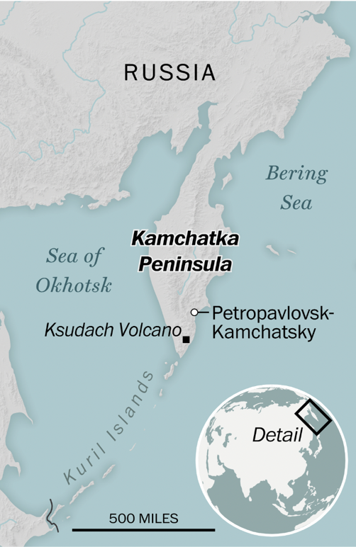
    Five strong offshore earthquakes hit Russia’s Kamchatka Peninsula, the strongest measuring 7.4 in magnitude.

    Kamchatka Peninsula

    About Kamchatka Peninsula:

    • Location: Situated in Far Eastern Russia, bordered by the Sea of Okhotsk (west) and the Pacific Ocean and Bering Sea (east).
    • Size and Shape: Stretches about 1,200 km north to south and 480 km at its widest point.
    • Area: Covers approximately 370,000 square kilometers—comparable in size to New Zealand.
    • Ethnic Composition: Majority are ethnic Russians; around 13,000 belong to the indigenous Koryak community.
    • Climate: Harsh with long, snowy winters and wet, cool summers.
    • Topography: Highest peak is Klyuchevskaya Sopka, an active volcano in the Eastern Mountain Range.
    • Global Recognition: Hosts the “Volcanoes of Kamchatka,” a UNESCO World Heritage Site.

    Tectonic Significance:

    • Geological Setting: Lies on the Pacific Ring of Fire, making it a global hotspot for seismic and volcanic activity.
    • Volcanic Density: Contains over 150 volcanoes, 29 of which are currently active.
    • Kuril–Kamchatka Trench: Located just offshore, reaches depths of about 10,500 meters and drives regional seismicity.
    • Tectonic Cause: Caused by subduction of the Pacific Plate beneath the Eurasian Plate.
    [UPSC 2004] Consider the following geological phenomena:

    1. Development of a fault 2. Movement along a fault

    3. Impact produced by a volcanic eruption 4. Folding of rocks

    Which of the above cause earthquakes?

    Options: (a) 1, 2 and 3 (b) 2 and 4 (c) 1, 3 and 4 (d) 1, 2, 3 and 4*


  • Disputes over Grand Ethiopian Renaissance Dam (GERD)

    Why in the News?

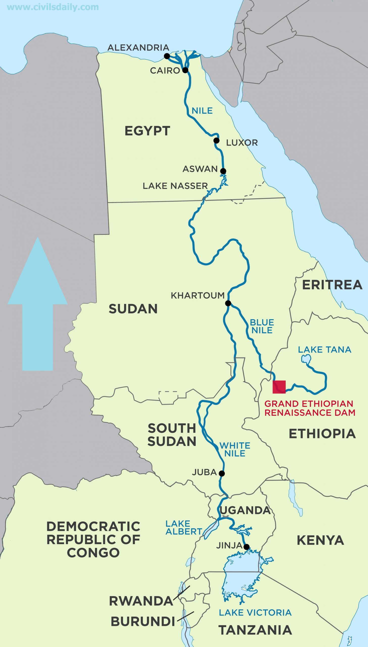
    The completion of Ethiopia’s Grand Ethiopian Renaissance Dam (GERD) has reignited tensions over Nile water rights, with Egypt and Sudan fearing reduced water flows.

    Disputes over Grand Ethiopian Renaissance Dam (GERD)

    About Grand Ethiopian Renaissance Dam (GERD):

    • Overview: Gravity dam on the Blue Nile near Ethiopia–Sudan border.
    • Construction Timeline: Under construction since 2011, led by Ethiopian Electric Power Corporation.
    • Capacity: Set to become Africa’s largest hydropower plant with 6.45 GW output.
    • Reservoir Size: Holds 74 billion cubic metres; filling may take 5–15 years.
    • Key Features: 145 m tall dam, 16 turbines, and a supporting saddle dam.
    • Purpose: Aims to power Ethiopia (65% population lacks electricity) and export surplus to neighbouring countries.
    • Disputes Around GERD:
      • Egypt’s Concern: Fears reduced water flow; Relies 90% on Nile; demands a binding filling agreement.
      • Sudan’s Worry: Concerns over flood risks and water regulation.
      • Ethiopia’s Stand: Asserts sovereign rights; began filling without consensus.
      • Stalled Talks: Tripartite negotiations have failed; Egypt warns of possible conflict.

    Back2Basics: Nile River

    • Overview: North-flowing, longest river in Africa at ~6,650 km.
    • Drainage Basin: Covers 11 countries—Tanzania, Uganda, Rwanda, Burundi, DRC, Kenya, Ethiopia, Eritrea, South Sudan, Sudan, and Egypt.
    • Main Tributaries:
      • White Nile: Recognized as the headstream, its most remote source is the Kagera River in Burundi, flowing through Rwanda into Lake Victoria. It officially begins at Jinja, Uganda, where it exits Lake Victoria.
      • Blue Nile: Originates from Lake Tana in Ethiopia and merges with the White Nile at Khartoum, Sudan.  Supplies over 80% of total Nile flow by the time it reaches Egypt.
    • Lifeline Status: Vital for Egypt and Sudan’s drinking water, irrigation, and energy needs.


    [UPSC 2008] Ogaden region has been a source of conflict between which countries?

    Options: (a) Morocco and Algeria (b) Nigeria and Cameroon (c) Angola and Zambia (d) Ethiopia and Somalia*


  • In news: Great Trigonometric Survey (GTS)

    Why in the News?

    This newscard highlights the role of Indian assistants in completing the Great Trigonometric Survey (GTS), which began in 1802 to map India’s geography.

    About the Great Trigonometrical Survey (GTS):

    • Launch and Objective: The GTS was a massive scientific and cartographic initiative launched in 1802 by the British to map India with unprecedented precision using trigonometry and geodesy.
    • Initiator: It was conceptualised by William Lambton, a British army officer, and carried out under the East India Company.
    • Purpose: It aimed to measure Earth’s curvature, create accurate maps, and support colonial administration, scientific research, and military planning.
    • Survey Method: It used triangulation, involving a network of interconnected triangles built from a known baseline to calculate distances and angles over large areas.
    • First Baseline: The initial baseline was measured in 1802 at St. Thomas Mount near Madras (Chennai) and extended over 2,600 km up to the Himalayas.
    • Instruments Used: The survey used massive theodolites (weighing up to half a ton) and measuring chains, requiring large teams for operation and transport.
    • Scientific Outcome: It led to the formulation of the Everest Spheroid, a geodetic reference model still used for mapping in South Asia.
    • Duration and Leadership: Although planned to take 5 years, the project lasted nearly 70 years (until 1871) and was led by successors such as George Everest (after whom Mt. Everest was named), Andrew Scott Waugh, and James Walker.

    How did the GTS led to the Mapping of India?

    • First Accurate Maps: It provided scientific maps that corrected earlier errors, enabling modern geodetic frameworks for administration and infrastructure.
    • Survey Range: It mapped from southern India to the Himalayas, supporting large-scale development and scientific measurement.
    • Great Arc Measurement: It measured the Great Arc (Chennai to Dehradun), a significant geodetic arc that helped calculate Earth’s curvature.
    • Himalayan Heights: Using triangulation data, the survey measured 79 Himalayan peaks, including Mount Everest, K2, and Kangchenjunga.
    • Mount Everest Identification: In 1852, Peak XV was identified as the world’s highest mountain, later named Mount Everest in honour of George Everest.
    • Latitude-Longitude System: It produced precise longitude and latitude coordinates, crucial for navigation, military logistics, and administration.
    • Infrastructure Impact: Survey benchmarks supported railways, roads, canals, and earthquake studies, many of which remain relevant today.

    Contribution of Indians to the GTS:

    • Syed Mir Mohsin Husain: A jeweller from Arcot who repaired critical instruments and was later appointed as an instrument maker in the Surveyor General’s office.
    • Radhanath Sikdar: An Indian mathematician who calculated the height of Mount Everest in 1852, confirming it as the tallest peak globally.
    • Indian Field Workers: Thousands of Indian flagmen, khalasis, and labourers undertook challenging tasks like carrying heavy equipment, setting markers, and working in hazardous environments.
    • Logistical Support: Indian artisans and technicians repaired, calibrated, and adapted instruments, making the project feasible under Indian conditions.
    • Role of Pundits: Trained Indian “pundits” conducted secret surveys in Tibet and politically sensitive regions, where British officers were restricted.
    [UPSC 2018] Among the following cities, which one lies on a longitude closest to that of Delhi?

    Options: (a) Bengaluru* (b) Hyderabad (c) Nagpur (d) Pune


  • [pib] Fossils reveal Kashmir Valley’s Climatic Past

    Why in the News?

    Researchers from Birbal Sahni Institute of Palaeosciences (BSIP), Lucknow, have found strong evidence that the Kashmir Valley, now cool and temperate, was once a warm, humid subtropical region.

    About the Study on Fossils:

    • Site of Fossil Discovery: The fossils were recovered from the Karewa sediments of the Kashmir Valley, known for preserving ancient plant remains.
    • Analysis: Researchers used CLAMP (Climate Leaf Analysis Multivariate Program) to analyze fossil leaf shape, size, and margins to estimate past temperature and rainfall patterns.
    • Coexistence Approach: It was also used, comparing fossil plants with their modern relatives to reconstruct the region’s ancient climate.

    Key Findings:

    • Past Climate Type: The Kashmir Valley once had a warm, humid subtropical climate, very different from the cool, Mediterranean-type climate it experiences today.
    • Vegetation Evidence: Fossilized leaves showed diverse subtropical plant types no longer found in the region’s current vegetation.
    • Role of Tectonic Uplift: The tectonic uplift of the Pir Panjal Range was identified as a key factor that blocked the Indian summer monsoon from entering the valley.
    • Climatic Transition: This led to gradual drying of the region and a shift from subtropical forests to temperate ecosystems.
    • Impact of Mountain-Building: The study shows that mountain-building (tectonic uplift) can directly affect climate patterns by altering monsoon routes.
    • Relevance to Climate Change: The findings provide insight into natural climate shifts over millions of years, helping contextualize modern climate change.
    • Ecological Vulnerability: It also highlights the fragility of mountain ecosystems like the Himalayas, which are vulnerable to both natural and human-induced environmental changes.

    Back2Basics:

    • Karewa Sediments: They are plateau-like terraces in the Kashmir Valley, made up of lacustrine (lake) and fluvio-glacial deposits; They are known to preserve ancient fossils, especially of plants.
    • Subtropical Climate: A warm and humid climate with moderate to high rainfall, supporting dense vegetation. Ex: Climate of northeastern India.
    • Mediterranean-Type Climate: Characterized by mild, wet winters and hot, dry summers; Ex: Current climate of parts of the Kashmir Valley.


    [UPSC 2025] Which of the following are the evidence of the phenomenon of continental drift?

    I. The belt of ancient rocks from Brazil coast matches with those from Western Africa. II. The gold deposits of Ghana are derived from the Brazil plateau when the two continents lay side by side. III. The Gondwana system of sediments from India is known to have its counterparts in six different landmasses of the Southern Hemisphere.

    Options: (a) I and III only (b) I and II only (c) I, II and III * (d) II and III only


  • Indonesia’s Mount Lewotobi erupts

    Why in the News?

    Mount Lewotobi Laki Laki in eastern Indonesia has erupted violently, spreading ash up to 18 kilometers into the sky.

    About Mount Lewotobi: Key Features

    • Overview: Mount Lewotobi is a twin volcano located in East Nusa Tenggara province, consisting of Lewotobi Laki Laki (“Male”) and Lewotobi Perempuan (“Female”).
    • Elevation and Activity: Lewotobi Laki Laki stands at 1,584 meters and is more frequently active. Lewotobi Perempuan is taller at 1,703 meters but less active historically.
    • Volcanic Type: Both mountains are stratovolcanoes, formed by successive layers of lava, ash, and volcanic debris.
    • Lava Domes: During the 20th century, both volcanoes developed small lava domes within their summit craters.
    • Magma Composition: The primary eruptive material from both volcanoes is andesite, a type of intermediate volcanic rock.
    • Tectonic Location: The volcanoes lie on the Pacific Ring of Fire, a seismically active belt known for frequent earthquakes and volcanic eruptions.

    Back2Basics: The Pacific Ring of Fire

    • Overview: The Pacific Ring of Fire is a 40,000-km-long horseshoe-shaped zone encircling much of the Pacific Ocean, known for intense geological activity.
    • Volcanic Density: This region contains around 75 percent of the world’s volcanoes—more than 450 in total.
    • Seismic Activity: Approximately 90 percent of the world’s earthquakes occur within this zone.
    • Geographic Spread: It extends from New Zealand through Indonesia, the Philippines, and Japan, across to the Aleutian Islands, and then down the western coasts of North and South America.
    • Tectonic Plates Involved: Several major tectonic plates intersect here, including the Pacific, Philippine, Juan de Fuca, Cocos, Nazca, and North American plates.
    • Subduction Zones: Much of the Ring features subduction zones, where one tectonic plate slides beneath another, generating magma and leading to volcanic eruptions.
    • Plate Movement: The movement of these plates is slow—typically just one to two inches per year—but it results in significant geological events over time.


    [UPSC 2018] Consider the following statements:

    1. The Barren Island volcano is an active volcano located in the Indian territory.

    2. Barren Island lies about 140 km east of Great Nicobar.

    3. The last time the Barren Island volcano erupted was in 1991 and it has remained inactive since then. Which of the statements given above is/are correct?

    Options: (a) 1 only (b) 2 and 3 (c) 3 only (d) 1 and 3


  • In news: Seine River

    Why in the News?

    French authorities have opened up the Seine River to public swimming for the very first time since 1923.

    In news: Seine River

    About the Seine River:

    • Overview: it is a major waterway in northern France, flowing through some of the country’s most important cultural and economic regions.
    • Length and Rank: It is approximately 777 km(483 miles) long, making it the second-longest river in France after the Loire.
    • Source and Elevation: It originates from the Langres Plateau in the Burgundy region, near the town of Source-Seine, at an elevation of about 444–471 meters above sea level.
    • Course Through France: It flows northwest, passing through regions such as Burgundy, Champagne, and Île-de-France, and cities like Troyes, Melun, Corbeil, and Paris.
    • Path Through Paris: In Paris, the Seine winds through the city center for about 13 kilometers, forming the famous islands Île de la Cité and Île Saint-Louis.
    • Tributaries: It is joined by several important tributaries, including the Marne, Yonne, Aube, and Oise rivers.
    • Drainage Basin and Rainfall: Its drainage basin spans 76,000–79,000 square kilometers, receiving moderate rainfall of 650–750 mm annually, and covering much of northern France.
    • Mouth and Termination: The river empties into the English Channel between Le Havre and Honfleur, on the Normandy coast.
    • Economic Role: The Seine supports commercial navigation and shipping, especially through the ports of Rouen and Le Havre, and provides about 50% of Paris’s drinking water.
    [UPSC 2020] Consider the following pairs: River Flows into

    1. Mekong Andaman Sea 2. Thames Irish Sea 3. Volga Caspian Sea 4. Zambezi Indian Ocean Which of the pairs given above is/are correctly matched?

    Options: (a) 1 and 2 only (b) 3 only (c) 3 and 4 only* (d) 1, 2 and 4 only


  • Delhi Morphological Ridge

    Why in the News?

    The Supreme Court notified civic officials of allegedly violating its 1996 directive in the M.C. Mehta vs Union of India case (1996) by approving a private housing project in Delhi’s ecologically sensitive Morphological Ridge area.

    Delhi Morphological Ridge

    About Delhi Morphological Ridge:

    • The Delhi Ridge is the northern extension of the ancient Aravalli Range, stretching approximately 35 km from Tughlaqabad to Wazirabad, along the Yamuna River.
    • It is composed mainly of quartzite rock, is over 1.5 billion years old, and significantly older than the Himalayas.
    • It functions as Delhi’s green lungs, aiding in carbon sequestration, temperature regulation, and air pollution reduction.
    • It acts as a natural barrier against desert winds from Rajasthan and supports rich biodiversity, making Delhi one of the world’s most bird-rich capitals.
    • It is divided into four zones: Northern Ridge, Central Ridge, South-Central Ridge, and Southern Ridge.
    • Key conservation areas include the Northern Ridge Biodiversity Park and the Asola Bhatti Wildlife Sanctuary.

    Land Use Regulation in the Ridge:

    • Although the area shares ecological features with the Delhi Ridge, it is NOT officially notified as forest land, but it enjoys judicial protection.
    • A 1966 directive prohibits any NON-forest use or encroachment without court approval.
    • Any change in land use must be cleared by the Ridge Management Board (RMB) and the Supreme Court-appointed Central Empowered Committee (CEC).
    • The area is mapped using data from the Delhi Forest Department and the 2006 Seismic Zonation Map.
    • Formal notification as a Reserved Forest under the Indian Forest Act, 1927, is pending due to the absence of ground-truthing.
    • In revenue records, it is often marked as “gair mumkin pahad”, meaning uncultivable rocky hill.
    • The terrain is ecologically fragile, with shallow soil and rocky outcrops, making it unsuitable for construction.
    [UPSC 2001] The approximate age of the Aravalli range is-

    Options: (a) 370 million years (b) 470 million years (c) 570 million years (d) 670 million years


  • Palaeofires from Permian and Late Silurian in the Godavari Basin

    Why in the News?

    Recent research has uncovered evidence of ancient wildfires (palaeofires) in the Godavari Basin, shedding light on Earth’s geological and climatic history from over 250 million years ago.

    What are Palaeofires?

    • Palaeofires refer to ancient wildfires that occurred in the Earth’s past, influencing the vegetation, climate, and even the formation of coal.
    • These fires, spanning from the Late Silurian (419.2 to 443.8 million years ago) to the Quaternary (2.58 million years ago), left their mark across various landscapes.

    Ancient Palaeofires in the Godavari Basin:

    • Palaeofires, traced back to the Permian period, provide evidence of how fires influenced prehistoric landscapes.
    • Advanced techniques like Raman Spectroscopy and FTIR Spectroscopy were used to differentiate between in situ (on-site) and ex situ (transported) charcoal.
    • The research also highlighted how sea level changes impacted charcoal deposition, with well-preserved fire signatures during regressive phases and more oxidized charcoal during transgressive phases.
    • These findings contribute to understanding carbon storage in the Earth’s crust and provide insights into past climate dynamics and fire behavior.

    Role of Palaeofires in Earth’s Past:

    • Palaeofires were crucial in shaping Earth’s climate, vegetation, and contributing to coal formation across various geological periods.
    • During the Permian period, palaeofires were widespread in Gondwana, affecting plant life and coal deposits.
    • Fossil charcoal found in coal-bearing formations like the Raniganj Coalfield suggested a connection between seasonal droughts and wildfires.
    • These wildfires influenced vegetation patterns and led to the accumulation of carbon-rich deposits.
    • High atmospheric oxygen levels likely intensified these wildfires, significantly affecting both climate and ecosystem changes.
    • Understanding palaeofires helps in grasping long-term carbon sequestration processes.
    [UPSC 2001] The approximate age of the Aravalli range is:

    Options: (a) 370 million years (b) 470 million years (c) 570 million years* (d) 670 million years


  • Davis Strait Proto-Microcontinent

    Why in the News?

    A hidden landmass, called the Davis Strait proto-microcontinent, has been discovered beneath the icy waters between Canada’s Baffin Island and Greenland.

    About the Davis Strait Proto-Microcontinent:

    • The Davis Strait Proto-Microcontinent is a hypothesised landmass located in the Davis Strait, believed to have existed during the Paleozoic era.
    • It is composed of 19–24 km thick thinned continental crust, surrounded by two narrow bands of 15–17 km thick continental crust.
    • It is thought to have broken apart due to tectonic movements.
    • Geological evidence, including similarities in rock formations and tectonic features found in Greenland and parts of the Canadian Arctic, supports the idea of this ancient landmass.
    • While its exact nature and extent remain debated, the proto-microcontinent is crucial for understanding the tectonic processes that shaped the Atlantic Ocean and surrounding regions.

    About Davis Strait:

    • The Davis Strait is a large body of water located between southeastern Baffin Island (Canada) and southwestern Greenland, serving as part of the Northwest Passage.
    • It separates the Baffin Bay (to the north) from the Labrador Sea (to the south), and it connects the Atlantic Ocean and Arctic Ocean through the Canadian Arctic Archipelago.
    • It is an important maritime route for shipping and trade.
    • Named after John Davis, the English explorer who navigated the area in the late 16th century, the Davis Strait plays a significant role in the tectonic evolution of the Arctic region.
    [UPSC 2013] Consider the following:

    (1). Electromagnetic radiation (2). Geothermal energy (3). Gravitational force (4). Plate movements (5). Rotation of the earth (6). Revolution of the earth

    Which of the above are responsible for bringing dynamic changes on the surface of the earth?

    Options: (a) 1 only (b) 2 and 3 only (c) 1, 2 and 3 (d) None*