💥Join UPSC 2027,2028 Mentorship (July Batch) + XFactor Notes & Microthemes PDF

Category: Ranker Webinars

  • [Prelims Spotlight] Important keyword related to various economic Indicators


    Prelims Spotlight is a part of “Nikaalo Prelims 2020” module. This open crash course for Prelims 2020 has a private telegram group where PDFs and DDS (Daily Doubt Sessions) are being held. Please click here to register.


    23 March 2020

    Important Keywords related to Various Economic Indicators

    Economic indicators are key stats about the economy that can help you better understand where the economy is headed. Here are several of the different types of economic indicators and how they may be used to understand the state of the economy. The most frequently used economic indicators are- GDP, The Stock Market, Unemployment, Consumer Price Index, Balance of Trade, Interest rate, Currency strength, Income and Wages etc.

    Types of Economic Indicators

    There are three types of economic indicators: leading, lagging and coincident.

    1. Leading indicators point to future changes in the economy. They are extremely useful for short-term predictions of economic developments because they usually change before the economy changes.
    2. Lagging indicators usually come after the economy changes. They are generally most helpful when used to confirm specific patterns. You can make economic predictions based on the patterns, but lagging indicators cannot be used to directly predict economic change.
    3. Coincident indicators provide valuable information about the current state of the economy within a particular area because they happen at the same time as the changes they signal.

    Terms to economic indicators

    Asset turnover ratio-

     Asset turnover ratio is the ratio between the value of a company’s sales or revenues and the value of its assets. It is an indicator of the efficiency with which a company is deploying its assets to produce the revenue.

    Amortisation

    The running down or payment of a loan by instalments. An example is a repayment mortgage on a house, which is amortised by making monthly payments that over a pre-agreed period of time cover the value of the loan plus interest. With loans that are not amortised, the borrower pays the only interest during the period of the loan and then repays the sum borrowed in full.

    Appreciation

    A rise in the value of an asset and the opposite of depreciation. When the value of a currency rises relative to another, it appreciates.

    Balance of payment-

    The total of all the money coming into a country from abroad less all of the money going out of the country during the same period. This is usually broken down into the current account and the capital account. The current account includes:

    *visible trade (known as merchandise trade), which is the value of exports and imports of physical goods;

    *invisible trade, which is receipts and payments for services, such as banking or advertising, and other intangible goods, such as copyrights, as well as cross-border dividend and interest payments;

    *private transfers, such as money sent home by expatriate workers;

    *official transfers, such as international aid.

    The capital account includes:

    *long-term capital flows, such as money invested in foreign firms, and profits made by selling those investments and bringing the money home;

    *short-term capital flows, such as money invested in foreign currencies by international speculators, and funds moved around the world for business purposes by multinational companies. These short-term flows can lead to sharp movements in exchange rates, which bear little relation to what currencies should be worth judging by fundamental measures of value such as purchasing power parity.

    As bills must be paid, ultimately a country’s accounts must balance (although because real life is never that neat a balancing item is usually inserted to cover up the inconsistencies).

    According to the RBI, the balance of payment is a statistical statement that shows

    1. The transaction in goods, services and income between an economy and the rest of the world,

    2. Changes of ownership and other changes in that economy’s monetary gold, special drawing rights (SDRs), and financial claims on and liabilities to the rest of the world, and

    3. Unrequited transfers.

    Balanced Budget

    When total public-sector spending equals total government income during the same period from taxes and charges for public services. Politicians in some countries, such as the United States, have argued that the government should be required to run a balanced budget in order to have sound public finances. However, there is no economic reason why public borrowing needs necessarily be bad. For instance, if the debt is used to invest in things that will increase the growth rate of the economy–infrastructure, say, or education–it may be justified. It may also make more economic sense to try to balance the budget on average over an entire economic cycle, with public-sector deficits boosting the economy during recession and surpluses stopping it overheating during booms than to balance it every year.

    Bank rate-

    Bank rate is the rate charged by the central bank for lending funds to commercial banks.

    Base rate-

    Base rate is the minimum rate set by the Reserve Bank of India below which banks are not allowed to lend to its customers.

    Basis point

    One one-hundredth of a percentage point. Small movements in the interest rate, the exchange rate and bond yields are often described in terms of basis points. If a bond yield moves from 5.25% to 5.45%, it has risen by 20 basis points.

    Broad money to reserve money

    It is a measure of the money multiplier. Money multiplier shows the mechanism by which reserve money creates money supply in the economy. It is again dependent on two variables, namely the currency deposit ratio and reserve deposit ratio.

    It is a measure of the money multiplier. Money multiplier shows the mechanism by which reserve money creates money supply in the economy. It is again dependent on two variables, namely the currency deposit ratio and reserve deposit ratio.

    Bubble-

    When the price of an asset rises far higher than can be explained by fundamentals, such as the income likely to derive from holding the asset.

    Capacity cost-

    An expenditure or cost incurred by a company in order to expand its business operations. In other words, these are expenses incurred by an organization to increase its capacity to conduct business operations.

    Capital account

    The capital account can be regarded as one of the primary components of the balance of payments of a nation. It gives a summary of the capital expenditure and income for a country.

    The capital expenditure and income is tracked by way of funds in the form of investments and loans flowing in and out of an economy. This account comprises foreign direct investments, portfolio investments, etc. It gives a summary of the net flow of both private and public investment into an economy.

    A capital account deficit shows that more money is flowing out of the economy along with an increase in its ownership of foreign assets and vice-versa in case of a surplus. The balance of payments contains the current account (which provides a summary of the trade of goods and services) in addition to the capital account which records all capital transactions.

    Capital adequacy ratio

    The ratio of a BANK’s CAPITAL to its total ASSETS, required by regulators to be above a minimum (“adequate”) level so that there is little RISK of the bank going bust. How high this minimum level is may vary according to how risky a bank’s activities are.

    Capital flight

    When CAPITAL flows rapidly out of a country, usually because something happens which causes investors suddenly to lose confidence in its economy. (Strictly speaking, the problem is not so much the MONEY leaving, but rather that investors in general suddenly lower their valuation of all the assets of the country.) This is particularly worrying when the flight capital belongs to the country’s own citizens. This is often associated with a sharp fall in the EXCHANGE RATE of the abandoned country’s currency.

    Capital gains

    The PROFIT from the sale of a capital ASSET, such as a SHARE or a property. Capital gains are subject to TAXATION in most countries. Some economists argue that capital gains should be taxed lightly (if at all) compared with other sources of INCOME. They argue that the less tax is levied on capital gains, the greater is the incentive to put capital to productive use. Put another way, capital gains tax is effectively a tax on CAPITALISM. However, if capital gains are given too friendly a treatment by the tax authorities, accountants will no doubt invent all sorts of creative ways to disguise other income as capital gains.

    Call money rate-

    Call money rate is the rate at which short term funds are borrowed and lent in the money market.
    The duration of the call money loan is 1 day. Banks resort to these type of loans to fill the asset-liability mismatch, comply with the statutory CRR and SLR requirements and to meet the sudden demand of funds. RBI, banks, primary dealers etc are the participants of the call money market. Demand and supply of liquidity affect the call money rate. A tight liquidity condition leads to a rise in call money rate and vice versa.

    Consumer surplus-

    Consumer surplus is defined as the difference between the consumers’ willingness to pay for a commodity and the actual price paid by them, or the equilibrium price.

    Total social surplus is composed of consumer surplus and producer surplus. It is a measure of consumer satisfaction in terms of utility.

    Graphically, it can be determined as the area below the demand curve (which represents the consumer’s willingness to pay for a good at different prices) and above the price line. It reflects the benefit gained from the transaction based on the value the consumer places on the good. It is positive when what the consumer is willing to pay for the commodity is greater than the actual price.

    Consumer surplus is infinite when the demand curve is inelastic and zero in case of a perfectly elastic demand curve.

    Contractionary policy

    Contractionary policy is a kind of policy which lays emphasis on reduction in the level of money supply for lesser spending and investment thereafter so as to slow down an economy.

    Core inflation

    An inflation measure which excludes transitory or temporary price volatility as in the case of some commodities such as food items, energy products etc. It reflects the inflation trend in an economy.

    Cost-push inflation

    Cost-push inflation is inflation caused by an increase in prices of inputs like labour, raw material, etc. The increased price of the factors of production leads to a decreased supply of these goods. While the demand remains constant, the prices of commodities increase causing a rise in the overall price level. This is in essence cost-push inflation.

    Countervailing Duties

    Duties that are imposed in order to counter the negative impact of import subsidies to protect domestic producers are called countervailing duties.

    In cases foreign producers attempt to subsidize the goods being exported by them so that it causes domestic production to suffer because of a shift in domestic demand towards cheaper imported goods, the government makes mandatory the payment of a countervailing duty on the import of such goods to the domestic economy.

    This raises the price of these goods leading to domestic goods again being equally competitive and attractive. Thus, domestic businesses are cushioned. These duties can be imposed under the specifications given by the WTO (World Trade Organization) after the investigation finds that exporters are engaged in dumping. These are also known as anti-dumping duties.

    Collateral

    An ASSET pledged by a borrower that may be seized by a lender to recover the value of a loan if the borrower fails to meet the required INTEREST charges or repayments.

    Crowding out effect

    A situation when increased interest rates lead to a reduction in private investment spending such that it dampens the initial increase of total investment spending is called crowding out effect.

    Sometimes, the government adopts an expansionary fiscal policy stance and increases its spending to boost economic activity. This leads to an increase in interest rates. Increased interest rates affect private investment decisions. A high magnitude of the crowding-out effect may even lead to lesser income in the economy.

    Currency Deposit ratio

    The currency deposit ratio shows the amount of currency that people hold as a proportion of aggregate deposits.

    Deflation

    When the overall price level decreases so that inflation rate becomes negative, it is called deflation. It is the opposite of the often-encountered inflation.

    Depreciation

    The monetary value of an asset decreases over time due to use, wear and tear or obsolescence. This decrease is measured as depreciation.

    Depression

    Depression is defined as a severe and prolonged recession. A recession is a situation of declining economic activity. Declining economic activity is characterized by falling output and employment levels. Generally, when an economy continues to suffer a recession for two or more quarters, it is called depression.

    The level of productivity in an economy falls significantly during a depression. Both the GDP (gross domestic product) and GNP (gross national product) show a negative growth along with greater business failures and unemployment.

    When a recession continues to take its toll on any economy, the built-in process triggers further cuts in investment as well as consumption spending due to loss of confidence among investors and consumers. Also, the financial crisis may lead to decreased availability for credit. Excessive fluctuations happen in the relative value of the currency. Overall trade and commerce get reduced. The Great Depression of 1929 is considered to be the most classic example of depression in economic history.

    ETF

    ETFs or exchange-traded funds are similar to index mutual funds. However, they trade just like stocks.

    ETFs were started in 2001 in India. They comprise a portfolio of equity, bonds and trade close to its net asset value. These funds mainly track an index, a commodity, or a pool of assets.

    They have the following advantages over mutual funds and equity/debt funds:

    1. Lower Costs: An investor who buys an ETF doesn’t have to pay an advisory/management fee to the fund manager and taxes are relatively lower in ETFs.

    2. Lower Holding Costs: As commodity ETFs are widely traded in, there isn’t any physical delivery of the commodity. The investor is just provided with an ETF certificate, similar to a stock certificate.

    Gross Domestic Saving

    Gross Domestic Saving is GDP minus the final consumption expenditure. It is expressed as a percentage of GDP.

    Gross National Product

    Gross National Product (GNP) is the Gross Domestic Product (GDP) plus net factor income from abroad.

    GNP measures the monetary value of all the finished goods and services produced by the country’s factors of production irrespective of their location. Only the finished or final goods are considered as factoring intermediate goods used for manufacturing would amount to double counting. It includes taxes but does not include subsidies.

    Inferior goods

    An inferior good is a type of good whose demand declines when income rises. In other words, the demand of inferior goods is inversely related to the income of the consumer.

    Libor

    LIBOR, the acronym for London Interbank Offer Rate, is the global reference rate for unsecured short-term borrowing in the interbank market. It acts as a benchmark for short-term interest rates. It is used for pricing of interest rate swaps, currency rate swaps as well as mortgages. It is an indicator of the health of the financial system and provides an idea of the trajectory of impending policy rates of central banks.

    LIBOR is administered by the Intercontinental Exchange or ICE. It is computed for five currencies with seven different maturities ranging from overnight to a year. The five currencies for which LIBOR is computed are Swiss franc, euro, pound sterling, Japanese yen and US dollar. ICE benchmark administration consists of 11 to 18 banks that contribute for each currency.

    Liquidity

    Liquidity means how quickly you can get your hands on your cash. In simpler terms, liquidity is to get your money whenever you need it.

    Liquidity trap

    A liquidity trap is a situation when expansionary monetary policy (increase in the money supply) does not increase the interest rate, income and hence does not stimulate economic growth.

    The liquidity trap is the extreme effect of monetary policy. It is a situation in which the general public is prepared to hold on to whatever amount of money is supplied, at a given rate of interest. They do so because of the fear of adverse events like deflation, war.

    In that case, a monetary policy carried out through open market operations has no effect on either the interest rate or the level of income. In a liquidity trap, the monetary policy is powerless to affect the interest rate.

    Marginal standing facility

    Marginal standing facility (MSF) is a window for banks to borrow from the Reserve Bank of India in an emergency situation when inter-bank liquidity dries up completely.

    Banks borrow from the central bank by pledging government securities at a rate higher than the repo rate under liquidity adjustment facility or LAF in short.

    Moral hazard

    Moral hazard is a situation in which one party gets involved in a risky event knowing that it is protected against the risk and the other party will incur the cost. It arises when both parties have incomplete information about each other.

    Net interest income

    Net interest income (NII) is the difference between the interest income a bank earns from its lending activities and the interest it pays to depositors.

    Net interest income = Interest earned – interest paid

    Net interest margin

    Net interest margin or NIM denotes the difference between the interest income earned and the interest paid by a bank or financial institution relative to its interest-earning assets like cash.

    Net interest margin = (Investment returns – interest expenses) / average earning on assets

    NIM measures the effectiveness of a company’s investment decisions, particularly for financial institutions.

    Non-performing asset

    A non-performing asset (NPA) is a loan or advance for which the principal or interest payment remained overdue for a period of 90 days.

    Banks are required to classify NPAs further into Substandard, Doubtful and Loss assets.

    1. Substandard assets: Assets which has remained NPA for a period less than or equal to 12 months.

    2. Doubtful assets: An asset would be classified as doubtful if it has remained in the substandard category for a period of 12 months.

    3. Loss assets: As per RBI, “Loss asset is considered uncollectible and of such little value that its continuance as a bankable asset is not warranted, although there may be some salvage or recovery value.”

    Phillips curve

    The inverse relationship between the unemployment rate and inflation when graphically charted is called the Phillips curve. William Phillips pioneered the concept first in his paper “The Relation between Unemployment and the Rate of Change of Money Wage Rates in the United Kingdom, 1861-1957,’ in 1958. This theory is now proven for all major economies of the world.

    Producer surplus

    Producer surplus is defined as the difference between the amount the producer is willing to supply goods for and the actual amount received by him when he makes the trade.

    Purchasing power parity

    The theory aims to determine the adjustments needed to be made in the exchange rates of two currencies to make them at par with the purchasing power of each other. In other words, the expenditure on a similar commodity must be the same in both currencies when accounted for the exchange rate. The purchasing power of each currency is determined in the process.

    Quantitative easing

    Quantitative easing is an occasionally used monetary policy, which is adopted by the government to increase the money supply in the economy in order to further increase lending by commercial banks and spending by consumers. The central bank (Read: The Reserve Bank of India) infuses a pre-determined quantity of money into the economy by buying financial assets from commercial banks and private entities. This leads to an increase in banks’ reserves.

    Real GDP at factor cost

    Real GDP is the nominal GDP after adjusting for any price changes attributable to either inflation or deflation.

     Nominal GDP or the GDP at current price can present a distorted picture of the actual growth in GDP owing to price changes. However, if we consider the price of the base year as constant and compute the GDP growth rate of the current year using that constant price, the value so arrived at will give a true picture of the actual growth rate in GDP. This measure is called the Real GDP or the GDP at a constant price. It does not factor taxes and subsidies.

    A new indicator called GDP deflator is derived by dividing nominal GDP by real GDP. It is a measure of price changes in the economy.

    Recession

    Recession is a slowdown or a massive contraction in economic activities. A significant fall in spending generally leads to a recession.

    Such a slowdown in economic activities may last for some quarters thereby completely hampering the growth of an economy. In such a situation, economic indicators such as GDP, corporate profits, employment, etc., fall.

    Recessionary gap

    This is a situation wherein the real GDP is lower than the potential GDP at the full employment level. The economy operates below the full employment level in a recessionary gap.

    A recessionary gap is also termed as a contractionary gap. An economy doesn’t necessarily operate at the full employment level. So the difference that exists between the potential full-employment equilibrium and the actual ones is the recessionary gap.

    Regressive risk

    Under this system of taxation, the tax rate diminishes as the taxable amount increases. In other words, there is an inverse relationship between the tax rate and taxable income. The rate of taxation decreases as the income of taxpayers increases.

    This system of taxation generally benefits the higher sections of the society having higher incomes as they need to pay tax at lesser rates. On the other hand, people with lesser incomes are burdened with a higher rate of taxation.

    Repo rate

    Repo rate is the rate at which the central bank of a country (Reserve Bank of India in case of India) lends money to commercial banks in the event of any shortfall of funds.

    REPO means Re Purchase Option – the rate by which RBI gives loans to other banks. Bank re-purchase the securities deposited with RBI at the REPO rate.

    Repo rate is used by monetary authorities to control inflation.

    Reserve ratio

    Also known as Cash Reserve Ratio, it is the percentage of deposits which commercial banks are required to keep as cash according to the directions of the central bank.

    Reverse repo rate

    Reverse repo rate is the rate at which the central bank of a country (Reserve Bank of India in case of India) borrows money from commercial banks within the country. It is a monetary policy instrument which can be used to control the money supply in the country.

    Secondary market

    This is the market wherein the trading of securities is done. Secondary market consists of both equity as well as debt markets.

    Securities issued by a company for the first time are offered to the public in the primary market. Once the IPO is done and the stock is listed, they are traded in the secondary market. The main difference between the two is that in the primary market, an investor gets securities directly from the company through IPOs, while in the secondary market, one purchases securities from other investors willing to sell the same.

    Securitization

    Securitization is a process by which a company clubs its different financial assets/debts to form a consolidated financial instrument which is issued to investors. In return, the investors in such securities get interest.

    This process enhances liquidity in the market. This serves as a useful tool, especially for financial companies, as it helps them raise funds. If such a company has already issued a large number of loans to its customers and wants to further add to the number, then the practice of securitization can come to its rescue.

    Shorting or short selling

    In capital markets, the act of selling a security at a given price without possessing it and purchasing it later at a lower price is known as shorting. This is also termed as short selling.

    Social capital

    In capital markets, the act of selling a security at a given price without possessing it and purchasing it later at a lower price is known as shorting. This is also termed as short selling.

    Social capital is an important constituent of the prosperity of a company. Social networks in an organization include the trust among the employees, their satisfaction level with the job and also the quality of communications that take place with the peers, seniors and subordinates.

    Strong social networking, coupled with an efficient performance by the workforce, signifies a healthy state of affairs for the company. Social capital stresses the importance of these social networks and relationships and aims to use it in the best possible way for achieving organizational goals.

    Social capital might have its share of pros and cons, but if it is utilized properly, it can pave the way for an organization’s prosperity.

    Soft currency

    Soft currency is a currency which is hypersensitive and fluctuates frequently. Such currencies react very sharply to the political or the economic situation of a country.

    Soft loans

    A soft loan is basically a loan on comparatively lenient terms and conditions as compared to other loans available in the market. These easier conditions might be in the form of lower interest rates, prolonged repayment duration, etc.

    Special Drawing Rights

    This is a kind of reserve of foreign exchange assets comprising leading currencies globally and created by the International Monetary Fund in the year 1969.

    SDR is often regarded as a ‘basket of national currencies’ comprising four major currencies of the world – US dollar, Euro, British Pound and Yen (Japan). The composition of this basket of currencies is reviewed every five years wherein the weightage of currencies sometimes get altered.

    Statutory liquidity ratio

    The ratio of liquid assets to net demand and time liabilities (NDTL) is called the statutory liquidity ratio (SLR).

    Stimulus package

    The stimulus package is a package of tax rebates and incentives used by the governments of various countries to stimulate the economy and save their country from a financial crisis.

    Underwriting

    Underwriting is one of the most important functions in the financial world wherein an individual or an institution undertakes the risk associated with a venture, an investment, or a loan in lieu of a premium. Underwriters are found in banking, insurance, and stock markets.

    The nomenclature ‘underwriting’ came about from the practice of having risk takers to write their name below the total risk that s/he undertakes in return for a specified premium in the early stages of the industrial revolution.

    Velocity of circulation

     Velocity of circulation is the amount of units of money circulated in the economy during a given period of time.

    Velocity of circulation is measured by dividing GDP by the country’s total money supply. A high velocity of circulation in a country indicates a high degree of inflation. It helps in determining how vigorous a country’s economy is.

    Venture capital

    Start up companies with a potential to grow need a certain amount of investment. Wealthy investors like to invest their capital in such businesses with a long-term growth perspective. This capital is known as venture capital and the investors are called venture capitalists.

    Windfall gain

    Windfall gain (or windfall profit) is an unexpected gain in income which could be due to winning a lottery, unforeseen inheritance or shortage of supply. Windfall gains are transitory in nature.


  • UPSC interviews postponed – What to do now?


    *Special 50% scholarship for UPSC interview candidates appearing for Prelims 2020. (Limited time offer)


    Due to the prevailing situations created by Covid-19 pandemic UPSC Interviews have been postponed until further notice. 

    Even if you are already done with your UPSC interviews, there were certain hiccups, continuity has been broken. Your plan seems disrupted. First UPSC Interviews and then Covid-19. We know how you are feeling. But it is time not to feel agitated, collect yourself, and bring efficiency to your preparation.


    For all those who will be appearing for UPSC prelims 2020, get back to prelims preparation asap. Start taking prelims mock tests. All you need at this time is revision. You have cleared prelims once or multiple times in the past, but it is a tricky situation this time. Things weren’t the same, last year.

     ONLY 70 DAYS ARE LEFT FOR PRELIMS 2020.

    In our Decimate prelims, We have been advocating smart study and calculated risks via our score boosting techniques (Tikdams/ तिकड़म) right from 2016.

    Click to check details

    Fill this form to avail a 50% scholarship (Only for UPSC-2019 Interview candidates). 

    Click here to fill the form


    (Limited time offer)


    But, at the same time, you can’t be complacent regarding your Interview preparation. The need of the hour is to find that balance. Your mentors at Civilsdaily are here to help and make your preparation efficient.

    For those who are not appearing for the UPSC Prelims 2020, it is advisable to keep revising current issues, work on the DAF and the feedback given in the mock interviews, and if needed revise your approach. Now you have time, take it as an opportunity to improve. 


    Stay Home Stay Safe.


  • [Prelims Spotlight] Physiographic Divisions of India


    Prelims Spotlight is a part of “Nikaalo Prelims 2020” module. This open crash course for Prelims 2020 has a private telegram group where PDFs and DDS (Daily Doubt Sessions) are being held. Please click here to register.


    21 March 2020

    Let’s begin with the first physiographic division. It consists of:

    • THE HIMALAYAS, and
    • The Northeastern hills (Purvanchal).

    A) The Himalayas:

    The Himalayas are the highest and longest of all young fold mountains of the world. The Pamir, known as the roof of the world, connects the Himalayas with the high ranges of Central Asia.

    Let’s begin by understanding how the Himalayas came into being:

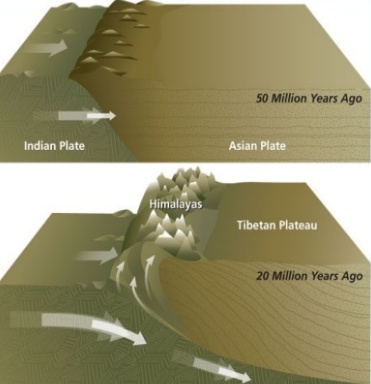
    About 40 to 50 million years ago, two large landmasses, India and Eurasia, driven by plate movement, collided. As a result, the sediments accumulated in Tethys Sea (brought by rivers) were compressed, squeezed and series of folds were formed, one behind the other, giving birth to folded mountains of the Himalayas.

    Recent studies show that India is still moving northwards at the rate of 5cm/year and crashing into the rest of Asia, thereby constantly increasing the height of Himalayas.

    The North-South division of the Himalayas

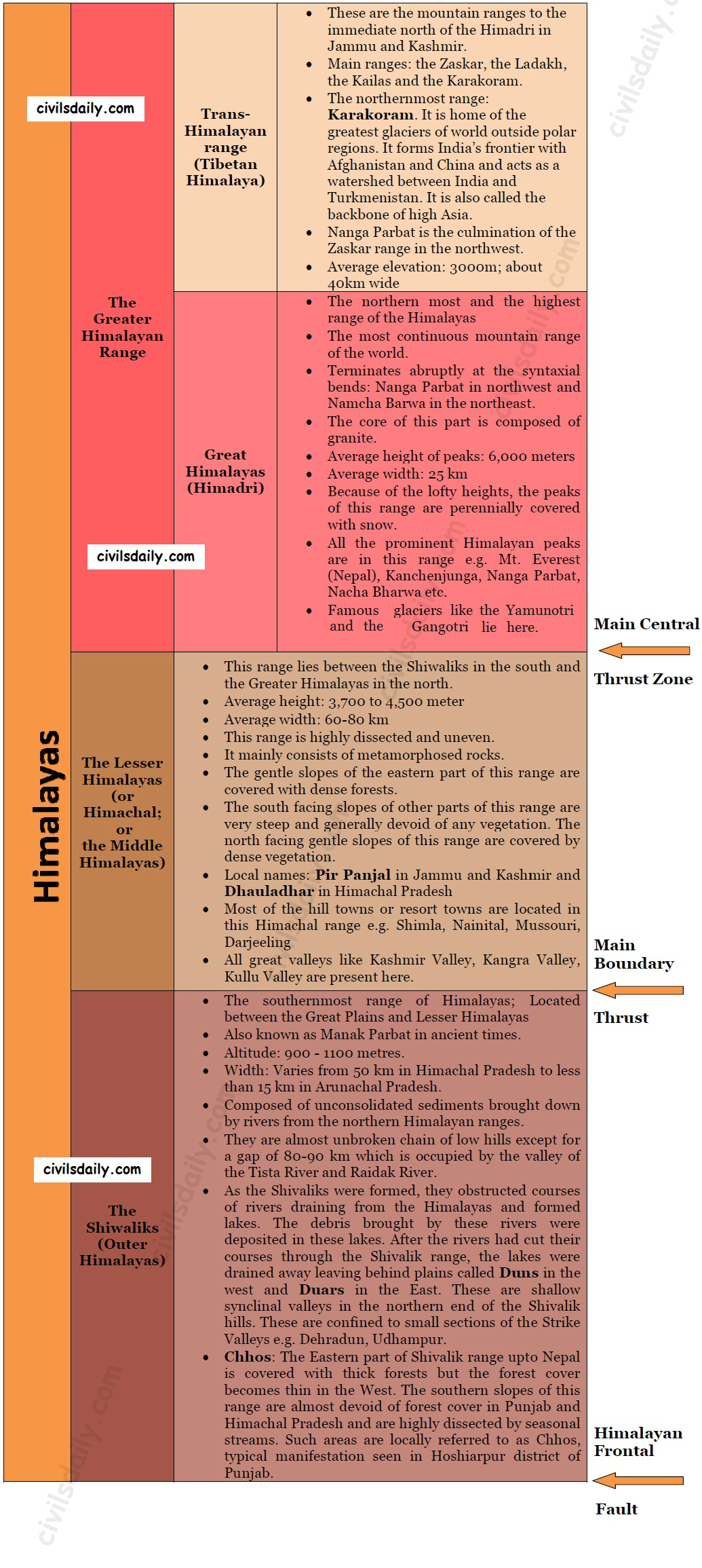
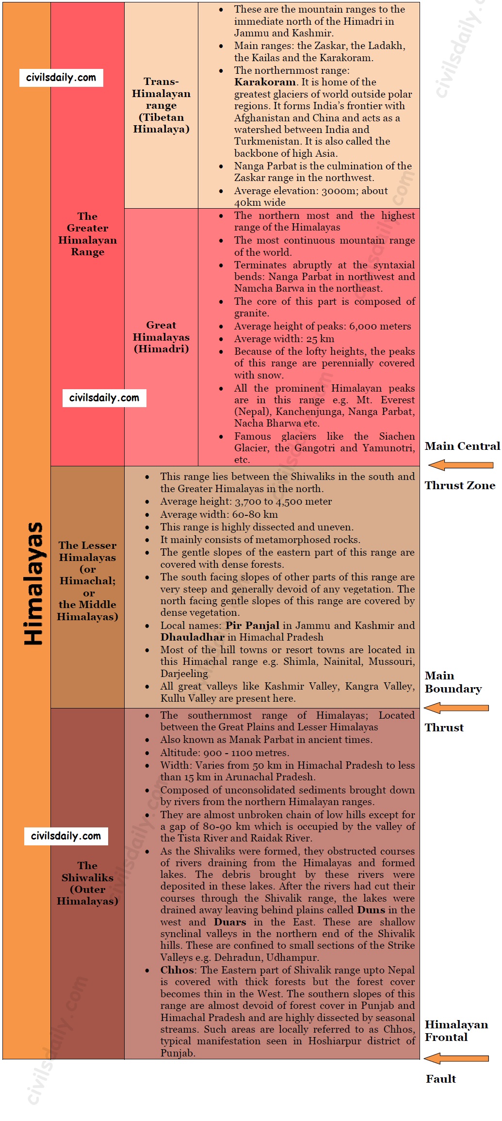
    The Himalayas consist of a series of parallel mountain ranges:

    1. The Greater Himalayan range, which includes:
      • The Great Himalayas(Himadri), and
      • The Trans-Himalayan range
    2. The Lesser Himalayas (or Himachal), and
    3. The Outer Himalayas (or Shiwalik).

    • Formation of these ranges: The Himadri and Himachal ranges of the Himalayas have been formed much before the formation of Siwalik range. The rivers rising in the Himadri and Himachal ranges brought gravel, sand and mud along with them, which was deposited in the rapidly shrinking Tethys Sea. In the course of time, the earth movements caused the folding of these relatively fresh deposits of sediments, giving rise to the least consolidated Shiwalik range.
    • Characteristic Features:
      • Notice in the map shown above that the Himalayas form an arcuate curve which is convex to the south. This curved shape of the Himalayas is attributed to the maximum push offered at the two ends on the Indian peninsula during its northward drift. In the north-west, it was done by Aravalis and in the Northeast by the Assam ranges.
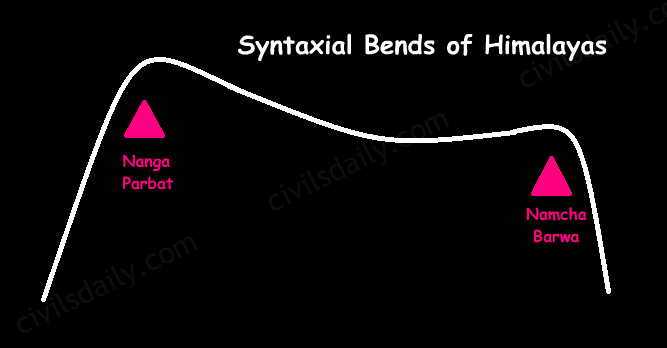
      • Syntaxis/ Syntaxial bends: The gently arching ranges of the Himalayan mountains on their Western and Eastern extremities are sharply bent southward in deep Knee-bend flexures that are called syntaxial bends. On both the ends, the great mountains appear to bend around a pivotal point. The western point is situated south of the Pamir where the Karakoram meets the Hindu Kush. A similar sharp, almost hairpin bend occurs on the eastern limit of Arunachal Pradesh where the strike of the mountain changes sharply from the Easterly to Southerly trend. Besides these two major bends, there are a number of minor syntaxial bends in other parts of Himalayas.

        Syntaxial Bends of Himalayas

      • The Himalayas are wider in the west than in the east. The width varies from 400 km in Kashmir to 150 km in Arunachal Pradesh. The main reason behind this difference is that the compressive force was more in the east than in the west. That is why high mountain peaks like Mount Everest and Kanchenjunga are present in the Eastern Himalayas.
      • The ranges are separated by deep valleys creating a highly dissected topography.
      • The southern slopes of the Himalayas facing India are steeper and those facing the Tibetan side are generally gentler.
    • Let’s take up these Himalayan mountain ranges one by one:

      The Himalayan Ranges | the Greater Himalayan Range, the Lesser Himalayas, the Shivaliks

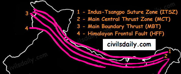
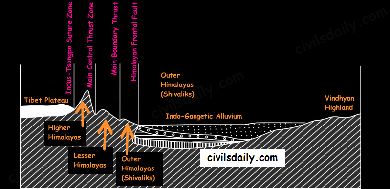
      Indus-Tsangpo Suture Zone: It represents a belt of tectonic compression caused by the underthrusting of the Indian shield/ plate against the Tibetan mass. It marks the boundary between the Indian and Eurasian plates. The suture zone stretches from the North-Western Himalayan syntaxis bordering the Nanga Parbat to the East as far as the Namche Barwa Mountain. The Karakoram Range and the Ladakh plateau lie to the north of ITSZ and originally formed a part of the European plate. Main Central Thrust Zone: This separates the Higher Himalayas in the north from lesser Himalayas in the south. It has played an important role in the tectonic history of these mountains. Main Boundary Thrust: It is a reverse fault of great dimensions which extends all the way from Assam to Punjab and serves to separate the outer Himalayas from the lesser Himalayas.Himalayan Frontal Fault: It is a series of reverse faults that demarcates the boundary of the Shivalik from of the Himalayan province from the alluvial expanse of the Indo-Gangetic plains.

    Major Faults of the Himalayas – ITSZ, MCT, MBT, HFF
    The Himalayan Complex: A Cross-sectional View

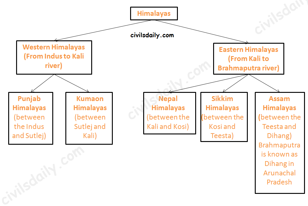
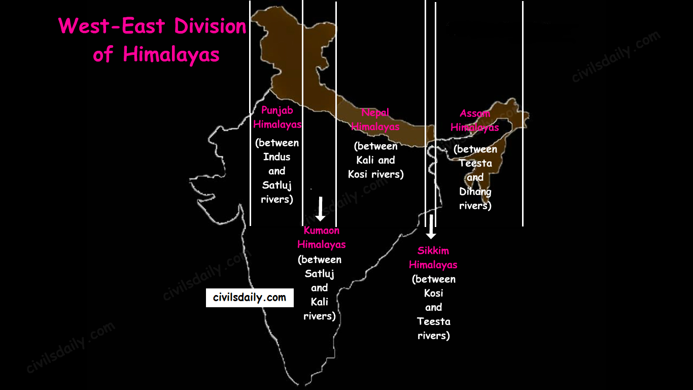
    Besides the longitudinal divisions, the Himalayas have been divided on the basis of regions from west to east:

    These divisions have been demarcated by river valleys:

    The Regional Divisions of Himalayas – the Western and Eastern Himalayas.
    1. Punjab Himalayas:
      • A large portion of Punjab Himalayas is in Jammu and Kashmir and Himachal Pradesh. Hence they are also called the Kashmir and Himachal Himalaya.
      • Major ranges: Karakoram, Ladakh, Pir Panjal, Zaskar and Dhaola Dhar.
      • The general elevation falls westwards.
      • The Kashmir Himalayas are also famous for Karewa formations.
        • ‘Karewas’ in Kashmiri language refer to the lake deposits, found in the flat-topped terraces of the Kashmir valley and on the flanks of the Pir Panjal range.
        • These deposits consist of clays, silts and sands, these deposits also show evidence of glaciation.
        • The occurrence of tilted beds of Karewas at the altitudes of 1500-1800m on the flanks of the Pir Panjal strongly suggests that the Himalayas were in process of uplift as late as Pliocene and Pleistocene (1.8mya to 10kyears ago)
        • Karewas are famous for the cultivation of Zafran, a local variety of saffron.
    2. Kumaon Himalayas
    3. Nepal Himalayas:
      • Tallest section of Himalayas
    4. Sikkim Himalayas:
      • Teesta river originates near Kanchenjunga
      • Jelep la pass- tri-junction of India- China-Bhutan
    5. Assam Himalayas:
      • The Himalayas are narrower in this region and Lesser Himalayas lie close to Great Himalayas.
      • Peaks: Namcha Barwa, Kula Kangri
      • Bengal ‘Duars’
      • Diphu pass- tri-junction of India- China-Myanmar
      • The Assam Himalayas show a marked dominance of fluvial erosion due to heavy rainfall.
    The West-East Division of Himalayas

    Glaciers and Snowline:

    Snowline: The lower limit of perpetual snow is called the ‘snowline’. The snowline in the Himalayas has different heights in different parts, depending on latitude, altitude, amount of precipitation, moisture, slope and local topography.

    1. The snowline in the Western Himalaya is at a lower altitude than in the Eastern Himalaya. E.g. while the glaciers of the Kanchenjunga in the Sikkim portion hardly move below 4000m, and those of Kumaon and Lahul to 3600m, the glaciers of the Kashmir Himalayas may descend to 2500m above the sea level.

    • It is because of the increase in latitude from 28°N in Kanchenjunga to 36°N in the Karakoram (Lower latitude —> warmer temperatures —> higher snowline).
    • Also, the Eastern Himalayas rise abruptly from the planes without the intervention of High ranges.
    • Though the total precipitation is much less in the western Himalayas, it all takes place in the form of snow.

    2. In the Great Himalayan ranges, the snowline is at a lower elevation on the southern slopes than on the northern slopes. This is because the southern slopes are steeper and receive more precipitation as compared to the northern slopes.

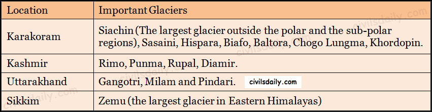
    Glaciers: The main glaciers are found in the Great Himalayas and the Trans-Himalayan ranges (Karakoram, Ladakh and Zaskar). The Lesser Himalayas have small glaciers, though traces of large glaciers are found in the Pir Panjal and Dhauladhar ranges. Some of the important glaciers are:

    Important Glaciers and their Locations

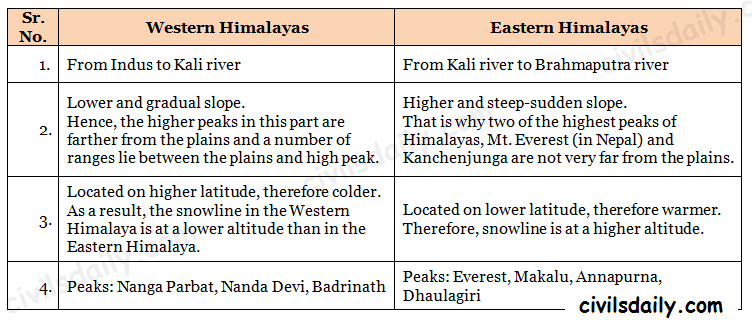
    Key differences between the Eastern and Western Himalayas:

    Key Difference between the Western and Eastern Himalayas.

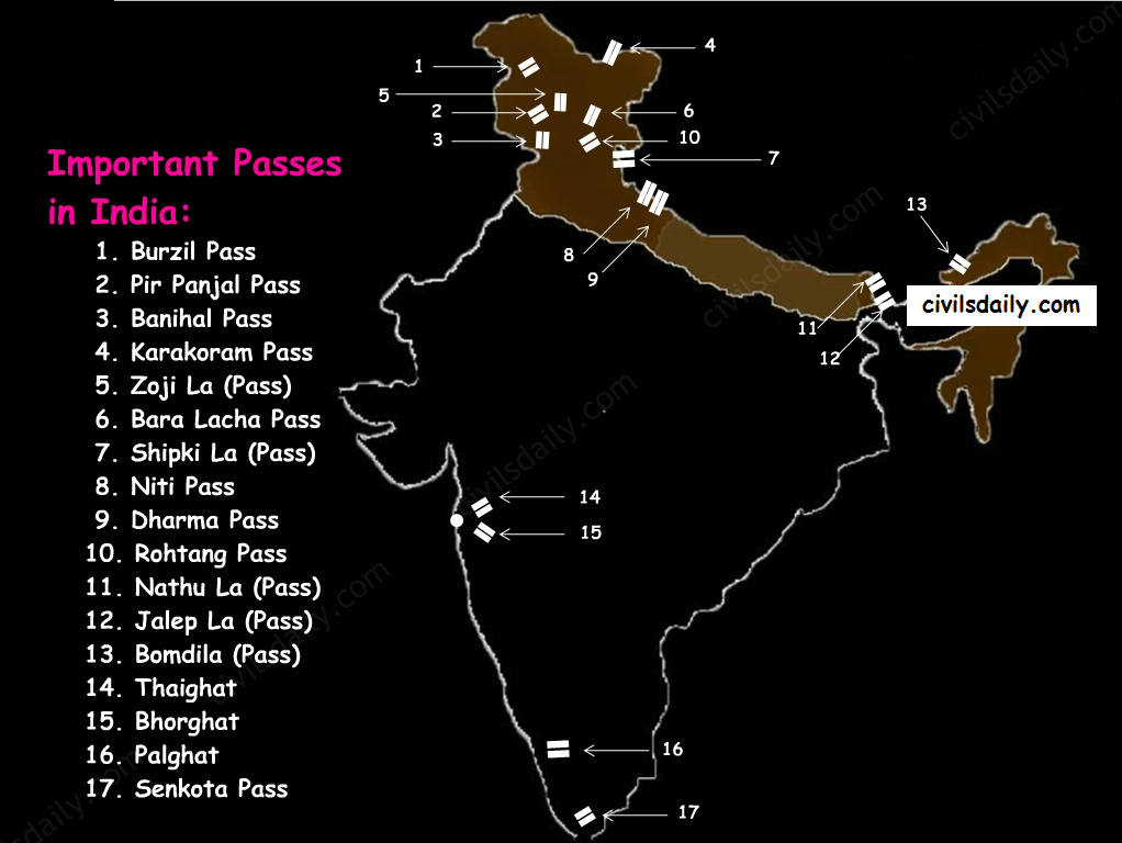
    Important Passes in India:

    A pass is a narrow gap in a mountain range which provides a passageway through the barrier.

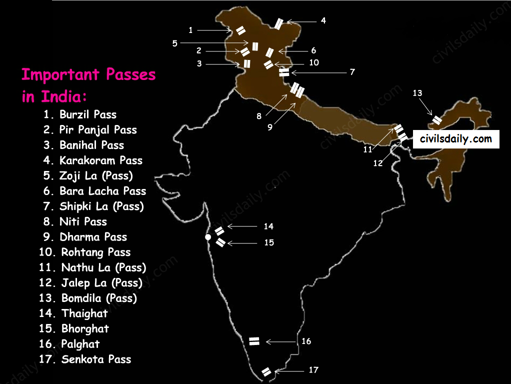
    Important Passes in India
    1. Pir Panjal Pass – It provides the shortest and the easiest metal road between Jammu and the Kashmir Valley. But this route had to be closed down as a result of partition of the subcontinent.
    2. Banihal Pass – It is in Jammu and Kashmir. The road from Jammu to Srinagar transversed Banihal Pass until 1956 when Jawahar Tunnel was constructed under the pass. The road now passes through the tunnel and the Banihal Pass is no longer used for road transport.
    3. Zoji La (Pass) – It is in the Zaskar range of Jammu and Kashmir. The land route from Srinagar to Leh goes through this pass.
    4. Shipki La (Pass) – It is in Himachal Pradesh. The road from Shimla to Tibet goes through this pass. The Satluj river flows through this pass.
    5. Bara Lacha Pass – It is also in Himachal Pradesh. It links Mandi and Leh by road.
    6. Rohtang Pass – It is also in Himachal Pradesh. It cuts through the Pir Panjal range. It links Manali and Leh by road.
    7. Niti Pass – It is in Uttarakhand. The road to the Kailash and the Manasarovar passes through it.
    8. Nathu La (Pass) – It is in Sikkim. It gives way to Tibet from Darjeeling and Chumbi valley. The Chumbi river flows through this pass.
    9. Jalep La (Pass) – At the tri-junction of India- China-Bhutan. The Teesta river has created this pass.

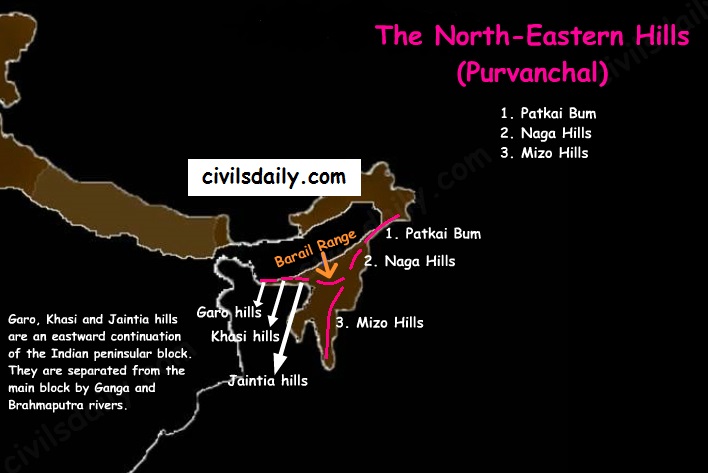
    B) The North-Eastern Hills and Mountains

    The North-Eastern Hills (Purvanchal): Patkai Bum, Naga Hills, Mizo Hills

    The Brahmaputra marks the eastern border of Himalayas. Beyond the Dihang gorge, the Himalayas bend sharply towards the south and form the Eastern hills or Purvanchal.

    • These hills run through the northeastern states of India.
    • These hills differ in scale and relief but stem from the Himalayan orogeny.
    • They are mostly composed of sandstones (i.e. Sedimentary rocks).
    • These hills are covered with dense forests.
    • Their elevation decreases from north to south. Although comparatively low, these hill ranges are rather forbidding because of the rough terrain, dense forests and swift streams.
    • Purvanchal hills are convex to the west.
    • These hills are composed of:
      • Patkai Bum – Border between Arunachal Pradesh and Myanmar
      • Naga Hills
      • Manipuri Hills – Border between Manipur and Myanmar
      • Mizo Hills.
    • Patkai Bum and Naga Hills form the watershed between India and Myanmar.
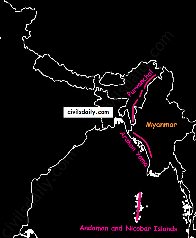
    • Extension of Purvanchal continues in Myanmar as Arakan Yoma –then Andaman and Nicobar Islands.
    Arakan Yoma – An Extension of Purvanchal in Myanmar

    The importance of Himalayan Region:

    1. Climatic Influence – The altitude of the Himalayas, their sprawl and extension intercept the summer monsoon. They also prevent the cold Siberian air masses from entering into India.
    1. Defence
    2. Source of perennial rivers
    3. Source of fertile soils
    4. Generation of hydroelectricity
    5. Forest wealth
    6. Orchards
    7. Minerals – The Himalayan region is rich in minerals e.g. gold, silver, copper, lead etc. are known to occur. Coal is found in Kashmir. But at the present level of technological advancement, it is not possible to extract these minerals. Also, it is not economically viable.
    8. Tourism
    9. Pilgrimage

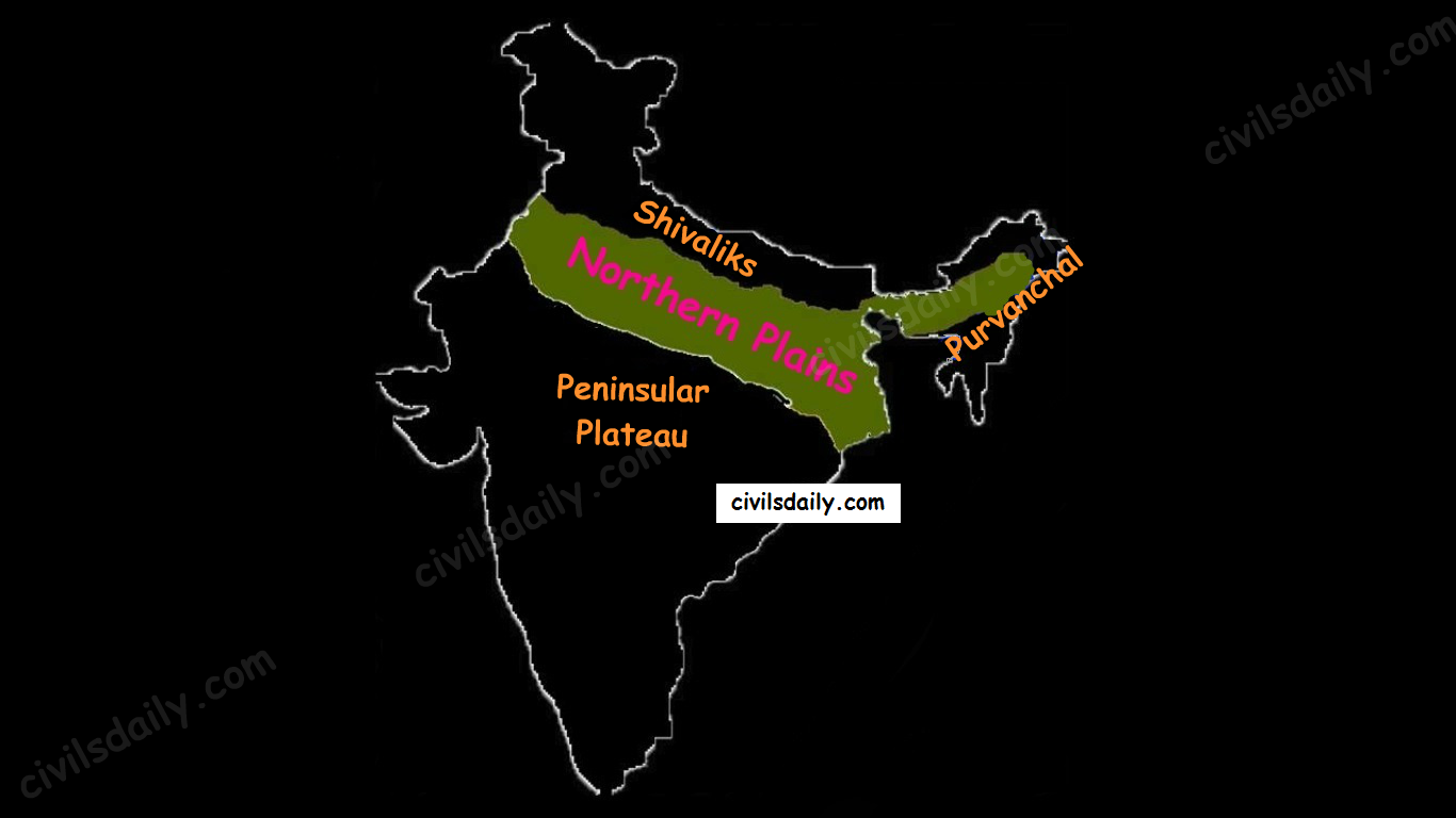
    NORTHERN PLAINS

    Location and Extent:

    Northern plains are the youngest physiographic feature in India. They lie to the south of the Shivaliks, separated by the Himalayan Frontal Fault (HFF). The southern boundary is a wavy irregular line along the northern edge of the Peninsular India. On the eastern side, the plains are bordered by the Purvanchal hills.

    The Physiographic Divisions of India: the Northern Plains

    Formation of Northern Plains:

    Due to the uplift of the Himalayas in the Tethys Sea, the northern part of the Indian Peninsula got subsided and formed a large basin.

    northern-plains
    Source

    That basin was filled with sediments from the rivers which came from the mountains in the north and from the peninsula in the south. These extensive alluvial deposits led to the formation of the northern plains of India.

    Chief Characteristics:

    • The northern plain of India is formed by three river systems, i.e. the Indus, the Ganga and the Brahmaputra; along with their tributaries.
    • The northern plains are the largest alluvial tract of the world. These plains extend approximately 3200 km from west to east.
    • The average width of these plains varies between 150 and 300 km. In general, the width of the northern plains increases from east to west (90-100km in Assam to about 500km in Punjab).
    • The exact depth of alluvium has not yet been fully determined. According to recent estimates, the average depth of alluvium in the southern side of the plain varies between 1300-1400m, while towards the Shiwaliks, the depth of alluvium increases. The maximum depth of over 8000m has been reached in parts of Haryana.
    • The extreme horizontality of this monotonous plain is its chief characteristic (200m – 291m). The highest elevation of 291 m above mean sea level near Ambala forms a watershed between the Indus system and Ganga system).
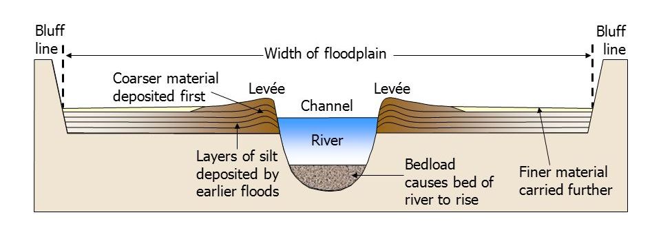
    • The monotony of the physical landscape is broken at the micro-level by the river bluffs, levees etc.
      • [Floodplain – That part of a river valley, adjacent to the channel, over which a river flows in times of a flood.
      • Levee – An elevated bank flanking the channel of the river and standing above the level of the flood plain.
      • Bluff – A river cut cliff or steep slope on the outside of a meander. A line of bluffs often marks the edge of a former floodplain.]
    slide_34
    Source

    Physiographic Divisions of the Northern Plains:

    From the north to the south, the northern plains can be divided into three major zones:

    1. The Bhabar
    2. The Tarai
    3. The alluvial plains.

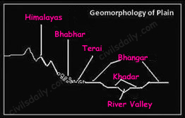
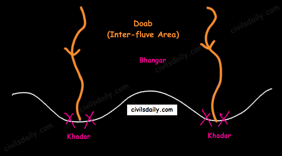
    The alluvial plains can be further divided into the Khadar and the Bhangar as illustrated below:

    Geomorphology of the Northern Plains

    Let’s understand these divisions one by one:

    Bhabar:

    • Bhabar is a narrow belt (8-10km wide) which runs in the west-east direction along the foot of the Himalayas from the river Indus to Teesta.
      alluvial-fan

      Source

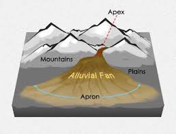
    • Rivers which descend from the Himalayas deposit their load along the foothills in the form of alluvial fans.
    • These fans consisting of coarser sediments have merged together to build up the piedmont plain/the Bhabar.
    • The porosity of the pebble-studded rock beds is very high and as a result, most of the streams sink and flow underground. Therefore, the area is characterized by dry river courses except in the rainy season.
    • The Bhabar track is not suitable for cultivation of crops. Only big trees with large roots thrive in this region.
    • The Bhabar belt is comparatively narrow in the east and extensive in the western and north-western hilly region.

    Tarai:

    • It is a 10-20 km wide marshy region in the south of Bhabar and runs parallel to it.
    • The Tarai is wider in the eastern parts of the Great Plains, especially in the Brahmaputra valley due to heavy rainfall.
    • It is characterized by the re-emergence of the underground streams of the Bhabar belt.
    • The reemerged water transforms large areas along the rivers into badly drained marshy lands.
    • Once covered with dense forests, most of the Tarai land (especially in Punjab, Uttar Pradesh and Uttarakhand) has been reclaimed and turned into agricultural land over a period of time.

    Bhangar:

    • It is the older alluvium along the river beds forming terraces higher than the flood plain.
    • Dark in colour, rich in humus content and productive.
    • The soil is clayey in composition and has lime modules (called kankar)
    • Found in doabs (inter-fluve areas)
    • ‘The Barind plains’ in the deltaic region of Bengal and the ‘bhur formations’ in the middle Ganga and Yamuna doab are regional variations of Bhangar. [Bhur denotes an elevated piece of land situated along the banks of the Ganga river especially in the upper Ganga-Yamuna Doab. This has been formed due to accumulation of wind-blown sands during the hot dry months of the year]
    • In relatively drier areas, the Bhangar also exhibits small tracts of saline and alkaline efflorescence known as ‘Reh’, ‘Kallar’ or ‘Bhur’. Reh areas have spread in recent times with an increase in irrigation (capillary action brings salts to the surface).
    • May have fossil remains of even those plants and animals which have become extinct.

    Khadar:

    • Composed of newer alluvium and forms the flood plains along the river banks.
    • Light in colour, sandy in texture and more porous.
    • Found near the riverbeds.
    • A new layer of alluvium is deposited by river flood almost every year. This makes them the most fertile soils of Ganges.
    • In Punjab, the Khadar rich flood plains are locally known as ‘Betlands’ or ‘Bets’.
    • The rivers in Punjab-Haryana plains have broad flood plains of Khadar flanked by bluffs, locally known as Dhayas. These bluffs are as high as 3metres.

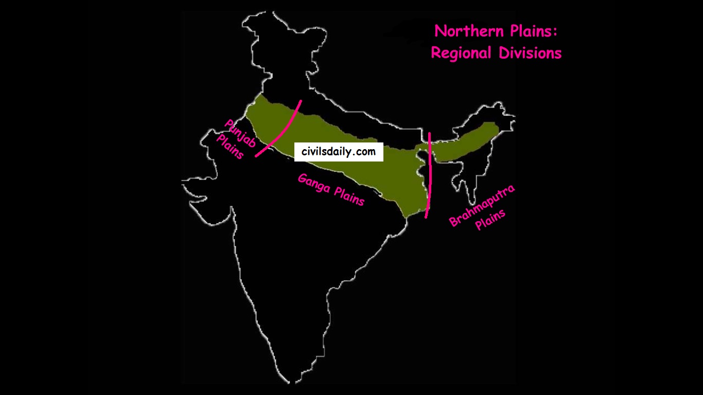
    Northern Plain: Regional Divisions

    The Regional Divisions of the Northern Plains: Punjab, Ganga and the Brahmaputra Plains.
    1. Punjab Plains:
    • The Punjab plains form the western part of the northern plain.
    • In the east, the Delhi-Aravalli ridge separates it from the Ganga plains.
    • This is formed by the Indus and its tributaries; like Jhelum, Chenab, Ravi, Beas and Sutlej. A major portion of these plains is in Pakistan.
    • It is divided into many Doabs (do-“two” + ab- “water or river” = “a region or land lying between and reaching to the meeting of the two rivers”).
      Khadar and Bhangar
    • Important features:
      • Khadar rich flood plains known as ‘Betlands’ or ‘Bets’.
      • The rivers in Punjab-Haryana plains have broad flood plains of Khadar flanked by bluffs, locally known as Dhayas.
      • The northern part of this plane adjoining the Shivalik hills has been heavily eroded by numerous streams, which are called Chhos.
      • The southwestern parts, especially the Hisar district is sandy and characterized by shifting sand-dunes.
    1. Ganga Plains:
    • The Ganga plains lie between the Yamuna catchment in the west to the Bangladesh border in the East.
    • The lower Ganga plain has been formed by the down warping of a part of Peninsular India between Rajmahal hills and the Meghalaya plateau and subsequent sedimentation by the Ganga and Brahmaputra rivers.
    • The main topographical variations in these plains include Bhabar, Tarai, Bhangar, Khadar, levees, abandoned courses etc.
    • Almost all the rivers keep on shifting their courses making this area prone to frequent floods. The Kosi river is very notorious in this respect. It has long been called the ‘Sorrow of Bihar’.
    • The northern states, Haryana, Delhi, UP, Bihar, part of Jharkhand and West Bengal in the east lie in the Ganga plains.
    • The Ganga-Brahmaputra delta: the largest delta in the world. A large part of the coastal delta is covered tidal forests called Sunderbans. Sunderbans, the largest mangrove swamp in the world gets its name from the Sundari tree which grows well in marshland. It is home to the Royal Tiger and crocodiles.
    1. Brahmaputra Plains:
    • This plain forms the eastern part of the northern plain and lies in Assam.
    • Its western boundary is formed by the Indo-Bangladesh border as well as the boundary of the lower Ganga Plain. Its eastern boundary is formed by Purvanchal hills.
    • The region is surrounded by high mountains on all sides, except on the west.
    • The whole length of the plain is traversed by the Brahmaputra.
    • The Brahmaputra plains are known for their riverine islands (due to the low gradient of the region) and sand bars.
    • The innumerable tributaries of the Brahmaputra river coming from the north form a number of alluvial fans. Consequently, the tributaries branch out in many channels giving birth to river meandering leading to the formation of bill and ox-bow lakes.
    • There are large marshy tracts in this area. The alluvial fans formed by the coarse alluvial debris have led to the formation of terai or semi-terai conditions.

    Significance of this region:

    • The plains constitute less than one-third of the total area of the country but support over 40 percent of the total population of the country.
    • Fertile alluvial soils, flat surface, slow-moving perennial rivers and favourable climate facilitate an intense agricultural activity.
    • The extensive use of irrigation has made Punjab, Haryana and western part of Uttar Pradesh the granary of India (Prairies are called the granaries of the world).
    • Cultural tourism: Several sacred places and centres of pilgrimage are situated in these plains e.g. Haridwar, Amritsar, Varanasi, Allahabad, Bodh Gaya etc.
    • The sedimentary rocks of plains have petroleum and natural gas deposits.
    • The rivers here have very gentle gradients which make them navigable over long distances.


    PENINSULAR PLATEAU

    A. Location and Extent

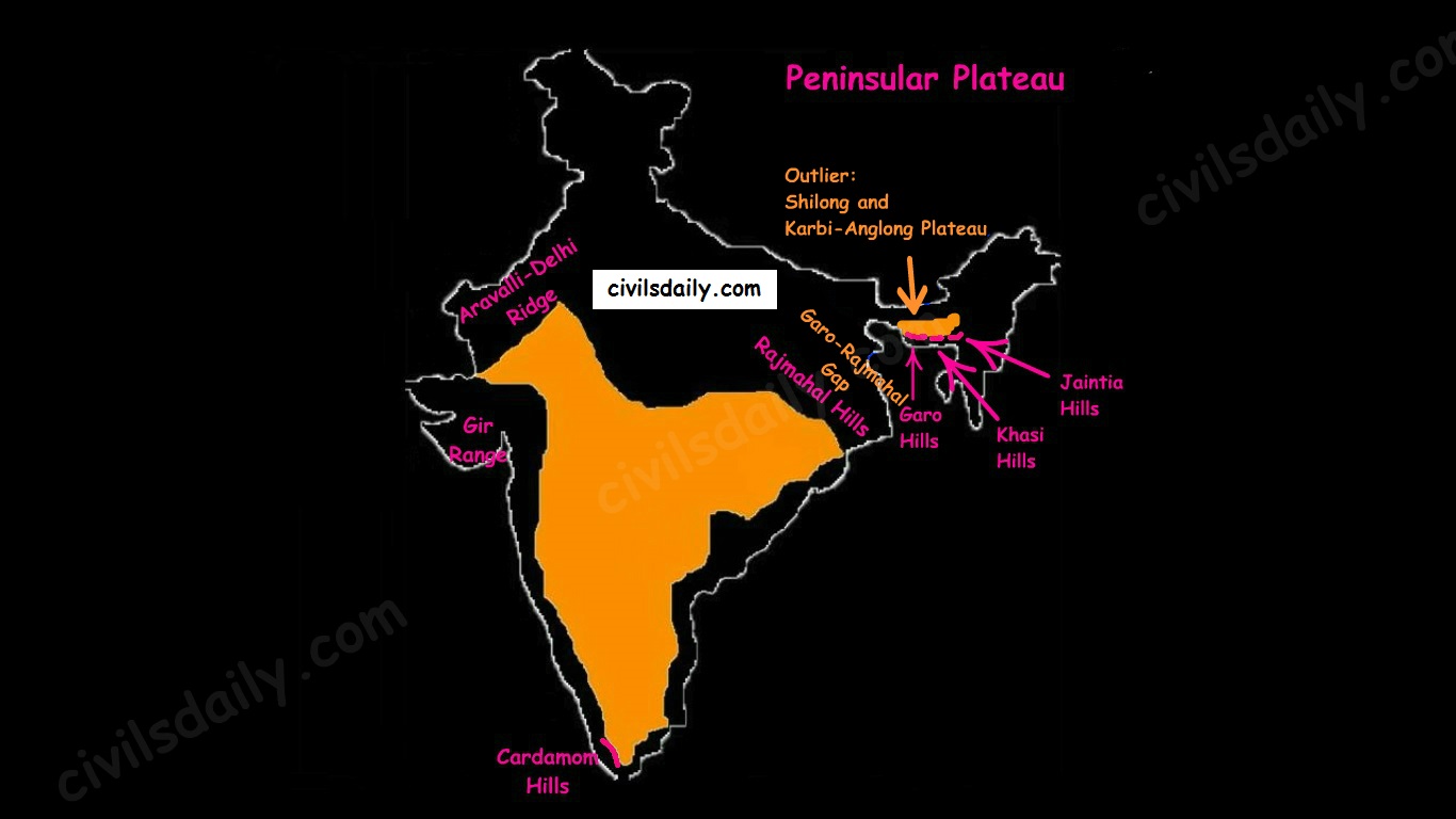
    • The Peninsular Plateau lies to the south of the Northern Plains of India.
    • It is bordered on all sides by the hill ranges:
    • Delhi ridge in the north-west (extension of Aravalis),
    • the Rajmahal Hills in the east,
    • Gir range in the west, and
    • the Cardamom Hills in the south constitute the outer extent of the peninsular plateau.
    The Physiographic Divisions of India | The Peninsular Plateau
    • Outlier:
      • Shillong and Karbi-Anglong plateau.

    Note: Kutchch Kathiawar region – The region, though an extension of Peninsular plateau (because Kathiawar is made of the Deccan Lava and there are tertiary rocks in the Kutch area), they are now treated as an integral part of the Western Coastal Plains as they are now levelled down.

    • The Garo-Rajmahal Gap:
      • The two disconnected outlying segments of the plateau region are seen in the Rajmahal and Garo-Khasi Jaintia hills.
      • It is believed that due to the force exerted by the northeastward movement of the Indian plate at the time of the Himalayan origin, a huge fault was created between the Rajmahal hills and the Meghalaya plateau
      • Later, this depression got filled up by the deposition activity of the numerous rivers.
      • As a result, today the Meghalaya and Karbi Anglong plateau stand detached from the main Peninsular Block.

    Geological History and Features:

    The peninsular plateau is a tableland which contains igneous and metamorphic rocks. It is one of the oldest and the most stable landmass of India.

    In its otherwise stable history, the peninsula has seen a few changes like:

    1. Gondwana Coal Formation.
    2. Narmada-Tapi rift valley formation.
    3. Basalt Lava eruption on Deccan plateau:

    During its journey northward after breaking off from the rest of Gondwana, the Indian Plate passed over a geologic hotspot, the Réunion hotspot, which caused extensive melting underneath the Indian Craton. The melting broke through the surface of the craton in a massive flood basalt event, creating what is known as the Deccan Traps (Its various features have been discussed in the later portion of the article).

    Chief Characteristics:

    The entire peninsular plateau region is an aggregation of several smaller plateaus and hill ranges interspersed with river basins and valleys. The Chhattisgarh plain occupied by the dense Dandakaranya forests is the only plain in the peninsula.

    1. General elevation and flow of rivers:

    • The average elevation is 600-900 metres.
    • The general elevation of the plateau is from the west to the east, which is also proved by the pattern of the flow of rivers.
    • Barring Narmada and Tapti all the major rivers lying to the south of the Vindhyas flow eastwards to fall into the Bay of Bengal.
    • The westward flow of Narmada and Tapi is assigned to the fact that they have been flowing through faults or rifts which were probably caused when the Himalayas began to emerge from the Tethys Sea of the olden times.

    2. Some of the important physiographic features of this region are:

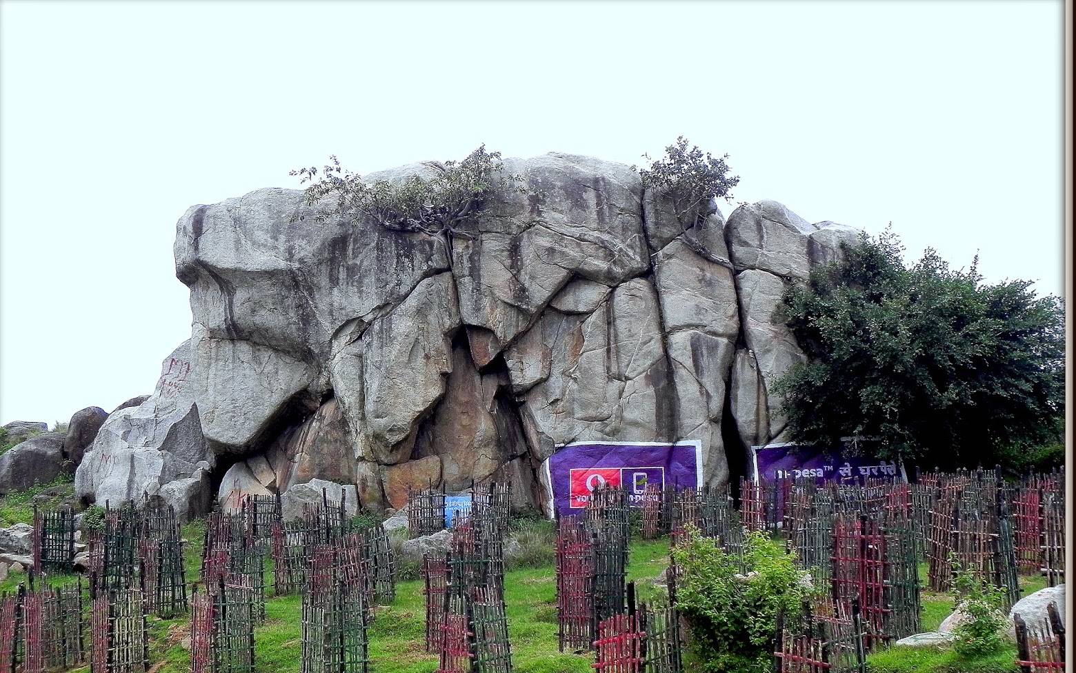
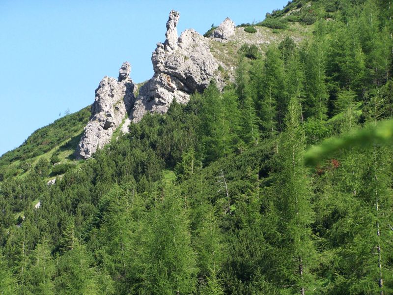
    • Tors – Prominent, isolated mass of jointed, weathered rock, usually granite.
    A granite tor near Ranchi
    A granite tor near Ranchi
    • Block Mountains and Rift Valleys:
    • Spurs: A marked projection of land from a mountain or a ridge
    spur
    Image Source
    • Bare rocky structures,
    • Series of hummocky hills and wall-like quartzite dykes offering natural sites for water storage.
    • Broad and shallow valleys and rounded hills
    • Ravines and gorges: The northwestern part of the plateau has a complex relief of ravines and gorges. The ravines of Chambal, Bhind and Morena are some of the well-known examples.

    3. The Deccan Traps:

    • One of the most important features of the peninsular plateau is the black soil area in the western and northwestern part of the plateau, which is known as the Deccan Trap.
    • From the end of the Cretacious until the beginning of the Eocene, numerous fissure-type eruptions took place in the north-western part of the Deccan plateau. It is believed that the lava outpourings were more than the mass comprising the present-day Himalayas.
    • It covers a major portion of the Maharashtra plateau and parts of Gujarat, northern Karnataka and Malwa plateau. Some parts of Tamil Nadu, Andhra Pradesh, UP, and Jharkhand have some outliers of Deccan trap.
    • Basalt is the main rock of the region.
    • The region has black cotton soil as a result of weathering of this lava material and this soil is one of the finest examples of the parent material controlled soils.

    Physiographic Divisions:

    On the basis of prominent relief features, the peninsular plateau can be divided into three broad groups:

    • The Central Highlands
    • The Deccan Plateau
    • The Northeastern Plateau.
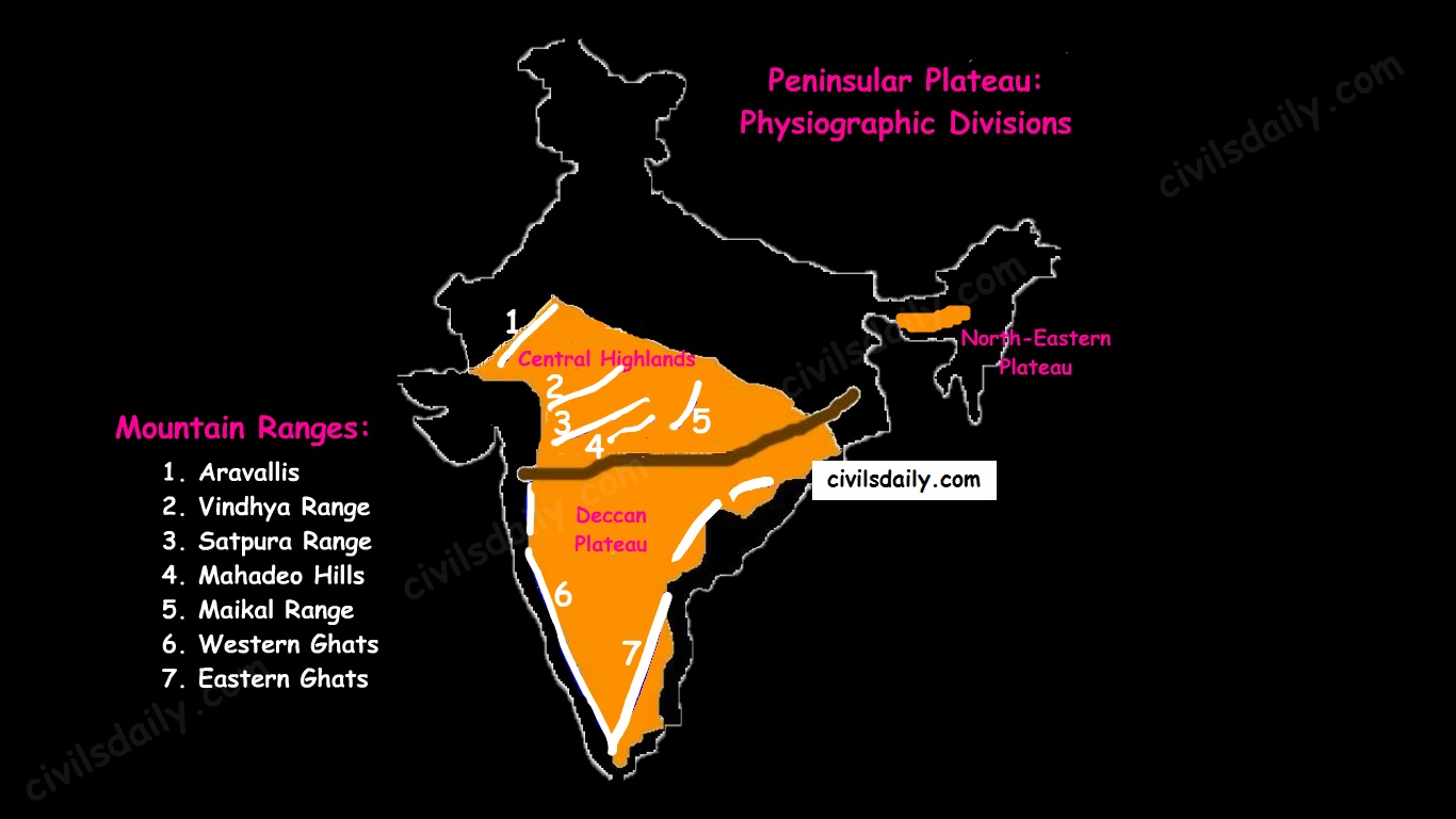
    Physiographic Divisions and Important Mountain Ranges of the Peninsular Plateau

    Let’s take up these divisions one by one:

    1. The Central Highlands

    • The northern segment of the peninsular plateau is known as the Central Highlands.
    • Location:
      1. North of Narmada river.
      2. They are bounded to the west by the Aravallis.
      3. Satpura ranges (formed by a series of scarped plateaus) lie in the South.
    • General Elevation: 700-1,000 m above the mean sea level and it slopes towards the north and northeastern directions.
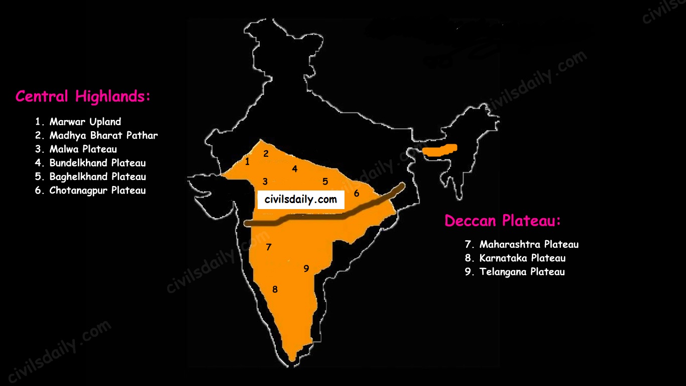
    • These highlands consist of the:
      1. Marwar upland – to the east of Aravallis in Rajasthan
        • A rolling plain carved by Banas river. [Rolling Plain: ‘Rolling plains’ are not completely flat; there are slight rises and fall in the landform. Ex: Prairies of USA]
        • The average elevation is 250-500 m above sea level.
      2. Madhya Bharat Pathar – to the east of Marwar upland.
      3. Malwa plateau – It lies in Madhya Pradesh between Aravali and Vindhyas. It is composed of the extensive lava flow and is covered with black soils.
      4. Bundelkhand plateau – It lies along the borders of UP and MP. Because of intensive erosion, semi-arid climate and undulating area, it is unfit for cultivation.
      5. Baghelkhand plateau – It lies to the east of the Maikal range.
      6. Chhotanagpur plateau – the northeast part of Peninsular plateau.
        • It Includes Jharkhand, parts of Chhattisgarh and West Bengal.
        • This plateau consists of a series of step-like sub-plateaus (locally called peatlands – high-level plateau). It is thus famous as the Patland plateau and known as Ruhr of India.
        • Rajmahal Hills are the northeastern projection of Chhota Nagpur Plateau.
        • It is a mineral-rich plateau.
    • The extension of the Peninsular plateau can be seen as far as Jaisalmer in the West, where it has been covered by the longitudinal sand ridges and crescent-shaped sand dunes called barchans.
    • This region has undergone metamorphic processes in its geological history, which can be corroborated by the presence of metamorphic rocks such as marble, slate, gneiss, etc.
    • Most of the tributaries of the river Yamuna have their origin in the Vindhyan and Kaimur ranges. Banas is the only significant tributary of the river Chambal that originates from the Aravalli in the west.
    Physiographic Divisions of the Peninsular Plateau – the Central Highlands and the Deccan Plateau

    2. The Deccan Plateau

    • The Deccan Plateau lies to the south of the Narmada River and is shaped as an inverted triangle.
    • It is bordered by:
      1. The Western Ghats in the west,
      2. The Eastern Ghats in the east,
      3. The Satpura, Maikal range and Mahadeo hills in the north.
    • It is volcanic in origin, made up of horizontal layers of solidified lava forming trap structure with step-like appearance. The sedimentary layers are also found in between the layers of solidified lava, making it inter–trapping in structure.
    • Most of the rivers flow from west to east.
    • The plateau is suitable for the cultivation of cotton; home to rich mineral resources and a source to generate hydroelectric power.
    • The Deccan plateau can be subdivided as follows:
      1. The Maharashtra Plateau – it has typical Deccan trap topography underlain by basaltic rock, the regur.
      2. The Karnataka Plateau (also known as Mysore plateau) – divided into western hilly country region of ‘Malnad’ and plain ‘Maidan’
      3. Telangana Plateau

    3. The Northeastern Plateau:

    • The Meghalaya (or Shillong) plateau is separated from peninsular rock base by the Garo-Rajmahal gap.
    • Shillong (1,961 m) is the highest point of the plateau.
    • The region has the Garo, Khasi, Jaintia and Mikir (Rengma) hills.
    • An extension of the Meghalaya plateau is also seen in the Karbi Anglong hills of Assam.
    • The Meghalaya plateau is also rich in mineral resources like coal, iron ore, sillimanite, limestone and uranium.
    • This area receives maximum rainfall from the south-west monsoon. As a result, the Meghalaya plateau has a highly eroded surface. Cherrapunji displays a bare rocky surface devoid of any permanent vegetation cover.

    Hill ranges of the peninsula:

    Most of the hills in the peninsular region are of the relict type (residual hills). They are the remnants of the hills and horsts formed many million years ago (horst: uplifted block; graben: subsided block).

    The plateaus of the Peninsular region are separated from one another by these hill ranges and various river valleys.

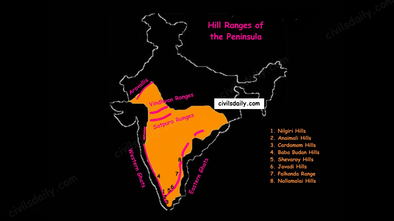
    Hill Ranges of the Peninsula

    1. The Aravalli Mountain Range:

    • It is a relic of one of the oldest fold mountains of the world.
    • Its general elevation is only 400-600 m, with few hills well above 1,000 m.
    • At present, it is seen as a discontinuous ridge from Delhi to Ajmer and rising up to 1722m (Gurushikhar peak in Mount Abu) and thence southward.
    • It is known as ‘Jarga’ near Udaipur and ‘Delhi Ridge’ near Delhi.
    • Dilwara Jain Temple, the famous Jain temple is situated on Mt. Abu.

    2. Vindhyan Ranges:

    • They rise as an escarpment running parallel to the Narmada-Son valley.
    • General elevation: 300 to 650 m.
    • Most of them are made up of sedimentary rocks of ancient ages.
    • They act as a watershed between Gangetic and peninsular river systems.

    3. Satpura ranges:

    • Satpura range is a series of seven mountains (‘Sat’ = seven and ‘pura’ = mountains).
    • The seven mountain ranges or folds of Satpura’s are:
      • Maikal Hills
      • Mahadeo Hills near Pachmarhi
      • Kalibhit
      • Asirgarh
      • Bijagarh
      • Barwani
      • Arwani which extends to Rajpipla Hills in Eastern Gujarat.
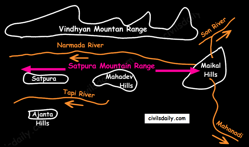
    • Satpura ranges run parallel between Narmada and Tapi, parallel to Maharashtra-MP border.
    • Dhupgarh (1,350 m) near Pachmarhi on Mahadev Hills is the highest peak of the Satpura Range.
    • Amarkantak (1,127 m) is another important peak. Amarkantak is the highest peak of the Maikal Hills from where two prominent rivers – the Narmada and the Son originate.
    • Note that three rivers originate from the three sides of Maikal hills (as shown in the following map) but, from Amarkantak, only two rivers (the Narmada and the Son) originate (and not Mahanadi).
    The Satpura Mountain Range

    4. Western and Eastern Ghats:

    • The Western Ghats:
      • These are a faulted part of the Deccan plateau running parallel from the Tapi valley to a little north of Kanyakumari (1600km). Their western slope is like an escarpment while eastern slope merges gently with the plateau.
      • Their average elevation is about 1,500 m with the height increasing from north to south.
    • The Eastern Ghats are in the form of residual mountains which are not regular but broken at intervals.
    • The Eastern and the Western Ghats meet each other at the Nilgiri hills.
    • A brief comparison between them:
    Differences between the Western and Eastern Ghats.
    A cross-sectional view through the Peninsular Plateau showing sharp relief contrast between the western and eastern margins

    Note: The Western Ghats are continuous and can be crossed through passes only. There are four main passes which have developed in the Western Ghats. These are:

    1. Thal Ghat – It links Nasik to Mumbai.
    2. Bhor Ghat – It links Mumbai to Pune.
    3. Pal Ghat – This pass is located between the Nilgiris and the Annamalai mountains. It is in Kerala and connects Kochi and Chennai.
    4. Senkota Pass – This pass located between the Nagercoil and the Cardamom hills links Thiruvananthapuram and Madurai.

    For the geographical location of these passes, see the following map:

    Important Passes in India

    Significance of the Peninsular Region:

    • Rich in mineral resources: The peninsular region of India is rich in both metallic and non-metallic minerals. About 98% of the Gondwana coal deposits of India are found in the peninsular region.
    • Agriculture: Black soil found in a substantial part of the peninsula is conducive for the cultivation of cotton, maize , citrus fruits etc. Some areas are also suitable for the cultivation of tea, coffee, groundnut etc.
    • Forest Products: Apart from teal, sal wood and other forest products, the forests of Western and Eastern Ghats are rich in medicinal plants and are home to many wild animals.
    • Hydel Power: many rivers, which have waterfalls. They help in the generation of hydroelectric power.
    • Tourism: There are numerous hill stations and hill resorts like Ooty, Mahabaleshwar, Khandala, etc.

    THE INDIAN DESERT

    The Indian desert is also known as the Thar Desert or the Great Indian Desert.

    Location and Extent:

    • Location – To the north-west of the Aravali hills.
    • It covers Western Rajasthan and extends to the adjacent parts of Pakistan.
    The Physiographic Divisions of India | The Indian Desert

    Geological History and Features

    • Most of the arid plain was under the sea from Permo-Carboniferous period and later it was uplifted during the Pleistocene age. This can be corroborated by the evidence available at wood fossils park at Aakal and marine deposits around Brahmsar, near Jaisalmer (The approximate age of the wood fossils is estimated to be 180 million years).
    • The presence of dry beds of rivers (eg Saraswati) indicates that the region was once fertile.
    • Geologically, the desert area is a part of the peninsular plateau region but on the surface, it looks like an aggradational plain.

    Chief Characteristics:

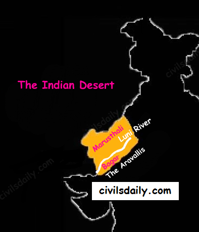
    • The desert proper is called the Marusthali (dead land) as this region has an arid climate with low vegetation cover. In general, the Eastern part of the Marushthali is rocky, while its western part is covered by shifting sand dunes.
    • Bagar: Bagar refers to the semi-desert area which is west of Aravallis. Bagar has a thin layer of sand. It is drained by Luni in the south whereas the northern section has a number of salt lakes.
    • The Rajasthan Bagar region has a number of short seasonal streams which originate from the Aravallis. These streams support agriculture in some fertile patches called Rohi.
    • Even the most important river ‘Luni’ is a seasonal stream. The Luni originates in the Pushkar valley of the Aravalli Range, near Ajmer and flows towards the southwest into the Rann of Kutch.
    • The region north of Luni is known as the Thali or sandy plain.
    • There are some streams which disappear after flowing for some distance and present a typical case of inland drainage by joining a lake or playa e.g. the Sambhar Lake. The lakes and the playas have brackish water which is the main source of obtaining salt.
    • Well pronounced desert land features:
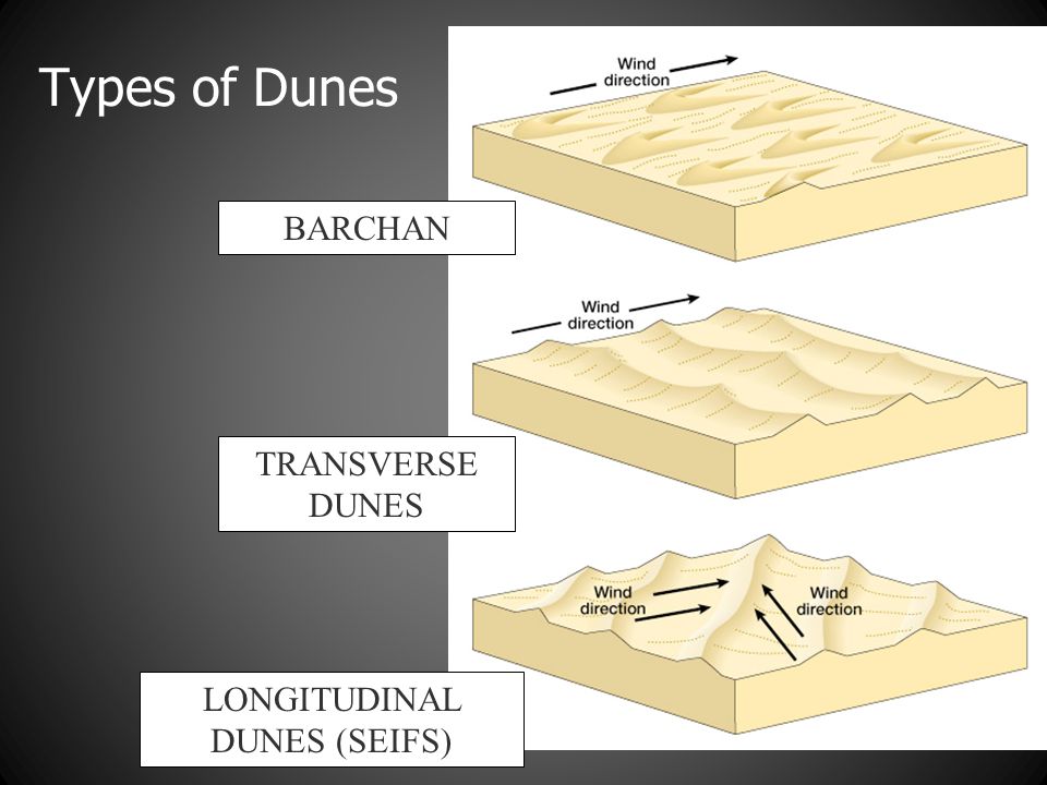
      • Sand dunes: It is a land of undulating topography dotted with longitudinal dunes, transverse dunes and barchans. [Barchan – A crescent-shaped sand dune, the horns of which point away from the direction of the dominant wind; Longitudinal dune – A sand dune with its crest running parallel to the direction of prevailing wind]
    sand-dunes
    Image Source
    • Mushroom rocks
    • Shifting dunes (locally called Dhrians)
    • Oasis (mostly in its southern part)


    THE COASTAL PLAINS

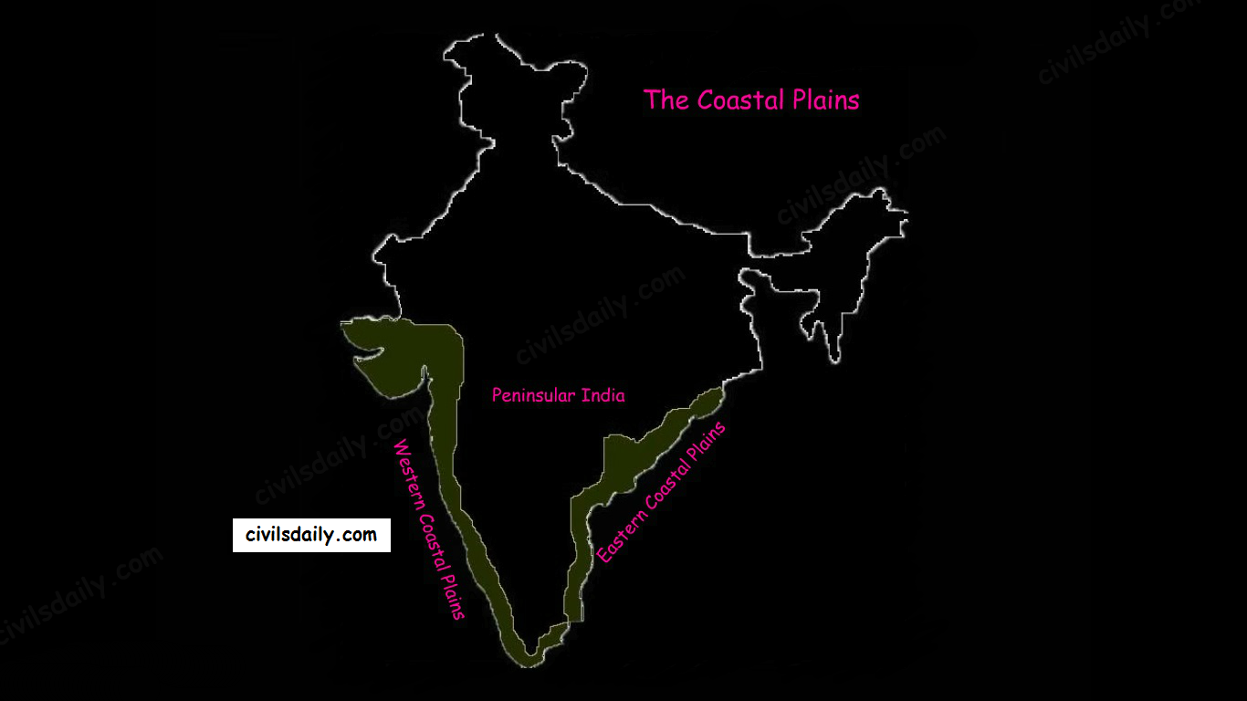
    Of the total coastline of India (7517 km), that of the peninsula is 6100 km between the peninsular plateau and the sea. The peninsular plateau of India is flanked by narrow coastal plains of varied width from north to south.

    The Physiographic Divisions of India | The Coastal Plains

    On the basis of the location and active geomorphologic processes, these can be broadly divided into two parts:

    • The western coastal plains
    • The eastern coastal plains.

    We now take them up one by one:

    The Western Coastal Plain

    1. Extent: The Western Coastal Plains are a thin strip of coastal plains with a width of 50 km between the Arabian Sea and the Western Ghats.

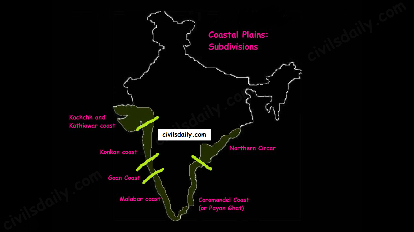
    2. Subdivisions: Extending from the Gujarat coast in the north to the Kerala coast in the south, the western coast may be divided into following divisions:

    • Kachchh and Kathiawar coast in Gujarat,
    • Konkan coast in Maharashtra,
    • Goan Coast in Karnataka, and
    • Malabar coast in Kerala

    Note: Kutch and Kathiawar, though an extension of Peninsular plateau (because Kathiawar is made of the Deccan Lava and there are tertiary rocks in the Kutch area), they are still treated as an integral part of the Western Coastal Plains as they are now levelled down.

    Subdivisions of the eastern and Western Coastal Plains

    3. A coastline of submergence: The western coastal plains are an example of the submerged coastal plain. It is believed that the city of Dwaraka which was once a part of the Indian mainland situated along the west coast is submerged underwater.

    4. Characteristic Features:

    • The western coastal plains are narrow in the middle and get broader towards north and south. Except for the Kachchh and Kathiawar coastal region, these are narrower than their eastern counterpart.
    • The coast is straight and affected by the South-West Monsoon winds over a period of six months. The western coastal plains are thus wetter than their eastern counterpart.
    • The western coast being more indented than the eastern coast provides natural conditions for the development of ports and harbours. Kandla, Mazagaon, JLN port Navha Sheva, Marmagao, Mangalore, Cochin, etc. are some of the important natural ports located along the west coast.
    • The western coastal plains are dotted with a large number of coves (a very small bay), creeks (a narrow, sheltered waterway such as an inlet in a shoreline or channel in a marsh) and a few estuaries. The estuaries, of the Narmada and the Tapi are the major ones.
    • The rivers flowing through this coastal plain do not form any delta. Many small rivers descend from the Western Ghats making a chain of waterfalls.
    • The Kayals – The Malabar coast has a distinguishing feature in the form of ‘Kayals’ (backwaters). These backwaters are the shallow lagoons or the inlets of the sea and lie parallel to the coastline. These are used for fishing, inland navigation and are important tourist spots. The largest of these lagoons is the Vembanad lake. Kochi is situated on its opening into the sea.

    The Eastern Coastal Plain

    1. Extent: The Eastern Coastal Plains is a strip of coastal plain with a width of 100 – 130 km between the Bay of Bengal and the Eastern Ghats

    2. Subdivisions: It can be divided into two parts:

    • Northern Circar: The northern part between Mahanadi and Krishna rivers. Additionally, the coastal tract of Odisha is called the Utkal plains.
    • Coromandel Coast (or Payan Ghat): The southern part between Krishna and Kaveri rivers.

    3. A coastline of emergence: The eastern coastal plain is broader and is an example of an emergent coast.

    4. Characteristic features:

    • The eastern coastal plains are wider and drier resulting in shifting sand dunes on its plains.
    • There are well-developed deltas here, formed by the rivers flowing eastward in to the Bay of Bengal. These include the deltas of the Mahanadi, the Godavari, the Krishna and the Kaveri.
    • Because of its emergent nature, it has less number of ports and harbours. The continental shelf extends up to 500 km into the sea, which makes it difficult for the development of good ports and harbours.
    • Chilika lake is an important feature along the eastern coast. It is the largest saltwater lake in India.

    Significance of the Coastal Plains region:

    1. These plains are agriculturally very productive. The western coast grows specialized tropical crops while eastern coasts witnessed a green revolution in rice.
    2. The delta regions of eastern coastal plains have a good network of canals across the river tributaries.
    3. Coastal plains are a source of salt, monazite (used for nuclear power) and mineral oil and gas as well as centres of fisheries.
    4. Although lacking in adequate natural harbours, with a number of major and minor ports, coastal plains are centres of commerce and have attracted dense human settlements.
    5. The coastal regions of India are noted for tourist centres, fishing and salt making.


    THE ISLANDS

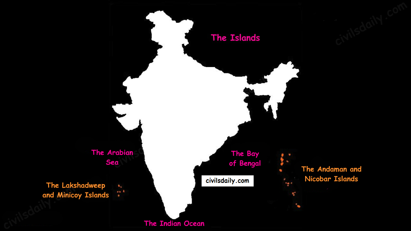
    There are two major island groups in India

    1. The island groups of Bay of Bengal: Andaman & Nicobar Islands
    2. The island groups of Arabian Sea: Lakshadweep and Minicoy Islands
    The Physiographic Divisions of India | The Islands

    Let’s take these up one by one:

    Andaman & Nicobar Islands:

    • Also called the emerald islands.
    • Location and Extent:
      • These are situated roughly between 6°N-14°N and 92°E -94°E.
      • The most visible feature of the alignment of these islands is their narrow longitudinal extent.
      • These islands extend from the Landfall Island in the north (in the Andamans) to the Indira Point (formerly known as Pygmalion Point and Parsons Point) in the south (In the Great Nicobar).
    • Origin: The Andaman and Nicobar islands have a geological affinity with the tertiary formation of the Himalayas, and form a part of its southern loop continuing southward from the Arakan Yoma.
    • The entire group of islands is divided into two broad categories:
      • The Andaman in the north, and
      • The Nicobar in the south.

    They are separated by a water body which is called the Ten-degree channel.

    • The Andaman islands are further divided into:
      • Great Andamans
        • North Andaman
        • Middle Andaman
        • South Andaman
      • Little Andaman

    Little Andaman is separated from the Great Andamans by the Duncan Passage.

    The Andaman and Nicobar Islands
    • Chief Characteristics:
      • These are actually a continuation of Arakan Yoma mountain range of Myanmar and are therefore characterized by hill ranges and valleys along with the development of some coral islands.
      • Some smaller islands are volcanic in origin e.g. the Barren island and the Narcondam Island. Narcondam is supposed to be a dormant volcano but Barren perhaps is still active.
      • These islands make an arcuate curve, convex to the west.
      • These islands are formed of granitic rocks.
      • The coastal line has some coral deposits and beautiful beaches.
      • These islands receive convectional rainfall and have an equatorial type of vegetation.
      • These islands have a warm tropical climate all year round with two monsoons.
      • The Saddle peak (North Andaman – 738 m) is the highest peak of these islands.
      • The Great Nicobar is the largest island in the Nicobar group and is the southernmost island. It is just 147 km away from the Sumatra island of Indonesia.

    Lakshadweep Islands:

    • These islands were earlier (before 1st November 1973) known as Laccadive, Minicoy and Amindivi Islands.
    • Location:
      • These are scattered in the Arabian Sea between 8°N-12°N and 71°E -74°E longitude.
      • These islands are located at a distance of 280 km-480 km off the Kerala coast.
    • Origin: The entire island group is built of coral deposits.
    • Important islands:
      • Amindivi and Cannanore islands in the north.
      • Minicoy (lies to the south of the nine-degree channel) is the largest island with an area of 453 sq. km.
    map_of_lakshadweep-en-svg
    Source
    • Chief Characteristics:
      • These consist of approximately 36 islands of which 11 are inhabited.
      • These islands, in general, have a north-south orientation (only Androth has an East-West orientation.
      • These islands are never more than 5 metres above sea level.
      • These islands have calcium-rich soils- organic limestones and scattered vegetation of palm species.
      • One typical feature of these islands is the formation of the crescentic reef in the east and a lagoon in the west.
      • Their eastern seaboard is steeper.
      • The Islands of this archipelago have storm beaches consisting of unconsolidated pebbles, shingles, cobbles and boulders on the eastern seaboard.
      • The islands form the smallest Union Territory of India.

    Other than the above mentioned two major groups, the important islands are:

    1. Majauli: in Assam. It is:
      1. The world’s largest freshwater (Brahmaputra river) island.
      2. India’s first island district
    2. Salsette: India’s most populous island. Mumbai city is located on this island.
    3. Sriharikota: A barrier island. On this island is located the satellite launching station of ISRO.
    4. Aliabet: India’s first off-shore oil well site (Gujarat); about 45 km from Bhavnagar, it is in the Gulf of Khambat.
    5. New Moore Island: in the Ganga delta. It is also known as Purbasha island. It is an island in the Sunderban deltaic region and it was a bone of contention between India and Bangladesh. In 2010, it was reported to have been completely submerged by the rising seawater due to Global warming.
    6. Pamban Island: lies between India and Sri Lanka.
    7. Abdul Kalam Island: The Wheeler Island near the Odisha coast was renamed as Abdul Kalam island in 2015. It is a missile launching station in the Bay of Bengal. The first successful land-to-land test of the Prithvi Missile was conducted from the mainland and it landed on the then uninhabited ‘Wheeler Island’ on November 30, 1993.
  • Preparing for IAS 2021? Schedule a call for optimal time management strategy

    Preparing for IAS 2021? Schedule a call for optimal time management strategy

    • Working Junta? If you are preparing for IAS 2021 and working simultaneously, we can help you design a timetable that fits right in your hectic schedule.
    • First time prep? If you are in last year of college or thinking of dropping a year and preparing for IAS 2021 full time, we can help you pick the right books and craft a practical & personal strategy

    Click to fill the form: Samanvaya for IAS 2021


    Why should you listen to us?

    In 2018-19, we connected with over 9,000+ IAS aspirants via our
    Samanvaya (1 on 1 mentoring) outreach program.

    With an average call time of ~40 minutes, we spent ~3.84 lakh minutes (~6,500 hours) in understanding you and your preparation strategies.

    Click to fill the form: Samanvaya for IAS 2021

    • At the core of Samanvaya lies the fact that each one of you will have a unique journey while preparing for the exam. Some will get through on the first attempt without much effort while others will take both more time and more effort.
    • We want to understand you better to help you optimize your journey so you can focus on the right things and not waste time on the wrong ones.
    • We are asking you to tap into the valuable experiences of mentors who underwent the same grind and realize the pitfalls and understand the shortcuts to make it.

    What happens when you fill this form? How does a call help you?

    1. Identifying your weaknesses
    Over 80% of students who claimed to have revised NCERTs twice were unable to answer basic questions. Many were not comfortable with at least 1 GS subject and Optional. Many struggled with ‘What went wrong’ after 2-3 years of hard work. Our mentors will provide free preliminary assignments so we can assess your preparedness and suggest accurate strategies.
    2. Strategy and study plan discussions
    Over 90% of students couldn’t stick to a plan. Study plans and strategies are iterative in nature and we want to help you with that. Many are unable to perform in tests despite preparing hard. This could be due to a variety of factors – lack of adequate prep, jitters in the exam hall, inadequate revision, lack of practice of test series or just a bad day at work. Tell us what you think went wrong and we’ll figure out a way to get you over the line next time.
    3. Helping you understand the exam better – which books to read, different approaches, etc. Over 60% of students we talked to did not find NCERTs relevant and saw no point in being thorough with them.
    4. Lack of motivation
    We have all had those days when it’s been hard to motivate ourselves to hit the books and just study. It happens to the best of us sometimes and for some of us, it happens more frequently. And it is understandable, Civil Service preparation is a long and often lonely process. Every aspirant, from toppers to those who have quit have been overwhelmed by this process at some point in time. Working alone is monotonous and helps you keep motivated by ensuring you are actively and passively studying every day. Focused telegram groups to foster discussions.

    Samanvaya Code of Conduct to be followed

    • Be honest with your mentors about your preparation levels and stage.
    • Follow their advice and participate in tests and assignments that they set for you
    • Stay active in the telegram groups, ask doubts, don’t hold yourself back.
    • Don’t expect spoonfeeding. You have to drive the initiative.

    How good are we at guiding aspirants?
    We are very very good. We are very practical and give you tips which have worked with rankers in the past so that you can replicate them with a proven case study in hand.


    Sometimes we suggest you programs to join. In case we feel that your preparation can benefit from our curated programs, we tell you how they can help so that you can make an informed decision.

    We are 100% transparent and value your sincerity in writing to us to seek for help. Come, talk to us!
  • [Prelims Spotlight] Policies and Schemes Regarding Women/ Functions and Powers of Legislature


    Prelims Spotlight is a part of “Nikaalo Prelims 2020” module. This open crash course for Prelims 2020 has a private telegram group where PDFs and DDS (Daily Doubt Sessions) are being held. Please click here to register.


    20 March 2020


    Schemes and Policies for Women

           SCHEME       OBJECTIVES              SALIENT                                   FEATURES MINISTRY
    Nirbhaya Fund -Nirbhaya Fund is an Indian rupee 10 billion corpus announced by Government of India in its 2013 Union Budget.
    -According to the then Finance Minister P. Chidambaram, this fund is expected to support initiatives by the government and NGOs working towards protecting the dignity and ensuring the safety of women in India.
    -Nirbhaya (fearless) was the pseudonym given to the 2012 Delhi gang-rape victim to hide her actual identity.
    Earlier Ministry of Home Ministry, Now Ministry of Women & Child
    ICDS -To prevent and reduce young child under-nutrition
    (% underweight children 0- 3 years) by 10 percentage
    points,
    -Enhance early development and learning outcomes in
    all children 0-6 years of age,
    -improve the care and nutrition of girls and women and
    reduce anaemia prevalence in young children, girls and
    women by one fifth by the end of the 12th five-year plan.
    -It is a centrally sponsored scheme
    -The engagement of the Anganwadi worker and helper from the same village
    -It is a universal and self-selecting scheme i.e. anyone can visit the Aanganwadi centre and
    enrol these services.
    -Package of six services i.e.
    o SNP – supplementary nutrition programme
    o Pre-school education
    o Health and nutrition education,
    o Immunization,
    o Health check-up and
    o Referral services to the beneficiaries
    AEC-cum-crèche, AWC-cum counsellor.
    Ministry of Women & Child
    Mahila Police Volunteer It envisages the creation of a link between the police authorities and the local communities in villages through police volunteers who will be women specially trained for this purpose. Under this scheme, it is expected to have at least one such volunteer in every village whose primary job will be to keep an eye on situations where women in the village are harassed or their rights and entitlements are denied or their development is prevented. Joint initiative b/w Min. of WCD and Home Min. Ministry of Women & Child and Home Ministry
    UJJAWALA Yojana A comprehensive scheme for prevention of trafficking and rescue, rehabilitation and reintegration of victims of trafficking and commercial sexual exploitation Ministry of Women & Child
    One-Stop centre scheme 1. To provide integrated support and assistance to women affected by violence, both in private and public spaces under one roof.
    2. To facilitate immediate, emergency and non-emergency access to a range of … support under one roof to fight against any forms of violence against women
    1. These centres will provide immediate access to a range of services including medical, legal, psychological and counselling support to the victims.
    2. The OSC will support all women including girls below 18 years of age affected by violence, also for girls below 18 years of age, institutions and authorities established under Juvenile Justice (Care and Protection of Children) Act, 2000 and the Protection of Children from Sexual Offences Act, 2012 will be linked with the OSC.
    3. In addition to this, a single uniform number –181 will provide 24-hour emergency response to all women affected by violence, through referral (linking with appropriate authorities such as Police, OSC or hospital); funding thru’ Nirbhaya fund
    Ministry of Women & Child
    Swadhar Grehs Homes for relief and rehabilitation of women in difficult circumstances including survivors of rape/assault etc.
    Provision for food clothing, counselling. training, clinical and legal aid; long term
    Ministry of Women & Child
    She-Box Online complaint Management System for women working in both public and private organizations to ensure effective implementation of the Sexual Harassment of Women at Workplace Act Ministry of Women & Child
    Universalization of Women Helpline Ministry of Women & Child
    The mission for Protection and Empowerment for Women : To achieve holistic empowerment of women through
    the convergence of schemes/programmes of different Ministries/
    Department of Government of India as well as State
    Governments
    -It aimed at improving the declining Child Sex Ratio; ensuring survival. & protection
    of the girl child; ensuring her education, and empowering her to fulfil her potentials social sector welfare schemes for care, protection and development of
    women.
    -It will provide an interface for rural women to approach the government for availing their entitlements and for empowering them through training and capacity building.
    Ministry of Women & Child
    Mahila Shakti Kendra -Mahila Shakti Kendras will converge all Govt. Schemes for women at National, State, District and Block level
    Skill Development, Employment, Digital Literacy, Health and Nutrition.
    -Through this scheme, the government plans to reach 115 most backward districts in the country with 920 Mahila Shakti Kendra…
    Ministry of Women & Child
    PRIYADARSHINI SCHEME(discontinued in 2016) Women’s Empowerment and Livelihoods Programme in the Mid Gangetic Plains Ministry of Women & Child
    Sabla -Enable the adolescent girls for self-development and
    empowerment
    -Improve their nutrition and health status.
    -Promote awareness about health, hygiene, nutrition, adolescent
    reproductive and sexual health (ARSH) and family and child care.
    -To educate, skill and make them ready for life’s challenges
    Nutrition provision
    – Iron and folic acid (IFA) supplementation
    – Health check-up and referral services
    – Nutrition & health education (NHE)
    -Counselling/guidance on family welfare, ARSH, child
    care practices and home management.
    -Upgrade home-based skills, life skills and integrate
    with the national skill development program (NSDP)
    for vocational skills.
    -Mainstream out of school adolescent girls into
    formal/non-formal education.
    -Provide information/guidance about existing public
    services such as PHC, CHC, post office, bank, police
    the station, etc.
    Ministry of Women & Child
    Saksham Ministry of Women & Child
    Mahila Kisan Sashaktikaran Pariyojana -Empower women in agriculture by making systematic investments to enhance their participation and productivity,
    -Create and sustain agriculture-based livelihoods of rural women.
    -a sub-component of the Deendayal Antodaya Yojana-NRLM (DAY-NRLM)
    – Under the Pariyojana, projects are conceived in such a manner that the skill base of the women in agriculture is enhanced to enable them to pursue their livelihoods on a sustainable basis.
    -Under MKSP sustainable agriculture, 58 projects from 14 States have been sanctioned which will benefit 24.5 lakhs Mahila Kisans during the period.
    Ministry of Rural Development
    Beti Bachao Beti Padhao 1.Prevent Female infanticide
    2.Ensure Every Girl Child is Protected
    3.Ensure every Girl Child is educated
    Enforcement of PC & PNDT Act, nation-wide awareness and advocacy campaign and multi-sectoral action in select 100 districts (low on Child Sex Ratio) in the first phase.
    -Under this scheme, there is a strong emphasis on mindset change through training, sensitization, awareness-raising and community mobilization on ground.
    It is a tri-ministerial effort of Ministries of Women and Child Development, Health & Family Welfare and Human Resource Development.
    Sukanya samriddhi yojana 1.(Minor) bank account for girl child below the age of 10.
    2.She can withdraw 50% of the money after reaching the age of 18 e.g. for higher education. 18 years deadline will also help to prevent child-marriages.
    For initial account opening, minimum deposit Rs.1000 required.
    Later, any amount in multiples of 100 can be deposited, but maximum Rs. 1.5 lakh per year.
    Interest rate: 9.1% compounded annually.
    Ministry of Women & Child
    Pocso-e Box 1, POCSO e-box is a unique endeavour by NCPCR for receiving an online complaint of Child Sexual Abuse directly from the victim.
    2. Through a well-defined procedure, complaints are directly followed up by a team which counsels the victim, providing further guidance for required legal action. Through a short animation film embedded in the e-box, it assures the victim not to feel bad, helpless or confused as it’s not her fault. With the e-box, it is easy to register a complaint through a step-by-step guided process.
    The Ministry of Women & Child
    It is an initiative of the National Commission for Protection of Child Rights (NCPCR), for Direct online Reporting of Child Sexual Abuse.
    NARI Due to scattered information on various women-centric schemes/legislations, there is a lack of awareness
    among people regarding the same. To address this problem the government launched NARI portal as a single
    window access to information and services
    Ministry of Electronics & Information Technology
    e-samvaad Portal It is a platform for NGOs and civil society to interact with the Ministry of Women and Child Development
    (MWCD) by providing their feedback, suggestions, put up grievances, share best practices etc.
    • This will help in the formulation of effective policies and measures for the welfare of women and children.
    Ministry of Women & Child
    Stree Swabhiman -It aims to create a sustainable model for providing adolescent girls and women access to affordable sanitary products in rural areas.
    -Under this project, sanitary napkin micro manufacturing units (semi-automatic and manual process
    production unit) are being set up at CSCs across India, particularly those operated by women entrepreneurs.
    -The product will be sold under the local brand name and marketed by village-level entrepreneurs.
    -Each facility will employ 8-10 women and educate women of their society to overcome this social taboo.
    -It also has a menstrual hygiene related awareness generation component and is also expected to reduce
    drop-out rates in girls on reaching puberty.
    Ministry of
    Electronics and Information
    technology (MeITY)
    PROGRAM TO TRAIN ELECTED WOMEN REPRESENTATIVES OF
    PANCHAYATI RAJ INSTITUTIONS
    -The program aimed at capacity building of EWRs is being organized by the National Institute of Public Cooperation and
    Child Development (NIPCCD) of the MoWCD.
    -It is the first-ever initiative which will train approximately twenty thousand EWRs covering nearly 50 EWRs
    from each district (by March 2018) who will go out and administer the villages professionally.
    – It will help in creating model villages, ensure their effective participation in the governance process and help
    preparing women as political leaders of the future.
    Ministry of women and Child
    Support to Training and Employment
    Programme for Women (STEP)
    -To provide competencies and skill that enable women to become self-employed/entrepreneurs.
    -The scheme is intended to benefit women who are in the age group of 16 years and above across the country.
    Ministry of women and Child
    Rashtriya Mahila Kosh -RMK is a national credit fund for women under the aegis of the Ministry of Women and Child Development.
    -It was established in 1993 for socio-economic empowerment of women.
    -It aims to provide financial services with backward and forward linkages for women in the unorganized sector through Intermediary Micro Finance Organizations (IMOs) and Women Self Help Groups (SHGs) and to augment their capacities through multi-pronged efforts.
    -RMK also extends micro-credit to the women in the informal sector through a client-friendly, without collateral and in a hassle-free manner for income generation activities
    Ministry of women and child


    Functions and powers of the legislature

    Loksabha (house of people) + RajyaSabha (Council of states) + President

    LokSabha RajyaSabha
    Other names The lower house, house of people Upper house, the council of states
    Total strength (state+UT+nominated) 530+13+2 29 elected from states + 4 from UTs + 12 Nominated by president
    Maximum strength (state+UT+nominated) 530+20+2 238 +12
    Mode of election Direct election – First past the post Indirect by MLAs – proportional representation by a single transferable vote
    Life cycle 5 yr or until dissolved Continuing chamber (6 year of MP)
    Min. age to contest polls 25 30
    Presiding officer Speaker Vice President (Ex officio
    Who can be nominated 126 Constitutional Amendment Act removed nomination provision  for Anglo-Indians
    Special knowledge in Literature, art, science, social service


    LS RS
    Money Bill, certification and voting on it Introduced here, speaker certifies can vote and amend Can’t be introduced, can’t vote, can only send recommendation within 14 days
    Estimate committee members All 30 from LS No role
    Joint sitting presided by Speaker > deputy speaker Not by VP
    National emergency discontinuation Resolution by LS No role
    No confidence motion, censure motion adjournment motion Only in LS


    RS LS
    Parliamentary law on the state list Authorizes (Art 249)
    Creation of new AIS Authorizes (Art 312)
    Introduction of motion to remove VP Introduced here and passed by an effective majority LS – simple majority required


    Presiding officers

    Speaker of previous LS vacates post before the first meeting of new LS

    President appoints speaker Pro Tem – usually a senior-most member

    Presides over a first meeting, the oath to members, the election of the speaker

    Speaker is elected and pro tem cease to exist

    Speaker fixes the date for the election of deputy speaker

    Nominates panel of =<10 chairpersons to preside in his/ deputy’s absence


    Election and removal (Speaker, deputy and vice CP) and salary

    Election -By the members of particular house by a simple majority

    Removal – 14 days notice and the effective majority of the house

    Charged on CFI and thus non-votable

    Titbits:

    1. President is part of parliament but not the presiding officer of any house
    2. VP is not the part of parliament yet presiding officer and ex officio chairperson of RS
    3. President can not chair joint sitting even in the absence of the speaker and deputy speaker. Deputy CP chairs the sitting in such eventuality
    4. Being elector of the same state is not a requirement to contest the election of RS or LS (elector in any constituency in India)
    5. Bills introduced by ministers are public bills, those by other members (including members of the ruling party) are private bills.

    Unique provisions

    1. Question hour and not Zero hours is the first hour of parliamentary proceeding.
    2. Indian innovation – Zero hour and Calling attention motion
    3. Not mentioned in the rule of the procedure – Zero hours (calling attention motion is in rules)
    4. Censure motion should state the reasons and can be initiated against the individual minister as well; no such requirement for the no-confidence motion, only against CoM
    5. Adjournment motion is an extraordinary device to draw attention to the urgent matter of public importance
    Ordinary Bill Money bill CAB
    Government approval No Required (introduced by minister only) No
    Introduction Either house Only LS Either house
    Passage Simple majority Simple Special
    Amendments Simple majority RS only recommends changes within 14 days Special majority
    Deadlock President can call Joint session after 6 month LS doesn’t have to accept recommendations, bill is passed as such No joint sitting
    Returning by President Can return once for reconsideration or withhold assent Can’t return, either assent or reject Shall assent


    Titbits:

    1. Only 3 joint sittings so far – dowry bill, banking services bill and POTA bill
    2. Only 14 private member bills have been passed so far, last bill (supreme court enlargement of jurisdiction bill )was in 1968
    3. Right of transgender persons bill was passed by RS (1st private member bill to get the nod of the upper house in 45 years)

    Budget (Annual Financial Statement, Article 112)

    1. Presentation of the budget by FM
    2. General discussion – discuss as a whole
    3. Scrutiny by departmental committees – for 3 to 4 weeks
    4. Voting on demand for grants – voting only in LS and only on non-charged expenditure (cut motions at this stage). On last day all remaining demands are put together and put to vote – guillotine
    5. The passing of appropriation bill – voted demands plus charged expenditure, no amendments can be moved here
    6. The passing of finance bill – financial proposals (taxes), amendments to reduce taxes can be moved
    Fund Consolidated fund Contingency Public accounts
    What comes All receipts and payments Money comes from CFI to meet unforeseen expenditure All public money except CFI (provident fund, remittances etc)
    Parliamentary approval Yes No. finance secretary on behalf of the president Not required, executive operates

    Titbits:

    1. Charged expenditure can be discussed but not voted
    2. Salary and allowance of SC judges, UPSC members, CAG, President, VP, Speaker, deputy, vice CP etc are charged on CFI
    3. Salaries and Expenditure of election commission is not charged on CFI
    4. Salary of high court judges is charged on CF of states while their pension in charged on CFI


    State legislative assembly (Vidhansabha)

    Vidhan Sabha is equivalent to LS and Vidhan Parishad to RS

    Differences are mentioned below

    Vidhan Parishad (legislative council): 7 states, Andhra, Bihar, J&K, K’taka, Maharashtra, Telangana, UP

    Creation and Abolition of Vidhan Parishad: Vidhan Sabha passes a resolution by the special majority and Parliament agrees to that resolution by a simple majority

    Titbits:

    1. Bill passed by Vidhan Sabha – Vidhan Parishad can amend w/i 3 months – Vidhan Sabha accepts or rejects amendments – Vidhan Parishad can hold the bill for 1 more month
    2. Bill passed by Vidhan Parishad – Vidhan Sabha rejects – the bill is killed
    3. No provision for joint sitting in states
    4. The maximum strength of Vidhan Parishad ⅓ of Vidhan Sabha, min 40
    5. ⅚ indirectly elected, ⅙ nominated

    Governor can reserve all the bills for presidential assent

    Once he reserves the bill, his role is over and the president can assent, hold back, reject or send the bill for reconsideration

    Situations where Parliament can pass a bill on state subject

    Condition Duration
    National emergency 6 months after the expiry of emergency
    President’s rule Indefinitely but legislature can repeal or modify
    International treaty/ agreement Indefinitely
    RS passes a resolution by ⅔ majority 1 year of resolution plus 6 months <resolution can be passed again>
    2 or more states pass the resolution <applicable only ti those states> Indefinitely


    Types of majority

    Eg. Total seats – 545

    Vacancies due to death and resignation – 10

    Absence – 20

    Total vote cast – 500 ( 15 present did not cast vote)

    Type Simple Effective Absolute ⅔ majority Special Absolute ⅔
    Definition 50% present and voting +1 50% of (total – vacancies) +1 50% of total + 1 ⅔ present and voting +1 Absolute and ⅔ simultaneously ⅔ of total +1
    Example (500/2) +1 (545-10)/2 +1 (545/2) +1 (⅔*500) +1 (⅔*545)
    Used Ordinary bill, a money bill Removal of the speaker, deputy speaker in LS, VP and vice Cp in RS No where Art 249, 312, 169 Art 368, removal of judges of the supreme court, high court, CAG Impeachment of president


    Parliamentary committees

    Committee Estimates committee Public accounts committee Departmentally related standing committees (24)
    Membership 30 (LS) 22 (15+7) 21+10
    Appointment Elected every year by proportional representation Elected every year by proportional representation Nominated by Speaker and CP
    Chairperson Ruling party member Opposition member from 1967
    Role Examine estimates included in the budget and suggest economies in expenditure Examines the audit report of CAG Demand for grants and bills


  • Get ready for the upcoming 2nd Full Length Prelims Test (covering International and National Organizations, Reports, Indices, etc) on 21st March – sample questions highlighting our methodology

    Click here to enroll for the Prime Prelims TS

    Dear students,

    31st May 2020 is the D-day for all civil service aspirants.

    “Give me six hours to chop down a tree and I will spend the first four sharpening the ax.”

    This quote by Abraham Lincoln sums up how one should prepare for that day. So before entering the battlefield alone should have enough practice. Our Prime Prelims Test series which shall enrich you to acquaint yourself with the pattern of CSE-2020, assess your abilities, rectify your mistakes and make you confident to appear on the examination day.

    Our Prime Prelims Test Series follows the same approach as that adopted by UPSC. Our team of experts is quite enriched with the UPSC pattern and focal point of the questions and hence creates more chances for the aspirants to crack civil service examination by appearing our Test Series.

    The key philosophy of our prelims TS is Evidence-based question making: The 3600 questions you face in our mocks have their relevance established in UPSC’s trend analysis. We focus on themes that are important as per UPSC so that we maximize your chances of questions overlap with the actual UPSC Prelims.

    Nothing speaks more than the facts itself rather than a mere jargon. Here is a list of 5 sample questions from the upcoming test which will help you in identifying the standards and approach we follow. (you can skip this if you want to attempt these directly in the test). 

    Noone but only you can assess how it will help you in being the top percentile of aspirants. You have to practice ruthlessly and civils Daily provides you with a platform to hone your skills.

    Q.1) Consider the following pairs:

    1. Global Economic Prospects — EU
    2. World Economic Situation and prospects — World Bank
    3. Government e-Payments Adoption Ranking (GEAR) — Economics Intelligence Unit
    4. ECOWRAP — State Bank of India
    5. Reinvigorating Trade & Inclusive Growth Report — Joint Report of WB, IMF & WTO

    Which of the above pairs are correctly matched?

    a. 3, 4 and 5 only

    b. 1, 2 and 5 only

    c. 1, 2, 4 and 5 only

    d. All of them


    Q.2) With reference to The Organisation for Economic Co-operation and Development (OECD), consider the following statements:

    1. India is a member country of OECD.
    2. It was established under the Marshall Plan.
    3. Most OECD members are located in the Asia & Africa continent.
    4. ITF, International Energy Agency are established under the OECD framework.

    Which among the above statements are NOT correct? Select the correct answer from the codes given below:

    a. 1 and 4 only

    b. 2 and 3 only

    c. 1 and 3 only

    d. None of them


    Q.3) Which among the following statements is correct about ‘Financial Action Task Force (FATF)’?

    a. Financial Action Task Force (FATF) works under the aegis of the UN.

    b. It aims to combat money laundering and the financing of terrorism and proliferation of weapons of mass destruction.

    c. Its recommendations are binding in nature.
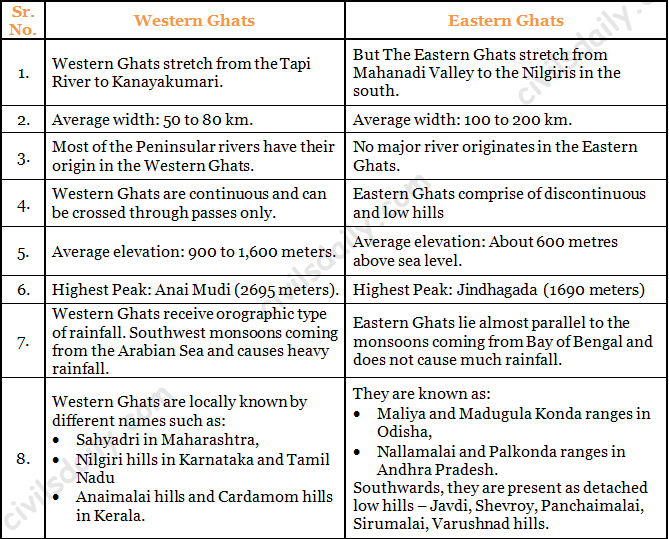
    d. None of the above


    Q.4) If a wetland of international importance is brought under the ‘Montreux Record’, what does it imply?

    a. Changes in ecological character have occurred, are occurring or are likely to occur in the wetland as a result of human interference.

    b. The country in which the wetland is located should enact a law to prohibit any human activity within five kilometers from the edge of the wetland

    c. The survival of the wetland depends on the cultural practices and traditions of certain communities living in its vicinity and therefore the cultural diversity therein should not be destroyed

    d. It is given the status of ‘World Heritage Site’


    Q.5) Which among the following is NOT part of ‘The New Delhi Declaration on Asian Rhinos 2019’?

    a. India

    b. Bhutan

    c. Myanmar

    d. Malaysia

  • [Prelims Spotlight] Important Historical Sculpture/Tribes in India, Their festivals, and Culture.


    Prelims Spotlight is a part of “Nikaalo Prelims 2020” module. This open crash course for Prelims 2020 has a private telegram group where PDFs and DDS (Daily Doubt Sessions) are being held. Please click here to register.


    19th March 2020


           Famous Sculpture/                             Painting Era/ Dynasty      Monument
    Bodhisattva Padmapani Gupta Period Ajanata
    Mahakapi Jataka Sunga Bharhut stupa
    Torso of Vishnu Gupta Period Mathura
    Stupa worship Mauryan/Sunga period Bharhut stupa
    Yakshini Mauryan/Sunga period Bharhut stupa
    Queen Maya’s dream Mauryan/Sunga period Bharhut stupa
    Painting of Yashodahara,Rahul & buddha Gupta Period Ajanata
    Standing Buddha Gupta Period Sarnath
    Seated Buddha Kushanas Mathura
    Standing Buddha Kushanas Gandhara
    Mara Vijaya Multiple period Ajanta
    Maheshmurthi Rashtrakuta Period Elephanta caves
    Shiva chasing boar Vijaynagara Period Lepakshi temple
    Shiva killing Tripurasura Thanjavoor
    Dakshinamurthy Vijaynagara Period Lepakshi temple
    Ladies attending Parvathy Vijaynagara Period Lepakshi temple
    Krishna playing the flute Pundareekapuram temple
    Sheshashayana Vishnu Gupta Period Dashavtar temple
    Vishnu in Nara-Narayan form Gupta Period Dashavtar temple
    Arjun Penance Pallavas Mahabalipuram
    Statue of Suparshvanatha Pallavas
    Statue of Gommateshwara, Ganga Dynasty Shravanbelagola, Karnataka
    Yakshi Mauryan Period Didarganj
    Durga with eight arms shown in the act of defeating Mahishasura, Pallavas Mahishasura Mardini Cave, Mahabalipuram
    Ravana Shaking Mount Kailasha Rashtrakuta Ellora
    Nandi bull Cholas Brihadeshwara temple
    Kalyana Sundara Murthy Rashtrakuta Ellora
    Nayika Ganga Dynasty Lingraj temple
    Nataraja Cholas Brideshwar temple
    Manjira player Ganga Dynasty Surya Mandir,Odhisa
    Mohini Hoysalas Chennakeshava temple
    Pillars with horse rider Naykas Meenakshi temple
    Worship of Bodhi tree Mauryan Period Bharhut
    Animals worshipping Bodhi tree Sungas Sanchi
    Yakshini Sungas Sanchi
    Taming of Nalagiri elephant Mauryan Period Amravati
    Head of Buddha Kushanas Gandhara
    Seated Buddha Kushanas Mathura
    Dwarfish Yaksha Pithalkoda caves
    Five Ratha Pallavas Mahabalipuram
    Vrikshika Sunga Sanchi Stupa
    Buddha’s Great departure Kushanas Gandhara
    Indra flying amid clouds together with celestial nymphs Gupta Period Ajanta


    The following table contains the tribes in India, significant aspects of their life, and festivals they celebrate.

    Name of the tribe States/ Region Significant aspects related to the tribe Festivals
    Munda Chota Nagpur Plateu 1.Christianity is their main religion.
    2..They speak Mundari which is austro-asiatic Language.
    Main festivals of Munda tribe are Mage Parab , Ind-Parab Jom-Nagoa or Jom Nawa ,Batauli ,Kolom Sing ,Phagu Festival ,Sarhul or Ba Parab ,Karam and Sohrai Festival
    Santhals West Bengal, Bihar, Orissa, Jharkhand and Assam. 1.Santhals are the third largest tribe in India.
    2.Santhals speak Santhali, which belongs to the Austro- Asiatic language family. Santhals have their script called Olchiki, which was developed by Dr Raghunath Murmu in 1925.
    3.Santhals have no temples of their own. They even do not worship any idols. Santhals follow the Sarna religion.
    Santhals mainly celebrate the Karam festival which falls in the month of September and October
    Angami Nagaland 1.Men wear shawls called white Mhoushu and the black Lohe. The women wear Mechala – the wrap around skirt and shawls of unique designs and patterns
    2.Christianity is the major religion followed among the Angami tribal people
    3.Angamis are quite popular for their woodcraft and artwork.
    Sekrenyi is the main festival celebrated among the Angamis in Nagaland.
    Bhils The central Bhils are found in the mountain regions in the Indian states of Madhya Pradesh, Maharashtra, Gujrat and Rajasthan. Bhils are also found in the north eastern parts of Tripura. 1.Religion practice among the Bhils differ from place to place. Most of them worship local deities like Khandoba, Kanhoba, Bahiroba, and Sitalmata. Some of the worship Tiger God called ‘vaghdev’. They have no temples of their own.
    2.Ghoomar is the most famous dance among the Bhils.
    3.Than Gair is the religious dance drama performed by the men in the month of Sharavana (July and August)
    The Baneshwar fair is the main festival celebrated among the Bhils. This fair is held during the period of Shivatri (in the month of January or February) and is dedicated to Baneshwar Mahadev also known as Lord Shiva. On this occasion Bhils gather all together set up camps on the banks of the Som and Mahi river.
    Chenchus Chenchu inhabit in the Nallamalai hills, which have been the part of the Nagarjuna Sagar Tiger Sanctuary for centuries in Andhra Pradesh India. 1.Chenchus talk in Chenchu language with the Telgu accent. Their language is also known as Chenchucoolam, Chenchwar, Chenswar or Choncharu.
    2.Chenchus worship number of deities. They mainly believe in Bhagaban taru who lives in the sky and look after the Chenchus in all their doings. Another deity they worship is Garelamai Sama, who is the Goddess of forest.
    Khasis Khasi tribe is mainly found in the sate of Assam and the Khasi Jaintia hills in Meghalaya 1.Khasis speak Khasi, which is an Austro- Asiatic language. It is the part of the Mon-Khmer group of languages.
    2.Khasis have a matriachal society.
    3.Most of the Khasis follow Christianity as the religion. The Khasi believe in the supreme creator God U Blei Nong-thaw.
    Nongkrem is the major festival celebrated among the Khasis.
    Bhuthias Bhutia tribes are of the Tibetan origin. They migrated to Sikkim around 16th century. In the northern part of the Sikkim where they are the major inhabitants, they are known as the Lachenpas and Lachungpas. Majority of the Bhutias are concentrated in the dry valley of the North Sikkim. 1.Bhutia tribes usually speak Sikkimese.
    2.The legal system among the Bhutias is termed as the Dzumsa, which means the rendezvous point of the common masses.
    3. Bhutia male wear Bakhu which is a loose traditional dress with the full sleeves. While the women dress consists of Silken Honju, which is the full sleeves blouse
    Losar and Losoong are the main festivals celebrated among the Bhutia tribes.
    Gonds The Gonds are the tribal community mostly found in the Gond forests of central India. They are widely spread in the Chhindwara District of Madhya Pradesh 1.Gonds tribe speak Gondi language which is related to the Telgu and the other Dravidian languages.
    2.Gonds have been largely influenced by the Hindus and for the long time have been practicing the Hindus culture and traditions. Gonds are the worshipers of Janani or the mother of creator.
    3.Gusadi dance is the most famous dance perfomed by the Gonds.
    Gonds fair and festivals are influenced from the Hindu traditions. Keslapur Jathra is the important festival of the Gonds.
    Gaddis Himachal Pradesh. 1.The main occupation of Gaddi tribes is shepherding and they make their livelihood by rearing and selling sheeps, goats, mules and horses
    2. They speak Gaddi langauge
    The Namagen dance is performed in the month of September to celebrate the autum. They were costumes which are largely woolen and studded with ornaments of silver. They are worn by women.
    Birhor Chattisgarh 1.They follow Hinduism and have their indigenous traditional beliefs. ‘Sing Bonga’, is regarded by the people as the supreme god.
    2.Birhor tribe is one of the primitive tribes. They belong to the Proto-Australoid stock; linguistically, they originate from the Austro-Asiatic group.
    Garo Meghalaya 1.In Garo tribes, women are the owners of property thus making it a matrilineal society.
    2.most of the Garos adopted Christianity. These tribes speak Garo language, which is also further divided into different sub-languages or dialects.
    Wangala is one of the significant festivals of these tribes This festival is celebrated after the harvest of crops as thanks giving ceremony to their deity Salijong
    Zeliang Nagaland 1.The Zeliang practice wet cultivation or Panikheti and terraced cultivation. They practice Jhum cultivation though they prefer Panikheti.
    2.Many have accepted the religion of Christianity.
    The Hega festival is one of the most important and the largest festivals among the Zeliang community
    Rengma Nagaland 1.They belong to the Mongoloid racial stock. The Rengma is a patriarchal society therefore the line of descent is traced through the male side and property rights goes to the male line.

    2.The Rengma tribes are agriculturists. They grow paddy through Jhum cultivation and wet cultivation.

    3.Traditionally Rengma tribes are worshippers of supernatural beings. The Supreme god is known as Teronyu. Nyensug and Nyensugi are the next important god and goddesses who are worshipped for household wealth. Now most of the Rengma tribes are Christians

    Ngada is the most important festival of Rengma tribes. It is celebrated after harvesting the crop or at the end of November or in the beginning of December. Actually it is a “Thanks giving” festival of the Rengma tribes
    Ao Nagaland The Ao Nagas are rich in their folk literature.
    With the arrival of Christian missionaries in the 19th century the Ao were some of the earliest converts to Christianity among the other Naga tribes.
    1. The Aos observe Moatsü Mong after the sowing is done. The festival provides them a period of recreation and entertainment after the stressful work of clearing fields, burning jungles, sowing seeds, cleaning up the Tsubu (wells) and repairs and construction of houses by elders of the Putu Menden, stretching over a week.
    2.Aos have another festival called Tsüngrem Mong. It is celebrated in the eve of the harvest.
    Lushai Manipur/Mizoram 1.Lushai tribes have developed expertise in swimming and hunting. That they are good archers are apparent from the fact that they can nicely handle ‘Sairawkher’.
    2.The way they dress shows that these Lushai tribes have got aesthetic sense. Lukhum is a special hat worn by the Lushai tribes. It is sharp in shape, mainly prepared from ‘bamboo splits’. Special open-hexagonal weave are used for weaving these hats.
    3.For proper administration, the whole of the Lushai society are segregated into clans and castes, nicely run by a village head. Different is the way in which they practice the ‘Sakhua sacrifice’. These Lushai tribes are pious.
    There Bamboo dance(known as Cheraw dance) is very famous.
    Hmar Manipur 1.The society is patrilineal and patriarchal in nature.
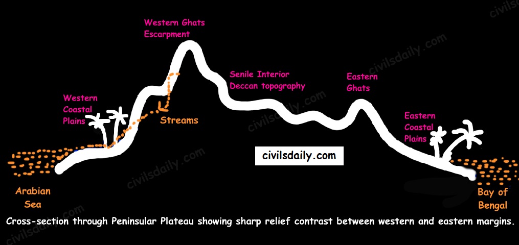
    2. Hmars worship supernatural beings. Pathien is the supreme god.
    3.The Hmars depend on forest products. Their economy can be classified dually -traditional and subsidiary occupations.
    Chawn-lam, Dar-lam, Pheipheet-lam, Hrang-lam, Tinna-Hla-lam are the common dances of the Hmar community. All dances are based on the rhythmic tunes of musical instruments.
    Kuki Manipur Kuki Tribe of Manipur are mainly followers of Christianity and Judaism.
    Mizo Mizoram 1.The Mizos are of the Mongoloid racial stock with well built features.
    2.They follow Christianity
    3.The Mizos are mainly an agricultural people. Jhum cultivation is the traditional form of agriculture that is practiced
    The Mizo celebrate many festivals among which Chapchar kut and Pavlkut are most important festivals. Chapchar kut is celebrated in the month of March. It is the spring festival celebrated. Pawl kut is a harvest festival celebrated in the months of December and January.
    Chakesang Nagaland Held in between March and April, the Tsukhenyi festival is one of the least known tribal festivals in India that is celebrated with great enthusiasm by the Chakesang Nagass
    Limboos Sikkim 1.Many Limbu follow a combination of Buddhism and their traditional beliefs.
    2.There traditional group dance is called dhannach and is performed during marriage,death or any festivities
    3.The traditional dress of Limboos are mekhli and Taga
    Lepchas Sikkim 1.The Lepchas are the aboriginal inhabitants of Sikkim and they are mostly settled in North Sikkim. They are mostly Buddhist but many of them have now adopted Christianity
    2. The traditional cloths of the Lepchas are woven in exquisite colour combinations. Men’s dress is called Thokro-Dum and the female’s dress is called Dumdyam or Dumvum.
    3. The Lepcha trace their descent patrilineally. The marriage is negotiated between the families of the bride and the groom.
    Apatani Aruanchal Pradesh 1.UNESCO has proposed the Apatani valley for inclusion as a World Heritage Site for its “extremely high productivity” and “unique” way of preserving the ecology
    2. Women of the Apatani Tribe, in India’s Apatani plateau, are famous for the bizarre nose plugs they’ve been wearing since times long passed.
    They have two major festival- Dree and Myoko.
    Nyishis Aruanchal Pradesh 1.The Nyishi language belongs to the Sino-Tibetan family, however, the origin is disputed.
    2.Polygyny is prevalent among the Nyish.
    3. The Nyishis, who traditionally wear cane helmets surmounted by the crest of a hornbill beak (known as pudum, padam), have considerably affected the population of this bird.
    Several organizations, such as the Arunachal Wildlife and Nature Foundation and the Wildlife Trust of India, have been trying to stop the Nyishi hunting these birds in order to protect them from extinction. Nature reserves, such as the Pakke Sanctuary, are being set up to protect the birds, while artificial materials, such as fiberglass, have been introduced as an alternative to the hornbill beak in Nyishi dress.
    Nyokum is the festival celebrated by the Nyishi people, a religion which commemorates their ancestors.
    Adis Aruanchal Pradesh Adi dances vary from the slow, rustic and beautifully enchanting style Ponung (performed in Solung festival) to the exhilarating, exuberant thumps of Delong performed by Men in Etor festival. These dances have led to certain forms of dancing which jointly narrate a story, the Tapu (War Dance). In the Tapu War Dance, the dancers vigorously re-enact the actions of war, its gory details and the triumphant cries of the warriors. Yakjong is performed in Aran festival. The Adi celebrate a number of festivals, in particular their prime festivals are Aran, Solung, Etor.Solung, is observed in the first week of September for five days or more. It is a harvest festival performed after the sowing of seeds and transplantation, to seek for future bumper crops. Ponung songs and dances are performed by women folk during the festival
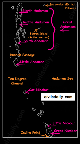
    Sema/Sumi Nagas Nagaland 1.The ‘Sumi Naga’ is one of the major Naga peoples in Nagaland, India. The Sumis mainly inhabit the Zunheboto district, although many have spread and is now living in a few more districts within Nagaland.
    2.Sumi Naga tribe practiced kiti-do and were a headhunter as every other Naga tribals .
    Tuluni (July 8) is a festival of great significance for the Sumi. This festival is marked with feasts as the occasion occurs in the bountiful season of the year. Drinking rice beer indispensably forms as part of the feasts. Rice beer is served in a goblet made of bamboo or made from the leaf of plantain. This drink is called Tuluni which gives the festival its name.
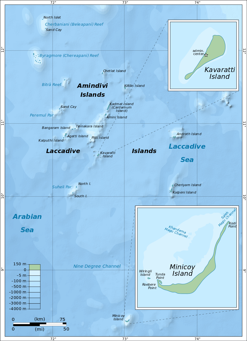
    Konyak tribe Nagaland The Konyak are a Naga people, and are recognised among other Naga by their tattoos, which they have all over their face and hands; facial tattoos were earned for taking an enemy’s head. They are called the land of Angh’s. They have the largest population among the Nagas. Aoleang is the biggest festival for the Konyak. They wear their traditional attire and sing folk song to celebrate the Aoleang festival.
    Reang Tripura 1.The Reangs are basically a semi-nomadic tribe who practice jhum (slash and burn) or shifting method of cultivation on the hill sides.
    2. The Reang basically belonged to the Mongoloid group and speaks the Tibeto-Burmese language ‘Kau Bru
    The Hodaigri dance amongst the Reang (Bru) was usually performed on the occasion of Maikhlungmo rituals i.e. worship of Goddess of food grains and cotton especially during the month of September-October
    Mishing Assam 1.The Mishing tribe is the second largest tribe among the other tribes of North- East India.
    2.Traditionally Mishing people live near the bank of river and they build their “Chang Ghar” with the help of timber bamboo, thatch, etc for comfort living.
    Mishing people are easy going, very simple living and are fond of festivals. The main festival is “Ali-Aye-Ligang” which is the most colourful spring festival held every year on first Wednesday of the month “Gimur polo”(Feb-March).
    Karbi Assam 1.The Karbis believes in animism which consists of such a belief in the role of spiritual beings in human life.
    2. Various types of dances are performed by the youths during the performances of Chomangkan, the death ceremony and other socio-religious festivals. The Karbis have very limited number of musical instruments. A big drum called Cheng is their main musical instrument.
    A number of festivals are observed by the people belonging to Karbi tribal group. Like for instance, they celebrate ‘Chojun Puja’ or ‘Swarak Puja’, ‘Rongker’, ‘Chokk-eroi’, ‘Hacha-Kekan’, ‘Chomangkan’.
    Mikir Assam
    Kols Madhya Pradesh Most of these tribes are landless labourer. They prefer to live in groups near villages called Kolhan
    Bonda Odhisa The Bonda are an ancient tribe of people who live in the isolated hill regions of the Malkangiri district of southwestern Odisha, India,
    Oarons Odhisa,Bihar and Jharkhand 1.Oraon also called Kurukh, aboriginal people of the Chota Nagpur region in the state of Jharkhand, India. They call themselves Kurukh and speak a Dravidian language akin to Gondi and other tribal languages of central India.
    2.Speakers of Oraon number about 1,900,000, but in urban areas, and particularly among Christians, many Oraon speak Hindi as their mother tongue.
    3.It was long thought that the Oraons and the other tribals were animists, people who attribute a living soul to plants, inanimate objects and natural phenomena. This view has been discarded although amateur anthropologists still sort it out in articles, in popular magazines. The Oraons are not nature worshipers.
    Murias Chattisgarh 1.The Muria are an adivasi (scheduled tribe) of the Bastar district of Chhattisgarh, India. They are part of the Gondi people.
    2.They have mixed-sex dormitories where adolescents are sent to practice premarital sex, sometimes with a single partner and sometimes serially.
    3.The Muria are traditionally animists, with village and clan deities
    Korba Chattisgarh Famous for there Karma dance
    Sahariya Rajasthan 1.Sahariya Tribe is the only primitive tribe of the Rajasthan state
    2.They follow Hindu religious practices and speak a dialect influenced by Hadoti.
    Irulas Tamil Nadu 1. They inhabit the area of the Nilgiri mountains, in the states of Tamil Nadu and Kerala, India
    2.Early 20th century anthropological literature classified the Irular under the Negrito ethnic group.
    3.Unlike the Negrito tribes in the Andaman Islands who have retained their language, Irular speak the Irula language, a Dravidian language that is closely related to Tamil, Yerukala, Sholaga and other Tamil languages
    Badagas Tamil Nadu 1.The Badagas live in the Nilgiri Hills of Tamil Nadu, India. They speak the unwritten Badaga language and are the one of the social groups in Nilgiris
    2.Thundu (a white piece of cloth) forms an integral part of the attire of Badaga women and as a cultural item, is presented to visiting dignitaries as a gesture of good will.
    Their important festival is Hethai Habba.
    Uralis Kerela 1.The Urali tribes like most of the tribes in south India, worship nature as Gods and inventor of the world. They consider the Sun as ‘the creator of all souls’ and moon as the mother of all creation.
    2.The Uralis generally do not engage in inter-tribal marriage, instead they prefer to marry within their own tribe. It is custom amongst them to wear a sacred thread on special occasions like weddings and funerals.
    Jarawas Andaman & Nicobar Island 1.The Jarawa are still at the primitive stage of life on earth. They entirely depend upon forest and sea for food. Wild boar and monitor lizard are consumed. Various kinds of fruit , honey and tubers are parts of their diet too.
    2.The jarawas of both sexes go complete naked. However some ornaments made with shells and palm leaves are worn by them but these are not in the sense to cover their nudity.
    This tribe has lived in the southeast part of Andaman but after the British regime they shifted to the western region of the island. They have forever been hunter gatherers in the true sense however things have changed since the 1990’s specially after the building of the old trunk road.
    Sentinelese Andaman & Nicobar Island 1.The Sentinelese people are said to be so hostile that their home has been named the ‘hardest place to visit’ in the world.The Sentinelese and other indigenous Andamanese peoples are frequently described as negritos,
    2.They inhabit the North Sentinel island, and are the only remaining tribe in the Andamans to still maintain their isolation from the rest of the world. Nobody knows exactly how they look, the population or how they live. Since 1967, the indian governments with the help of anthropologists have tried to make contact with the tribe. They tried giving gifts of food, coconuts, etc but they were always met with hostility. The tribe showers arrows and stones at whoever comes near the island.
    .
    Onge Andaman & Nicobar Island Onges are one of the most primitive tribes in India. They belong to the Negrito racial stock and they have been mainly seen near the Dugong creek in Little Andaman. They are dependent on the food provided by nature and are a semi-nomadic tribe.
    The onge population fell post british colonization from 672 in 1986 to 92 in 1901 but has remained stable since.
    Shompen Andaman & Nicobar Island The Shompens, who live in the Great Nicobar island, are a semi-nomadic people. They wander in their forest and coastal habitat in search of fruits and games. There are two territorial groups among the Shompens; The habitation of Shompens is the Great Nicobar which is the largest among the Nicobar group of Islands. Like the Nicobarese, they belong to the Mongoloid race.
    Pangwal Himachal Pradesh. 1.These rugged people, who are Hindus, have their unique customs, traditions, and institutions. The native Pangwals and Bhotis are robust, hardworking, handsome people who keep the valley’s unique culture alive in folk songs, music and tribal dances. Music, dance and the locally brewed liquor ‘patar’, play a significant role in the life of the Pangwals. One of the major festivals celebrated towards the end of February is ‘Jukaru’
    Sherdukpen Aruanchal Pradesh 1.The Sherdukpen language is part of the Kanauri branch of the Tibeto-Burman family.
    2.Bardo Chham is a folk dance of Sherdukpens, a small community of West Kameng District of Arunachal Pradesh, Bardo Chham is based on the stories of good and evil. According to the local beliefs, there are both good and evil in mankind. The Sherdukpens mask themselves representing the different animals and dance to show an act of fighting the evil forces.
    Wattal tribe Jammu & Kashmir Dumhal dance is performed by Wattal tribe on special occassions
    Bhutias Sikkim 1.The Bhutia are a community of people of Tibetan ancestry, who speak Lhopo or Sikkimese, a Tibetan dialect fairly mutually intelligible to standard Tibetan
    2. Singhi Chham or Kanchendzonga Dance is a dance form in Sikkim whereby the dancers perform in a lion costume that represents the snow lion. It is a dance of the Bhutia people
    Todas Tamil Nadu Tribals of Nilgiri hills