This Spotlight is a part of our Mission Nikaalo Prelims-2023.
You can check the broad timetable of Nikaalo Prelims here
Session Details
YouTube LIVE with Parth sir – 7 PM – Prelims Spotlight Session
Evening 04 PM – Daily Mini Tests
Join our Official telegram channel for Study material and Daily Sessions Here
17th Apr 2023
Trans-Pacific Partnership
The Trans-Pacific Partnership (TPP), or the Comprehensive and Progressive Agreement for Trans-Pacific Partnership (CPTPP), is a trade agreement between Australia, Brunei Darussalam, Canada, Chile, Japan, Malaysia, Mexico, New Zealand, Peru, Singapore, the United States (until 23 January 2017) and Vietnam
The TPP began as an expansion of the Trans-Pacific Strategic Economic Partnership Agreement (TPSEP or P4) signed by Brunei Darussalam, Chile, New Zealand, and Singapore in 2005
The TPP contains measures to lower both non-tariff and tariff barriers to trade and establish an investor-state dispute settlement (ISDS) mechanism
The agreement will enter into force after ratification by all signatories if this occurs within two years
APEC members may accede to the TPP, as may any other jurisdiction to which existing TPP members agree. After an application for membership is received, a commission of parties to the treaty negotiates conditions for accession.
BRICS
BRICS is the acronym coined for an association of five major emerging national economies: Brazil, Russia, India, China and South Africa.
Originally the first four were grouped as “BRIC” (or “the BRICs”), before the induction of South Africa in 2010.
The BRICS members are known for their significant influence on regional affairs; all are members of G20.
Since 2009, the BRICS nations have met annually at formal summits. China hosted the 9th BRICS summit in Xiamen on September 2017, while Brazil hosted the most recent 11th BRICS summit on 13-14 November 2019.
New Development Bank and the Fortaleza Declaration
During the sixth BRICS Summit in Fortaleza (2014), the leaders signed the Agreement establishing the New Development Bank (NDB).
In the Fortaleza Declaration, the leaders stressed that the NDB will strengthen cooperation among BRICS and will supplement the efforts of multilateral and regional financial institutions for global development, thus contributing to collective commitments for achieving the goal of strong, sustainable and balanced growth.
The bank was established in July 2015 by the BRICS countries (Brazil, Russia, India, China and South Africa).
The aim of the bank is to mobilize funding for infrastructure and sustainable development.
Its ownership structure is unique, as the BRICS countries each have an equal share and no country has any veto power.
In this sense, the bank is a physical expression of the desire of emerging markets to play a bigger role in global governance.
NDB was created to help fill the funding gap in the BRICS economies and was intended to grow its global scope over time.
The bank, with its subscribed capital base of US$50bn, is now poised to become a meaningful additional source of long-term finance for infrastructure in its member countries.
The Regional Comprehensive Economic Partnership (RCEP) is a trade deal that was being negotiated between 16 countries.
They include the 10 ASEAN members and the six countries with which the bloc has free trade agreements (FTAs) — India, Australia, China, Korea, Japan, and New Zealand.
The purpose of the deal is to create an “integrated market” spanning all 16 countries.
This means that it would be easier for the products and services of each of these countries to be available across the entire region.
RCEP – India
It comprises half of the world population and accounts for nearly 40% of the global commerce and 35% of the GDP. RCEP would have become the world’s largest FTA after finalisation, with India being the third-biggest economy in it.
Without India, the RCEP does not look as attractive as it had seemed during negotiations.
Divided ASEAN – ASEAN has been keen on a diversified portfolio so that member states can deal with major powers and maintain their strategic autonomy. ASEAN member states have tried to keep the U.S. engaged in the region.
Act East policy has been well received. With China’s rise in the region, ASEAN member states have been keen on Indian involvement in the region.
Indo-Pacific – India’s entire Indo-Pacific strategy might be open to question if steps are not taken to restore India’s profile in the region.
Rejected China’s dominance – India signalled that, despite the costs, China’s rise has to be tackled both politically and economically.
Shanghai Cooperation Organisation (SCO)
After the collapse of the Soviet Union in 1991, the then security and economic architecture in the Eurasian region dissolved and new structures had to come up.
The original Shanghai Five were China, Kazakhstan, Kyrgyzstan, Russia and Tajikistan.
The SCO was formed in 2001, with Uzbekistan included. It expanded in 2017 to include India and Pakistan.
Since its formation, the SCO has focused on regional non-traditional security, with counter-terrorism as a priority:
The fight against the “three evils” of terrorism, separatism and extremism has become its mantra.
Today, areas of cooperation include themes such as economics and culture.
India’s entry to the SCO
India and Pakistan both were observer countries.
While Central Asian countries and China were not in favour of expansion initially, the main supporter — of India’s entry in particular — was Russia.
A widely held view is that Russia’s growing unease about an increasingly powerful China prompted it to push for its expansion.
From 2009 onwards, Russia officially supported India’s ambition to join the SCO. China then asked for its all-weather friend Pakistan’s entry.
The Bay of Bengal Initiative for Multi-Sectoral Technical and Economic Cooperation (BIMSTEC)
The Bay of Bengal Initiative for Multi-Sectoral Technical and Economic Cooperation (BIMSTEC) is a regional organization comprising seven Member States lying in the littoral and adjacent areas of the Bay of Bengal constituting a contiguous regional unity. This sub-regional organization came into being on 6 June 1997 through the Bangkok Declaration.
The regional group constitutes a bridge between South and South-East Asia and represents a reinforcement of relations among these countries.
BIMSTEC has also established a platform for intra-regional cooperation between SAARC and ASEAN members. The BIMSTEC region is home to around 1.5 billion people which constitute around 22% of the global population with a combined gross domestic product (GDP) of 2.7 trillion economies. In the last five years, BIMSTEC Member States have been able to sustain an average 6.5% economic growth trajectory despite a global financial meltdown.
SAARC & SAARC Countries
The South Asian Association for Regional Cooperation (SAARC) is a regional intergovernmental organization and geopolitical union in South Asia. Its member states include Afghanistan, Bangladesh, Bhutan, India, Nepal, the Maldives, Pakistan and Sri Lanka. SAARC was founded in Dhaka in 1985.
Its secretariat is based in Kathmandu.
The organization promotes the development of economic and regional integration.
It launched the South Asian Free Trade Area in 2006.
SAARC maintains permanent diplomatic relations at the United Nation as an observer and has developed links with multilateral entities.
Observers Of SAARC: – States with observer status include Australia, China, the European Union, Iran, Japan, Mauritius Myanmar, South Korea and the United States.
Association of Southeast Asian Nations (ASEAN)
The Association of Southeast Asian Nations is a regional intergovernmental organization comprising ten Southeast Asian countries
It promotes Pan-Asianism and intergovernmental cooperation and facilitates economic, political, security, military, educational and socio-cultural integration amongst its members and other Asian countries
It members are Indonesia, Malaysia, the Philippines, Singapore, Thailand, Brunei, Cambodia, Laos, Myanmar, and Vietnam
ASEAN shares land and maritime borders with India, China
ASEAN is an official United Nations Observer.
The Nuclear Suppliers Group (NSG)
The Nuclear Suppliers Group (NSG) is a group of nuclear supplier countries that seeks to contribute to the non-proliferation of nuclear weapons through the implementation of two sets of Guidelines for nuclear exports and nuclear-related exports.
One of the critical elements for inclusion into the NSG is that the member countries need to signatories of the NPT, a proposal which India has categorically disagreed.
However considering India’s history of nuclear non-proliferation, the US and subsequently the NSG have shown some recognition and granted India with the waiver of dealing with other countries for nuclear technology.
Organisation for the Prohibition of Chemical Weapons (OPCW)
OPCW is an intergovernmental organization and the implementing body for the Chemical Weapons Convention, which entered into force on 29 April 1997
The OPCW, with its 193 member states, has its seat in The Hague, Netherlands, and oversees the global endeavour for the permanent and verifiable elimination of chemical weapons
The organization promotes and verifies the adherence to the Chemical Weapons Convention, which prohibits the use of chemical weapons and requires their destruction
Verification consists both of evaluation of declarations by member states and onsite inspections
The OPCW has the power to say whether chemical weapons were used in an attack it has investigated
The organization was awarded the 2013 Nobel Peace Prize “for its extensive efforts to eliminate chemical weapons”
The Australian Group
The Australia Group is a multilateral export control regime (MECR) and an informal group of countries (now joined by the European Commission) established in 1985 (after the use of chemical weapons by Iraq in 1984) to help member countries to identify those exports which need to be controlled so as not to contribute to the spread of chemical and biological weapons
The group, initially consisting of 15 members, held its first meeting in Brussels, Belgium, in September 1989. With the incorporation of India on January 19, 2018, it now has 43 members, including Australia, the European Commission, all 28 member states of the European Union, Ukraine, and Argentina
The name comes from Australia’s initiative to create the group. Australia manages the secretariat
The initial members of the group had different assessments of which chemical precursors should be subject to export control
Later adherents initially had no such controls
Today, members of the group maintain export controls on a uniform list of 54 compounds, including several that are not prohibited for export under the Chemical Weapons Convention but can be used in the manufacture of chemical weapons
In 2002, the group took two important steps to strengthen export control
The first was the “no-undercut” requirement, which stated that any member of the group considering making an export to another state that had already been denied an export by any other member of the group must first consult with that member state before approving the export
The second was the “catch-all” provision, which requires member states to halt all exports that could be used by importers in chemical or biological weapons programs, regardless of whether the export is on the group’s control lists.
Delegations representing the members meet every year in Paris, France
WTO
US, UK and a few other countries set up, an interim organisation about trade named GATT (General Agreement on Tariff and Trade) in 1947
GATT was biased in favourof the developed countries and was called informally as the Rich men’s club.
So, the developing countries insisted on setting up the International Trade Organisation (ITO)
That’s the reason, the United Nations Conference on Trade and Development (UNCTAD) was set up in 1964 as an alternative, on the recommendation of the UN committee
Next development comes in Uruguay Round of GATT, it sought to expand the scope of the organisation by including, services, investment and intellectual property rights (IPR)
Agreements were ratified by the legislatures of 85 member-countries by year-end 1994.
On such rectification, the WTO started functioning from Jan 1, 1995, < Marrakesh Agreement>
Functions of WTO
The WTO deals with regulation of trade in goods, services and intellectual property between participating countries.
It provides a framework for negotiating trade agreements and a dispute resolution process aimed at enforcing participants’ adherence to WTO agreements, which are signed by representatives of member governments and ratified by their parliaments.
G20
Formed in 1999, the G20 is an international forum of the governments and central bank governors from 20 major economies.
Collectively, the G20 economies account for around 85 percent of the Gross World Product (GWP), 80 percent of world trade.
To tackle the problems or the address issues that plague the world, the heads of governments of the G20 nations periodically participate in summits.
In addition to it, the group also hosts separate meetings of the finance ministers and foreign ministers.
The G20 has no permanent staff of its own and its chairmanship rotates annually between nations divided into regional groupings.
Aims and objectives
The Group was formed with the aim of studying, reviewing, and promoting high-level discussion of policy issues pertaining to the promotion of international financial stability.
The forum aims to pre-empt the balance of payments problems and turmoil on financial markets by improved coordination of monetary, fiscal, and financial policies.
It seeks to address issues that go beyond the responsibilities of any one organisation.
Member Countries
The members of the G20 consist of 19 individual countries plus the European Union (EU).
The 19 member countries of the forum are Argentina, Australia, Brazil, Canada, China, France, Germany, India, Indonesia, Italy, Japan, Mexico, Russia, Saudi Arabia, South Africa, South Korea, Turkey, United Kingdom and the United States.
The European Union is represented by the European Commission and by the European Central Bank.
Who are the G20 Sherpas?
A Sherpa is the personal representative of a head of state or government who prepares an international summit, particularly the annual G7 and G20 summits.
Between the summits, there are multiple Sherpa conferences where possible agreements are laid out.
This reduces the amount of time and resources required at the negotiations of the heads of state at the final summit.
The Sherpa is generally quite influential, although they do not have the authority to make a final decision about any given agreement.
The name is derived from the Sherpa people, a Nepalese ethnic group, who serve as guides and porters in the Himalayas, a reference to the fact that the Sherpa clears the way for a head of state at a major summit.
G7
The G7 or the Group of Seven is a group of the seven most advanced economies as per the International Monetary Fund (IMF).
The seven countries are Canada, USA, UK, France, Germany, Japan and Italy. The EU is also represented in the G7.
These countries, with the seven largest IMF-described advanced economies in the world, represent 58% of the global net wealth ($317 trillion).
The G7 countries also represent more than 46% of the global gross domestic product (GDP) based on nominal values, and more than 32% of the global GDP based on purchasing power parity.
The requirements to be a member of the G7 are a high net national wealth and a high HDI (Human Development Index).
Five private firms have been allowed by the Central Government to engage in cluster farming of specific horticulture crops on a pilot basis.
The goal of this initiative is to enhance the competitiveness of Indian produce on a global scale and increase the earnings of farmers.
Overview of the Horticulture Sector in India
India is the world’s second-largest producer of horticulture crops. It is a leading producer of fruits such as Mango, Banana, Pomegranate, Sapota, Acid Lime and Amla. UP was the top state in horticulture production in 2021-22, followed by MP and West Bengal. West Bengal, UP and MP were the top states in vegetable production. Maharashtra followed by AP and UP were the top states in fruit production. The area under horticulture crops increased to 27.74 million hectares in 2021-22, producing around 341.63 million tonnes.
What is Cluster Farming?
Cluster farming is a strategy aimed at improving the global competitiveness of Indian produce and boosting farmers’ income.
It involves the regional concentration of targeted horticulture crops to allow for specialization in production, post-harvest management, marketing, and exports.
Features of cluster farming include
Collaboration: It is a collaborative effort where farmers work together to share resources, knowledge, and expertise to achieve common goals.
Resource sharing: It involves sharing resources such as land, water, labor, and equipment to achieve economies of scale and reduce the cost of production.
Specialization: It allows farmers to specialize in particular crops or livestock, which enables them to become experts in their chosen areas and increase their productivity.
Marketing: It enables farmers to market their products more effectively by pooling their resources and creating a unified marketing strategy.
Infrastructure development: It involves the development of shared infrastructure such as irrigation systems, warehouses, and processing facilities, which improves efficiency and reduces costs.
Environmental sustainability: It promotes environmental sustainability by encouraging farmers to adopt eco-friendly farming practices, such as conservation agriculture and integrated pest management.
Why need Cluster Farming in India?
There are several reasons why cluster farming is needed in India:
Income push for small farmers: India has a high percentage of small and marginal farmers who own less than 2 hectares of land. Cluster farming can help small farmers pool their resources and achieve better access to inputs, services, and markets.
Youth retention: Many young people are leaving rural areas in search of better economic opportunities in urban areas. Cluster farming can help create job opportunities in rural areas and improve the livelihoods of rural communities.
Supply chains utilization: India’s agriculture supply chain is fragmented, resulting in low prices for farmers and high prices for consumers. Cluster farming helps farmers create a unified supply chain and market their products effectively, reducing intermediaries and improving prices.
Filling infrastructure gap: Many parts of rural India lack basic infrastructure such as roads, irrigation systems, and storage facilities. Cluster farming can help farmers share the cost of building and maintaining such infrastructure, which can improve efficiency and reduce costs.
Mitigate climate change: Climate change is increasingly affecting India’s agriculture sector, with frequent droughts, floods, and extreme weather events. Cluster farming can help farmers adopt climate-resilient farming practices and reduce their vulnerability to climate change.
Key initiative: Horticulture Cluster Development Programme
The CDP is a recently launched central scheme with an outlay of Rs 2,200 crore.
It is a central sector programme aimed at growing and developing identified horticulture clusters to make them globally competitive.
Under the CDP, financial assistance of up to Rs 100 crore will be provided to projects based on their size.
Implementation strategy
The National Horticulture Board (NHB) is responsible for implementing it.
The list of 55 clusters, each with a focus on specific crops, includes states such as Arunachal Pradesh, Assam, West Bengal, Manipur, Mizoram, Jharkhand, and Uttarakhand.
During the pilot phase, it was implemented in 12 clusters across 11 states and union territories.
Objectives of the CDP
Export promotion: Improve exports of targeted crops by 20% and create cluster-specific brands to enhance competitiveness
Sectoral reform: Address all major issues related to the Indian horticulture sector including pre-production, production, post-harvest management, logistics, marketing and branding
Leverage geographical specialisation: Promote integrated and market-led development of horticulture clusters
Converge with other government initiatives: Such as the Agriculture Infrastructure Fund
Attract investment
Other initiatives
(1) Mission for Integrated Development of Horticulture (MIDH)
MIDH is a centrally sponsored scheme for the holistic growth of India’s horticulture sector, covering fruits, vegetables, and other areas.
The government of India contributes 60% of the total outlay for developmental programs in all states (except North Eastern and Himalayan states where it contributes 90%), with 40% contributed by state governments.
(2) Project CHAMAN
The project name stands for “Coordinated Horticulture Assessment and Management using Geo-informatics.”
It is focused on leveraging geo-informatics, which involves using spatial data, to provide assistance to farmers and improve the overall management of the horticulture sector.
It aims to provide farmers with accurate and up-to-date information on factors such as weather patterns, soil moisture levels, and disease outbreaks.
(3) National Horticulture Board (NHB)
NHB is a government organization that provides financial assistance and other support to promote the development of the horticulture sector.
The NHB provides support for various activities, including production, post-harvest management, marketing, and export.
Hurdles for horticulture development in India
Fragmented landholdings: Land fragmentation is a major issue in many horticulture clusters in India, which can make it difficult for farmers to achieve economies of scale and adopt modern farming practices.
Inadequate market linkages: Many farmers in horticulture clusters have limited access to markets, which can result in low prices for their produce. Improving market linkages is crucial for promoting the growth of the horticulture sector.
Pest and disease management: Pests and diseases can pose a major threat to horticulture crops, and managing these risks can be challenging for small-scale farmers who may lack access to information and resources.
Way forward
Land consolidation: The government could encourage land consolidation in horticulture clusters, which would enable farmers to achieve economies of scale and adopt modern farming practices.
Facilitate access to finance: The government could work with financial institutions to provide credit and other financial services to small-scale farmers in horticulture clusters. This would enable farmers to invest in their farms and adopt new technologies.
Establish market linkages: The government could work with private sector players to develop market linkages for farmers in horticulture clusters. This would help farmers get better prices for their produce and improve their livelihoods.
Pest and disease management: The government could provide training and support to farmers in horticulture clusters on pest and disease management. This would help farmers adopt eco-friendly pest and disease management practices and reduce crop losses.
This Spotlight is a part of our Mission Nikaalo Prelims-2023.
You can check the broad timetable of Nikaalo Prelims here
Session Details
YouTube LIVE with Parth sir – 7 PM – Prelims Spotlight Session
Evening 04 PM – Daily Mini Tests
Join our Official telegram channel for Study material and Daily Sessions Here
14th Apr 2023
Constitutional bodies
Appointment
Tenure
Removal
Process of removal
Eligibility for reappointment w/i govt
Attorney general (Advocate general)
President (governor)
Pleasure of President (governor)
President (governor)
No reason needs to be mentioned
Yes
Election Commission (SEC)
President (governor)
6 years/ 65
President
CEC and SEC by a special majority
Other ECs on the recommendation of CEC
Yes
Finance commission (SFC)
President (governor)
Specified by president
NA
NA
Yes
UPSC (SPSC)
President (governor)
6 years/ 65
President
After enquiry by supreme court
Members can become Chair, state members can become chair or member or chair of UPSC
CAG
President
6 years/ 65
President
Special majority
No
Statutory bodies
Appointment
Committee members
Other members
Tenure
Removal
NHRC (SHRC)
President (Governor)
6 (PM + LOP Lok Sabha)
Speaker, Deputy CP RS, LOP RS, home minister
3 years*/ 70
President after Supreme Court inquiry
CIC (SIC)
President (Governor)
3 ((PM + LOP Lok Sabha)
Cabinet Minister nominated by PM
As prescribed by the Central Govt*./ 65
President (governor for SIC) after supreme court inquiry
CVC
President (governor)
3 ((PM + LOP lok sabha)
Home minister
4 years/ 65
President after Supreme court inquiry
Lokpal
President
5 (PM + LOP lok sabha
Speaker, CJI, eminent jurist
5 years/ 70
Like a Supreme Court judge
Regulatory Bodies
Regulatory bodies in India
Sector
Functions
Telecom Regulatory Authority of India – TRAI
Telecommunication and Tariffs
To make regulations to ease competition and enhance the efficiency in the operation of telecommunication services
Competition Commission of India (CCI)
Company affairs
To protect the interest of consumers, prevent some practices having harmful effect on competition
Securities and Exchange Board of India
Securities (Stock) and Capital Market
To safeguard the interests of investors and to regulate the securities market.
Food Safety and Standards Authority of India (FSSAI)
Food industry
To ensure the food quality, to watch and regulate the processing, manufacture, distribution, sale and import of food.
Medical Council of India
Medical education
To regulate and set up high and uniform standards of medical education
Reserve Bank of India (RBI)
Banking and Monetary regulations
It executes multiple functions as a custodian to regulate all the banking and the monetary function in country
Insurance Regulatory & Development Authority of India – IRDAI
Insurance
To regulate and enhance insurance business and reinsurance business in India.
National Bank for Agriculture and Rural Development (NABARD)
Financing Rural Development
Functions as a supreme body for catering the credit needs of all types of rural development
and agricultural
Central Board of Film Certification (CBFC)
Certification and Censorship
To regulate and monitor the public exhibition of movies.
Pension Fund Regulatory and Development Authority
Pension and welfare
To regulate promote and develop the pension sector in the country.
Quasi-judicial Bodies
A quasi-judicial body can be an individual or body with powers resembling a court of law.
They can adjudicate and decide penalties on the guilty.
They are different from judicial bodies in that their field is limited compared to a court.
They can be formed on a matter pending in court, by court order if the court considers it necessary; the court reserves the right to appoint members of such a body.
They can be tribunals for a specific domain, or like an arbitrator.
Quasi-judicial bodies have adjudicating powers in such matters as:
Breach of discipline
Trust in money matters or otherwise
Conduct rules
Their authority is limited to specific areas like:
Financial markets
Land use and zoning
Public standards
Employment law
Specific set of regulations of an agency
Decisions of a quasi-judicial body are often legally enforceable under the laws of a jurisdiction.
List of Quasi-Judicial Bodies in India are:
National Green Tribunal
Central Information Commission
National Human Rights Commission
Tribunal
SEBI
Difference between Judicial and Quasi-judicial Bodies
Judicial decisions are bound by precedent in common law, whereas quasi-judicial decisions are generally not.
Judicial decisions may create new laws, but quasi-judicial decisions are based on existing law.
Quasi-judicial needn’t adhere to strict judicial rules (of procedure and evidence).
Quasi-judicial bodies can hold formal hearings only if they are mandated to do so as per their governing laws.
This Spotlight is a part of our Mission Nikaalo Prelims-2023.
You can check the broad timetable of Nikaalo Prelims here
Session Details
YouTube LIVE with Parth sir – 7 PM – Prelims Spotlight Session
Evening 04 PM – Daily Mini Tests
Join our Official telegram channel for Study material and Daily Sessions Here
12th Apr 2023
Nai Manzil Scheme
OBJECTIVES –
To address the educational and livelihood needs of minority communities lagging behind in terms of educational attainments.
It aims to provide educational intervention by giving the bridge courses to the trainees and getting them Certificates for Class XII and X from distance medium educational system.
It seeks to provide trade basis skill training in four courses at the same time of formal education, in field of (i) Manufacturing (ii) Engineering (iii) Services (iv) Soft skills. It intends to cover people in between 17 to 35 age group from all minority communities as well as Madrasa students.
Nodal Ministry –The Union Ministry of Minority Affairs
Nai Roshni
OBJECTIVES –
Empower and install confidence in women of minority communities by equipping them with knowledge, tools and techniques to interact with government systems, banks and intermediaries
Nodal Ministry –The Union Ministry of Minority Affairs
USTAAD Scheme
OBJECTIVES –
The scheme aims at preserving and promoting the rich heritage of the traditional arts & crafts of the Minority communities. 2.In the light of globalisation & competitive market, these crafts have gradually lost their employability. 3.It also envisages at boosting the skill of craftsmen, weavers and artisans who are already engaged in the traditional ancestral work.
Nodal Ministry –The Union Ministry of Minority Affairs
Hunar Haat
OBJECTIVES –
It is aimed at promoting and supporting artisans from Minority communities and providing them domestic as well as international market for display and sell their products.
The Hunar Haat exhibition has been organised by the National Minorities Development & Finance Corporation (NMDFC) under “USTTAD” scheme In it about 184 master artisans from across the country are showcasing their traditional art and skills at about 100 stalls at the international platform.
It seeks to provide an excellent platform to artisans belonging to Minority communities from across nation to display their art and skills before domestic and international visitors.
Nodal Ministry –The Union Ministry of Minority Affairs
Stanapan Suraksha Scheme
OBJECTIVES –
To promote breastfeeding and keep a tab on “inappropriate” promotion of baby food items. Stanpan Suraksha is first-of-its-kind app deveopled for promoting breastfeeding and baby food promotion reporting mechanism.
Using it any person can click a photograph of inappropriate baby food promotion around them and related equipment and send it to BPNI.
The app also has a city-wise database of trained breastfeeding counsellor to educate and provide assistance to mothers during antenatal and postnatal period. It has sign up option for mothers who wish to become a breastfeeding counsellor, pledging for petition and donation.
Nodal Ministry –Ministry of Tribal Affairs
Eklavya Model Residential Schools
Eklavya Model Residential School Scheme was started in 1998
First school was started in the year 2000 in Maharashtra.
EMRSs have been functioning as institutions of excellence for tribal students.
In order to further educational opportunities for more ST children, Government has sought to extend the facility of EMRSs in all the 672 Blocks where ST population is more than 50% of the total population in a span of next five years.
Funds for establishing the school are arranged by both Centre and State government together.
Nodal Ministry –Ministry of Tribal Affairs
Pre-Matric Scholarship Scheme
OBJECTIVES –
To decrease the dropout rate in the transition from elementary to the secondary stage. Given for Class 9th and 10th.
Nodal Ministry –Ministry of Social Justice & Empowerment
Babu Jagjivan Ram Chhatrawas Yojana
OBJECTIVES –
Educational empowerment of Scheduled castes.
Central assistance is provided to the implementing agencies viz. State Governments/UT Administrations/ Central and State Universities/ Non-Governmental Organisations/Deemed Universities in the private sector, for construction of fresh hostels/expansion of existing hostel facilities for Scheduled Castes students.
Nodal Ministry –Ministry of Social Justice & Empowerment
National Overseas Scholarship Scheme.
OBJECTIVES –
Financial support to SC and ST students pursuing Master’s level courses and PhD/Post-Doctoral courses abroad.
Nodal Ministry –Ministry of Social Justice & Empowerment
Scheme for up-gradation of merit of SC students.
OBJECTIVES –
Upgrade the merit of SC students by providing them remedial and special coaching in classes IX to XII.
Income Ceiling: Rs. 3.00 Lakh per annum .
Nodal Ministry –Ministry of Social Justice & Empowerment
Self Employment Scheme for Rehabilitation of Manual Scavengers (SRMS)
OBJECTIVES –
To rehabilitate all the remaining manual scavengers and their dependents in alternative occupations.The main features of the Scheme include one-time cash assistance, training with stipend and concessional loans with subsidy for taking up alternative occupations.
Nodal Ministry –Ministry of Social Justice & Empowerment
Sugmay Bharat Abhiyaan
OBJECTIVES –
The target of this scheme is to make at least fifty government buildings disabled-friendly under the campaign in each of the state till the end of 2016 and make 25 per cent of the public transport vehicles under the government as disabled-friendly till mid-2017.
A remarkable feature of the scheme is that a website will also be made where the people can put their views on the accessibility of any building.
The international airports in the country and railway stations which come under A1, A and B categories will be made fully disabled-friendly.
Special set-top boxes will be made available to make watching TV more convenient for the visually impaired. In the next 5 years, almost 200 persons will be trained to speak in sign languages on government TV channels. Government websites will also be made friendlier by using text to speech option.
Under the scheme, the Ministry of Social Justice and Empowerment will give free motorized tricycles to persons with 70-90% disability.
A Sugamya Bharat mobile app which can provide information on disabled-friendly public facilities in a city, will be launched under the scheme.
For awareness, a team of experts will conduct workshops for sensitizing the main parties including builders and activists.
Nodal Ministry – Ministry of Social Justice & Empowerment
Disha
OBJECTIVES –
Early Intervention and School Readiness Scheme.
This is an early intervention and school readiness scheme for children upto 10 years with the disabilities covered under the National Trust Act.
Nodal Ministry –Ministry of Social Justice & Empowerment
VIKAASDay Care
OBJECTIVES –
A day care scheme for persons with autism, cerebral palsy, mental retardation and multiple disabilities, above 10 years for enhancing interpersonal and vocational skills.
Nodal Ministry –Ministry of Social Justice & Empowerment
SAMARTH Respite Care
OBJECTIVES –
A scheme to provide respite home for orphans, families in crisis, Persons with Disabilities (PwD) from BPL, LIG families with at least one of the four disabilities covered under the National Trust Act.
Nodal Ministry –Ministry of Social Justice & Empowerment
GHARAUNDA
OBJECTIVES –
Group Home for Adults.
This scheme provides housing and care services throughout the life of the person with Autism, Cerebral Palsy, Mental Retardation and Multiple Disabilities.
Nodal Ministry –Ministry of Social Justice & Empowerment
NIRMAYA Health Insurance Scheme.
OBJECTIVES –
This scheme is to provide affordable Health Insurance to persons with Autism, Cerebral Palsy, Mental Retardation and Multiple Disabilities.
Nodal Ministry –Ministry of Social Justice & Empowerment
SAHYOGI Caregiver training scheme
OBJECTIVES –
A scheme to set up Caregiver Cells (CGCs) for training and creating skilled workforce of caregivers to care for Person with Disabilities (PwD) and their families.
Nodal Ministry –Ministry of Social Justice & Empowerment
GYAN PRABHA Educational support
OBJECTIVES –
Scheme to encourage people with Autism, Cerebral Palsy, Mental Retardation and Multiple Disabilities for pursuing educational/ vocational courses.
Nodal Ministry –Ministry of Social Justice & Empowerment.
PRERNA Marketing Assistance.
OBJECTIVES –
A marketing scheme to create viable & widespread channels for the sale of products and services produced by persons with autism, cerebral palsy, mental retardation and multiple disabilities
Nodal Ministry – Ministry of Social Justice & Empowerment
Schemes and Policies for Women
SCHEME
OBJECTIVES
SALIENTFEATURES
MINISTRY
Nirbhaya Fund
-Nirbhaya Fund is an Indian rupee 10 billion corpus announced by the Government of India in its 2013 Union Budget. -According to the then Finance Minister P. Chidambaram, this fund is expected to support initiatives by the government and NGOs working towards protecting the dignity and ensuring the safety of women in India. -Nirbhaya (fearless) was the pseudonym given to the 2012 Delhi gang-rape victim to hide her actual identity.
Earlier Ministry of Home Ministry, Now Ministry of Women & Child
ICDS
-To prevent and reduce young child under-nutrition (% underweight children 0- 3 years) by 10 percentage points, -Enhance early development and learning outcomes in all children 0-6 years of age, -improve the care and nutrition of girls and women and reduce anaemia prevalence in young children, girls and women by one fifth by the end of the 12th five-year plan.
-It is a centrally sponsored scheme -The engagement of the Anganwadi worker and helper from the same village -It is a universal and self-selecting scheme i.e. anyone can visit the Aanganwadi centre and enrol these services. -Package of six services i.e. o SNP – supplementary nutrition programme o Pre-school education o Health and nutrition education, o Immunization, o Health check-up and o Referral services to the beneficiaries AEC-cum-crèche, AWC-cum counsellor.
Ministry of Women & Child
Mahila Police Volunteer
It envisages the creation of a link between the police authorities and the local communities in villages through police volunteers who will be women specially trained for this purpose. Under this scheme, it is expected to have at least one such volunteer in every village whose primary job will be to keep an eye on situations where women in the village are harassed or their rights and entitlements are denied or their development is prevented. Joint initiative b/w Min. of WCD and Home Min.
Ministry of Women & Child and Home Ministry
UJJAWALA Yojana
A comprehensive scheme for prevention of trafficking and rescue, rehabilitation and reintegration of victims of trafficking and commercial sexual exploitation
Ministry of Women & Child
One-Stop centre scheme
1. To provide integrated support and assistance to women affected by violence, both in private and public spaces under one roof. 2. To facilitate immediate, emergency and non-emergency access to a range of … support under one roof to fight against any forms of violence against women
1. These centres will provide immediate access to a range of services including medical, legal, psychological and counselling support to the victims. 2. The OSC will support all women including girls below 18 years of age affected by violence, also for girls below 18 years of age, institutions and authorities established under Juvenile Justice (Care and Protection of Children) Act, 2000 and the Protection of Children from Sexual Offences Act, 2012 will be linked with the OSC. 3. In addition to this, a single uniform number –181 will provide 24-hour emergency response to all women affected by violence, through referral (linking with appropriate authorities such as Police, OSC or hospital); funding thru’ Nirbhaya fund
Ministry of Women & Child
Swadhar Grehs
Homes for relief and rehabilitation of women in difficult circumstances including survivors of rape/assault etc. Provision for food clothing, counselling. training, clinical and legal aid; long term
Ministry of Women & Child
She-Box
Online complaint Management System for women working in both public and private organizations to ensure effective implementation of the Sexual Harassment of Women at Workplace Act
Ministry of Women & Child
Universalization of Women Helpline
Ministry of Women & Child
The mission for Protection and Empowerment for Women
: To achieve holistic empowerment of women through the convergence of schemes/programmes of different Ministries/ Department of Government of India as well as State Governments
-It aimed at improving the declining Child Sex Ratio; ensuring survival. & protection of the girl child; ensuring her education, and empowering her to fulfil her potentials social sector welfare schemes for care, protection and development of women. -It will provide an interface for rural women to approach the government for availing their entitlements and for empowering them through training and capacity building.
Ministry of Women & Child
Mahila Shakti Kendra
-Mahila Shakti Kendras will converge all Govt. Schemes for women at National, State, District and Block level Skill Development, Employment, Digital Literacy, Health and Nutrition. -Through this scheme, the government plans to reach 115 most backward districts in the country with 920 Mahila Shakti Kendra…
Ministry of Women & Child
PRIYADARSHINI SCHEME(discontinued in 2016)
Women’s Empowerment and Livelihoods Programme in the Mid Gangetic Plains
Ministry of Women & Child
Sabla
-Enable the adolescent girls for self-development and empowerment -Improve their nutrition and health status. -Promote awareness about health, hygiene, nutrition, adolescent reproductive and sexual health (ARSH) and family and child care. -To educate, skill and make them ready for life’s challenges
Nutrition provision – Iron and folic acid (IFA) supplementation – Health check-up and referral services – Nutrition & health education (NHE) -Counselling/guidance on family welfare, ARSH, child care practices and home management. -Upgrade home-based skills, life skills and integrate with the national skill development program (NSDP) for vocational skills. -Mainstream out of school adolescent girls into formal/non-formal education. -Provide information/guidance about existing public services such as PHC, CHC, post office, bank, police the station, etc.
Ministry of Women & Child
Saksham
Ministry of Women & Child
Mahila Kisan Sashaktikaran Pariyojana
-Empower women in agriculture by making systematic investments to enhance their participation and productivity, -Create and sustain agriculture-based livelihoods of rural women.
-a sub-component of the Deendayal Antodaya Yojana-NRLM (DAY-NRLM) – Under the Pariyojana, projects are conceived in such a manner that the skill base of the women in agriculture is enhanced to enable them to pursue their livelihoods on a sustainable basis. -Under MKSP sustainable agriculture, 58 projects from 14 States have been sanctioned which will benefit 24.5 lakhs Mahila Kisans during the period.
Ministry of Rural Development
Beti Bachao Beti Padhao
1.Prevent Female infanticide 2.Ensure Every Girl Child is Protected 3.Ensure every Girl Child is educated Enforcement of PC & PNDT Act, nation-wide awareness and advocacy campaign and multi-sectoral action in select 100 districts (low on Child Sex Ratio) in the first phase. -Under this scheme, there is a strong emphasis on mindset change through training, sensitization, awareness-raising and community mobilization on ground.
It is a tri-ministerial effort of Ministries of Women and Child Development, Health & Family Welfare and Human Resource Development.
Sukanya samriddhi yojana
1.(Minor) bank account for girl child below the age of 10. 2.She can withdraw 50% of the money after reaching the age of 18 e.g. for higher education. 18 years deadline will also help to prevent child-marriages. For initial account opening, minimum deposit Rs.1000 required. Later, any amount in multiples of 100 can be deposited, but maximum Rs. 1.5 lakh per year. Interest rate: 9.1% compounded annually.
Ministry of Women & Child
Pocso-e Box
1, POCSO e-box is a unique endeavour by NCPCR for receiving an online complaint of Child Sexual Abuse directly from the victim. 2. Through a well-defined procedure, complaints are directly followed up by a team which counsels the victim, providing further guidance for required legal action. Through a short animation film embedded in the e-box, it assures the victim not to feel bad, helpless or confused as it’s not her fault. With the e-box, it is easy to register a complaint through a step-by-step guided process.
The Ministry of Women & Child It is an initiative of the National Commission for Protection of Child Rights (NCPCR), for Direct online Reporting of Child Sexual Abuse.
NARI
Due to scattered information on various women-centric schemes/legislations, there is a lack of awareness among people regarding the same. To address this problem the government launched NARI portal as a single window access to information and services
Ministry of Electronics & Information Technology
e-samvaad Portal
It is a platform for NGOs and civil society to interact with the Ministry of Women and Child Development (MWCD) by providing their feedback, suggestions, put up grievances, share best practices etc. • This will help in the formulation of effective policies and measures for the welfare of women and children.
Ministry of Women & Child
Stree Swabhiman
-It aims to create a sustainable model for providing adolescent girls and women access to affordable sanitary products in rural areas. -Under this project, sanitary napkin micro manufacturing units (semi-automatic and manual process production unit) are being set up at CSCs across India, particularly those operated by women entrepreneurs. -The product will be sold under the local brand name and marketed by village-level entrepreneurs. -Each facility will employ 8-10 women and educate women of their society to overcome this social taboo. -It also has a menstrual hygiene related awareness generation component and is also expected to reduce drop-out rates in girls on reaching puberty.
Ministry of Electronics and Information technology (MeITY)
PROGRAM TO TRAIN ELECTED WOMEN REPRESENTATIVES OF PANCHAYATI RAJ INSTITUTIONS
-The program aimed at capacity building of EWRs is being organized by the National Institute of Public Cooperation and Child Development (NIPCCD) of the MoWCD. -It is the first-ever initiative which will train approximately twenty thousand EWRs covering nearly 50 EWRs from each district (by March 2018) who will go out and administer the villages professionally. – It will help in creating model villages, ensure their effective participation in the governance process and help preparing women as political leaders of the future.
Ministry of women and Child
Support to Training and Employment Programme for Women (STEP)
-To provide competencies and skill that enable women to become self-employed/entrepreneurs. -The scheme is intended to benefit women who are in the age group of 16 years and above across the country.
Ministry of women and Child
Rashtriya Mahila Kosh
-RMK is a national credit fund for women under the aegis of the Ministry of Women and Child Development. -It was established in 1993 for socio-economic empowerment of women. -It aims to provide financial services with backward and forward linkages for women in the unorganized sector through Intermediary Micro Finance Organizations (IMOs) and Women Self Help Groups (SHGs) and to augment their capacities through multi-pronged efforts. -RMK also extends micro-credit to the women in the informal sector through a client-friendly, without collateral and in a hassle-free manner for income generation activities
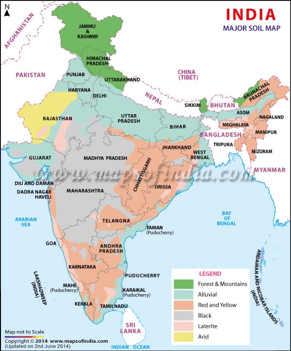
Formation: They are mainly derived from the debris brought down from the Himalayas or the silt left out by the retreating sea. Thus they are azonal soils.
Areas: Alluvial soils are widespread in the northern plains and the river valleys. Through a narrow corridor in Rajasthan, they extend into the plains of Gujarat. In the Peninsular region, they are found in deltas of the east coast and in the river valleys.
Soil texture: The alluvial soils vary in nature from sandy loam to clay. These soils are more loamy and clayey in the lower and middle Ganga plain and the Brahmaputra valley. The sand content decreases from the west to east.
Soil Colour: The colour of the alluvial soils varies from the light grey to ash grey depending on the depth of the deposition, the texture of the materials, and the time taken for attaining maturity.
Other Characteristic Features:
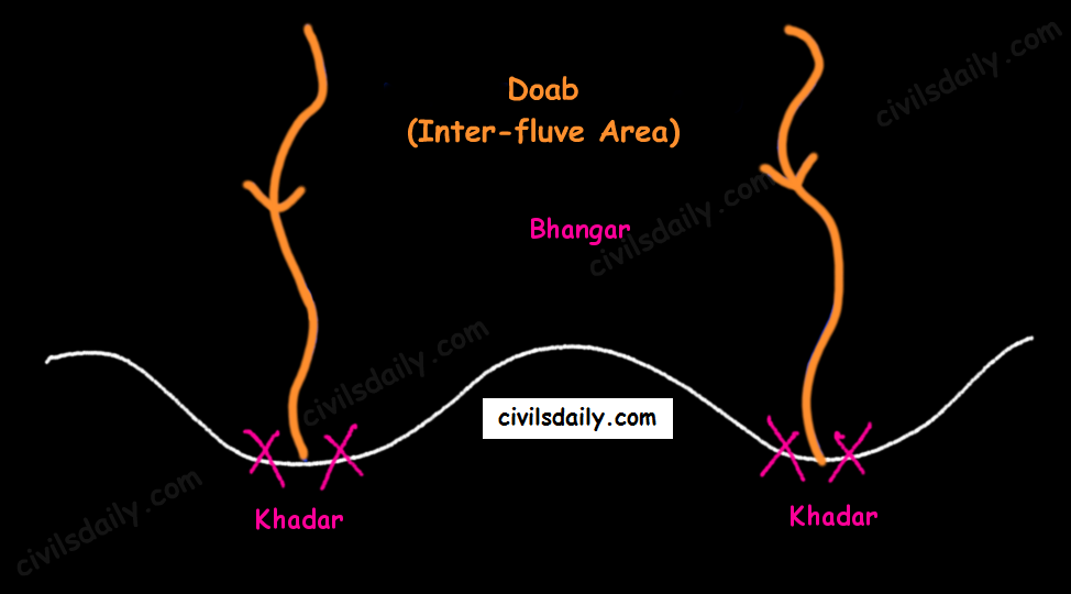
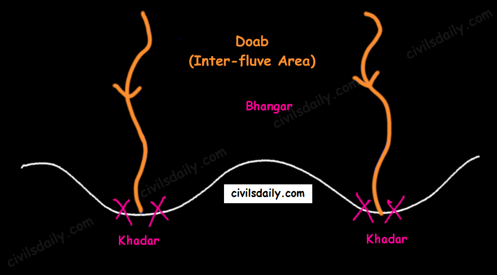
In the Upper and Middle Ganga plain, two different types of alluvial soils have developed, viz. Khadar and Bhangar.
Khadar and Bhangar
Khadar: the newer alluvium deposited by floods annually, enriches the soil by depositing fine silts, light colour, found near river beds, porous in nature. Bhangar: older alluvium, clayey, darker, has lime nodules called Kankars, found in doabs (inter-fluve areas).
Alluvial soils of the northern plains —> transported soils —>, therefore, lack humus —> lack nitrogen [That is why we need to use nitrogenous fertilisers in the northern plains!]. Exception: the Ganga-Brahmaputra delta region is rich in humus.
These soils lack in nitrogen, phosphorus and humus. However, they are generally rich in potash and lime.
The soil profile has no stratification.
Alluvial soils are intensively cultivated.
In certain areas, these soils are covered with unproductive wind-borne soil called Loess.
Limitations:
Allow water to sink into lower strata, and
Lack nitrogen (But these soils are capable of fixing nitrogen very rapidly through leguminous crops (peas, beans, cloves etc.)
These soils are locally known as the ‘Regur Soil’ or the ‘Black Cotton Soil’. Internationally, these are known as ‘tropical chernozems’. These soils are famous for the cultivation of cotton.
Formation: These have mainly formed from the Deccan Trap rocks —> Zonal Soils
Areas: These are found in the Deccan trap region. Black soil covers most of the Deccan Plateau which include parts of:
Maharashtra,
Madhya Pradesh,
Gujarat,
Andhra Pradesh and some parts of
Tamil Nadu.
Soil Texture: Black cotton soil (regur soil) is highly argillaceous i.e. clayey. It is deep and impermeable and thus has high water retention capacity.
Soil Colour: These soils are black in colour due to the presence of iron, aluminium compounds and humus.
Other Characteristic Features:
These soils are rich in minerals and known for their fertility.
The soil depth varies from place to place. It is very thick in lowlands but very thin on highlands. Also, in the upper reaches of the Godavari and the Krishna, and the northwestern part of the Deccan Plateau, the black soil is very deep.
These soils swell and become sticky when wet and develop deep wide cracks when dry. This helps in self-aeration, which leads to the absorption of nitrogen from the atmosphere. Thus, there occurs a kind of ‘self ploughing’. This aeration and oxidisation to deep levels contribute to the maintenance of the fertility of these soils. This continued fertility is favourable in the area of low rainfall for cotton cultivation even without irrigation.
Due to slow absorption and loss of moisture, the black soil retains the moisture for a very long time, which helps the crops, especially, the rain-fed ones, to sustain even during the dry season.
Chemically, the black soils are rich in lime, iron, magnesia and alumina. They also contain potash. But they lack in phosphorous, nitrogen and organic matter.
Suitable Crops: These soils are highly productive and well suited to the cultivation of cotton, pulses, millets, linseed, tobacco, sugarcane, vegetables and citrus fruits.
Note: In the southern and eastern parts of the country where rainfall is heavy, black soils often occur in close proximity to red soils. Black soils occupy valleys and low-level areas whereas the red soils occur on higher slopes and hilltops. Mixed black and red soils occur in Coimbatore, Madurai, Tirunelveli (Tamil Nadu) and Bundelkhand region.
3. Red and Yellow Soils
Locally called ‘Chalka’ in Andhra Pradesh.
Formation: These are derived from granites, gneisses and other metamorphic rocks —> Zonal Soils. These are formed under well-drained conditions.
Areas: Along the piedmont zone of the Western Ghat, a long stretch of area is occupied by red loamy soil. Yellow and red soils are also found in parts of Orissa and Chattisgarh and in the southern parts of the middle Ganga plain. They encircle the black cotton soil zone.
Soil Colour: The soil develops a reddish colour due to a wide diffusion of iron in crystalline and metamorphic rocks. It looks yellow when it occurs in a hydrated form. Often, their upper layer is red and the lower layer is yellow.
Soil Texture: Varies from sand to clay and loam.
Other Characteristic Features:
The fine-grained red and yellow soils are normally fertile, whereas coarse-grained soils found in dry upland areas are poor in fertility.
Have a porous and friable structure.
They are generally poor in nitrogen, phosphorous and humus.
These soils are airy and need irrigation for cultivation.
Intense leaching is a menace in these soil areas.
Suitable Crops: In places where irrigation facilities are available, the crops cultivated are wheat, cotton, pulses, tobacco, millets, oilseeds, potato, maize, groundnut and orchards.
4. Laterite Soil
The word laterite has been derived from the Latin word ‘Later’ which means brick. These soils when wet are as soft as butter but become hard and cloddy on drying. Therefore, these are widely cut as bricks for use in house construction.
Formation: The lateritic soils are particularly found on high flat erosion surfaces in areas of high(>200cm) and seasonal rainfall. The alternating wet and dry seasons lead to the leaching away of the siliceous matter of the rocks leaving behind the compounds of iron and aluminium. These are zonal soils.
Areas: These soils have mainly developed in the higher areas of the Peninsular plateau. The laterite soils are commonly found in Karnataka, Kerala, Tamil Nadu, Madhya Pradesh and the hilly areas of Orissa and Assam.
Soil Colour: Reddish-brown in colour due to the presence of iron oxide.
Other characteristic features:
With rain, lime and silica are leached away, and soils rich in iron oxide and aluminium compound are left behind(thus the reddish-brown colour). Also, the humus content of the soil is removed fast by bacteria that thrive well in high temperature.
These soils represent the end product of decomposition and are generally low in fertility.
The pebbly crust is the important feature of laterites which is formed due to alteration of wet and dry periods.
These soils are acidic in character due to leaching. Application of manures and fertilisers is required for making these soils fertile for cultivation.
These soils are poor in organic matter, nitrogen, phosphate and calcium, while iron oxide and potash are in excess.
Suitable crops: Red laterite soils in Tamil Nadu, Andhra Pradesh and Kerala are more suitable for tree crops like cashew nut. These soils are also suitable for tea plantations.
We discussed in detail alluvial, black, red and laterite soils. Let’s continue the discussion and move on to the next soil types!
Formation: These are derived from the disintegration of adjacent rocks and are largely blown from coastal regions and Indus valley.
Areas: Arid soils are characteristically developed in western Rajasthan, which exhibits characteristic arid topography.
Soil Colour: Arid soils range from red to brown in colour.
Soil Texture: They are generally sandy to gravelly in texture and have a high percentage of soluble salts.
Other characteristic features:
These are saline in nature. In some areas, the salt content is so high that common salt is obtained by evaporating the saline water.
Due to the dry climate, high temperature and accelerated evaporation, they lack moisture and humus.
These soils are deficient in nitrogen and humus. The phosphate and iron content is normal. These soils are rich in minerals but the main limitation is the lack of water.
The soils exhibit poorly developed horizons.
Plants are widely spaced.
Chemical weathering is limited.
Lower horizons of the soil are occupied by ‘kankar’ layers because of the increasing calcium content downwards. The ‘Kankar’ layer formation in the bottom horizons restricts the infiltration of water, and as such when irrigation is made available, the soil moisture is readily available for sustainable plant growth.
Suitable crops: If irrigated these soils give high agricultural returns. The availability of water from the Indira Gandhi canal has transformed the agricultural landscape of desert soils of western Rajasthan. These soils are mainly devoted to bajra, pulses, guar, fodder and less water requiring crops.
6. Saline and Alkaline Soils
They are also known as Usara soils. Various local names for saline soils are Reh, Kallar, and Chopan, Rakar, Thur, Karl etc.
Formation:
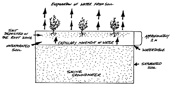
These soils have developed in areas with dry climatic conditions (in areas having a little more rainfall than the areas of desert soils) accompanied by lack of proper drainage. In this situation, salts of sodium, calcium and magnesium are deposited on the upper layer of the soil by capillary action.
In the Rann of Kuchchh, the Southwest Monsoon brings salt particles and deposits there as a crust.
These soils are also formed when saline water spreads on the land at the time of high tide in coastal areas. Also, seawater intrusions in the deltas promote the occurrence of saline soils.
Salinization also occurs because of over-irrigation (canal irrigation/groundwater use) and in areas of the high water table (as in the coastal areas of Maharashtra and Tamil Nadu). Salinity from irrigation can occur over time wherever irrigation occurs. This is because almost all water (even natural rainfall) contains some dissolved salts. When the plants use the water, the salts are left behind in the soil and eventually begin to accumulate. Also, excessive irrigation with dry climatic conditions promotes capillary action, which results in the deposition of salt on the top layer of the soil (See the following figure).
Areas: They occur in arid and semi-arid regions, and in waterlogged and swampy areas. These are more widespread in western Gujarat, deltas of the eastern coast and in Sunderban areas of West Bengal.
Soil Texture: Their texture ranges from sandy to loamy.
Other characteristic features:
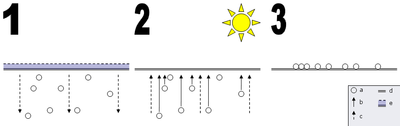
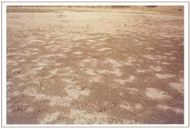
Because of capillary action, the salts are sucked up in solution to the surface and form white encrustations on the surface (See the picture below).
The salt efflorescence of calcium, magnesium and sodium makes these soils infertile.
Saline soils contain an excess of neutral soluble salts of chlorides and sulphates whereas sodic or alkali soils contain sodium carbonates/ sodium bicarbonates.
They lack in nitrogen and calcium and have low water-bearing capacity.
These soils can be reclaimed by improving drainage, by applying gypsum and/or lime, and by cultivating salt-resistant crops like barseem, dhaincha and other leguminous crops.
The saline and alkaline soils may occur in any group of soils.
Crops grown: In coastal areas, coconut trees are found in plenty in these soils. As discussed above, cultivating salt-resistant crops like bar seem, dhaincha and other leguminous crops can help in reclaiming these soils.
Note: In the areas of intensive cultivation with excessive use of irrigation, especially in areas of green revolution, the fertile alluvial soils are becoming saline. In such areas, especially in Punjab and Haryana, farmers are advised to add gypsum to solve the problem of salinity in the soil.
7. Peaty Soils
These soils are locally called Kari in Kottayam and Alleppey districts of Kerala.
Formation: These are marshy soils and are a result of waterlogging and anaerobic conditions (which leads to partial decomposition of organic matter).
Areas: They are found in the areas of heavy rainfall and high humidity, where there is a good growth of vegetation. It occurs widely in the northern part of Bihar, the southern part of Uttaranchal and the coastal areas of West Bengal, Orissa and Tamil Nadu.
Soil Colour and Texture: These soils are normally heavy and black in colour
Other characteristic features:
These soils are characterised by a rich humus and organic content.
There is a presence of iron and varying amounts of organic matter (10-40%). The organic matter in these soils may go even up to 40-50 per cent.
These soils are generally acidic in nature. But at many places, they are alkaline also.
Suitable crops: These are generally submerged during the rainy season and utilised for the cultivation of rice.
8. Forest Soils
Formation: As the name suggests, forest soils are formed in the forest areas where sufficient rainfall is available.
Areas: These are found in the forest areas of Himalayas, Sahyadris, Eastern Ghats and terai region.
Soil colour and texture: The soils vary in structure and texture depending on the mountain environment where they are formed. They are loamy and silty on valley sides and coarse-grained in the upper slopes. Their colour is dark brown.
Other Characteristics:
In the snow-bound areas of the Himalayas, they are acidic with low humus content. This is because humus is rawer at higher levels. Also, these soils are subjected to denudation due to landslides and snowfall.
The soils found in the lower valleys are fertile and rich in organic content.
Owing to sharp differences of hill slopes and climates, these soils may differ greatly even when in proximity. [Recall here the discussion on the impact of topography on soils!]
Also, these soils exist in thin layers because of their development on the mountain slopes.
These soils are poor in potash, phosphorus and lime.
Soil erosion is a major problem in these areas.
Crops grown: The slopes are used for horticulture and plantations crops like tea, coffee, spices, apple, peach etc. Rice and wheat are grown in valleys. Potatoes are grown in mostly all areas.
Drainage
The flow of water through well-defined channels is known as ‘drainage’ and the network of such channels is called a ‘drainage system’.
Types of Drainage Patterns
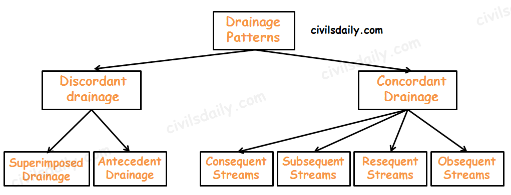
Discordant drainage
A pattern of drainage that bears no relation to the structure of the underlying rock. This may be because:
1. The drainage pattern developed on rock strata that have since been removed by erosion; a process known as superimposition. The drainage pattern thus developed is called superimposed drainage (or Epigenetic or Superinduced Drainage). Examples: The Damodar, the Subarnarekha, the Chambal, the Banas and the rivers flowing at the Rewa Plateau, rivers of eastern USA and southern France.
2. The drainage pattern was already present before a period of uplift and folding that formed the present structure. As the uplift took place, the rivers were able to cut down at approximately the same rate and so maintain their courses. This process is called antecedence and the drainage system thus developed is called antecedent drainage.
Many of the Himalayan rivers have antecedent origin i.e. these rivers existed even before the Himalayan ranges were uplifted. These rivers originate in the Tibetan side beyond the mountain ranges of Himalayas. The Indus, Satluj, Alaknanda, Gandak, Kosi, Brahmaputra all have an antecedent origin. Since these rivers are antecedent, they run transverse to the mountain ranges cutting deep V-shaped, steep-sided valleys (deep gorges).
Concordant Drainage (also called accordant drainage)
The pattern of drainage which arises from and closely follows the trends of the underlying strata is called concordant drainage.
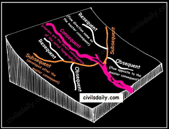
Consequent Streams: Those streams whose courses are the direct consequence of the initial topography are called consequent streams.
Subsequent Streams: These are developed after the master consequent.
Obsequent streams: These flow in opposite direction to the master consequent.
Resequent Streams: A resequent stream flows in the same direction as that of the initial consequent stream, but which develops in response to a new base level formed due to inversion of relief.
Concordant Drainage Patterns
Drainage pattern:
Drainage pattern refers to a design which a river and its tributaries form together from its source to its mouth. The drainage pattern of an area is the outcome of:
The geological time period,
Nature and structure of rocks,
Topography,
Slope,
Amount of water flowing, and
The periodicity of the flow.
Some Important Drainage Patterns:
A combination of several patterns may be found in the same drainage basin.
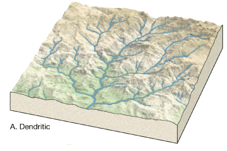
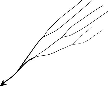
1. Dendritic: The dendritic pattern develops where the river channel follows the slope of the terrain. The drainage pattern resembling the branches of a tree is known as “dendritic” the examples of which are the rivers of northern plain. It is the most common stream pattern. A dendritic pattern develops in a terrain which has uniform lithology, and where faulting and jointing are insignificant.
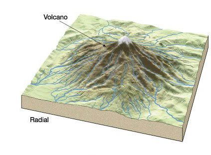
2. Radial: The radial pattern develops when streams flow in different directions from a central peak or a dome-like structure. E.g. the rivers like the Narmada, Son and Mahanadi originating from Maikal Hills flow in different directions and are good examples of a radial pattern.
Radial drainage patterns are also found/in the Girnar Hills (Kathiwar, Gujarat), and Mikir Hills of Assam.
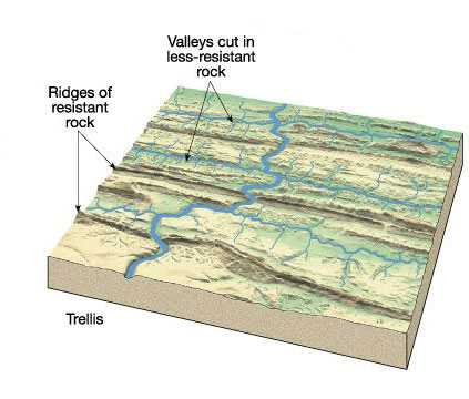
3. Trellis: When the primary tributaries of rivers flow parallel to each other and secondary tributaries join them at right angles, the pattern is known as ‘trellis’. A trellis drainage pattern develops where hard and soft rocks lie parallel to each other. For example, rivers in the upper part of the Himalayan region and in the old folded mountains of the Singhbhum (Chotanagpur Plateau) have drainage of trellis pattern. The trellis drainage pattern can also be seen in the Appalachian region of the U.S.A., where hard and soft rocks occur in parallel bands.
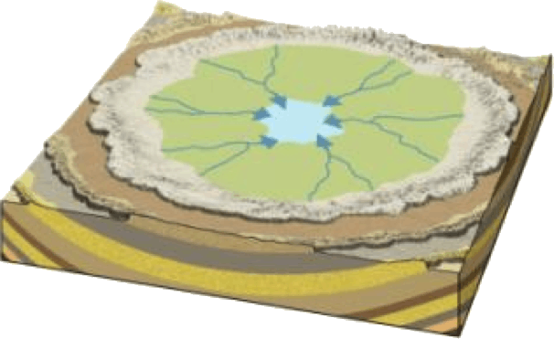
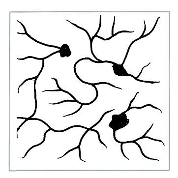
4. Centripetal: When the rivers discharge their waters from all directions in a lake or depression, the pattern is known as ‘centripetal’. This drainage pattern is also called endorheic drainage. For example, Loktak lake in Manipur.
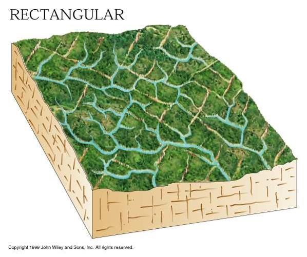
5. Rectangular: In this drainage, both the main stream and its tributaries show right-angled bends. A rectangular drainage pattern develops on a strongly jointed rocky terrain. It differs from trellis pattern drainage, since it is more irregular and its tributary streams are not as long or as parallel as in trellis drainage. Example: Colorado river (USA), streams found is the Vindhyan Mountains of India.
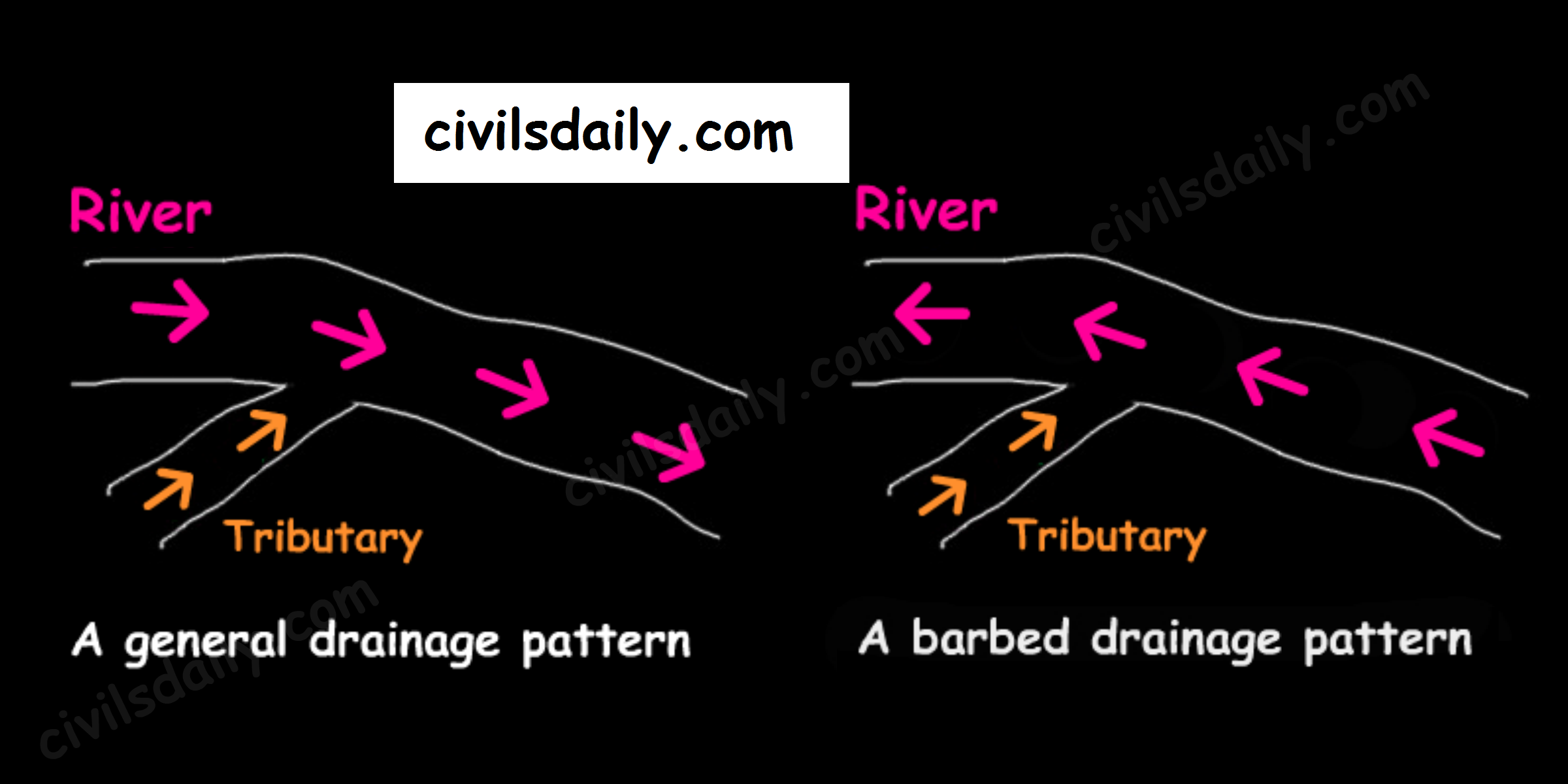
6. Barbed: If you look at the way that tributaries empty into larger rivers, you will notice that most of them flow in the same direction as the rivers they empty into. But quite a large number flow the other way. In fact, you will find stretches of some rivers where every tributary empties into the river in the “wrong” direction! Such an occurrence is known as a barbed drainage pattern.
Most barbed drainage patterns are the result of river-capture which reverses the direction of flow. However, the tributary channels continue to flow in their original direction.
The Arun River (Nepal), a tributary of the Kosi is an interesting example of barbed drainage pattern.
A Barbed Drainage Pattern
7. Annular: Annular pattern represents that part of a drainage pattern in which the subsequent streams follow the curving or arcuate courses before joining the consequent stream. These results from a partial adaptation to an underground circular structure i.e. batholiths. This is not a very common drainage pattern in India. Some examples of this are however found in Pithoragarh (Uttarakhand), Nilgiri Hills in Tamil Nadu and Kerala.
8. Parallel drainage: The drainage pattern in which the rivers flow almost parallel to each other is known as parallel drainage. The small and swift rivers originating in the Western Ghats and discharging their water into the Arabian Sea provide a good example of parallel drainage pattern in India.
9. Deranged pattern: This is an uncoordinated pattern of drainage characteristic of a region recently vacated by an ice-sheet. The picture is one of numerous water courses, lakes and marshes; some inter-connected and some in local drainage basins of their own. This type of drainage is found in the glaciated valleys of Karakoram.
Aspirants, we hope your UPSC 2024 preparation is in full swing. However, for aspirants who are facing a serious time crunch like college aspirants and working professionals, or even home-makers consistency in preparation takes a toll.
But you don’t have to compromise with your dream nor with the effectiveness of your preparation. We have this special session for you.
Sukanya Ma’am, GS Mains Program Head of CivilsDaily and UPSC Ranker, Prabhat sir will take 2 Days’ Online LIVE sessions on Mains answer writing from 0 prior knowledge and a 5-hour prep strategy for College aspirants and working professionals.
Day 1: How to Start Answer Writing for UPSC Mains even if you’ve almost 0 content? 2 Foolproof Frameworks you must master
15th April (Saturday) 2023, 7:30 P.M
Senior IAS mentor, faculty & Mains GS Program Head, Sukanya Ma’am will take a LIVE workshop where she will be demonstrating LIVE how to begin GS Mains Answer Writing for UPSC Mains, Where you find how a topper approach and solve a Mains paper.
How to start picking topics to start Answer Writing for GS Mains?
How to identify the best methods of framing answers for different ‘DIRECTIVES’ in the Mains GS questions?
Which types of questions required your opinion and what types of Questions are Current-Affairs Charged?
Which types of questions required in-depth knowledge?
Day 2 with IRPS, Prabhat Sir: Preparing for UPSC 2024 with a 5-hour prep strategy for College aspirants and working professionals
16th April (Sunday) 2023, 7:30 P.M
UPSC Topper & Super Mentor at Civilsdaily, Prabhat Sir will take a LIVE workshop where he will be discussing the ‘5-hour UPSC 2024’ strategy.
Aspirants who are either working professionals, or college-going students as of now but aiming for UPSC 2024 must not let time (or lack of) limit their preparation.
Important takeaways:
How to manage time for UPSC Preparation if you’re a working Professional? How to utilize the time, left in your hand, in the best possible way?
UPSC preparation timetable and schedule with just 5 hrs of daily study time?
How to identify those people or things that deplete your energy and waste your time?
How to break down the syllabus into small chunks, and develop an effective & workable study strategy for UPSC preparation.
How to complete the syllabus, in a short time?
How to prioritize conventional topics/subjects?
How to divide your time and keep a balance between Prelims and mains preparation?
Selective reading or studying: How to deal with the ocean of current affairs and a mountain of GS?
How to tackle Optional subject preparation, Making Notes, and improving answer writing habits in a short time
Many more untold tips and techniques that only a topper can elaborate
Concluded Successfully | How to Start Answer Writing even if you’ve almost 0 content? 2 Foolproof Frameworks| The Most Important LIVE Masterclass + QnA session by Sukanya Ma’am
Is UPSCyour 1st Choice? If ‘YES’, don’t skip this First Step towards Level-up Answer writing…
Basically, 5 skills are required to clear the UPSC exam, and the most important one is Answer Writing for GS Mains. That’s why Serious aspirants don’t compromise with any loopholes in this Preparation. Because it’s your answer writing that will decide whether you’re a suitable character for a DM/SP’s chair.
But, this skill won’t develop in a single day.
And Good News is that there is no need to become a writer or have any prior skills to write a mark-leaving answer in UPSC mains. Every year, we notice, thousands of aspirants start answer writing with almost 0 content by following 2 Foolproof Frameworks and scoring a single-digit rank for themselves.
With her 10 yr of Mains experience & proven techniques developed over time with ex-mains-students, Rankers who have cleared this exam with flying colors, and last year’s toppers, Mains Program Head, Sukanya Ma’am is taking up a webinar masterclass to help you make a comparative analysis of Proven Methods for UPSC mains answers writing from almost 0 prior knowledge. She will also give valuable insights about 2 Foolproof Frameworks you must master.
What you should expect in the 1-1 LIVE Session by Sukanya Rana Ma’am?
What are the 2 Foolproof Frameworks you must master? Universal Practical Approaches to Acquire Basic Answer Writing Skills for GS Mains.
Why is UPSC Answer Writing is far unique?
Best Methods to Start Mains Answer Writing for GS-1, GS-2, GS-3 & GS-4 for Raw Beginners and unsuccessful veterans.
How to understand the demand of a question fully and correctly before contemplating an answer for it.
How toppers develop a basic mental framework of the answer before committing anything on the paper
It is very difficult to write anything for the examiner. So, what is the best way to introduce as well as conclude your answer?
How to focus on Questions’ directives and comply with a minimum but effective requirement.
How to divide the main body of the answer into paragraphs or bullets as required.
How long should your introduction and conclusion be?
Where to and how to apply opinion-based answers!
The correct approach to writing a fact-based answerin GS-4 (Ethics & Integrity)
How to maintain ‘accuracy’, ‘brevity’, and ‘Clarity’ in each and every answer
How to do a comparative analysis of toppers’ approach. How do they create an on-demand answer and how do they follow the answer writing basic rules- ‘Brainstorming’, ‘Outlining’, ‘Idea/Argument placement, and ‘Structuring’
What Do and don’t of UPSC to keep in mind while answering writing? The most common mistakes will also be discussed.
This Spotlight is a part of our Mission Nikaalo Prelims-2023.
You can check the broad timetable of Nikaalo Prelims here
Session Details
YouTube LIVE with Parth sir – 7 PM – Prelims Spotlight Session
Evening 04 PM – Daily Mini Tests
Join our Official telegram channel for Study material and Daily Sessions Here
11th Apr 2023
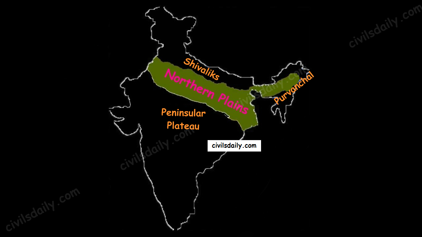
Let’s begin with the first physiographic division. It consists of:
THE HIMALAYAS, and
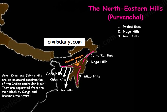
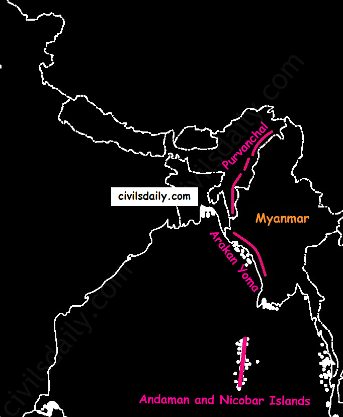
The Northeastern hills (Purvanchal).
A) The Himalayas:
The Himalayas are the highest and longest of all young fold mountains of the world. The Pamir, known as the roof of the world, connects the Himalayas with the high ranges of Central Asia.
Let’s begin by understanding how the Himalayas came into being:
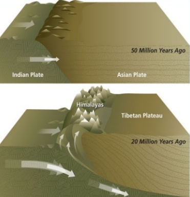
About 40 to 50 million years ago, two large landmasses, India and Eurasia, driven by plate movement, collided. As a result, the sediments accumulated in Tethys Sea (brought by rivers) were compressed, squeezed and series of folds were formed, one behind the other, giving birth to folded mountains of the Himalayas.
Recent studies show that India is still moving northwards at the rate of 5cm/year and crashing into the rest of Asia, thereby constantly increasing the height of Himalayas.
The North-South division of the Himalayas
The Himalayas consist of a series of parallel mountain ranges:
The Greater Himalayan range, which includes:
The Great Himalayas(Himadri), and
The Trans-Himalayan range
The Lesser Himalayas (or Himachal), and
The Outer Himalayas (or Shiwalik).
Formation of these ranges: The Himadri and Himachal ranges of the Himalayas have been formed much before the formation of Siwalik range. The rivers rising in the Himadri and Himachal ranges brought gravel, sand and mud along with them, which was deposited in the rapidly shrinking Tethys Sea. In the course of time, the earth movements caused the folding of these relatively fresh deposits of sediments, giving rise to the least consolidated Shiwalik range.
Characteristic Features:
Notice in the map shown above that the Himalayas form an arcuate curve which is convex to the south. This curved shape of the Himalayas is attributed to the maximum push offered at the two ends on the Indian peninsula during its northward drift. In the north-west, it was done by Aravalis and in the Northeast by the Assam ranges.
Syntaxis/ Syntaxial bends: The gently arching ranges of the Himalayan mountains on their Western and Eastern extremities are sharply bent southward in deep Knee-bend flexures that are called syntaxial bends. On both the ends, the great mountains appear to bend around a pivotal point. The western point is situated south of the Pamir where the Karakoram meets the Hindu Kush. A similar sharp, almost hairpin bend occurs on the eastern limit of Arunachal Pradesh where the strike of the mountain changes sharply from the Easterly to Southerly trend. Besides these two major bends, there are a number of minor syntaxial bends in other parts of Himalayas. Syntaxial Bends of Himalayas
The Himalayas are wider in the west than in the east. The width varies from 400 km in Kashmir to 150 km in Arunachal Pradesh. The main reason behind this difference is that the compressive force was more in the east than in the west. That is why high mountain peaks like Mount Everest and Kanchenjunga are present in the Eastern Himalayas.
The ranges are separated by deep valleys creating a highly dissected topography.
The southern slopes of the Himalayas facing India are steeper and those facing the Tibetan side are generally gentler.
Let’s take up these Himalayan mountain ranges one by one: The Himalayan Ranges | the Greater Himalayan Range, the Lesser Himalayas, the Shivaliks Indus-Tsangpo Suture Zone: It represents a belt of tectonic compression caused by the underthrusting of the Indian shield/ plate against the Tibetan mass. It marks the boundary between the Indian and Eurasian plates. The suture zone stretches from the North-Western Himalayan syntaxis bordering the Nanga Parbat to the East as far as the Namche Barwa Mountain. The Karakoram Range and the Ladakh plateau lie to the north of ITSZ and originally formed a part of the European plate. Main Central Thrust Zone: This separates the Higher Himalayas in the north from lesser Himalayas in the south. It has played an important role in the tectonic history of these mountains. Main Boundary Thrust: It is a reverse fault of great dimensions which extends all the way from Assam to Punjab and serves to separate the outer Himalayas from the lesser Himalayas.Himalayan Frontal Fault: It is a series of reverse faults that demarcates the boundary of the Shivalik from of the Himalayan province from the alluvial expanse of the Indo-Gangetic plains.
Major Faults of the Himalayas – ITSZ, MCT, MBT, HFFThe Himalayan Complex: A Cross-sectional View
Besides the longitudinal divisions, the Himalayas have been divided on the basis of regions from west to east:
These divisions have been demarcated by river valleys:
The Regional Divisions of Himalayas – the Western and Eastern Himalayas.
Punjab Himalayas:
A large portion of Punjab Himalayas is in Jammu and Kashmir and Himachal Pradesh. Hence they are also called the Kashmir and Himachal Himalaya.
Major ranges: Karakoram, Ladakh, Pir Panjal, Zaskar and Dhaola Dhar.
The general elevation falls westwards.
The Kashmir Himalayas are also famous for Karewa formations.
‘Karewas’ in Kashmiri language refer to the lake deposits, found in the flat-topped terraces of the Kashmir valley and on the flanks of the Pir Panjal range.
These deposits consist of clays, silts and sands, these deposits also show evidence of glaciation.
The occurrence of tilted beds of Karewas at the altitudes of 1500-1800m on the flanks of the Pir Panjal strongly suggests that the Himalayas were in process of uplift as late as Pliocene and Pleistocene (1.8mya to 10kyears ago)
Karewas are famous for the cultivation of Zafran, a local variety of saffron.
Kumaon Himalayas
Nepal Himalayas:
Tallest section of Himalayas
Sikkim Himalayas:
Teesta river originates near Kanchenjunga
Jelep la pass- tri-junction of India- China-Bhutan
Assam Himalayas:
The Himalayas are narrower in this region and Lesser Himalayas lie close to Great Himalayas.
Peaks: Namcha Barwa, Kula Kangri
Bengal ‘Duars’
Diphu pass- tri-junction of India- China-Myanmar
The Assam Himalayas show a marked dominance of fluvial erosion due to heavy rainfall.
The West-East Division of Himalayas
Glaciers and Snowline:
Snowline: The lower limit of perpetual snow is called the ‘snowline’. The snowline in the Himalayas has different heights in different parts, depending on latitude, altitude, amount of precipitation, moisture, slope and local topography.
1. The snowline in the Western Himalaya is at a lower altitude than in the Eastern Himalaya. E.g. while the glaciers of the Kanchenjunga in the Sikkim portion hardly move below 4000m, and those of Kumaon and Lahul to 3600m, the glaciers of the Kashmir Himalayas may descend to 2500m above the sea level.
It is because of the increase in latitude from 28°N in Kanchenjunga to 36°N in the Karakoram (Lower latitude —> warmer temperatures —> higher snowline).
Also, the Eastern Himalayas rise abruptly from the planes without the intervention of High ranges.
Though the total precipitation is much less in the western Himalayas, it all takes place in the form of snow.
2. In the Great Himalayan ranges, the snowline is at a lower elevation on the southern slopes than on the northern slopes. This is because the southern slopes are steeper and receive more precipitation as compared to the northern slopes.
Glaciers: The main glaciers are found in the Great Himalayas and the Trans-Himalayan ranges (Karakoram, Ladakh and Zaskar). The Lesser Himalayas have small glaciers, though traces of large glaciers are found in the Pir Panjal and Dhauladhar ranges. Some of the important glaciers are:
Important Glaciers and their Locations
Key differences between the Eastern and Western Himalayas:
Key Difference between the Western and Eastern Himalayas.
Important Passes in India:
A pass is a narrow gap in a mountain range which provides a passageway through the barrier.
Important Passes in India
Pir Panjal Pass – It provides the shortest and the easiest metal road between Jammu and the Kashmir Valley. But this route had to be closed down as a result of partition of the subcontinent.
Banihal Pass – It is in Jammu and Kashmir. The road from Jammu to Srinagar transversed Banihal Pass until 1956 when Jawahar Tunnel was constructed under the pass. The road now passes through the tunnel and the Banihal Pass is no longer used for road transport.
Zoji La (Pass) – It is in the Zaskar range of Jammu and Kashmir. The land route from Srinagar to Leh goes through this pass.
Shipki La (Pass) – It is in Himachal Pradesh. The road from Shimla to Tibet goes through this pass. The Satluj river flows through this pass.
Bara Lacha Pass – It is also in Himachal Pradesh. It links Mandi and Leh by road.
Rohtang Pass – It is also in Himachal Pradesh. It cuts through the Pir Panjal range. It links Manali and Leh by road.
Niti Pass – It is in Uttarakhand. The road to the Kailash and the Manasarovar passes through it.
Nathu La (Pass) – It is in Sikkim. It gives way to Tibet from Darjeeling and Chumbi valley. The Chumbi river flows through this pass.
Jalep La (Pass) – At the tri-junction of India- China-Bhutan. The Teesta river has created this pass.
B) The North-Eastern Hills and Mountains
The North-Eastern Hills (Purvanchal): Patkai Bum, Naga Hills, Mizo Hills
The Brahmaputra marks the eastern border of Himalayas. Beyond the Dihang gorge, the Himalayas bend sharply towards the south and form the Eastern hills or Purvanchal.
These hills run through the northeastern states of India.
These hills differ in scale and relief but stem from the Himalayan orogeny.
They are mostly composed of sandstones (i.e. Sedimentary rocks).
These hills are covered with dense forests.
Their elevation decreases from north to south. Although comparatively low, these hill ranges are rather forbidding because of the rough terrain, dense forests and swift streams.
Purvanchal hills are convex to the west.
These hills are composed of:
Patkai Bum – Border between Arunachal Pradesh and Myanmar
Naga Hills
Manipuri Hills – Border between Manipur and Myanmar
Mizo Hills.
Patkai Bum and Naga Hills form the watershed between India and Myanmar.
Extension of Purvanchal continues in Myanmar as Arakan Yoma –then Andaman and Nicobar Islands.
Arakan Yoma – An Extension of Purvanchal in Myanmar
The importance of Himalayan Region:
Climatic Influence – The altitude of the Himalayas, their sprawl and extension intercept the summer monsoon. They also prevent the cold Siberian air masses from entering into India.
Defence
Source of perennial rivers
Source of fertile soils
Generation of hydroelectricity
Forest wealth
Orchards
Minerals – The Himalayan region is rich in minerals e.g. gold, silver, copper, lead etc. are known to occur. Coal is found in Kashmir. But at the present level of technological advancement, it is not possible to extract these minerals. Also, it is not economically viable.
Tourism
Pilgrimage
NORTHERN PLAINS
Location and Extent:
Northern plains are the youngest physiographic feature in India. They lie to the south of the Shivaliks, separated by the Himalayan Frontal Fault (HFF). The southern boundary is a wavy irregular line along the northern edge of the Peninsular India. On the eastern side, the plains are bordered by the Purvanchal hills.
The Physiographic Divisions of India: the Northern Plains
Formation of Northern Plains:
Due to the uplift of the Himalayas in the Tethys Sea, the northern part of the Indian Peninsula got subsided and formed a large basin.
That basin was filled with sediments from the rivers which came from the mountains in the north and from the peninsula in the south. These extensive alluvial deposits led to the formation of the northern plains of India.
Chief Characteristics:
The northern plain of India is formed by three river systems, i.e. the Indus, the Ganga and the Brahmaputra; along with their tributaries.
The northern plains are the largest alluvial tract of the world. These plains extend approximately 3200 km from west to east.
The average width of these plains varies between 150 and 300 km. In general, the width of the northern plains increases from east to west (90-100km in Assam to about 500km in Punjab).
The exact depth of alluvium has not yet been fully determined. According to recent estimates, the average depth of alluvium in the southern side of the plain varies between 1300-1400m, while towards the Shiwaliks, the depth of alluvium increases. The maximum depth of over 8000m has been reached in parts of Haryana.
The extreme horizontality of this monotonous plain is its chief characteristic (200m – 291m). The highest elevation of 291 m above mean sea level near Ambala forms a watershed between the Indus system and Ganga system).
The monotony of the physical landscape is broken at the micro-level by the river bluffs, levees etc.
[Floodplain – That part of a river valley, adjacent to the channel, over which a river flows in times of a flood.
Levee – An elevated bank flanking the channel of the river and standing above the level of the flood plain.
Bluff – A river cut cliff or steep slope on the outside of a meander. A line of bluffs often marks the edge of a former floodplain.]
From the north to the south, the northern plains can be divided into three major zones:
The Bhabar
The Tarai
The alluvial plains.
The alluvial plains can be further divided into the Khadar and the Bhangar as illustrated below:
Geomorphology of the Northern Plains
Let’s understand these divisions one by one:
Bhabar:
Bhabar is a narrow belt (8-10km wide) which runs in the west-east direction along the foot of the Himalayas from the river Indus to Teesta. Source
Rivers which descend from the Himalayas deposit their load along the foothills in the form of alluvial fans.
These fans consisting of coarser sediments have merged together to build up the piedmont plain/the Bhabar.
The porosity of the pebble-studded rock beds is very high and as a result, most of the streams sink and flow underground. Therefore, the area is characterized by dry river courses except in the rainy season.
The Bhabar track is not suitable for cultivation of crops. Only big trees with large roots thrive in this region.
The Bhabar belt is comparatively narrow in the east and extensive in the western and north-western hilly region.
Tarai:
It is a 10-20 km wide marshy region in the south of Bhabar and runs parallel to it.
The Tarai is wider in the eastern parts of the Great Plains, especially in the Brahmaputra valley due to heavy rainfall.
It is characterized by the re-emergence of the underground streams of the Bhabar belt.
The reemerged water transforms large areas along the rivers into badly drained marshy lands.
Once covered with dense forests, most of the Tarai land (especially in Punjab, Uttar Pradesh and Uttarakhand) has been reclaimed and turned into agricultural land over a period of time.
Bhangar:
It is the older alluvium along the river beds forming terraces higher than the flood plain.
Dark in colour, rich in humus content and productive.
The soil is clayey in composition and has lime modules (called kankar)
Found in doabs (inter-fluve areas)
‘The Barind plains’ in the deltaic region of Bengal and the ‘bhur formations’ in the middle Ganga and Yamuna doab are regional variations of Bhangar. [Bhur denotes an elevated piece of land situated along the banks of the Ganga river especially in the upper Ganga-Yamuna Doab. This has been formed due to accumulation of wind-blown sands during the hot dry months of the year]
In relatively drier areas, the Bhangar also exhibits small tracts of saline and alkaline efflorescence known as ‘Reh’, ‘Kallar’ or ‘Bhur’. Reh areas have spread in recent times with an increase in irrigation (capillary action brings salts to the surface).
May have fossil remains of even those plants and animals which have become extinct.
Khadar:
Composed of newer alluvium and forms the flood plains along the river banks.
Light in colour, sandy in texture and more porous.
Found near the riverbeds.
A new layer of alluvium is deposited by river flood almost every year. This makes them the most fertile soils of Ganges.
In Punjab, the Khadar rich flood plains are locally known as ‘Betlands’ or ‘Bets’.
The rivers in Punjab-Haryana plains have broad flood plains of Khadar flanked by bluffs, locally known as Dhayas. These bluffs are as high as 3metres.
Northern Plain: Regional Divisions
The Regional Divisions of the Northern Plains: Punjab, Ganga and the Brahmaputra Plains.
Punjab Plains:
The Punjab plains form the western part of the northern plain.
In the east, the Delhi-Aravalli ridge separates it from the Ganga plains.
This is formed by the Indus and its tributaries; like Jhelum, Chenab, Ravi, Beas and Sutlej. A major portion of these plains is in Pakistan.
It is divided into many Doabs (do-“two” + ab- “water or river” = “a region or land lying between and reaching to the meeting of the two rivers”). Khadar and Bhangar
Important features:
Khadar rich flood plains known as ‘Betlands’ or ‘Bets’.
The rivers in Punjab-Haryana plains have broad flood plains of Khadar flanked by bluffs, locally known as Dhayas.
The northern part of this plane adjoining the Shivalik hills has been heavily eroded by numerous streams, which are called Chhos.
The southwestern parts, especially the Hisar district is sandy and characterized by shifting sand-dunes.
Ganga Plains:
The Ganga plains lie between the Yamuna catchment in the west to the Bangladesh border in the East.
The lower Ganga plain has been formed by the down warping of a part of Peninsular India between Rajmahal hills and the Meghalaya plateau and subsequent sedimentation by the Ganga and Brahmaputra rivers.
The main topographical variations in these plains include Bhabar, Tarai, Bhangar, Khadar, levees, abandoned courses etc.
Almost all the rivers keep on shifting their courses making this area prone to frequent floods. The Kosi river is very notorious in this respect. It has long been called the ‘Sorrow of Bihar’.
The northern states, Haryana, Delhi, UP, Bihar, part of Jharkhand and West Bengal in the east lie in the Ganga plains.
The Ganga-Brahmaputra delta: the largest delta in the world. A large part of the coastal delta is covered tidal forests called Sunderbans. Sunderbans, the largest mangrove swamp in the world gets its name from the Sundari tree which grows well in marshland. It is home to the Royal Tiger and crocodiles.
Brahmaputra Plains:
This plain forms the eastern part of the northern plain and lies in Assam.
Its western boundary is formed by the Indo-Bangladesh border as well as the boundary of the lower Ganga Plain. Its eastern boundary is formed by Purvanchal hills.
The region is surrounded by high mountains on all sides, except on the west.
The whole length of the plain is traversed by the Brahmaputra.
The Brahmaputra plains are known for their riverine islands (due to the low gradient of the region) and sand bars.
The innumerable tributaries of the Brahmaputra river coming from the north form a number of alluvial fans. Consequently, the tributaries branch out in many channels giving birth to river meandering leading to the formation of bill and ox-bow lakes.
There are large marshy tracts in this area. The alluvial fans formed by the coarse alluvial debris have led to the formation of terai or semi-terai conditions.
Significance of this region:
The plains constitute less than one-third of the total area of the country but support over 40 percent of the total population of the country.
Fertile alluvial soils, flat surface, slow-moving perennial rivers and favourable climate facilitate an intense agricultural activity.
The extensive use of irrigation has made Punjab, Haryana and western part of Uttar Pradesh the granary of India (Prairies are called the granaries of the world).
Cultural tourism: Several sacred places and centres of pilgrimage are situated in these plains e.g. Haridwar, Amritsar, Varanasi, Allahabad, Bodh Gaya etc.
The sedimentary rocks of plains have petroleum and natural gas deposits.
The rivers here have very gentle gradients which make them navigable over long distances.
PENINSULAR PLATEAU
A. Location and Extent
The Peninsular Plateau lies to the south of the Northern Plains of India.
It is bordered on all sides by the hill ranges:
Delhi ridge in the north-west (extension of Aravalis),
the Rajmahal Hills in the east,
Gir range in the west, and
the Cardamom Hills in the south constitute the outer extent of the peninsular plateau.
The Physiographic Divisions of India | The Peninsular Plateau
Outlier:
Shillong and Karbi-Anglong plateau.
Note: Kutchch Kathiawar region – The region, though an extension of Peninsular plateau (because Kathiawar is made of the Deccan Lava and there are tertiary rocks in the Kutch area), they are now treated as an integral part of the Western Coastal Plains as they are now levelled down.
The Garo-Rajmahal Gap:
The two disconnected outlying segments of the plateau region are seen in the Rajmahal and Garo-Khasi Jaintia hills.
It is believed that due to the force exerted by the northeastward movement of the Indian plate at the time of the Himalayan origin, a huge fault was created between the Rajmahal hills and the Meghalaya plateau
Later, this depression got filled up by the deposition activity of the numerous rivers.
As a result, today the Meghalaya and Karbi Anglong plateau stand detached from the main Peninsular Block.
Geological History and Features:
The peninsular plateau is a tableland which contains igneous and metamorphic rocks. It is one of the oldest and the most stable landmass of India.
In its otherwise stable history, the peninsula has seen a few changes like:
Gondwana Coal Formation.
Narmada-Tapi rift valley formation.
Basalt Lava eruption on Deccan plateau:
During its journey northward after breaking off from the rest of Gondwana, the Indian Plate passed over a geologic hotspot, the Réunion hotspot, which caused extensive melting underneath the Indian Craton. The melting broke through the surface of the craton in a massive flood basalt event, creating what is known as the Deccan Traps (Its various features have been discussed in the later portion of the article).
Chief Characteristics:
The entire peninsular plateau region is an aggregation of several smaller plateaus and hill ranges interspersed with river basins and valleys. The Chhattisgarh plain occupied by the dense Dandakaranya forests is the only plain in the peninsula.
1. General elevation and flow of rivers:
The average elevation is 600-900 metres.
The general elevation of the plateau is from the west to the east, which is also proved by the pattern of the flow of rivers.
Barring Narmada and Tapti all the major rivers lying to the south of the Vindhyas flow eastwards to fall into the Bay of Bengal.
The westward flow of Narmada and Tapi is assigned to the fact that they have been flowing through faults or rifts which were probably caused when the Himalayas began to emerge from the Tethys Sea of the olden times.
2. Some of the important physiographic features of this region are:
Tors – Prominent, isolated mass of jointed, weathered rock, usually granite.
Series of hummocky hills and wall-like quartzite dykes offering natural sites for water storage.
Broad and shallow valleys and rounded hills
Ravines and gorges: The northwestern part of the plateau has a complex relief of ravines and gorges. The ravines of Chambal, Bhind and Morena are some of the well-known examples.
3. The Deccan Traps:
One of the most important features of the peninsular plateau is the black soil area in the western and northwestern part of the plateau, which is known as the Deccan Trap.
From the end of the Cretacious until the beginning of the Eocene, numerous fissure-type eruptions took place in the north-western part of the Deccan plateau. It is believed that the lava outpourings were more than the mass comprising the present-day Himalayas.
It covers a major portion of the Maharashtra plateau and parts of Gujarat, northern Karnataka and Malwa plateau. Some parts of Tamil Nadu, Andhra Pradesh, UP, and Jharkhand have some outliers of Deccan trap.
Basalt is the main rock of the region.
The region has black cotton soil as a result of weathering of this lava material and this soil is one of the finest examples of the parent material controlled soils.
Physiographic Divisions:
On the basis of prominent relief features, the peninsular plateau can be divided into three broad groups:
The Central Highlands
The Deccan Plateau
The Northeastern Plateau.
Physiographic Divisions and Important Mountain Ranges of the Peninsular Plateau
Let’s take up these divisions one by one:
1. The Central Highlands
The northern segment of the peninsular plateau is known as the Central Highlands.
Location:
North of Narmada river.
They are bounded to the west by the Aravallis.
Satpura ranges (formed by a series of scarped plateaus) lie in the South.
General Elevation: 700-1,000 m above the mean sea level and it slopes towards the north and northeastern directions.
These highlands consist of the:
Marwar upland – to the east of Aravallis in Rajasthan
A rolling plain carved by Banas river. [Rolling Plain: ‘Rolling plains’ are not completely flat; there are slight rises and fall in the landform. Ex: Prairies of USA]
The average elevation is 250-500 m above sea level.
Madhya Bharat Pathar – to the east of Marwar upland.
Malwa plateau – It lies in Madhya Pradesh between Aravali and Vindhyas. It is composed of the extensive lava flow and is covered with black soils.
Bundelkhand plateau – It lies along the borders of UP and MP. Because of intensive erosion, semi-arid climate and undulating area, it is unfit for cultivation.
Baghelkhand plateau – It lies to the east of the Maikal range.
Chhotanagpur plateau – the northeast part of Peninsular plateau.
It Includes Jharkhand, parts of Chhattisgarh and West Bengal.
This plateau consists of a series of step-like sub-plateaus (locally called peatlands – high-level plateau). It is thus famous as the Patland plateau and known as Ruhr of India.
Rajmahal Hills are the northeastern projection of Chhota Nagpur Plateau.
It is a mineral-rich plateau.
The extension of the Peninsular plateau can be seen as far as Jaisalmer in the West, where it has been covered by the longitudinal sand ridges and crescent-shaped sand dunes called barchans.
This region has undergone metamorphic processes in its geological history, which can be corroborated by the presence of metamorphic rocks such as marble, slate, gneiss, etc.
Most of the tributaries of the river Yamuna have their origin in the Vindhyan and Kaimur ranges. Banas is the only significant tributary of the river Chambal that originates from the Aravalli in the west.
Physiographic Divisions of the Peninsular Plateau – the Central Highlands and the Deccan Plateau
2. The Deccan Plateau
The Deccan Plateau lies to the south of the Narmada River and is shaped as an inverted triangle.
It is bordered by:
The Western Ghats in the west,
The Eastern Ghats in the east,
The Satpura, Maikal range and Mahadeo hills in the north.
It is volcanic in origin, made up of horizontal layers of solidified lava forming trap structure with step-like appearance. The sedimentary layers are also found in between the layers of solidified lava, making it inter–trapping in structure.
Most of the rivers flow from west to east.
The plateau is suitable for the cultivation of cotton; home to rich mineral resources and a source to generate hydroelectric power.
The Deccan plateau can be subdivided as follows:
The Maharashtra Plateau – it has typical Deccan trap topography underlain by basaltic rock, the regur.
The Karnataka Plateau (also known as Mysore plateau) – divided into western hilly country region of ‘Malnad’ and plain ‘Maidan’
Telangana Plateau
3. The Northeastern Plateau:
The Meghalaya (or Shillong) plateau is separated from peninsular rock base by the Garo-Rajmahal gap.
Shillong (1,961 m) is the highest point of the plateau.
The region has the Garo, Khasi, Jaintia and Mikir (Rengma) hills.
An extension of the Meghalaya plateau is also seen in the Karbi Anglong hills of Assam.
The Meghalaya plateau is also rich in mineral resources like coal, iron ore, sillimanite, limestone and uranium.
This area receives maximum rainfall from the south-west monsoon. As a result, the Meghalaya plateau has a highly eroded surface. Cherrapunji displays a bare rocky surface devoid of any permanent vegetation cover.
Hill ranges of the peninsula:
Most of the hills in the peninsular region are of the relict type (residual hills). They are the remnants of the hills and horsts formed many million years ago (horst: uplifted block; graben: subsided block).
The plateaus of the Peninsular region are separated from one another by these hill ranges and various river valleys.
Hill Ranges of the Peninsula
1. The Aravalli Mountain Range:
It is a relic of one of the oldest fold mountains of the world.
Its general elevation is only 400-600 m, with few hills well above 1,000 m.
At present, it is seen as a discontinuous ridge from Delhi to Ajmer and rising up to 1722m (Gurushikhar peak in Mount Abu) and thence southward.
It is known as ‘Jarga’ near Udaipur and ‘Delhi Ridge’ near Delhi.
Dilwara Jain Temple, the famous Jain temple is situated on Mt. Abu.
2. Vindhyan Ranges:
They rise as an escarpment running parallel to the Narmada-Son valley.
General elevation: 300 to 650 m.
Most of them are made up of sedimentary rocks of ancient ages.
They act as a watershed between Gangetic and peninsular river systems.
3. Satpura ranges:
Satpura range is a series of seven mountains (‘Sat’ = seven and ‘pura’ = mountains).
The seven mountain ranges or folds of Satpura’s are:
Maikal Hills
Mahadeo Hills near Pachmarhi
Kalibhit
Asirgarh
Bijagarh
Barwani
Arwani which extends to Rajpipla Hills in Eastern Gujarat.
Satpura ranges run parallel between Narmada and Tapi, parallel to Maharashtra-MP border.
Dhupgarh (1,350 m) near Pachmarhi on Mahadev Hills is the highest peak of the Satpura Range.
Amarkantak (1,127 m) is another important peak. Amarkantak is the highest peak of the Maikal Hills from where two prominent rivers – the Narmada and the Son originate.
Note that three rivers originate from the three sides of Maikal hills (as shown in the following map) but, from Amarkantak, only two rivers (the Narmada and the Son) originate (and not Mahanadi).
The Satpura Mountain Range
4. Western and Eastern Ghats:
The Western Ghats:
These are a faulted part of the Deccan plateau running parallel from the Tapi valley to a little north of Kanyakumari (1600km). Their western slope is like an escarpment while eastern slope merges gently with the plateau.
Their average elevation is about 1,500 m with the height increasing from north to south.
The Eastern Ghats are in the form of residual mountains which are not regular but broken at intervals.
The Eastern and the Western Ghats meet each other at the Nilgiri hills.
A brief comparison between them:
Differences between the Western and Eastern Ghats.A cross-sectional view through the Peninsular Plateau showing sharp relief contrast between the western and eastern margins
Note: The Western Ghats are continuous and can be crossed through passes only. There are four main passes which have developed in the Western Ghats. These are:
Thal Ghat – It links Nasik to Mumbai.
Bhor Ghat – It links Mumbai to Pune.
Pal Ghat – This pass is located between the Nilgiris and the Annamalai mountains. It is in Kerala and connects Kochi and Chennai.
Senkota Pass – This pass located between the Nagercoil and the Cardamom hills links Thiruvananthapuram and Madurai.
For the geographical location of these passes, see the following map:
Important Passes in India
Significance of the Peninsular Region:
Rich in mineral resources: The peninsular region of India is rich in both metallic and non-metallic minerals. About 98% of the Gondwana coal deposits of India are found in the peninsular region.
Agriculture: Black soil found in a substantial part of the peninsula is conducive for the cultivation of cotton, maize , citrus fruits etc. Some areas are also suitable for the cultivation of tea, coffee, groundnut etc.
Forest Products: Apart from teal, sal wood and other forest products, the forests of Western and Eastern Ghats are rich in medicinal plants and are home to many wild animals.
Hydel Power: many rivers, which have waterfalls. They help in the generation of hydroelectric power.
Tourism: There are numerous hill stations and hill resorts like Ooty, Mahabaleshwar, Khandala, etc.
THE INDIAN DESERT
The Indian desert is also known as the Thar Desert or the Great Indian Desert.
Location and Extent:
Location – To the north-west of the Aravali hills.
It covers Western Rajasthan and extends to the adjacent parts of Pakistan.
The Physiographic Divisions of India | The Indian Desert
Geological History and Features
Most of the arid plain was under the sea from Permo-Carboniferous period and later it was uplifted during the Pleistocene age. This can be corroborated by the evidence available at wood fossils park at Aakal and marine deposits around Brahmsar, near Jaisalmer (The approximate age of the wood fossils is estimated to be 180 million years).
The presence of dry beds of rivers (eg Saraswati) indicates that the region was once fertile.
Geologically, the desert area is a part of the peninsular plateau region but on the surface, it looks like an aggradational plain.
Chief Characteristics:
The desert proper is called the Marusthali (dead land) as this region has an arid climate with low vegetation cover. In general, the Eastern part of the Marushthali is rocky, while its western part is covered by shifting sand dunes.
Bagar: Bagar refers to the semi-desert area which is west of Aravallis. Bagar has a thin layer of sand. It is drained by Luni in the south whereas the northern section has a number of salt lakes.
The Rajasthan Bagar region has a number of short seasonal streams which originate from the Aravallis. These streams support agriculture in some fertile patches called Rohi.
Even the most important river ‘Luni’ is a seasonal stream. The Luni originates in the Pushkar valley of the Aravalli Range, near Ajmer and flows towards the southwest into the Rann of Kutch.
The region north of Luni is known as the Thali or sandy plain.
There are some streams which disappear after flowing for some distance and present a typical case of inland drainage by joining a lake or playa e.g. the Sambhar Lake. The lakes and the playas have brackish water which is the main source of obtaining salt.
Well pronounced desert land features:
Sand dunes: It is a land of undulating topography dotted with longitudinal dunes, transverse dunes and barchans. [Barchan – A crescent-shaped sand dune, the horns of which point away from the direction of the dominant wind; Longitudinal dune – A sand dune with its crest running parallel to the direction of prevailing wind]
Of the total coastline of India (7517 km), that of the peninsula is 6100 km between the peninsular plateau and the sea. The peninsular plateau of India is flanked by narrow coastal plains of varied width from north to south.
The Physiographic Divisions of India | The Coastal Plains
On the basis of the location and active geomorphologic processes, these can be broadly divided into two parts:
The western coastal plains
The eastern coastal plains.
We now take them up one by one:
The Western Coastal Plain
1. Extent: The Western Coastal Plains are a thin strip of coastal plains with a width of 50 km between the Arabian Sea and the Western Ghats.
2. Subdivisions: Extending from the Gujarat coast in the north to the Kerala coast in the south, the western coast may be divided into following divisions:
Kachchh and Kathiawar coast in Gujarat,
Konkan coast in Maharashtra,
Goan Coast in Karnataka, and
Malabar coast in Kerala
Note: Kutch and Kathiawar, though an extension of Peninsular plateau (because Kathiawar is made of the Deccan Lava and there are tertiary rocks in the Kutch area), they are still treated as an integral part of the Western Coastal Plains as they are now levelled down.
Subdivisions of the eastern and Western Coastal Plains
3. A coastline of submergence: The western coastal plains are an example of the submerged coastal plain. It is believed that the city of Dwaraka which was once a part of the Indian mainland situated along the west coast is submerged underwater.
4. Characteristic Features:
The western coastal plains are narrow in the middle and get broader towards north and south. Except for the Kachchh and Kathiawar coastal region, these are narrower than their eastern counterpart.
The coast is straight and affected by the South-West Monsoon winds over a period of six months. The western coastal plains are thus wetter than their eastern counterpart.
The western coast being more indented than the eastern coast provides natural conditions for the development of ports and harbours. Kandla, Mazagaon, JLN port Navha Sheva, Marmagao, Mangalore, Cochin, etc. are some of the important natural ports located along the west coast.
The western coastal plains are dotted with a large number of coves (a very small bay), creeks (a narrow, sheltered waterway such as an inlet in a shoreline or channel in a marsh) and a few estuaries. The estuaries, of the Narmada and the Tapi are the major ones.
The rivers flowing through this coastal plain do not form any delta. Many small rivers descend from the Western Ghats making a chain of waterfalls.
The Kayals – The Malabar coast has a distinguishing feature in the form of ‘Kayals’ (backwaters). These backwaters are the shallow lagoons or the inlets of the sea and lie parallel to the coastline. These are used for fishing, inland navigation and are important tourist spots. The largest of these lagoons is the Vembanad lake. Kochi is situated on its opening into the sea.
The Eastern Coastal Plain
1. Extent: The Eastern Coastal Plains is a strip of coastal plain with a width of 100 – 130 km between the Bay of Bengal and the Eastern Ghats
2. Subdivisions: It can be divided into two parts:
Northern Circar: The northern part between Mahanadi and Krishna rivers. Additionally, the coastal tract of Odisha is called the Utkal plains.
Coromandel Coast (or Payan Ghat): The southern part between Krishna and Kaveri rivers.
3. A coastline of emergence: The eastern coastal plain is broader and is an example of an emergent coast.
4. Characteristic features:
The eastern coastal plains are wider and drier resulting in shifting sand dunes on its plains.
There are well-developed deltas here, formed by the rivers flowing eastward in to the Bay of Bengal. These include the deltas of the Mahanadi, the Godavari, the Krishna and the Kaveri.
Because of its emergent nature, it has less number of ports and harbours. The continental shelf extends up to 500 km into the sea, which makes it difficult for the development of good ports and harbours.
Chilika lake is an important feature along the eastern coast. It is the largest saltwater lake in India.
Significance of the Coastal Plains region:
These plains are agriculturally very productive. The western coast grows specialized tropical crops while eastern coasts witnessed a green revolution in rice.
The delta regions of eastern coastal plains have a good network of canals across the river tributaries.
Coastal plains are a source of salt, monazite (used for nuclear power) and mineral oil and gas as well as centres of fisheries.
Although lacking in adequate natural harbours, with a number of major and minor ports, coastal plains are centres of commerce and have attracted dense human settlements.
The coastal regions of India are noted for tourist centres, fishing and salt making.
THE ISLANDS
There are two major island groups in India
The island groups of Bay of Bengal: Andaman & Nicobar Islands
The island groups of Arabian Sea: Lakshadweep and Minicoy Islands
The Physiographic Divisions of India | The Islands
Let’s take these up one by one:
Andaman & Nicobar Islands:
Also called the emerald islands.
Location and Extent:
These are situated roughly between 6°N-14°N and 92°E -94°E.
The most visible feature of the alignment of these islands is their narrow longitudinal extent.
These islands extend from the Landfall Island in the north (in the Andamans) to the Indira Point (formerly known as Pygmalion Point and Parsons Point) in the south (In the Great Nicobar).
Origin: The Andaman and Nicobar islands have a geological affinity with the tertiary formation of the Himalayas, and form a part of its southern loop continuing southward from the Arakan Yoma.
The entire group of islands is divided into two broad categories:
The Andaman in the north, and
The Nicobar in the south.
They are separated by a water body which is called the Ten-degree channel.
The Andaman islands are further divided into:
Great Andamans
North Andaman
Middle Andaman
South Andaman
Little Andaman
Little Andaman is separated from the Great Andamans by the Duncan Passage.
The Andaman and Nicobar Islands
Chief Characteristics:
These are actually a continuation of Arakan Yoma mountain range of Myanmar and are therefore characterized by hill ranges and valleys along with the development of some coral islands.
Some smaller islands are volcanic in origin e.g. the Barren island and the Narcondam Island. Narcondam is supposed to be a dormant volcano but Barren perhaps is still active.
These islands make an arcuate curve, convex to the west.
These islands are formed of granitic rocks.
The coastal line has some coral deposits and beautiful beaches.
These islands receive convectional rainfall and have an equatorial type of vegetation.
These islands have a warm tropical climate all year round with two monsoons.
The Saddle peak (North Andaman – 738 m) is the highest peak of these islands.
The Great Nicobar is the largest island in the Nicobar group and is the southernmost island. It is just 147 km away from the Sumatra island of Indonesia.
Lakshadweep Islands:
These islands were earlier (before 1st November 1973) known as Laccadive, Minicoy and Amindivi Islands.
Location:
These are scattered in the Arabian Sea between 8°N-12°N and 71°E -74°E longitude.
These islands are located at a distance of 280 km-480 km off the Kerala coast.
Origin: The entire island group is built of coral deposits.
Important islands:
Amindivi and Cannanore islands in the north.
Minicoy (lies to the south of the nine-degree channel) is the largest island with an area of 453 sq. km.
These consist of approximately 36 islands of which 11 are inhabited.
These islands, in general, have a north-south orientation (only Androth has an East-West orientation.
These islands are never more than 5 metres above sea level.
These islands have calcium-rich soils- organic limestones and scattered vegetation of palm species.
One typical feature of these islands is the formation of the crescentic reef in the east and a lagoon in the west.
Their eastern seaboard is steeper.
The Islands of this archipelago have storm beaches consisting of unconsolidated pebbles, shingles, cobbles and boulders on the eastern seaboard.
The islands form the smallest Union Territory of India.
Other than the above mentioned two major groups, the important islands are:
Majauli: in Assam. It is:
The world’s largest freshwater (Brahmaputra river) island.
India’s first island district
Salsette: India’s most populous island. Mumbai city is located on this island.
Sriharikota: A barrier island. On this island is located the satellite launching station of ISRO.
Aliabet: India’s first off-shore oil well site (Gujarat); about 45 km from Bhavnagar, it is in the Gulf of Khambat.
New Moore Island: in the Ganga delta. It is also known as Purbasha island. It is an island in the Sunderban deltaic region and it was a bone of contention between India and Bangladesh. In 2010, it was reported to have been completely submerged by the rising seawater due to Global warming.
Pamban Island: lies between India and Sri Lanka.
Abdul Kalam Island: The Wheeler Island near the Odisha coast was renamed as Abdul Kalam island in 2015. It is a missile launching station in the Bay of Bengal. The first successful land-to-land test of the Prithvi Missile was conducted from the mainland and it landed on the then uninhabited ‘Wheeler Island’ on November 30, 1993.
This Spotlight is a part of our Mission Nikaalo Prelims-2023.
You can check the broad timetable of Nikaalo Prelims here
Session Details
YouTube LIVE with Parth sir – 1 PM – Prelims Spotlight Session
Evening 04 PM – Daily Mini Tests
Join our Official telegram channel for Study material and Daily Sessions Here
10th Apr 2023
Important Seas and Mountain Ranges in the World
Tasman Sea
The Tasman Sea is a marginal sea of the South Pacific Ocean, situated between Australia and New Zealand. It measures about 2,000 kilometres (1,200 mi) across and about 2,800 kilometres (1,700 mi) from north to south. The sea was named after the Dutch explorer Abel Janszoon Tasman, who was the first recorded European to encounter New Zealand and Tasmania. The British explorer Captain James Cook later extensively navigated the Tasman Sea in the 1770s as part of his first voyage of exploration.
Persian Gulf
This inland sea of some 251,000 square kilometres (96,912 sq mi) is connected to the Gulf of Oman in the east by the Strait of Hormuz; and its western end is marked by the major river delta of the Shatt al-Arab, which carries the waters of the Euphrates and the Tigris. Its length is 989 kilometres (615 miles), with Iran covering most of the northern coast and Saudi Arabia most of the southern coast. The Persian Gulf is about 56 km (35 mi) wide at its narrowest, in the Strait of Hormuz. The waters are overall very shallow, with a maximum depth of 90 metres (295 feet) and an average depth of 50 metres (164 feet).
Countries with a coastline on the Persian Gulf are (clockwise, from the north): Iran; Oman’s exclave Musandam; the United Arab Emirates; Saudi Arabia; Qatar, on a peninsula off the Saudi coast; Bahrain, on an island; Kuwait; and Iraq in the northwest. Various small islands also lie within the Persian Gulf, some of which are the subject of territorial disputes between the states of the region.
Mediterranean Sea The Mediterranean Sea is a sea connected to the Atlantic Ocean, surrounded by the Mediterranean Basin and almost completely enclosed by land: on the north by Southern Europe and Anatolia, on the south by North Africa, and on the east by the Levant. The sea is sometimes considered a part of the Atlantic Ocean, although it is usually identified as a separate body of water.
The countries with coastlines on the Mediterranean Sea are
Albania
Algeria
Bosnia and Herzegovina
Croatia
Cyprus
Egypt
France
Greece
Israel
Italy
Lebanon
Libya
Malta
Morocco
Monaco
Montenegro
Slovenia
Spain
Syria
Tunisia
Tukey
In addition, the Gaza Strip (“Palestine” has been associated with the geographical area that currently covers the State of Israel, the West Bank and the Gaza Strip) and the British Overseas Territories of Gibraltar and Akrotiri and Dhekelia have coastlines on the sea.
Black Sea
The Black Sea is a marginal sea of the Atlantic Ocean. It has an area of 436,400 km2 (168,500 sq mi) (not including the Sea of Azov). The roughly oval-shaped Black Sea occupies a large basin strategically situated at the southeastern extremity of Europe but connected to the distant waters of the Atlantic Ocean by the Bosporus (which emerges from the sea’s southwestern corner), the Sea of Marmara, the Dardanelles, the Aegean Sea, and the Mediterranean Sea.
Countries bordering the Black Sea are-
Ukraine
Russia
Georgia
Turkey
Bulgaria
Romania
Caspian Sea
The Caspian Sea is the largest enclosed inland body of water on Earth by area, variously classed as the world’s largest lake or a full-fledged sea. It is in an endorheic basin (a basin without outflows) located between Europe and Asia.
The Caspian Sea is bordered on the northwest by Russia, on the northeast by Kazakhstan, on the west by Azerbaijan, on the southeast by Turkmenistan, and on the south by Iran. It is classified as both a sea and a lake, and it is the largest enclosed inland body of water in the world.
Azerbaijan
Iran
Kazakhstan
Russia
Turkmenistan
Red Sea
The Red Sea (also the Erythraean Sea) is a seawater inlet of the Indian Ocean, lying between Africa and Asia. The connection to the ocean is in the south through the Bab el Mandeb strait and the Gulf of Aden. To the north lie the Sinai Peninsula, the Gulf of Aqaba, and the Gulf of Suez (leading to the Suez Canal). The sea is underlain by the Red Sea Rift which is part of the Great Rift Valley.
The salinity of the Red Sea is greater than the world average, approximately 4 percent. This is due to several factors:
Lack of significant rivers or streams draining into the sea.
Limited connection with the Indian Ocean, which has lower water salinity.
High rate of evaporation and very little precipitation.
The six countries bordering the Red Sea proper are:
Eastern shore:
Saudi Arabia
Yemen
Western shore:
Egypt
Sudan
Eritrea
Djibouti
Aral Sea
The Aral Sea was an endorheic lake lying between Kazakhstan (Aktobe and Kyzylorda Regions) in the north and Uzbekistan (Karakalpakstan autonomous region) in the south. The name roughly translates as “Sea of Islands”, referring to over 1,100 islands that once dotted its waters; in the Turkic languages aral means “island, archipelago”.
South China Sea
The South China Sea is a marginal sea that is part of the Pacific Ocean, encompassing an area from the Karimata and Malacca Straits to the Strait of Taiwan of around 3,500,000 square kilometres (1,400,000 sq mi). The area’s importance largely results from one-third of the world’s shipping sailing through its waters and that it is believed to hold huge oil and gas reserves beneath its seabed.
It is located
south of China;
east of Vietnam and Cambodia;
northwest of the Philippines;
east of the Malay peninsula and Sumatra, up to the Strait of Malacca in the western, and
north of the Bangka–Belitung Islands and Borneo
Ross sea
The Ross Sea is a deep bay of the Southern Ocean in Antarctica, between Victoria Land and Marie Byrd Land. It derives its name from the British explorer James Ross who visited this area in 1841. To the west of the sea lies Ross Island and to the east Roosevelt Island, while the southernmost part is covered by the Ross Ice Shelf, and is about 200 miles (320 km) from the South Pole.
Weddel sea
The Weddell Sea is part of the Southern Ocean and contains the Weddell Gyre. Its land boundaries are defined by the bay formed from the coasts of Coats Land and the Antarctic Peninsula. The easternmost point is Cape Norvegia at Princess Martha Coast, Queen Maud Land. To the east of Cape Norvegia is the King Haakon VII Sea. Much of the southern part of the sea is covered by a permanent, massive ice shelf field, the Filchner-Ronne Ice Shelf . The sea is named after the Scottish sailor James Weddell, who entered the sea in 1823 and originally named it after King George IV; it was renamed in Weddell’s honour in 1900.
Mountain Ranges
Sr. No.
Mountain Range
Important/Highest Peaks
Location
Description
1
Rocky Mountains
Mt. Elbert (highest peak in the Rockies)
North America
It is one of the longest fold mountains in the world and extends from Canada to Western US (New Mexico State)
2
Appalachian Mountains
Mt. Mitchell, North Carolina, US (highest peak of Appalachian Mountains)
North America
It is a fold mountain with rich in mineral resources
3
Alps
Mont Blanc (French –Italian border)
Europe
It is a folded mountain and source for rivers like Danube, Rhine, etc.
4
Sierra Nevada
Mt. Whitney
California, USA
Habitat for many Red Indian tribes
5
Alaska Range
Mt. McKinley
North America
Mt. McKinley highest peak in North America
6
Altai Mountains
Belukha mountain
Central Asia
Young folded mountain which extends from Kazakhstan to northern China.
7
Andes Mountains
Mt. Aconcagua
South America
Longest mountain chain in the world
8
Atlas Mountains
Mt. Toubkal
Northwestern Africa
Young fold mountain spreading over Morocco and Tunisia.
9
Drakensberg Mountains
Mt. Lesotho
South Africa
Young folded mountain
10.
Caucasus Mountain
Mt. Elbrus
Europe
Located between the Black Sea and the Caspian Sea
11.
Ural Mountains
Mt. Narodnaya
Russia
This mountain range act as a boundary between Europe and Asia.
12.
Hindukush Mountains
Mt. Trich Mir
Pakistan and Afghanistan
Folded mountain with rugged topography which makes it difficult for transportation.
13.
Himalayas
Mt. Everest
Asia
Young fold mountains in Asia which separates Indian sub-continent from Asian plains
14.
Arakan Yoma
Mt. Kennedy peak
Myanmar
It extends from north to south direction. Shifting cultivation is practised.
15.
Kunlun Mountains
Mt. Muztag
North of Tibetan plateau and western China
It is one of the young folded mountains.
16.
Vosges
Mt. Grand Ballon
Eastern France, Europe
Famous for the cultivation of grapes and manufacture of wines.
17.
Great Dividing Range
Mt. Kosciuszko
Australia
This range is the source for the rivers Darling and Murray.
Important Straits, Deserts and Volcanoes
Important Volcanoes, Straits and Deserts:
Vezuvias : Italy
Etna : Italy
Stromboli : Italy
Barren : India (Andaman Nicobar)
Kilimancharo : Tanzania
Krakathove : Indonesia
Pina thubo : Philippense
Ring of fire : Pacific
Lighthouse of the Pacific : Ezalko
Lighthouse of the Mediteranian : Stromboli
Important Deserts:
Fozil desert : Kalahari
Little Sahara : Australia
Death desert : Thakkala Makkan
Painted desert : North America
Coldest desert : Gobi
Warmest desert : Sahara
Driest desert : Attakkama
Great Indian desert : Thar
Roob Asavali : Asia
Attakkama : South America
Sahara : Africa
Kalahari : Africa
Nameeb : Nameebia
Great Sandy : Australia
Great Victoria : Australia
Thakkala Makkan : China
Sahel : China
Thar : India
The following table lists the major straits in the world:
Strait
Contiguous Landmass
Joining Seas/Water Bodies
Formosa Strait
China and Taiwan
The South China Sea and the East China Sea
Strait of Tartary
Russia (East Russia-Sakhalin Islands)
Sea of Okhotsk and the Sea of Japan
Yucatan Strait
Mexico and Cuba
The Gulf of Mexico and the Caribbean Sea
Mesina Strait
Italy and Sicily
The Tyrrhenian Sea and the Ionian Sea, within the central Mediterranean
Otranto Strait
Italy and Albania
Adriatic Sea & Ionian Sea
Cook Strait
New Zealand
The Tasman Sea and South Pacific Ocean
Mozambique Channel
Mozambique and Madagascar
Indian Ocean
North Channel
Ireland and Scotland
Irish Sea and Atlantic Ocean
Hormuz Strait
Iran and Oman
The Gulf of Oman and the Persian Gulf
Bab-el-Mandeb
Djibouti, Yemen, and Eritrea of the Somali Peninsula
The Gulf of Aden and the Red Sea
Ten Degree Channel
Car Nicobar Islands and Little Andaman
Andaman Sea and the Bay of Bengal
Sunda Strait
Java island of Indonesia with its Sumatra island.
Java Sea and the Indian Ocean
Florida Strait
Cuba and the USA
Gulf of Mexico and the Atlantic Ocean
Bering Strait
Asia from America
The Arctic Ocean and East Pacific ocean
Strait of Gibraltar
Spain and Morocco
The Atlantic Ocean and the Mediterranean Sea
Korea Strait
Japan and South Korea
The East China Sea and the Sea of Japan
Strait of Malacca
Malaysia and Sumatra
The Pacific Ocean to the east with the Indian Ocean to the west
Bonifacio Strait
Corsica island of France and Sardinia islands of Italy
The Tyrrhenian Sea and the Mediterranean Sea
Palk Strait
India and Sri Lanka
The Bay of Bengal in the northeast with the Palk Bay/Arabian Sea in the southwest
Prime Minister visited Bandipur Tiger Reserve in Karnataka and released the latest tiger census data marking the completion of 50 years of ‘Project Tiger’.
PM also launched the International Big Cats Alliance (IBCA). IBCA will focus on protection and conservation of seven major big cats of the world -Tiger, Lion, Leopard, Snow Leopard, Puma, Jaguar and Cheetah, with membership of the range countries.
About Project Tiger
Launched from Jim Corbett National Park, Uttarakhand, the project is an ongoing scheme of the Ministry of Environment, Forest and Climate Change (MoEFCC).
The centrally sponsored scheme is applicable in nine reserves of different States, namely Assam, Bihar, Karnataka, Madhya Pradesh, Maharashtra, Odisha, Rajasthan, Uttar Pradesh, and West Bengal.
Project Tiger has been converted into a statutory authority, National Tiger Conservation Authority (NTCA) by providing enabling provisions in the Wild Life (Protection) Act, 1972 through an amendment, via Wild Life (Protection) Amendment Act, 2006. The NTCA addresses ecological and administrative concerns for conserving tigers. It provides a statutory basis for the protection of tiger reserves and provides strengthened institutional mechanisms for the protection of ecologically sensitive areas and endangered species.
Purpose of Project Tiger
The tiger is a unique animal that plays a pivotal role in the health and diversity of an ecosystem.
Predation balance: It is a top predator which is at the apex of the food chain.
Regulation of herbivores: It keeps the population of wild ungulates in check, thereby maintaining the balance between prey herbivores and the vegetation upon which they feed.
Ecosystem balance: Therefore, the presence of tigers in the forest is an indicator of the well being of the ecosystem.
Tourism: Apart from the ecological services provided by the animal, the tiger also offers direct use such as attracting tourists, which provide incomes for local communities.
Execution of the Project Tiger
Project Tiger was administered by the NTCA. The overall administration of the project is monitored by a steering committee, which is headed by a director. A field director is appointed for each reserve, who is assisted by a group of field and technical personnel.
Shivalik-Terai Conservation Unit
North-East Conservation Unit
Sunderbans Conservation Unit
Western Ghats Conservation Unit
Eastern Ghats Conservation Unit
Central India Conservation Unit
Sariska Conservation Unit
Kaziranga Conservation Unit
The various tiger reserves were created in the country based on the ‘core-buffer’ strategy:
Core Area: are free of all human activities. It has the legal status of a national park or wildlife sanctuary. It is kept free of biotic disturbances and forestry operations like a collection of minor forest produce, grazing, and other human disturbances are not allowed within.
Buffer Areas: are subjected to ‘conservation-oriented land use’. They comprise forest and non-forest land. It is a multi-purpose use area with twin objectives of providing habitat supplement to spillover population of wild animals from the core conservation unit and providing site-specific co-developmental inputs to surrounding villages for relieving their impact on the core area.
Issues with the Project
Implementation bottlenecks: The efforts were hampered by poaching, as well as debacles and irregularities in Sariska and Namdapha, both of which were reported extensively in the Indian media.
Forest Dwellers Rights: The Forest Rights Act passed by the Indian government in 2006 recognizes the rights of some forest-dwelling communities in forest areas. This has led to controversy over implications of such recognition for tiger conservation.
Man-Animal Conflict: Some have argued that this is problematic as it will increase conflict and opportunities for poaching; some also assert that “tigers and humans cannot co-exist”.
Abuse of Authority: Others argue that this is a limited perspective that overlooks the reality of human-tiger coexistence and the abuse of power by authorities, evicting local people and making them pariahs in their own traditional lands.
Other efforts to save Tigers
India is home to 70 percent of the global tiger population. Therefore, the country has an important role to play in tiger conservation.
[1] Project Tiger
(discussed above)
[2] CITES (Convention on International Trade in Endangered Species of Wild Fauna and Flora)
Besides protecting tiger territory, other measures being taken to save the tiger include: curbing wildlife trade through international agreements.
CITES is an international agreement between governments aimed at ensuring that international trade in specimens of wild animals and plants, including tigers, does not threaten their survival. India ratified this treaty in 1976.
[3] Global Tiger Forum and Tiger Range Countries
Established in 1994, the Global Tiger Forum is the only inter-governmental body for tiger conservation.
Its membership includes seven tiger range countries: Bangladesh, Bhutan, India, Cambodia, Myanmar, Nepal and Vietnam.
[4] CA|TS
14 tiger reserves have been accredited under CA|TS (Conservation Assured | Tiger Standards) categories.
The CA|TS is a set of criteria that examines the management of tiger sites to gauge the success rates of tiger conservation.
[5] St. Petersburg Declaration
This resolution was adopted In November 2010, by the leaders of 13 tiger range countries (TRCs) assembled at an International Tiger Forum in St. Petersburg, Russia
It aimed at promoting a global system to protect the natural habitat of tigers and raise awareness among people on white tiger conservation.
[6] Various NGOs
International NGO members consist of World Wildlife Fund, International Fund for Animal Welfare (IFAW), and TRAFFIC.
Several national NGOs from India and Nepal are also members.
Success of these efforts
India’s tiger population rose by 200 in the past four years to reach 3,167 in 2022, the latest tiger census data revealed.
According to the data, the tiger population was 1,411 in 2006, 1,706 in 2010, 2,226 in 2014, 2,967 in 2018 and 3,167 in 2022.
The four-year tiger census report, Status of Tigers in India, 2018 shows numbers of the big cat have increased across all landscapes.
The total count has risen to 2,967 from 2,226 in 2014 — an increase of 741 individuals (aged more than one year), or 33%, in four years.
At present, India has around 75% of tiger population and its source areas amongst the 13 tiger range countries in the world.
2.24% of country’s geographical area is spread out in 51 tiger reserves in 18 States.
Significance of Tiger Conservation
Tiger conservation is necessary for several reasons:
Ecological balance: Tigers are apex predators and help maintain the ecological balance of the ecosystem they inhabit. They help regulate the populations of prey species and maintain a balance in the food chain.
Biodiversity: Tigers are an umbrella species, meaning that their conservation can lead to the conservation of other species in their ecosystem. The presence of tigers indicates a healthy ecosystem with a diverse range of flora and fauna.
Economic benefits: Tiger conservation can provide economic benefits to local communities through eco-tourism. It can create job opportunities and generate revenue for the local economy.
Cultural significance: Tigers hold cultural significance in many societies and are considered to be symbols of power, strength, and courage.
Climate change: Tigers are indicators of the health of forests, which play a crucial role in mitigating climate change. The conservation of tigers and their habitat can help in reducing carbon emissions and combating climate change.
Various threats to Tigers
Despite measures being initiated to protect wild tigers, habitat loss and poaching continue to pose a threat to the animal’s survival.
Tiger parts are used in traditional Chinese medicines, tiger skin is used for decorative and medicinal purposes and tiger bones are again used for medicinal purposes for curing body pain, et al.
Between 2000 and 2014, TRAFFIC’s research found that parts of a minimum of 1,590 Tigers were seized in Tiger range States, an average of two Tigers per week.
Other existential threats to tigers
Poaching: Illegal hunting and poaching of tigers for their body parts and skins remains a significant threat to their survival.
Man-Animal conflict: This largely seems a normal phenomenon in India. We broadly remember the case of Tigress Avni which was finally shot dead by the forest officials in Maharashtra.
Illegal wildlife trade: The illegal trade in tiger parts, skins, and bones remains a significant threat to the survival of tigers in India and around the world.
Shrinking habitat: This often leads to territorial conflicts among the Tigers.
Issues with Tourism: Excess of tourist activities is problematic for animals. Frequent visits in reserved forests areas disrupt them to move freely for their prey.
Climate Change: The effects of climate change and floods are a major problem. The latest study by WWF shows that Sundarban which is one of the biggest home of tigers in India would sink entirely in 2070.
Way forward
The process of tiger conservation should be more dynamic and compatible with the future possibilities of climatic changes as well.
The Forest Department and the Central government can collaborate to protect the natural corridors to ensure the free movement of the tigers for better food resources.
Campaigns such as ‘Save the Tiger’ are recommended as effective measures to make people across the country and globe aware of the significance of conserving tiger species.
Sensitization of local communities against poaching is also a crucial measure in this regard.
We have to make the environment and development co-exist and go hand in hand by planning our future developmental goals in such a manner that our environmental goals are not compromised.
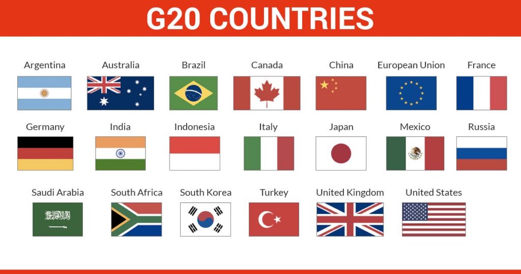
![[Sansad TV] Perspective: Cluster Farming](https://d18x2uyjeekruj.cloudfront.net/wp-content/uploads/2022/12/sansad.jpg)