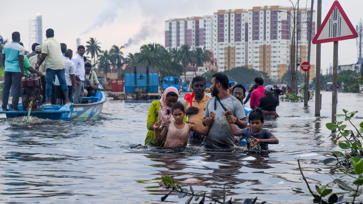
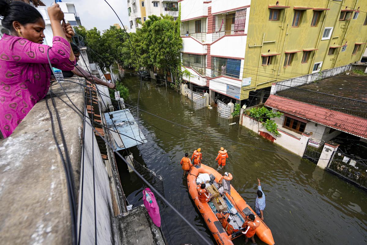
💥Join UPSC 2027,2028 Mentorship (July Batch) + XFactor Notes & Microthemes PDF

GS Paper: GS3-19.Disaster and Disaster Management.

  • Opportune moment to rediscover Chennai’s hydrology

    Opportune moment to rediscover Chennai's hydrology - The Hindu

    Central idea 

    The article underscores the recurring floods in Chennai, attributing them to climate change while questioning the extent to which historical human errors and negligence contribute. Emphasizing the need for comprehensive measures, it calls for hydrological mapping, restoration of neglected water bodies, and ecological conservation to achieve flood resilience and sustainable water supply.

    Key Highlights:

    • Climate Change Attribution: Frequent floods in Chennai, attributed to climate change, raise questions about the impact of historical human errors and the effectiveness of conventional wisdom in flood mitigation.
    • Devastating Impact: Neglected irrigation tanks, encroachment on water bodies, and inadequate watershed management contribute to devastating floods, with the 2023 flood considered the worst in 47 years.
    • Need for Comprehensive Measures: The need for comprehensive hydro-elevation mapping, restoration of water bodies, and protection of ecological hotspots is emphasized for flood resilience and sustainable water supply.

    Key Challenges:

    • Historical Neglect: Neglected irrigation tanks and encroachment on water bodies contribute to over 80% runoff, worsening flood impacts.
    • Urban Expansion: Rapid urban expansion in Chennai, without considering ecological hotspots, leads to the loss of water bodies and wetlands.
    • Inadequate Maintenance: Major waterways and drainage systems suffer from heavy encroachments, sludge deposits, and lack of year-long maintenance.

    Key Terms:

    • Hydro-elevation Mapping: Mapping of upstream-downstream watersheds to understand water dynamics and drainage systems.
    • Ecological Hotspots: Areas with high biodiversity and ecological importance, crucial for flood resilience.
    • Storm Water Drain Network: A 2,900-kilometer network designed to manage stormwater runoff in the Greater Chennai Corporation (GCC) area.

    Key Phrases:

    • “Decode Chennai’s urban and peri-urban hydrology”: Emphasizes the need to understand and intervene in the interconnected hydrological conditions of Chennai.
    • “Converting disaster into opportunity”: Encourages turning flood challenges into an opportunity for sustainable water supply.

    Key Quotes:

    • “Are we hiding behind climate change for all the blunders made so far?”: Questions the tendency to attribute all flood-related issues to climate change.
    • “Have we learned any lessons from past flood events?”: Raises concerns about the lack of corrective measures despite repeated floods.

    Key Examples and References:

    • Chennai’s 3,588 irrigation tanks neglected, contributing to high runoff and flood damage.
    • Loss of water bodies and Pallikaranai marsh land due to rapid urban expansion.
    • The 2023 flood considered the worst in 47 years, highlighting the escalating impact of floods.

    Key Statements:

    • “Chennai city and the CMA can be permanently saved from floods”: Encourages a proactive approach to flood resilience through scientific interventions and ecological protection.
    • “Hiding behind climate change for all accumulated blunders”: Challenges the attribution of all flood-related issues to climate change without addressing historical neglect and errors.

    Key Facts:

    • The CMA to be expanded from 1,189 sq.km to 5,904 sq.km as part of Master Plan III, necessitating protection of ecological hotspots.
    • Rapid urban expansion in Chennai cited as one of the fastest in the country.

    Key Data:

    • 4,000 water bodies in the proposed CMA area, requiring protection from encroachments.

    Critical Analysis:

    • Challenges the effectiveness of conventional approaches and calls for a shift towards scientific and meaningful interventions in water management.
    • Emphasizes the need for a balance between urban expansion and ecological conservation for sustainable flood resilience.

    Way Forward:

    • Comprehensive Mapping: Conduct hydro-elevation mapping to understand water dynamics and drainage systems.
    • Restoration and Protection: Restore water bodies to original or increased capacity, protect ecological hotspots, and enforce “no development zones.”
    • Sustainable Urban Planning: Integrate ecological considerations into urban planning to prevent irreversible damage from urban expansion.
  • How we are rescuing workers trapped in Uttarkashi tunnel

    Uttarakhand tunnel collapse LIVE: Pipeline laid inside to rescue 41 trapped  workers | Hindustan Times

    Central idea

    The central idea focuses on the Silkyara Tunnel rescue in Uttarakhand, highlighting diverse worker representation and challenges in Himalayan geology. The strategic use of auger and drift technology plays a crucial role in the efficient rescue operation. The primary goal is the safe return of 41 trapped workers through a unified and adaptive approach.

    Key Highlights:

    • Silkyara Tunnel incident in Uttarkashi, Uttarakhand, sparks a coordinated effort by government and private agencies.
    • 41 workers trapped in a partially collapsed tunnel, representing a diverse group from different states.
    • Technological advancements, communication, and transportation are leveraged for the rescue operation.
    • Involvement of multiple government bodies, including the Prime Minister’s Office and various ministries.

    Key Challenges:

    • Risks and challenges associated with the rescue operation, including the unpredictable nature of Himalayan geology.
    • The need to balance urgency with caution in the rescue efforts.
    • Varying degrees of difficulty in deploying machinery due to the risk factor and geological complexities.

    Key Terms and Phrases for value addition:

    • Silkyara Tunnel
    • “All of government” approach
    • Himalayan geology
    • Simultaneity principle
    • Auger technology
    • Drift technology
    • Convergence of capability

    Auger Technology:

    • Definition: Auger technology involves the use of a rotating metal shaft with a blade at the end.
    • Application in Rescue: In the Silkyara Tunnel rescue, auger technology is deployed to scrape or cut debris and earth, creating a path for rescuers.
    • Success: A portion of 22 meters has been successfully negotiated, demonstrating the effectiveness of auger technology.
    • Challenges: Geological impediments have posed challenges, requiring restarting the effort.

    Drift Technology:

    • Definition: Drift technology involves scraping the sides of the tunnel to increase its size and create access.
    • Application in Rescue: Used to widen the tunnel for easier access and maneuverability in the rescue operation.
    • Timing: Top and side boring attacks on the tunnel alignment will commence in due course.
    • Redundancy: Provides a redundant approach to ensure the success of the rescue operation.

    Key Facts and Data:

    • 41 workers trapped inside a partially collapsed tunnel.
    • Efforts initiated by the Prime Minister’s Office, Ministry of Road Transport and Highways, Ministry of Home Affairs, NDMA, and Uttarakhand SDMA.
    • Five rescue approaches with time frames ranging from five-six days to eight weeks.

    Critical Analysis:

    • Emphasis on the coordinated efforts involving various government bodies and private sectors.
    • Recognition of the unpredictable nature of Himalayan geology and the associated challenges.
    • Utilization of advanced technologies such as auger and drift technology to address the complexities.
    • Highlighting the psychological and social impacts on workers and the provision of psycho-social specialists.
    • Acknowledgment of the importance of enabling convergence of capability among competent agencies.

    Way Forward:

    • Continued focus on simultaneous approaches to expedite the rescue operation.
    • Prioritizing the horizontal approach using auger technology and drift technology.
    • Recognition of leadership from New Delhi as a crucial factor in ensuring effective coordination.
    • Emphasizing the importance of the safe return of the trapped workers as the primary goal.
  • Steering road safety in India back onto the right lane

    Maharashtra Records A Dip In Road Accidents In Last Three Years

    Central idea

    India’s road safety crisis, witnessing an estimated 300,000 annual fatalities, demands immediate interventions. Despite economic progress, road crashes cost 5-7% of the national GDP, emphasizing the need for strategic investments, political will, and a collective mindset shift. Urgent actions are crucial to curb this silent but deadly pandemic.

    Key Highlights:

    • India’s Annual Road Fatalities: Approximately 3,00,000 people lose their lives on Indian roads annually.
    • Global Road Deaths: India contributes to 25% of the worldwide road fatalities.
    • India’s Disproportionate Role: Despite global road safety concerns, one in four road deaths occurs in India.
    • Economic Toll: Road crashes in India impose a substantial economic cost, ranging from 5-7% of the nation’s GDP.

    Challenges:

    • Urgent Intervention Needed: Over 34 deaths per hour underscore the critical need for immediate and coordinated action.
    • Economic Impact: The economic toll of road crashes in India is substantial, affecting the nation’s GDP.
    • Economic Toll: Road crashes in India impose a substantial economic cost, ranging from 5-7% of the nation’s GDP.
    • State Disparities: The economic impact varies across states, impacting the quality of emergency care and after-care services.

    Key Data:

    • Annual Road Fatalities: Approximately 3,00,000 people are estimated to be killed on Indian roads every year. Equivalent to more than 34 people every hour of every day.
    • Economic Toll: Road crashes in India are estimated to cost between 5% and 7% of the national GDP.
    • Global Road Safety: Positions road safety as a global problem, with 1.3 million people killed in road crashes every year.

    Key Phrases:

    • Silent Pandemic: Describes road-related fatalities as a silent but deadly pandemic demanding attention.
    • Whole-of-Society Effort: Emphasizes the need for a collaborative approach involving government, private sector, and citizens.
    • World Day of Remembrance: Commemorates the World Day of Remembrance for Road Traffic Victims on November 19.
    • Motor Vehicles (Amendment) Act, 2019: Indicates positive steps taken by the Indian government to enhance road safety measures.

    Analysis:

    • Pedestrians and Two-Wheelers: Emphasizes the vulnerability of pedestrians, cyclists, and two-wheeler riders, constituting 75% of road deaths in India.
    • Policy Impact: Acknowledges positive steps like the Motor Vehicles (Amendment) Act, 2019, and improved data collection while emphasizing the need for a comprehensive safe-system approach.
    • Legislative Impact: Acknowledges positive steps like the Motor Vehicles (Amendment) Act, 2019, and emphasizes the need for strategic investments in road safety measures.
    • Data-Driven Approach: Highlights the importance of enhanced data collection to understand the causes and locations of road crashes better.

    Way Forward:

    • Seatbelt and Helmet Use: Prioritize the enforcement of seatbelt and helmet use for both drivers and passengers to significantly reduce fatalities.
    • Behavioral Change: Emphasize the importance of public awareness campaigns like #MakeASafetyStatement to instigate behavioral changes and promote road safety.
    • Large-Scale Initiatives: Launch campaigns on a national scale, such as #MakeASafetyStatement, involving international celebrities, to raise awareness and instigate behavioral changes.
    • Collaborative Efforts: Encourage a whole-of-society effort involving the government, private sector, and citizens for effective road safety measures.
  • Dam Safety Act 2021

    hydel dam safety

    Central Idea

    • India boasts nearly 6,000 large dams, but concerns loom over the safety of these structures, with approximately 80% of them being over 25 years old and posing safety risks.
    • With numerous large dams and hydropower projects, the Himalayas play a crucial role in meeting India’s energy needs.
    • However, the recent incident of a Glacial Lake Outburst Flood (GLOF) in North Sikkim has raised alarm bells about the safety of these structures.

    Hydropower boom in the Himalayas

    • As of November 2022, the Himalayan states and Union territories, excluding West Bengal, had 81 large hydropower projects (above 25 MW) in operation, with 26 more under construction.
    • An additional 320 large projects are in the planning stages, according to the Central Electricity Authority under the Union Ministry of Power.

    Discussion: Dam Safety in the Himalayas

    • Vulnerability to Natural Hazards: The Himalayas are highly susceptible to natural hazards such as earthquakes, landslides, and GLOFs due to their complex geological and topographical features. These hazards can jeopardize the integrity of dams and reservoirs.
    • High Population Density: The Himalayan region is densely populated, with communities residing downstream of dams and hydropower projects. A dam failure can have devastating consequences on human lives and property.
    • Ecological Sensitivity: The Himalayas are an ecologically fragile region with unique biodiversity. A dam failure can lead to environmental disasters, impacting delicate ecosystems.

    Repercussions

    • Climate Change: The melting of glaciers due to global warming contributes to the formation of glacial lakes. As these lakes grow, the risk of GLOFs increases, putting downstream infrastructure at risk.
    • Snowball Effects: Landslide dams can lead to impounding of lakes, landslide-induced floods, secondary landslides, channel avulsion, and the formation of flood terraces downstream, impacting communities and infrastructure.
    • Delayed Impacts: Run-of-the-river projects, which often bypass large-scale displacement and forest diversion, have been promoted as environmentally friendly. However, their underground components can disturb geology and geohydrology, leading to indirect displacement and environmental impacts.
    • Aging Infrastructure: Many dams and hydropower projects in the Himalayas are aging, with approximately 80% of them over 25 years old. Proper maintenance and monitoring are essential to ensure their safety.

    Dam Safety Act, 2021 and its Provisions

    • The DSA was introduced in response to dam failures caused by deficient surveillance and maintenance.
    • It establishes key responsibilities and requires the formation of national and state-level bodies for its implementation.
    • The Act outlines the following provisions:
    1. National Committee on Dam Safety: Responsible for overseeing dam safety policies and regulations.
    2. National Dam Safety Authority: Tasked with implementing and resolving state-level disputes.
    3. Chairman of the Central Water Commission (CWC): Heads dam safety protocols at the national level.
    4. State Committee on Dam Safety (SCDS) and State Dam Safety Organisation (SDSO): To be established at the state level.

    Challenges in DSA Implementation

    • Inadequate Risk Assessment: Experts argue that the DSA does not encourage risk-based decision-making and lacks transparency incentives.
    • Transparency Concerns: Dam safety should be a public function, with information readily accessible. However, transparency is impeded when government employees and project engineers dominate national and state bodies, potentially compromising objective decision-making.

    Lessons Learned from Recent Incidents

    • Comprehensive Risk Assessment: Dam safety protocols must include comprehensive risk assessments that consider factors such as climate change, geological stability, and the potential for GLOFs. Periodic reviews yield updated inundation maps and rule curves for reservoir capacity.
    • Hazard Profiling Issues: Hazard risk is influenced by climate change, urbanization, and water usage patterns. Periodic reviews should yield updated inundation maps and rule curves for reservoir capacity. Unfortunately, these reviews are often overlooked or findings are not made publicly available.
    • Standardized Safety Evaluation: The DSA mandates comprehensive dam safety evaluations but lacks standardization in how failures are analyzed and reported.
    • Transparent Reporting: Transparency in dam safety is paramount. The DSA should be implemented rigorously, with an emphasis on transparent reporting of dam failures and safety assessments.
    • Community Involvement: Local communities should be actively engaged in dam safety measures. They can provide valuable insights into the environmental and social impacts of such projects.

    Way Forward

    • Early Warning Systems: Establishing advanced early warning systems that can detect GLOFs and other potential hazards is crucial. These systems can save lives and minimize damage.
    • Regular Maintenance: Aging infrastructure must undergo regular maintenance and upgrades to ensure their continued safety and functionality.
    • International Collaboration: Given the transboundary nature of the Himalayan region, international collaboration on dam safety and disaster management is essential. Neighboring countries should work together to mitigate shared risks.
  • Glacial Lake Outburst Flood in Sikkim

    What’s the news?

    • On October 4th, in a tragic turn of events, Sikkim witnessed a devastating incident where the South Lhonak Lake ruptured due to incessant rainfall, resulting in the loss of fourteen lives and the disappearance of 102 individuals, including 23 Army personnel.

    Central idea

    • Sikkim, nestled in the Himalayas, faces the aftermath of a catastrophic Glacial Lake Outburst Flood (GLOF) triggered by incessant rainfall. The South Lhonak Lake, perched at 17,000 feet in the state’s northwest, burst, inundating four districts—Mangan, Gangtok, Pakyong, and Namchi.

    What are glacial lakes?

    • Glacial lakes are large bodies of water that are typically located in proximity to, on top of, or beneath glaciers.
    • These lakes are primarily formed as a result of glacial processes, such as the melting of ice and the accumulation of meltwater in depressions or basins created by the glacier’s movement.

    Concept: Glacial Lake Outburst Floods (GLOF)

    • A Glacial Lake Outburst Flood (GLOF) is a sudden and often catastrophic release of water from a glacial lake, typically caused by the breach or failure of the natural dams that contain the lake.
    • GLOFs occur in regions with glaciers, where meltwater accumulates in depressions or basins created by the glacier’s movement.
    • These floods can have severe and far-reaching consequences for downstream communities and environments.

    Causes: GLOFs can be triggered by various factors

    • Melting Glaciers: Rapid glacier melt due to rising temperatures can increase the volume of water in glacial lakes.
    • Avalanches: Snow or ice avalanches can impact the lake, dislodging ice and debris into the water.
    • Earthquakes: Seismic activity can destabilize the natural dams or trigger avalanches.
    • Rainfall: Heavy rainfall can contribute additional water to the lake and weaken natural dams.
    • Volcanic Eruptions: Volcanic activity can lead to the rapid melting of glaciers and the formation of glacial lakes.

    Destruction and Impact

    • Flooding: Downstream areas can experience rapid and extensive flooding, with water levels rising quickly.
    • Destruction of Infrastructure: GLOFs can damage or destroy roads, bridges, buildings, and farmland.
    • Loss of Life: GLOFs often result in the loss of human lives as well as harm to livestock and wildlife.
    • Environmental Damage: The floodwaters and debris can severely impact the natural environment, including forests, wetlands, and river ecosystems.

    Notable GLOF events

    • Some GLOF events in the past have resulted in significant loss of life and damage to infrastructure.
    • The horrifying 2013 flash floods in Uttarakhand’s Kedarnath serve as a stark reminder of the devastating consequences of GLOFs.
    • This calamity was compounded by a GLOF event originating from the Chorabari Tal glacial lake, leading to the loss of thousands of lives.

    The Sikkim Calamity: South Lhonak Lake’s Susceptibility to GLOF

    • Glacial Melting: Rising global temperatures have accelerated the melting of glaciers in the Sikkim Himalayas, including the glacier feeding South Lhonak Lake. This increased meltwater contributes to the lake’s water volume, making it more susceptible to GLOFs.
    • Glacial Lake Expansion: The South Lhonak Lake’s area has significantly increased over the past five decades. It has grown nearly 1.5 times, while its neighbor, North Lhonak, has expanded nearly 2.5 times its initial size in 1989. This expansion is a direct result of glacier retreat and melt, exacerbating the lake’s vulnerability.
    • Seismic Activity: The region around South Lhonak Lake is prone to seismic activity. Earthquakes can destabilize the natural dams or trigger avalanches, which can lead to a sudden release of water from the lake, potentially causing a GLOF event.
    • Past Earthquakes: Seismic events occurred in the region, such as an earthquake of magnitude 4.9 in 1991 near the parent glacier feeding South Lhonak Lake and another earthquake of magnitude 6.9 in 2011, approximately 70 km from the lakes. These past earthquakes and the potential for future seismic activity increase the risk of GLOFs in the area.

    Government interventions

    • Syphoning Off Lake Water: In 2016, the Sikkim government, in collaboration with various agencies including the Sikkim State Disaster Management Authority and Sikkim’s Department of Science and Technology and Climate Change, took proactive measures to mitigate the risk associated with South Lhonak Lake. They decided to syphon off water from the lake.
    • Innovative Approach: The technique employed for syphoning off lake water was innovative and effective. Under the supervision of innovator Sonam Wangchuk, authorities installed three eight-inch-wide and 130-140-meter-long High-Density Polyethylene (HDPE) pipes in the lake. These pipes were used to extract water from the lake.
    • Water Extraction Rate: The initiative successfully extracted 150 liters of water per second from South Lhonak Lake, which was a substantial volume. This action aimed to reduce the water level in the lake, thus mitigating the risk of a potential GLOF.

    Way forward: Warning and Mitigation

    • Lake Monitoring: Regular monitoring of glacial lakes to assess changes in water levels and the stability of natural dams
    • Early Warning Systems: Implementing systems to detect and warn downstream communities of potential GLOFs
    • Infrastructure: constructing protective infrastructure, such as dams or diversion channels, to manage floodwaters
    • Land-Use Planning: Implementing land-use planning and zoning to restrict construction in high-risk areas

    Conclusion

    • The recent calamity in Sikkim underscores the imminent threat of GLOFs in the Himalayan region. While government initiatives are commendable, continued monitoring, research, and disaster preparedness are vital to safeguarding vulnerable communities in the face of the expanding glacial lakes and the looming specter of GLOFs.
  • Protecting floodplains is the need of the hour

    What’s the news?

    • Indian cities are projected to contribute significantly to the country’s GDP by 2030. Flooding in these urban centers has a substantial economic impact, underscoring the importance of effective flood management.

    Central idea

    • The world is grappling with a dual challenge of water scarcity and excess as climate change intensifies. The frequency and intensity of floods are on the rise, with devastating consequences. The urgency of addressing this issue cannot be overstated.

    Recent catastrophic floods

    • Last year, Pakistan witnessed catastrophic floods that claimed lives and affected millions.
    • India has faced its share of calamities, such as the 2013 Uttarakhand floods, the 2014 Kashmir Valley deluge, the 2015 Chennai floods, and the 2017 Gujarat floods.
    • This year, Himachal Pradesh experienced rain-induced floods and landslides.

    Why is India prone to flooding?

    • Geographical Vulnerability: The article mentions that over 40 million hectares, which is nearly 12% of India’s total land area, are prone to floods, as indicated by the Geological Survey of India. This vulnerability is due to India’s diverse geography, including extensive river systems, coastal regions, and mountainous areas.
    • Climate Change: Floods are increasing in frequency and intensity, and this trend is expected to continue due to climate change. Extreme precipitation events are becoming more common, contributing to flooding.
    • Urbanization Challenges: Rapid and haphazard urbanization is one of the factors that makes Indian cities vulnerable to floods. The expansion of cities, often without proper consideration of natural topography, increases the risk of flooding in urban areas.
    • Inadequate Legal Framework: India primarily relies on the Disaster Management Act of 2005 for flood management, but this law is not specifically focused on flood risk management and assumes that disasters cannot be predicted, which may not be entirely accurate for floods.
    • Large-Scale Encroachments: India faces challenges due to extensive encroachments on floodplains, including illegal construction and mining activities. These encroachments reduce the natural capacity of rivers and floodplains to handle excess water during heavy rainfall.
    • Chennai Floods Example: The 2015 Chennai floods were attributed to these encroachments, and the Comptroller and Auditor General of India labeled it a man-made disaster.
    • Weak Enforcement of Environmental Laws: The environmental protection laws in India are often not effectively implemented. Central policies related to floodplain protection lack binding power over states, allowing encroachments to persist.

    Flood Plains and their Significance

    • Flood plains adjacent to rivers serve as natural defences against inland flooding. Maintained without concrete encroachments, they absorb excess water, safeguarding other regions.
    • Properly managed flood plains also aid in recharging groundwater levels and maintaining the water table.

    Key issues related to occupying floodplains and the challenges it poses in India

    • Reduced River Capacity: Illegal construction in floodplains diminishes the natural capacity of rivers to contain high water levels within their banks. This becomes especially problematic during periods of heavy rainfall when water from upper catchment areas flows downstream.
    • Neglect of Eco-Sensitive Areas: In Uttarakhand, there has been a disregard for eco-sensitive floodplains with the construction of guest houses and hotels along riverfronts to promote tourism and economic growth. This neglect has contributed to increased flood risks.
    • Regulatory Efforts: Following the massive floods in 2013, the National Green Tribunal issued a directive in 2015, essentially barring construction within 200 meters of the Ganga’s banks. However, attempts to bypass this directive have been made, raising questions about the proper implementation of environmental impact assessments.
    • Ineffective Legislation: The Uttaranchal River Valley (Development and Management) Act of 2005 was established to regulate mining and construction in river valleys. However, reports suggest rampant mining and construction activities with little consideration for environmental protection.
    • Weak Implementation of Environmental Laws: Despite having environmental protection laws in place, India faces issues with their implementation. Central policy measures to protect floodplains are often non-binding on states, and there is a lack of effective enforcement.

    Strategies to preserve ecosystems

    • International Examples:
    • Examples from around the world include Germany’s Federal Water Act, which underwent a significant change in 1996 following a massive flood.
    • The law now prioritizes the protection of the original retention capacity of water bodies during reconstruction.
    • This change reflects the value of preserving floodplains and enhancing water retention as effective measures against flooding.
    • Cross-Sectoral Approach:
    • Climate change adaptation is described as a cross-sectoral issue that involves various areas of legislation, including land use, water body preservation, coastal regulations, and environmental impact assessment.
    • A comprehensive and integrated approach is necessary to address the complexities of climate change adaptation effectively.
    • Coherent Legal Framework:
    • To tackle climate change and its associated risks, it is crucial to integrate multiple laws into a coherent framework.
    • Passing climate-related legislation alone may not be sufficient if other laws related to land use and environmental protection are not aligned with climate goals.
    • Political Will:
    • Strong political will is identified as a critical factor in achieving effective climate change adaptation strategies.
    • Populist leaders may be hesitant to implement green policies, so there is a need for a shift in political priorities to prioritize environmental protection and climate resilience.

    Conclusion

    • India’s approach to flood management must evolve to embrace integrated flood risk management, learning from global examples. By prioritizing ecosystem preservation and adopting a holistic approach to climate change adaptation, India can better safeguard lives, livelihoods, and infrastructure from the growing threat of floods.

    Also read:

    Why Zoning of Flood Plains is important?


  • Assistance to States during Natural Disasters: How It Works

    Central Idea

    • In the wake of natural disasters, states often request assistance from the central government.
    • Himachal Pradesh CM recently requested for a special disaster relief package and urged the designation of the calamity as a ‘national disaster.’

    Natural Disaster Mitigation in States

    • Legal Framework: The 2005 Disaster Management Act provides the legal framework for addressing disasters, whether natural or man-made.
    • Defining disaster: It defines a “disaster” as an event causing substantial loss of life, human suffering, property damage, or environmental degradation beyond the community’s coping capacity.
    • National Disaster Management Authority (NDMA): The Act established the NDMA, headed by the Prime Minister, and State Disaster Management Authorities (SDMAs) led by Chief Ministers. These bodies, along with district-level authorities, form an integrated disaster management setup in India.
    • National Disaster Response Force (NDRF): The Act led to the creation of the NDRF, comprising several battalions or teams responsible for on-ground relief and rescue operations in various states.

    Understanding the National Disaster Relief Fund (NDRF)

    • Mention in the Act: The NDRF is referenced in the 2005 Disaster Management Act and plays a crucial role in providing disaster relief.
    • State Disaster Relief Funds (SDRFs): States have their own SDRFs, which are the primary funds available for responding to notified disasters. The Central Government contributes 75% to SDRFs in general states and 90% in northeastern and Himalayan states.
    • Utilization of SDRFs: SDRFs are allocated for immediate relief efforts following notified calamities, including cyclones, droughts, earthquakes, fires, floods, tsunamis, and more.
    • Central Assistance: In the event of a severe calamity where state SDRF funds are insufficient, additional central assistance can be provided by the National Disaster Response Fund (NDRF).

    Who determines a Severe Calamity?

    • Procedure: States follow a specific procedure to classify a calamity as “severe.” This involves submitting a memorandum detailing sector-wise damage and fund requirements. An inter-ministerial central team assesses the damage on-site.
    • Committee Approval: Specific committees review these assessments and submit reports. A High-Level Committee must approve the immediate relief amount to be released from the NDRF.
    • Criteria: The classification of a calamity as “severe” considers factors such as intensity, magnitude, assistance needs, and more.

    Additional Funds for Disaster Mitigation

    • Funds Allocation: Funds for NDRF and SDRFs, allocated for preparedness, mitigation, and reconstruction, are part of budgetary allocations.
    • Financing mechanism: The 15th Finance Commission introduced a new methodology for state-wise allocations, considering factors like past expenditure, risk exposure, hazard, and vulnerability.
    • Utilization: NDRF and SDRF funds are released in two equal instalments, typically with requirements like Utilization Certificates. However, in urgent situations, these requirements can be waived.
    • State Disaster Mitigation Fund (SDMF): This fund supports activities such as forest restoration and public awareness. It received an allocation of Rs 32,030 crore from the 15th Finance Commission.
    • National Disaster Mitigation Fund (NDMF): The NDMF, amounting to Rs 13,693 crore, is dedicated to national disaster mitigation efforts.
  • Why Zoning of Flood Plains is important?

    flood plain

    Central Idea

    • Punjab has been grappling with severe floods for over a month, predominantly affecting villages along rivers like Sutlej, Beas, Ravi, and Ghaggar.
    • These areas, known for their fertile flood plains, have been hit the hardest due to floods exacerbated by encroachments and construction.

    Flood Plains and their Significance

    • Flood plains adjacent to rivers serve as natural defences against inland flooding. Maintained without concrete encroachments, they absorb excess water, safeguarding other regions.
    • Properly managed flood plains also aid in recharging groundwater levels and maintaining the water table.

    What is Zoning of Flood Plains?

    • Zoning of flood plains refers to the practice of categorizing and regulating different areas within flood-prone regions based on their vulnerability to flooding and the intensity of flood events.
    • This aims to manage land use and construction activities in these areas to minimize the risks associated with flooding, protect communities and infrastructure, and maintain the natural functions of flood plains.
    • It involves designating specific zones within flood-prone regions and establishing regulations and guidelines for development, construction, and land use in each zone.

    Current Scenario: No Zoning in Punjab

    • National Green Tribunal (NGT): NGT guidelines state that construction should not occur within 500 meters of a river’s central lining.
    • Punjab’s Lag: Despite NGT’s directives and the need for floodplain zoning, Punjab has yet to initiate the process. Encroachments persist, putting riverside villages at perpetual risk.

    Impact of Inaction: People and Ecosystems Affected

    • Risk to People and Property: Unregulated construction leads to increased flood risks further inland, causing greater harm during floods.
    • Environmental Impact: Concretization of flood plains delays water drainage and affects soil fertility and quality.

    Flood Prone Districts and National Issue

    • Districts at Risk: Many districts including Ropar, Ludhiana, Ferozepur, Patiala, and more fall within flood plains, magnifying the need for preparedness.
    • Nationwide Challenge: While only four states have adopted flood plain zoning in principle, implementation has been insufficient. Even those that adopted zoning have not effectively delineated and demarcated flood plains.

    Activists’ Advocacy

    • Activists’ Concerns: Environmental activists and NGOs in Punjab have been advocating for flood plain zoning to mitigate risks.
    • Urgent Implementation: Immediate initiation and completion of flood plain zoning are crucial to safeguard lives, property, and ecosystems from devastating floods.

    Conclusion

    • The recent floods in Punjab underline the urgency of flood plain zoning to avert catastrophe.
    • By adopting effective zoning measures, the state can shield its citizens and environment from the damaging impacts of unchecked construction and flooding.
    • It is imperative that Punjab takes swift action to implement flood plain zoning and thereby protect its vulnerable regions from the perpetual threat of floods.
  • In news: International Atomic Energy Agency (IAEA)

    Central Idea

    • Japan has begun discharging treated radioactive wastewater from the disabled Fukushima Daiichi Nuclear Power Station into the Pacific Ocean in a plan endorsed by the International Atomic Energy Agency (IAEA).

    International Atomic Energy Agency (IAEA)

    • IAEA is an international organization that plays a pivotal role in promoting the peaceful use of nuclear energy while preventing the proliferation of nuclear weapons.
    • It was established in 1957 as an autonomous agency under the UN is headquartered in Vienna, Austria.
    • It plays a crucial role in safeguarding the principles outlined in the Nuclear Non-Proliferation Treaty (NPT) of 1970.
    • Despite its independent treaty, the IAEA remains accountable to both the UN General Assembly and the United Nations Security Council (UNSC).

    What does it do?

    • Promotion of Peaceful Nuclear Energy: Established amidst the Cold War’s geopolitical tension, the IAEA’s core mission centers on promoting the constructive application of nuclear energy.
    • Prevention of Military Use: The agency’s fundamental role is to prevent the diversion of nuclear programs for military intentions, ensuring compliance with international agreements.

    IAEA’s Tri-fold Missions

    • Peaceful Utilization: Fostering member states’ constructive adoption of nuclear energy for peaceful purposes constitutes a pivotal aspect of IAEA’s mission.
    • Safeguarding Measures: A cornerstone role of the IAEA involves implementing measures to verify the non-military use of nuclear energy, particularly through assessing declared nuclear activities and materials.
    • Nuclear Safety: The IAEA takes an active stance in advocating stringent standards of nuclear safety to prevent accidents and ensure public and environmental protection.

    Significant feature: IAEA’s Safeguards

    • Purpose of Safeguards: IAEA’s safeguards are mechanisms designed to affirm that a nation adheres to its international commitment against exploiting nuclear programs for weaponry purposes.
    • Verification Approach: Safeguards are founded on the meticulous examination of a state’s reported nuclear materials and activities, evaluating their accuracy and completeness.
    • Varied Verification Measures: The agency employs a range of verification tools, including on-site inspections, visits, and ongoing monitoring, ensuring rigorous oversight.

    Dual Dimensions of Safeguards

    • Declared Nuclear Material Verification: Through the inspection of reported nuclear materials and activities, IAEA ensures that a state remains transparent in its nuclear endeavors.
    • Non-Diversion Assurance: A significant facet is the assurance of the absence of undeclared nuclear materials or activities, thereby averting any unauthorized deviation from peaceful usage.
  • Himachal Floods: A man-made disaster?

    himachal

    Central Idea

    • Himachal Pradesh has experienced devastating flash floods during the recent monsoon season, resulting in a significant loss of lives and assets.
    • This article explores the factors contributing to the floods, including climate change and anthropogenic actions, and raises questions about the current development model’s sustainability.

    Reasons for amplified Flood Impacts

    [A] Climate Change and Floods

    • IPCC’s Warning: The IPCC VI report predicts that the Himalayas and coastal regions of India will be the hardest hit by climate change. Increased precipitation in shorter periods is evident in the Himalayas, leading to heavy rains and floods.
    • Abnormal Rainfall: Normal rainfall is expected to be between 720mm and 750mm, but instances of exceeding 888mm in 2010 and 926.9mm in 2018 have been observed. The current precipitation has been a result of the combined effect of the southwest monsoon and western disturbances.

    [B] Impact of Development Model

    • Dr. Parmar Model: Himachal Pradesh’s development model, initiated in 1971, transformed the state into a model of development for mountain regions. It focused on land reforms, social welfare investments, and human resource development.
    • Shift in Development: Liberalization brought demands for fiscal reforms, forcing the state to generate its own resources. Exploitation of natural resources such as forests, water, tourism, and cement production became the focus of development efforts.
    • Hydropower Projects: Dominant focus on hydropower projects led to uncontrolled construction, transforming mountain rivers into streams, and causing ecological damage.
    • Tourism Expansion: Road expansion for tourism promotion resulted in bypassing geological studies, leading to landslides and destruction during rainfall.
    • Cement Plants: Establishment of massive cement plants altered the landscape, reducing the land’s water absorption capacity and contributing to flash floods.
    • Changing Crop Patterns: Shift from traditional cereal farming to cash crops increased the demand for hastily constructed roads without proper drainage, leading to rapid swelling of rivers during rainfall.

    Way Forward

    • Commission of Inquiry: Instituting a Commission of Inquiry involving major stakeholders can address policy framework failures and project aspects.
    • Empowering Local Communities: A new architecture is needed to empower local communities over their assets. Insuring assets and involving local communities as custodians can expedite rebuilding efforts.
    • Sustainable Infrastructure: With climate change as a reality, infrastructure planning should adapt to avert disasters and mitigate the impacts of heavy rainfall.

    Conclusion

    • The flash floods in Himachal Pradesh demonstrate the consequences of both climate change and human-induced development.
    • It calls for a comprehensive approach that considers sustainable development practices, empowers local communities, and prioritizes environmental conservation to protect lives and assets in the region.