💥Mains Ready By December. Smash Mains & Smash PYQ Admissions Open

GS Paper: GS3-19.Disaster and Disaster Management.

  • Issues in India’s Cyclone Management

    Context

    The severe cyclones, Tauktae and Yaas, battered India earlier this year. With a rise in the frequency of devastating cyclones, India needs to look at long-term mitigation measures.

    India’s vulnerability

    • The Indian coastline is around 7,500 km; there are 96 coastal districts (which touch the coast or are close to it), with 262 million people exposed to cyclones and tsunamis.
    • The World Bank and the United Nations (2010) estimate that around 200 million city residents would be exposed to storms and earthquakes by 2050 in India.
    • Between 1891 and 2020, out of the 313 cyclones crossing India’s eastern and western coasts, the west coast experienced 31 cyclones, while 282 cyclones crossed the east coast.
    • Among the natural disasters, cyclones constituted the second most frequent phenomena that occurred in 15% of India’s total natural disasters over 1999-2020.
    • According to the Global Climate Risk Index report 2021, India ranks the seventh worst-hit country globally in 2019 due to the frequent occurrence of extreme weather-related events.
    • Increase in frequency: According to India Meteorological Department (IMD), 2013 data frequency of cyclones in the coastal States accounting increased by 7%.
    • Factor’s responsible: Increasing sea surface temperatures in the northern Indian Ocean and the geo-climatic conditions in India are the factors responsible for the increase in frequency.

    Economic cost

    • Between 1999 and 2020, cyclones inflicted substantial damage to public and private properties, amounting to an increase in losses from $2,990 million to $14,920 million in the absence of long-term mitigation measures.
    • India lost around 2% of GDP and 15% of total revenue over 1999-2020.
    • Between 1999-2020, around 12,388 people were killed, and the damage was estimated at $32,615 million.
    • Cyclones are the second most expensive in terms of the costs incurred in damage, accounting for 29% of the total disaster-related damages after floods (62%).
    • In addition, they are the third most lethal disaster in India after earthquakes (42%) and floods (33%).

    Odisha model

    • In the aftermath of the 1999 super cyclone, the Government of Odisha took up various cyclone mitigation measures.
    • These included installing a disaster warning system in the coastal districts, and construction of evacuation shelters in cyclone-prone districts.
    • Other steps were the setting up of the Odisha State Disaster Management Authority (OSDMA), conducting regular cabinet meetings for disaster preparedness, and building the Odisha Disaster Rapid Action Force (ODRAF).

    Way forward

    • Still, Odisha’s disaster management model is inadequate to minimise the economic losses that result from cyclones.
    • Therefore, the Government of India should adopt a few measures to minimise disaster damage and fatalities.
    • Improve warning system: It is imperative to improve the cyclone warning system and revamp disaster preparedness measures.
    • Increase cover under shelterbelt plantation: The Government must widen the cover under shelterbelt plantations and help regenerate mangroves in coastal regions to lessen the impact of cyclones.
    • In addition, adopting cost-effective, long-term mitigation measures, including building cyclone-resilient infrastructure such as constructing storm surge-resilient embankments, canals and improving river connectivity to prevent waterlogging in low-lying areas are important.
    • Disaster resilient power infrastructure: installing disaster-resilient power infrastructure in the coastal districts, providing concrete houses to poor and vulnerable households, and creating massive community awareness campaigns are essential.
    • Coordination between Centre-State: Healthy coordination between the Centre and the States concerned is essential to collectively design disaster mitigation measures.
    • Collective mitigation effort by the Centre and States that can help reduce the fiscal burden of States and also be effective in minimising disaster deaths.

    Conclusion

    Long term mitigation measures are essential to minimise the impact of the disasters such as cyclones.

    UPSC 2022 countdown has begun! Get your personal guidance plan now! (Click here)

  • Declaring a National Calamity

    Under the existing Scheme of State Disaster Response Fund / National Response Fund of the Ministry of Home Affairs, there is no provision to declare any disaster including flood as a National Calamity.

    How does the law define a disaster?

    • A natural disaster includes earthquake, flood, landslide, cyclone, tsunami, urban flood, heatwave; a man-made disaster can be nuclear, biological and chemical.
    • As per the Disaster Management Act, 2005, “disaster” means:
    1. A catastrophe, mishap, calamity or grave occurrence in any area, arising from natural or man-made causes, or
    2. It results in substantial loss of life or human suffering or damage to, and destruction of, property, or damage to, or degradation of, environment, and
    3. Damage is of such a nature or magnitude as to be beyond the coping capacity of the community of the affected area.

    How can any of these be classified as a national disaster?

    • There is no provision, executive or legal, to declare a natural calamity as a national calamity.
    • The existing guidelines of the State Disaster Response Fund (SDRF)/ National Disaster Response Fund (NDRF), do not contemplate declaring a disaster as a National Calamity.

    Has there ever been an attempt to define a national calamity?

    • In 2001, the National Committee under the chairmanship of the then PM was mandated to look into the parameters that should define a national calamity.
    • However, the committee did not suggest any fixed criterion.

    How, then, does the government classify disasters/calamities?

    • The 10th Finance Commission (1995-2000) examined a proposal that a disaster be termed “a national calamity of rarest severity” if it affects one-third of the population of a state.
    • The panel did not define a “calamity of rare severity” but stated that a calamity of rare severity would necessarily have to be adjudged on a case-to-case basis taking into account.

    What happens if a calamity is so declared?

    • When a calamity is declared to be of “rare severity/severe nature”, support to the state government is provided at the national level.
    • The Centre also considers additional assistance from the NDRF.
    • A Calamity Relief Fund (CRF) is set up, with the corpus shared 3:1 between Centre and state.
    • When resources in the CRF are inadequate, additional assistance is considered from the National Calamity Contingency Fund (NCCF), funded 100% by the Centre.
    • Relief in repayment of loans or for grant of fresh loans to the persons affected on concessional terms, too, are considered once a calamity is declared “severe”.
  • Why cloudbursts could become more frequent?

    Recently, cloudbursts have been reported from several places in J&K, Ladakh, Uttarakhand and Himachal Pradesh. A

    What is a Cloudburst?

    • Cloudbursts are short-duration, intense rainfall events over a small area.
    • According to the IMD, it is a weather phenomenon with unexpected precipitation exceeding 100mm/h over a geographical region of approximately 20-30 square km.

    What causes Cloudburst?

    • A study published last year studied the meteorological factors behind the cloudburst over the Kedarnath region.
    • They analyzed atmospheric pressure, temperature, rainfall, cloud water content, cloud fraction, cloud particle radius, cloud mixing ratio, total cloud cover, wind speed, wind direction, and relative humidity during the cloudburst, before as well as after the cloudburst.
    • The results showed that during the cloudburst, the relative humidity and cloud cover was at the maximum level with low temperature and slow winds.
    • It is expected that because of this situation a high amount of clouds may get condensed at a very rapid rate and result in a cloudburst.

    Impact of climate change

    • Several studies have shown that climate change will increase the frequency and intensity of cloudbursts in many cities across the globe.
    • As temperatures increase the atmosphere can hold more and more moisture and this moisture comes down as a short very intense rainfall for a short duration.
    • This results in flash floods in the mountainous areas and urban floods in the cities.
    • Also, there is evidence suggesting that globally short duration rainfall extremes are going to become more intense and frequent.

    Answer this PYQ in the comment box:

    Q.During a thunderstorm, the thunder in the skies is produced by the:

    1. meeting of cumulonimbus clouds in the sky
    2. lightning that separates the nimbus clouds
    3. violent upward movement of air and water particles

    Select the correct option using the codes given below:

    (a) 1 only

    (b) 2 and 3 only

    (c) 1 and 3 only

    (d) None of the above

  • Graded Response Action Plan (GRAP)

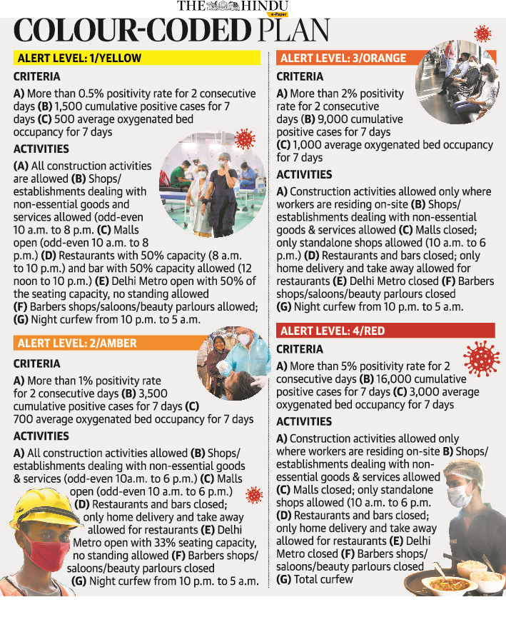
    Fearing any surge in coronavirus cases in the national capital, which is witnessing a decline in cases of infection, the Delhi government has chalked out the ‘Graded Response Action Plan (GRAP).’

    Graded Response Action Plan (GRAP)

    • In 2014, when a study by the WHO found that Delhi was the most polluted city in the world, panic spread in the Centre and the state government.
    • Approved by the Supreme Court in 2016, the plan was formulated after several meetings that the Environment Pollution (Prevention and Control) Authority (EPCA) held with state government and experts.
    • The result was a plan that institutionalized measures to be taken when air quality deteriorates.
    • GRAP also works as an emergency measure.
    • It includes strict measures such as a ban on the entry of heavy vehicles, the odd-even road rationing restrictions, and a halt of construction work – each of which is likely to be impractical at a time when the pandemic has exacted heavy economic costs and public transport has been seen as an infection risk.

    For covid purposes

    • This time, it was decided to notify the GRAP that will “objectively and transparently” ensure an “institutional and automatic” response with regards to enforcement measures, lockdowns and unlock activities.
    • The plan was prepared in comparison with ascent data of the four waves at specific positivity rates of 0.5%, 1%, 2% and 5% and also considered on the basis of the earlier four waves.
  • Compensation for Covid deaths

    The Supreme Court has reserved its verdict seeking compensation of Rs 4 lakh to the kin of those who have died of Covid-19 or related complications.  The Centre has stated that state governments cannot afford to pay this, and had argued in favor of a broader approach including health interventions.

    Provisions for Compensation

    • Last year, the Centre declared Covid-19 as a notified disaster under the Disaster Management Act.
    • Section 12(iii) of the Act says the National Authority shall recommend guidelines for the minimum standards of relief to be provided to persons affected by disaster.
    • It includes “ex gratia assistance on account of loss of life as also assistance on account of damage to houses and for restoration of means of livelihood”.
    • The Centre revises this amount from time to time.

    What is the latest amount?

    • On April 8, 2015, the Disaster Management Division of the Home Ministry wrote to all state governments and attached a revised list of “norms of assistance”.
    • Under “ex gratia payment to families of deceased persons”, it specified: Rs 4 lakh per deceased person including those involved in relief operations or associated in preparedness activities.
    • This is subjected to certification regarding cause of death from appropriate authority.

    So, what about compensation for Covid?

    • Last year the Home Ministry wrote to state governments that the central government has decided to treat it (Covid-19) as a notified disaster for the purpose of providing assistance under SDRF.
    • It attached a partially modified list of items and norms of assistance.
    • It did not specify payment of ex gratia to families of deceased.
    • Some states have decided to pay, but not for all deaths.

    How has the government responded to the petition?

    • The Centre has submitted that ex gratia of Rs 4 lakh is beyond the affordability of state governments.
    • It argued that if Rs 4 lakh is paid to the kin of each, it “may possibly” consume the entire amount of the State Disaster Relief Fund (SDRF).
    • This would leave states with insufficient funds for organizing a response to the pandemic, or to take care of other disasters.
    • The centre argued that the term ex gratia itself means the amount is not based on legal entitlement.

    Way ahead

    • A broader approach, which involves health interventions, social protection, and economic recovery for the affected communities would be a more prudent, responsible, and sustainable approach.
  • [pib] Satellite-based real-time monitoring of Himalayan glacial catchments

    Melting of glaciers in Himalaya and GLOFs

    • The Himalayan region is home to the largest ice mass outside of the planet’s Polar Regions.
    • The glaciers in the Himalayas are melting at a faster rate creating new lakes and expanding the existing ones.
    • The rising temperatures and extreme precipitation events make the region increasingly prone to a variety of natural hazards, including devastating glacial lake outburst floods (GLOFs).
    • GLOFs occur when either a natural dam containing a glacial lake bursts or when the lake’s level suddenly increases and overflows its banks, leading to catastrophic downstream destruction.
    • However, the remote, challenging Himalayan terrain and the overall lack of cellular connectivity throughout the region have made the development of early flood warning systems virtually impossible.
    • In their recent work the Scientists point out that the surge of meltwater in mountain streams is most commonly caused by cloud-burst events during the monsoon season (June–July–August) time frame.

    Satelitte-based real-time monitoring

    • Satellite-based real-time monitoring of Himalayan glacial catchments would improve understanding of flood risk in the region and help inform an early flood warning system that could help curb disaster and save human lives, says a recent study.
    • This should be the future strategy to reduce loss of human lives during glacial lake outburst floods (GLOF), said a study carried out by scientists from IIT Kanpur.
    • The IIT Kanpur team suggests that efforts to help mitigate GLOF events in the future should include the creation of a network of satellite-based monitoring stations that could provide in situ and real-time data on GLOF risk.
    • The integration of monitoring devices with satellite networks will not only provide telemetry support in remote locations that lack complete cellular connectivity but will also provide greater connectivity in coverage in the cellular dead zones in extreme topographies such as valleys, cliffs, and steep slopes.
  • [pib] Coalition for Disaster resilient Infrastructure (CDRI)

    The Prime Minister has recently addressed the third edition of the annual conference of the Coalition for Disaster resilient Infrastructure (CDRI).

    What is CDRI?

    • The CDRI is an international coalition of countries, UN agencies, multilateral development banks, the private sector, and academic institutions that aim to promote disaster-resilient infrastructure.
    • Its objective is to promote research and knowledge sharing in the fields of infrastructure risk management, standards, financing, and recovery mechanisms.
    • It was launched by the Indian PM Narendra Modi at the 2019 UN Climate Action Summit in September 2019.
    • CDRI’s initial focus is on developing disaster-resilience in ecological, social, and economic infrastructure.
    • It aims to achieve substantial changes in member countries’ policy frameworks and future infrastructure investments, along with a major decrease in the economic losses suffered due to disasters.

    Try this PYQ:

    Q.Consider the following statements:

    1. Climate and Clean Air Coalition (CCAC) to Reduce Short Lived Climate Pollutants is a unique initiative of G20 group of countries
    2. The CCAC focuses on methane, black carbon and hydrofluorocarbons.

    Which of the above statements is/are correct?

    (a) 1 only

    (b) 2 only

    (c) Both 1 and 2

    (d) Neither 1 nor 2

    Its inception

    • PM Modi’s experience in dealing with the aftermath of the 2001 Gujarat earthquake” as the chief minister led him to the idea.
    • The CDRI was later conceptualized in the first and second edition of the International Workshop on Disaster Resilient Infrastructure (IWDRI) in 2018-19.
    • It was organized by the National Disaster Management Authority (NDMA), in partnership with the UN Office for Disaster Risk Reduction (UNDRR), the UN Development Programme, the World Bank, and the Global Commission on Adaptation.

    Its diplomatic significance

    • The CDRI is the second major coalition launched by India outside of the UN, the first being the International Solar Alliance.
    • Both of them are seen as India’s attempts to obtain a global leadership role in climate change matters and were termed as part of India’s stronger branding.
    • India can use the CDRI to provide a safer alternative to China’s Belt and Road Initiative (BRI) as well.
  • Cost of development in the fragile mountains

    The article explains the relationship between development activities in Uttarakhand and the devastating floods.

    Cause of recent flash flood in Uttarakhand

    • According to Planet Labs, ice along with frozen mud and rocks fell down from a high mountain inside the Nanda Devi Sanctuary, from a height of 5,600 m to 3,300 m.
    • This created an artificial lake within the sanctuary in Rontigad, a tributary of Rishi Ganga.
    • Within eight hours, this lake burst open and its water, laden with mud and stones, rushed through the Rishi Ganga gorge which opens near Reni.
    • Studies say that the current winter season has seen little rain and snow, with temperatures being highest in the last six decades.
    •  So, the effects of chemical weathering were much more active in the higher Himalayas.
    •  There is a possibility of more such events this year.

    Factors responsible

    1) Development with no regard for the environment

    • As a mountain system, the Himalayas have had earthquakes, avalanches, landslides, soil erosion, forest fires and floods, and these are its natural expressions, parts of its being.
    • Except for earthquakes, humans have directly contributed towards aggravating all the other phenomena.
    • The Ravi Chopra committee formed by the SC recommended closure of all the 24 hydro projects in question by Wildlife Institute of India.
    • The SC also formed another committee to look at the impact of the Chaardham road project.
    • Road and hydro projects are being operated in the Himalayas with practically no rigorous research on the ecological history of the area, cost-benefit analysis and many other aspects including displacement of communities, destruction of biodiversity, agricultural land, pastures as well as the cultural heritage of the area.

    Dilution of Environmental Impact Assessment rules

    • Earlier, while independent experts carried out the Environmental Impact Assessment (EIA), today it is assigned to a government agency, which does the work for other government departments.
    • Furthermore, during the lockdown, the government changed the EIA rules and diluted labour laws (most of the workers in both the affected projects belong to unorganised sector) in the name of pandemic measures.

    2) Climate change

    • Another factor which cannot be overlooked is that of climate change.
    • Studies have suggested that the pace of this change is faster in mountains and fastest in the Himalayas.
    • While earthquakes and weathering work at their own pace, climate change can contribute towards altering their natural speed.

    Need for studying the 2013 calamity

    •  We can look back at the terrible calamity of 2013, and see how it washed away the encroachments in river areas-dams, barrages, tunnels, buildings, roads.
    • The communities paid a much heavier price than what they received in compensation.
    • Further, the 2013 calamity has to be studied and understood in all the other regions and river valleys of Uttarakhand, Western Nepal and Himachal.
    • It was not specific to Kedarnath, although much of the focus was directed there.
    • Till date, we don’t have any white paper on this calamity.
    • The India Meteorological Department failed in its prediction and wrongly announced at the end of the first week of June that the monsoon will reach Uttarakhand by June 27-28.
    • It reached on June 16-17 with 300-400 per cent more rain, a record never heard of before.
    •  24 big and small hydro projects were destroyed.
    • The muck created by these projects was also the cause of their destruction.
    • The road debris, always dumped in rivers, was another cause.
    • The smaller rivers were more aggressive in 2013.

    Consider the question “What are the factors responsible for the devastating floods in the Uttarakhand? Suggest the measures for disaster mitigation.”

    Conclusion

    The Himalayas have been giving us life through water, fertile soil, biodiversity, wilderness and a feel of spirituality. We cannot and should not try to control or dictate the Himalayas.

  • A resilient future for Uttarakhand

    The article discusses the factors that could explain the cause of the recent flash floods in Uttarakhand and suggest the immediate steps to deal with such disasters.

    What makes Uttarakhand vulnerable

    • Days after a glacier burst in the Chamoli district of Uttarakhand caused flash floods, the scientific community is still struggling to understand what triggered the disaster.
    • Uttarakhand is located in the midst of young and unstable mountains and is subject to intense rainfall.
    • For years experts have voiced their fears about an impending disaster due to climate change, rapid and indiscriminate construction activities, and the subsequent ecological destruction in the region.
    • Studies have shown that widespread settlements, farming, cattle grazing and other anthropogenic activities could destroy the natural barriers that control avalanches and floods, thereby enhancing the possibilities of a glacial lake outburst flood.
    • The Hindu Kush Himalaya Assessment Report (2019) had pointed out that one-third of the Hindu Kush Himalaya’s glaciers would melt by 2100 and potentially destabilise the river regime in Asia, even if all the countries in the region fulfilled their commitments under the Paris Agreement.

    Possible causes of the current glacial outburst

    • The current glacier burst was loosely attributed to erosion, a build-up of water pressure, an avalanche of snow or rocks, landslides or an earthquake under the ice.
    • A rock mass, weakened from years of freezing and thawing of snow, may have led to the creation of a weak zone and fractures leading to a collapse that resulted in flash floods.

    Issue of construction activity

    • Experts and activists have incessantly asked for scrutiny into the construction of hydroelectric power projects in Uttarakhand.
    • There have also been allegations about the use of explosives in the construction of dams and other infrastructure.
    • In 2014, an expert committee led by Dr Ravi Chopra, instituted to assess the role of dams in exacerbating floods, provided hard evidence on how haphazard construction of dams was causing irreversible damage to the region.

    7 Immediate steps

    • 1) Investing in resilience planning, especially in flood prevention and rapid response.
    • 2) Climate proofing the infrastructure such as by applying road stabilisation technologies for fragile road networks and strengthening existing structures like bridges, culverts and tunnels.
    • 3) Strengthening embankments with adequate scientific know-how
    • 4) Reassessing development of hydropower and other public infrastructure.
    • 5) Investing in robust monitoring and early warning system.
    • 6) Establishing implementable policies and regulatory guidelines to restrict detrimental human activities, including responsible eco- and religious tourism policies.
    • 7) Investing in training and capacity building to educate and empower local communities to prevent and manage risks effectively.

    Consider the question “What are the factors that make Uttarakhand vulnerable to natural disasters? Suggest the measures to prevent and deal with the disasters” 

    Conclusion

    India needs to urgently rise up to the challenge by applying innovative and inclusive solutions that support nature and marginalised communities, to restore and rebuild a resilient future for Uttarakhand.

  • Role of dams in Uttarakhand floods

    The article explains the link between the disasters in the Uttarakhand and the construction of dams.

    How dams exacerbate disasters

    • The use of explosives has repeatedly been questioned for dam construction, and the construction of other infrastructure projects, such as roads, in the fragile Himalayan State.
    • Other than this, deforestation takes place when dams are constructed.
    • The construction material that is supposed to be dumped on separate land is often dumped into the rivers.

    The Chopra Committee report after Kedarnath flood

    • The Chopra Committee report of 2014 brings more clarity on how dams exacerbate a disaster such as floods.
    • Its report mentions how dams exacerbated the 2013 deluge, mainly as riverbeds were already raised from the disposed muck at the dam construction sites.
    • The report presents evidence to prove that dams are not only damaged in floods, they also cause immense damage in downstream areas.
    • This is because as floodwaters damage a barrage, they increase the destructive capacity of the water that flows downstream of the barrage.
    • In an affidavit submitted on December 5, 2014 in the Supreme Court, the Union Ministry of Environment, Forest and Climate Change acknowledged the adverse impact of dams in the 2013 floods.

    Impact of climate change and threat of earthquakes

    • Himalayan glaciers are receding and disintegrating as a result of climate change, and the snow cover in the Himalayas is also thinning.
    • Research shows an increase in number and volume of glacial lakes as a result of of increased temperatures.
    • For dams, this means rapid increase or decrease in the reservoir water level.
    • It also means that the projections on the life of a dam reservoir may not stand due to erratic events, such as floods, that could rapidly fill a reservoir with muck and boulders brought along with the floods.
    • In terms of earthquake risk, Uttarakhand lies in Seismic Zone-IV (severe intensity) and Seismic Zone-V (very severe intensity).
    • Ignoring this, many dams have been constructed in zones that are under high risk of witnessing severe earthquakes.

    Consider the question “Examine the role played by the dams in exacerbating the disasters in the Himalayan states”

    Conclusion

    It is clear that dams worsen disasters, and for this to be ignored by the State authorities is unfortunate.