Cloud Burst:
A cloudburst is an extremely intense, localized shower, defined by the India Meteorological Department (IMD) as at least 100 mm of rain within one hour over 10 sq km. These events occur due to deep, rapid atmospheric uplift over steep terrain, typical of high-altitude Himalayan regions. They can trigger sudden flash floods and landslides, devastating communities in mountainous regions. The term does not refer to a literal bursting cloud but to rapid precipitation from cumulonimbus clouds, sometimes accompanied by thunder or hail.
Why was the recent Uttarkashi Disaster not a Cloudburst?
- Despite initial reports, Uttarkashi district did not record any cloudburst-level rainfall. Actual rainfall was only light to moderate, ranging from 8 mm to 43 mm on Aug 5, far below the 100 mm/hour threshold
- The region lacked weather radar coverage at that altitude, so precise measurements were unavailable and the “cloudburst” classification was premature.
- Uttarkashi’s steep, rugged topography, with narrow valleys and loose debris, turned the soil into unstable slopes.
- A debris-laden flood, possibly triggered by a glacial lake burst, glacier collapse, or landslide, raced downstream as mud and silt-laden water to hit Dharali village violently.
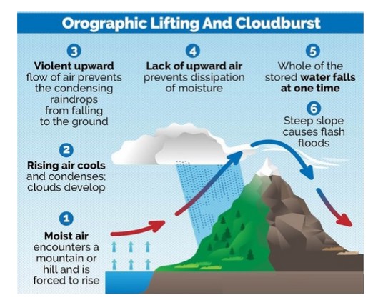
Reasons for occurrence of cloudbursts:
- Cloudbursts happen when warm, moist air quickly rises over mountains, cools down, and turns into heavy rain. This process, called orographic lift, causes the air to release a large amount of rain in a short time.
- Sudden mixing of warm and cold air
- Strong upward air movement (convection) and high moisture in the air at high altitudes
Why Do Cloudbursts Happen In The Hills?
- Topography: Mountains force moist air to rise rapidly, causing sudden cooling and condensation.
- Weather Conditions: Warm air with high moisture content meets cooler air at high altitudes. This results in intense convection and localised torrential rain.
Can cloudbursts be forecast?
- The India Meteorological Department (IMD) forecasts rainfall events well in advance, but it does not predict the quantum of rainfall, in fact, no meteorological agency does.
- IMD gives general rainfall forecasts (light, heavy, very heavy), but not exact amounts.
- These forecasts are for large areas like districts or states, not specific locations.
- Cloudbursts can’t be predicted exactly due to tech limitations and lack of dense instruments.
- However, warnings for very heavy rain (which may lead to cloudburst-like events) are given 6–12 hours in advance.
Impacts of cloud burst:
- Flash Floods: The most immediate and destructive impact is the rapid overflowing of rivers and streams, leading to widespread flooding of low-lying areas.
- Landslides and Mudslides: The excessive water saturates the soil on slopes, leading to the rapid downward movement of earth, rocks, and debris, causing significant destruction and posing a threat to human lives and infrastructure.
- Soil Erosion: The intense rainfall can wash away topsoil, degrading the land and negatively affecting agriculture.
- Land Subsidence: The weakening of the ground due to excessive water absorption can cause the sudden sinking or settling of the Earth’s surface
- Loss of Life: The suddenness and intensity of cloudbursts often leave little time for evacuation.
- Damage to Infrastructure: Roads, bridges, homes, and public utilities can be severely damaged or completely destroyed.
While the term “cloudburst” often evokes images of catastrophic floods and landslides, it’s crucial to adopt a nuanced approach, avoiding knee-jerk reactions and recognizing that not all instances of heavy rainfall are cloudbursts. While the unpredictable ferocity of cloudbursts remains a formidable challenge, a proactive blend of scientific innovation, infrastructure resilience, and community-centric preparedness offers the compass to navigate their escalating threat, particularly in fragile ecosystems like the Himalayas.

