5548Link for the test: Click2Attempt (Let us know your score in comments)
We have started our Open SIP program in conjunction with our PAID program (Click2Know all details of the program)
We will be running this special FREE initiative on daily basis providing students with revision questions for static subjects as well as current affairs starting from June 2017
Test 38 as per schedule (Click2View) is Misc Test 14 (Geography)
Liked the test? You can join our FLT program containing more such high-level questions. The module contains 11 FLTs (8 paper 1 TS + 3 CSAT)
Know all details about the program and join here: Click2Join
Want to do quick revision for Prelims? Join our SIP Comprehensive or SIP Mini modules giving you Static & Dynamic subjects coverage through video lectures
Link for the test: Click2Attempt (Let us know your score in comments)
We have started our Open SIP program in conjunction with our PAID program (Click2Know all details of the program)
We will be running this special FREE initiative on daily basis providing students with revision questions for static subjects as well as current affairs starting from June 2017
Test 37 as per schedule (Click2View) is Misc Test 13 (History)
Liked the test? You can join our FLT program containing more such high-level questions. The module contains 11 FLTs (8 paper 1 TS + 3 CSAT)
Know all details about the program and join here: Click2Join
Want to do quick revision for Prelims? Join our SIP Comprehensive or SIP Mini modules giving you Static & Dynamic subjects coverage through video lectures
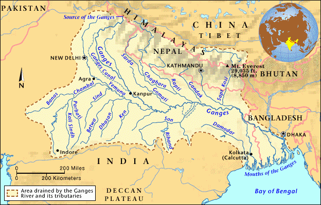
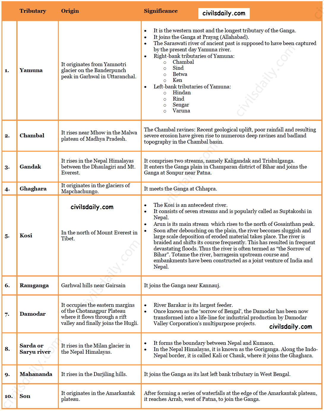
The Ganga river system is the largest in India having a number of perennial and non-perennial rivers originating in the Himalayas in the north and the Peninsula in the south, respectively. It accounts for 26.3% of the geographical area of the country and is shared by ten states.
Ambala is located on the water divide between Indus and Ganga.
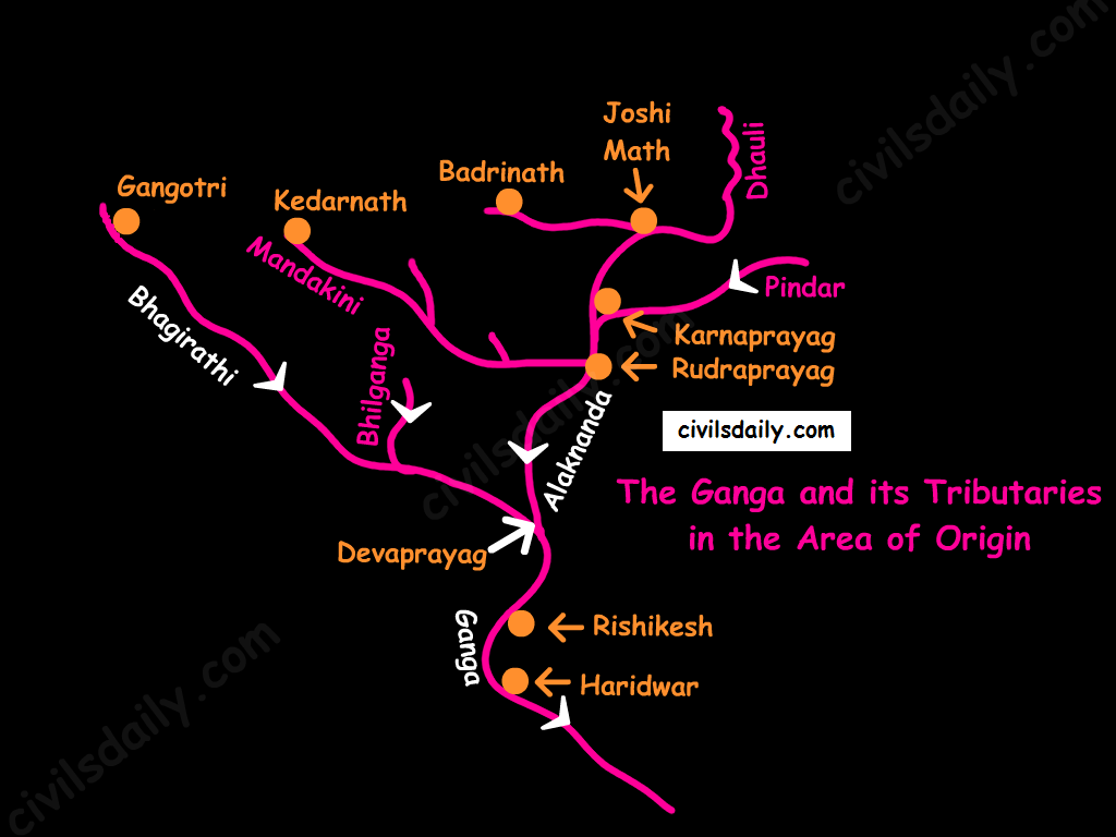
Origin: It rises in the Gangotri glacier near Gaumukh in the Uttarkashi district of Uttaranchal. Here, it is known as the Bhagirathi. At Devprayag, the Bhagirathi meets the Alaknanda; hereafter, it is known as the Ganga.
The Ganga and its Tributaries in the Area of Origin
The river-course:
The Ganga enters the plains at Haridwar.
From here, it flows first to the south, then to the south-east direction to reach Allahabad. Here it is joined by the Yamuna.
Further, near Rajmahal hills, Ganga turns south-east and bifurcates at Farakka into Bhagirathi – Hugli in West Bengal and as the Padma in Bangladesh.
The river finally discharges itself into the Bay of Bengal near the Sagar Island.
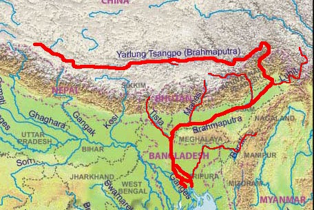
Origin: The Brahmaputra has its origin in the Chemayungdung glacier of the Kailash range near the Mansarovar lake. Mariam La separates the source of the Brahmaputra from the Manasarovar Lake.
The river-course:
Most of the course of the Brahmaputra lies in Tibet, popularly known as Tsangpo. It flows eastwards parallel to the Himalayas. It receives a large number of tributaries in Tibet. The first major tributary is the Raga Tsangpo meeting the Tsangpo near Lhatse Dzong.
After reaching Namcha Barwa, it takes a “U” turn (also known as Hair Pin turn) and enters India west of Sadiya town in Arunachal Pradesh through the deep Dihang or Siang gorge of Himalayas. Here initially it is called as Siang and then as Dihang.
It is joined by Dibang, Lohit, Kenula and many other tributaries and finally forms the Brahmaputra in Assam.
It then enters into Bangladesh near Dhubri and flows southward. In Bangladesh, the Tista joins it on its right bank from where the river is known as the Jamuna. [Note: The Tista was a tributary of the Ganga prior to the floods of 1787 after which it diverted its course eastwards to join the Brahmaputra.]
The Jamuna and Ganga confluence at Goalundo and afterwards are called as the Padma. Further south, Padma is joined by Meghna (Barak river in India) and thence onward it is known as Meghna to finally merge in the Bay of Bengal.
It is called:
The Tsangpo in Tibet ( Tsangpo = ‘the purifier.’)
The Brahmaputra in India
The Jamuna in Bangladesh
Major left bank tributaries:
Burhi Dihing,
Dhansari (South)
Kalang
Major right bank tributaries:
Subansiri ( It has its origin in Tibet and is an antecedent river.)
Kameng
Manas
Sankosh
Characteristic Features:
River Brahmaputra is a little longer than the river Indus.
It forms a spectacular Grand Canyon – like canyon in Tibet.
The river is nearly 16 km wide at Dibrugarh and forms many islands, the most important of which is Majuli. Majuli is the world’s largest riverine island and India’s first island district.
The Brahmaputra has a braided channel. It carries a lot of silt and there is excessive meandering.
The Brahmaputra is well-known for floods, channel shifting and bank erosion. This is due to the fact that most of its tributaries are large, and bring large quantity of sediments owing to heavy rainfall in its catchment area.
As a part of revision for Prelims 2018, Here’s a Factoid to brush up your concepts
#1. Name of the scheme : Vittiya Saksharata Abhiyan (VISAKA)
Objectives : To make people aware about cashless economic system.
Salient Features : Financial literacy
Nodal Ministry : Ministry for Human Resource Development (MHRD)
#2. Name of the scheme : Pradhan Mantri Gramin Digital Saksharta Abhiyan(PMDISHA)
Objectives : To make 6 crore rural households digitally literate
Salient Features : 1.It is expected to be one of the largest digital literacy programmes in the world. 2.Under the scheme, 25 lakh candidates will be trained in the FY 2016-17; 275 lakh in the FY 2017-18; and 300 lakh in the FY 2018-19. 3.To ensure equitable geographical reach, each of the 250,000 Gram Panchayats would be expected to register an average of 200-300 candidates.
Nodal Ministry : The Ministry of Electronics and Information Technology (MeitY)
All aspirants who are giving tomorrow’s test should discuss all there doubts/queries about any question on this thread and not in the comments section of the test
Around 20 questions of the test can be solved using Tikdam method
Tikdams explanations in those selected questions are given in the explanation column itself
By closely observing those questions after every test you will gradually learn the art of Tikdams which will assist you in clearing the UPSC prelims
Highlights of tomorrow’s test:
Q.1) Consider the following provisions of the constitution
1. Election of the President and its manner.
2. Power of Parliament to amend the Constitution and its procedure (Article 368 itself).
3. Directive Principles of State Policy
4. Fundamental Rights
Which of the above provisions can be amended by the special majority and consent of the states?
a) 1 and 3 only
b) 3 and 4 only
c) 1 and 2 only
d) 1,2 and 4 only
Q.2) Consider the statements about Systemically Important Financial Institutions (SIFIs)
1. The idea of SIFI has emerged from the Pittsburgh summit of world bank.
2. Systemically Important Financial Institutions (SIFIs) are perceived as institutions that are Too Big to Fail (TBTF).
3. when an institution is identified as SIFI, necessarily, it becomes an obligation for it to maintain an addition Tier 1 capital.
Which of the statements given above is/are correct ?
a) 1 and 2 only
b) 2 only
c) 1 and 3 only
d) 2 and 3 only
Q.3) Which of the following states shares boundaries with the maximum number of other states of India?
a) Uttar Pradesh
b) M.P
c) Assam
d) Telangana
Q.4) The sixth century BCE which is regarded as a major turning point in Indian history is associated with which of the following?
1. Use of silver for the first time
2. Development of coins
3. Practice of “gana” oligarchies in mahajanpadas
Select the correct answer using the codes given below.
Link for the test: Click2Attempt (Let us know your score in comments)
We have started our Open SIP program in conjunction with our PAID program (Click2Know all details of the program)
We will be running this special FREE initiative on daily basis providing students with revision questions for static subjects as well as current affairs starting from June 2017
Test 36 as per schedule (Click2View) is Misc Test 12 (August + September CA)
Liked the test? You can join our FLT program containing more such high-level questions. The module contains 11 FLTs (8 paper 1 TS + 3 CSAT)
Know all details about the program and join here: Click2Join
Want to do quick revision for Prelims? Join our SIP Comprehensive or SIP Mini modules giving you Static & Dynamic subjects coverage through video lectures
As a part of revision for Prelims 2018, Here’s a Factoid to brush up your concepts
Name of the scheme: National Skill Development Mission
Objectives : NSDM will provide a strong institutional framework at the Centre and States for implementation of skilling activities in the country.
Salient Features : The Mission will have a three-tiered, high powered decision making structure: 1. At its apex, the Mission’s Governing Council, chaired by the Prime Minister, will provide overall guidance and policy direction. 2. The Steering Committee, chaired by Minister in Charge of Skill Development, will review the Mission’s activities in line with the direction set by the Governing Council. 3. The Mission Directorate, with Secretary, Skill Development as Mission Director, will ensure implementation, coordination and convergence of skilling activities across Central Ministries/Departments and State Governments.
Nodal Ministry : Ministry of Skill Development and Entrepreneurship
Name of the scheme : Nirbhaya Fund
Objectives : -Nirbhaya Fund is an Indian rupee 10 billion corpus announced by Government of India in its 2013 Union Budget. -According to the then Finance Minister P. Chidambaram, this fund is expected to support initiatives by the government and NGOs working towards protecting the dignity and ensuring safety of women in India. -Nirbhaya (fearless) was the pseudonym given to the 2012 Delhi gang rape victim to hide her actual identity.
Nodal Ministry: Earlier Ministry of Home Ministry, Now Ministry of Women & Child
Link for the test: Click2Attempt (Let us know your score in comments)
We have started our Open SIP program in conjunction with our PAID program (Click2Know all details of the program)
We will be running this special FREE initiative on daily basis providing students with revision questions for static subjects as well as current affairs starting from June 2017
Test 35 as per schedule (Click2View) is Misc Test 11 (Economy)
Liked the test? You can join our FLT program containing more such high-level questions. The module contains 11 FLTs (8 paper 1 TS + 3 CSAT)
Know all details about the program and join here: Click2Join
Want to do quick revision for Prelims? Join our SIP Comprehensive or SIP Mini modules giving you Static & Dynamic subjects coverage through video lectures
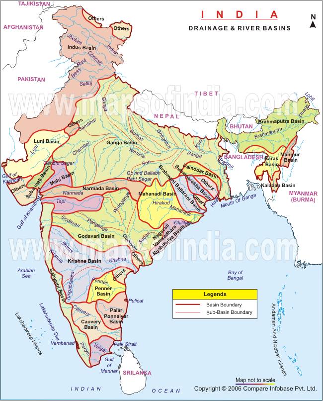
1. On the basis of discharge of water – the Arabian Sea drainage and the Bay of Bengal drainage:
On the basis of discharge of water (orientations to the sea), the drainage system of India may be grouped into:
the Arabian Sea drainage
the Bay of Bengal drainage
They are separated from each other by the Delhi ridge, the Aravalis and the Sahyadris (water divide is shown by a line in the following map).
Source: NCERT
Nearly 77 percent of the drainage area consisting of the Ganga, the Brahmaputra, the Mahanadi, the Krishna, etc. is oriented towards the Bay of Bengal while 23 percent comprising the Indus, the Narmada, the Tapi, the Mahi and the Periyar systems discharge their waters in the Arabian Sea.
1. Rivers of the inland drainage basin (endorheic basin): When a river does not reach the sea but disappears into the sand, such a region is called an area of inland drainage. Inland drainage streams are ephemeral streams (short-lived). E.g.:
The Ghaggar river in Haryana, which is supposed to be remnant of the proverbial ancient Saraswati river, gets lost in dry sands near Hanumangarh in Rajasthan.
The Luni river in Rajasthan originates near Ajmer and after flowing through Thar desert gets lost in the Rann of Kutch.
The Aksai Chin region in Ladakh too has some inland drainage.
2. On the basis of the size of the watershed:
Major river basins – with more than 20,000 sq. km of catchment area. It includes 14 drainage basins such as the Ganga, the Brahmaputra, the Krishna, the Tapi, the Narmada, the Mahi, the Pennar, the Sabarmati, the Barak, etc.
Medium river basins – with catchment area between 2,000-20,000 sq. km incorporating 44 river basins such as the Kalindi, the Periyar, the Meghna, etc.
Minor river basins – with catchment area of less than 2,000 sq. Km, these include 55 river basins.
3. On the basis of the mode of origin, nature and characteristics:
The Himalayan drainage, and
The Peninsular drainage.
There is no clear-cut line of demarcation between these two drainage systems, as many of the peninsular rivers like the Chambal, Betwa, Sind, Ken and Son are much older in age and origin than the Himalayan rivers.
Let’s follow this line of classification and look at the drainage system of India in detail. We begin with the Himalayan drainage.
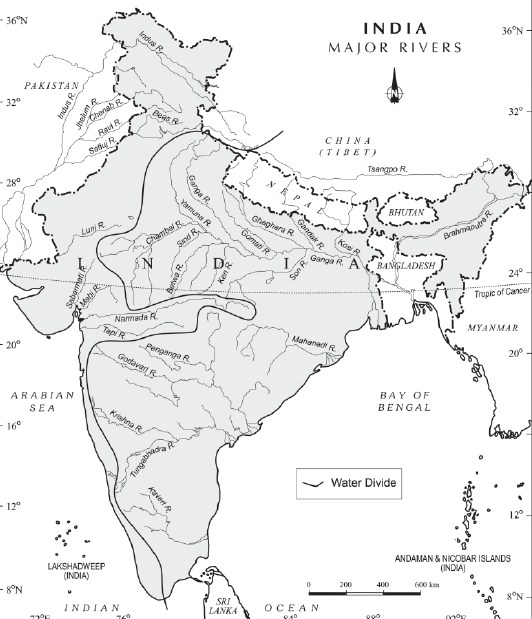
The Himalayan Drainage system:
It consists of the rivers originating in the Himalayan and trans-Himalayan region. It further consists of three river systems namely:
the Ganga,
the Indus, and
the Brahmaputra river systems.
Since these are fed both by the melting of snow and precipitation, rivers of this system are perennial.
The various geographical features made by the Himalayan rivers are:
In upper reaches (Youthful stage): Gorges, V-shaped valleys, rapids, waterfalls, truncated spurs etc.
In plain areas or middle part (Mature stage): While entering the plains, they form depositional features like flat valleys, ox-bow lakes, flood plains, braided channels, and deltas near the river mouth. Over the plains, they display a strong meandering tendency and shift their courses frequently.
Evolution of the Himalayan Drainage System:
There is a difference of opinion about the evolution of the Himalayan Rivers. However, geologists believe that:
A mighty river called Shiwalik or Indo-Brahma traversed the entire longitudinal extent of the Himalaya from Assam to Punjab and onwards to Sind, and finally discharged into the Gulf of Sind near lower Punjab during the Miocene period some 5-24 million years ago.
Evidences: The remarkable continuity of the Shiwalik and its lacustrine origin and alluvial deposits consisting of sands, silt, clay, boulders and conglomerates support this viewpoint.
It is opined that in due course of time Indo–Brahma river was dismembered into three main drainage systems:
the Indus and its five tributaries in the western part;
the Ganga and its Himalayan tributaries in the central part; and
the stretch of the Brahmaputra in Assam and its Himalayan tributaries in the eastern part.
The dismemberment was probably due to the Pleistocene upheaval in the western Himalayas, including the uplift of the Potwar Plateau (Delhi Ridge), which acted as the water divide between the Indus and Ganga drainage systems.
Likewise, the downthrusting of the Malda gap area between the Rajmahal hills and the Meghalaya plateau during the mid-pleistocene period, diverted the Ganga and the Brahmaputra systems to flow towards the Bay of Bengal.
Let’s take up the three major river systems of the Himalayan drainage individually:
1. The Indus River System
It is one of the largest river basins of the world. A little over one-third of the Indus basin is located in India; in the states of Jammu & Kashmir, Himachal Pradesh and Punjab. The rest of the portion is in Pakistan.
The Indus also known as the Sindhu, is the westernmost of the Himalayan rivers in India.
Origin: It originates from a glacier near Bokhar Chu in the Kailash Mountain range (Tibetan region). In Tibet, it is known as ‘Singi Khamban; or Lion’s mouth.
The river-course:
The Indus cuts through Himalayas and enters India near Damchok.
flows in India only through the Leh district in Jammu and Kashmir.
It enters into Pakistan near Chillar in the Dardistan region through a deep gorge near the hair-pin bend of Nanga Parbat.
It finally discharges into the Arabian Sea, east of Karachi.
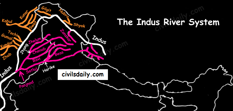
The right-bank tributaries of Indus:
Shyok
Gilgit
Hunza
Nubra
Kabul
Khurram
Tochi
Gomal
Sangar
Kunar
The left-bank tributaries of Indus:
Zaskar
‘Panjnad’ joins Indus a little above Mithankot). The Panjnad is the name given to the five rivers of Punjab, namely:
Satluj
Beas
Ravi
Chenab
Jhelum
Chief Characteristics:
The Indus drains the largest number of glaciers of Himalayas, Ladakh, Zaskar, and Kailash.
The Indus plain has a very gentle slope.
Indus and its Tributaries
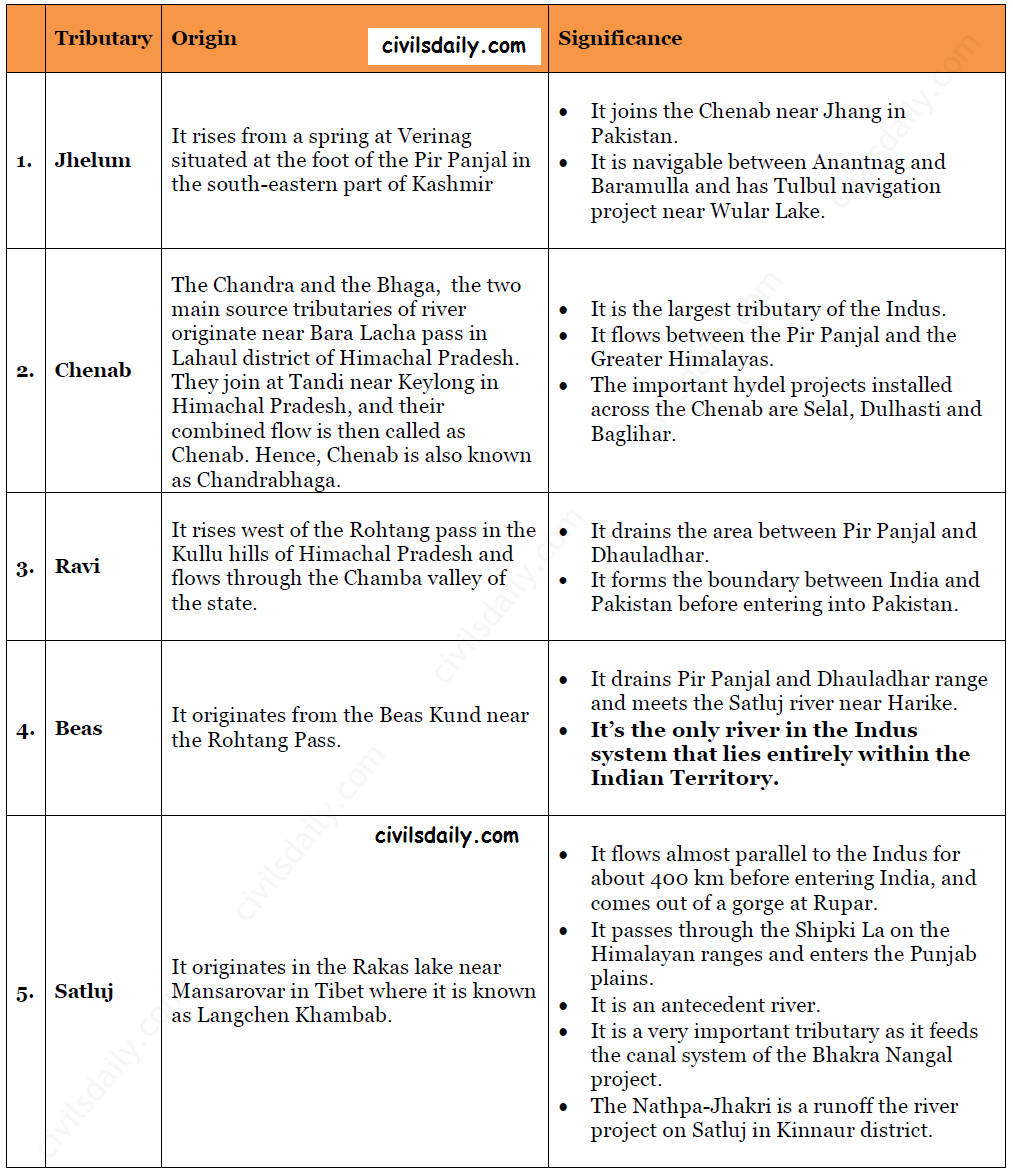
Let’s look at some important tributaries of Indus:
Important Tributaries of Indus and their Characteristic Features
The Indus water treaty: The waters of the Indus river system are shared by India and Pakistan according to the Indus Water Treaty signed between the two countries on 19th September 1960. According to this treaty, India can utilise only 20 percent of its total discharge of water. The Indus water treaty was recently in news. Remember why? Read here!