💥UPSC 2026, 2027, 2028 UAP Mentorship (March Batch) + Access XFactor Notes & Microthemes PDF

Search results for: “”

  • 5 August 2017 | Prelims Daily with Previous Year Questions & Tikdams

    Q.1) India’s first private sector missile sub-systems manufacturing facility, for manufacturing ‘Spike’ Missile, was inaugurated near Hyderabad. The Spike missile is a
    a) Inter-Continental Ballistic Missile
    b) Torpedo
    c) Anti-tank Missile
    d) Cruise Missile

    Q.2) The Purchasing Managers’ Index(PMI) is based on
    1. New orders
    2. Inventory levels
    3. production
    4. Supplier deliveries
    5. Employment environment
    Select the correct answer using the codes given below.
    a) 1, 2, 3, 4 and 5
    b) 2, 3 and 4 only
    c) 1, 2 and 5 only
    d) 1, 2, 4 and 5 only

    Q.3) Consider the following statements regarding the ‘P5+1’ countries:
    1. Germany is a member of ‘P5+1’.
    2. All the five permanent members of UN Security Council are not members of ‘P5+1’
    Which of the statements given above is/are correct?
    a) 1 only
    b) 2 only
    c) Both are correct
    d) None is correct

    Q.4) Nyctalopia is an eye disease. It is caused due to deficiency of
    a) Vitamin E
    b) Vitamin K
    c) Vitamin B
    d) Vitamin A

    Q.5) Which of the following statements regarding the ‘Sustainable Development Goals (SDGs)’ is/are correct?
    1. It is a set of 17 “Global Goals” with 169 targets.
    2. It is a non-binding document.
    Select the correct options using the codes given below.
    a) 1 only
    b) 2 only
    c) Both are correct
    d) Neither 1 nor 2

    Q.6) Which one of the following pairs of islands is separated from each other by the ‘Ten Degree Channel’? (CSE: 2014)
    a) Andaman and Nicobar
    b) Nicobar and Sumatra
    c) Maldives and Lakshadweep
    d) Sumatra and Java

    Q.7) Consider the following pairs : (CSE: 2014)
    Programme/ Project Ministry
    1. Drought­Prone Area Programme : Ministry of Agriculture
    2. Desert Development Programme : Ministry of Environment and Forests
    3. National Watershed Development : Ministry of Rural Development
    Project for Rainfed Areas
    Which of the above pairs is/are correct?
    a) 1 and 2 only
    b) 3 only
    c) 1, 2 and 3
    d) None

    Q.8) With reference to Bombay Natural History Society (BNHS), consider the following statements : (CSE: 2014)
    1. It is an autonomous organization under the Ministry of Environment and Forests.
    2. It strives to conserve nature through action­based research, education and public awareness.
    3. It organizes and conducts nature trails and camps for the general public.
    Which of the statements given above is/are correct?
    a) 1 and 3 only
    b) 2 only
    c) 2 and 3 only
    d) 1, 2 and 3


    IMPORTANT STUFF: 

    1. Daily newscards have been enriched with back2basics and note2students – Make notes daily

    2. Join Full Year Prelims TS – prelims.civilsdaily.com

    3. Solutions will be uploaded at 11.30 p.m. Click here for Solutions

    4. For attempting previous Prelims Daily Questions – Click here

  • Psir optional subject for 2018 mains

    Psir4upsc.blogspot.com please visit this blog and start answer writing for PSIR as optional subject. Daily questions are posted there.

  • Agroforestry

    What is Agroforestry?

    Agroforestry is a sustainable management mechanism for land that:

    • increases overall production,
    • combines agricultural crops, tree crops, forest plants and animals simultaneously, and
    • applies management practices that are compatible with cultural practices of the local population.

    It is a type of social forestry in which an individual farmer undertakes tree farming and grows fodder plants, grasses and legumes on his own land. In agroforestry trees are considered a crop and become a part of crop combinations.

    Some Patterns of Agroforestry

    There is an increasing number of farmers who plant trees either along the boundaries or in the whole field/farm as a crop. In fact, in the northern plains of India, trees are planted by most of the farmers irrespective of the size of their holdings. The large farmers and absentee landlords generally put a part of their holdings or total agricultural area under tree crops.

    The main advantage of agroforestry is considered to be its positive impact on the soil. Let’s understand the impact of trees on the soil.

    How trees improve soils:

    1. Litter or Mulch:

    During the lifetime of a tree, leaves, twigs and branches die and fall to the ground as litter. Litter contributes to the organic-matter content of the soil after it decomposes. A soil that is rich in organic matter has a better capacity to absorb and retain water and thus is also more resistant to erosion. A good cover of litter or mulch can also be very effective in suppressing weeds.

    2. Increase nutrient content of soil:

    • Nutrient Uptake from deeper layers of soil: Tree roots normally penetrate deeper into the soil than the roots of crops. Though not experimentally verified, trees are generally considered more efficient than crops in taking up nutrients released by weathering deep in the soil.
    • Nutrients from the atmosphere: The presence of a tree reduces the wind speed and creates good conditions for the deposition of dust. Nutrients in the atmosphere are conveyed to the soil when they are dissolved in rain or settle with dust. Rain water dripping from leaves and flowing along the branches carries the nutrients to the ground, together with those released from the tree itself and associated plants growing on it. It is known that the amounts of nutrients reaching the ground in this way are substantial.
    • Nitrogen Fixation: Many leguminous trees and a few non-leguminous ones have the ability to fix atmospheric nitrogen through symbiosis with bacteria or fungi in root nodules. The fixation of nitrogen has been proven and found to be a significant factor in soil fertility. Also, the litter from nitrogen-fixing plants is often rich in nitrogen which is added to the soil when the litter or mulch decomposes.

    3. Protection from soil erosion

    Tree roots and stems reduce surface run-off, nutrient leaching and soil erosion.

    Source

    Some Other Benefits of Agroforestry:

    1. Environmental Benefits:

    • Reduction of pressure on natural forests. It is also recognized that Agroforestry is perhaps the only alternative to meeting the target of increasing forest or tree cover to 33 percent from the present level of less than 25 per cent, as envisaged in the National Forest Policy (1988).
    • Agroforestry is known to have the potential to mitigate the climate change effects through:
      • microclimate moderation and natural resources conservation in the short run, and
      • carbon sequestration in the long run. Agroforestry species are known to sequester as much carbon in below-ground biomass as the primary forests, and far greater than the crop and grass systems.
    • When strategically applied on a large scale, with an appropriate mix of species, agro-forestry enables agricultural land to withstand extreme weather events, such as floods and droughts, and climate change.

    2. Economic benefits:

    • A greater output of food, fuel wood, fodder and timber.
    • Increase in levels of farm income due to improved and sustained productivity.
    • Agroforestry leads to a reduction in the incidence of total crop failure, which is common to single cropping or monoculture systems. This is because such systems are structurally and functionally more complex than monoculture.
    • The absentee landlords go for agroforestry to retain the title of the land and to increase their income. It provides an alternative to land owners to manage their agricultural land in absence of family labour.
    • Agroforestry has significant potential to provide employment to the rural and urban population through production, industrial application and value addition ventures. Current estimates show that about 65 % of the country’s timber requirement is met from the trees grown on farms.

    3. Social benefits :

    • Improvement in rural living standards from sustained employment and higher income.
    • Makes the villagers self-dependent at the village-level.

    Despite the numerous material and geo-climatic benefits, agroforestry if not carefully planned can have some adverse effects on agricultural land. Some of these are:

    • In the fields along which trees have been planted, the productivity per unit area decreases, as in at least about two meters from the trees the moisture content in the soil is significantly reduced. Also, the combination of trees and crops must be so chosen so as to minimise the competition between their roots for moisture.
    • Unscientific planning can also negatively impact the agricultural productivity of the land. E.g. growing trees with photophilic i.e. light-loving plants.
    • Pests and Diseases: Mixtures of trees and crops make a more diverse environment than monocropping. A diverse environment enables a greater variety of species of all kinds of organisms — both desirable and less desirable — to thrive. With increased diversity, the risks of pests and diseases may also increase. On the other hand, a greater diversity of species also allows for better regulatory mechanisms which may reduce the seriousness of the pests and diseases. Careful planning is necessary so that the organisms promoted by one component in the system and are not harmful to the other component or components.

    Thus, for an agroforestry system to be successful, a careful and scientific approach is required which incorporates knowledge from both agriculture and forestry.

    Source

    Apart from these, certain shortcomings have been observed in the case of agroforestry programs in India:

    • The tendency of farmers to opt for market-oriented trees rather than the trees which are more ecologically suited or are locally needed (fuelwood/fodder).
    • Agroforestry has benefitted the big farmers more than the marginal and small farmers. Many of the absentee landlords plant commercial trees in their agricultural landholdings to save their land from dispossession. This programme is said to have encouraged absentee landlordship.
    • The diversion of good agricultural land from cereal and commercial crops may create the scarcity of food and industrial raw material.
    • Possible negative impact on crop production because of planting trees on fertile lands.

    Thus, while the potential benefits of agroforestry are well documented, particular aspects of these systems need to be adapted to suit the areas where they are introduced. These adaptations primarily involve the selection of the ideal combinations of trees, shrubs and crops that will benefit each other, the environment and the income of the small-scale farmers.

    National Agroforestry Policy 2014:

    In February 2014, India became the first nation in the world to adopt an agroforestry policy. Agroforestry was earlier covered as a part of other policies e.g. the National Forest Policy, the Green India Mission etc.

    The Policy aims to improve coordination, convergence and synergy between various elements of agroforestry, scattered across various existing missions, programme and schemes under different ministries—agriculture, rural development and environment.

    Objectives of the National Agroforestry Policy 2014:

    • Promote agroforestry to increase farm income and livelihoods of rural households, especially the small and marginal farmers.
    • Protect and stabilise ecosystems, and promote resilient cropping and farming systems to minimise the risk during extreme climatic events.
    • Simultaneously provide raw material to wood based industries. Thus create new avenues for rural employment, and reduce pressure on the forests.
    • To develop capacity and strengthen research in agroforestry and create a massive people’s movement for achieving these objectives.
  • Part 4 | Cropping Patterns and Systems in India

    Cropping Pattern refers to a yearly sequence and spatial arrangement of crops and fallow in a given area

    Cropping pattern used on a farm and its interaction with farm resources, other farm enterprises and available technology that determines its make up, is called a cropping system.

    A farmer’s choice of crops is governed by several sets of factors: Physical, Social and Economic. But, by and large, most of the Indian farmers go for cultivation of a number of crops at their farms and rotate a particular crop combination over a period of 3-4 years. It results in a multiplicity of cropping systems, which remains dynamic in time and space making it difficult to precisely determine the spread of different cropping systems.

    Scientists have identified more than 250 cropping systems being followed throughout the country but it is estimated that only 30 major cropping systems are prevalent (except the areas under monocropping due to moisture or heat conditions)

    A large diversity of cropping systems exists under rainfed and dryland areas with an overriding practice of intercropping. This is because of greater risks involved in cultivating a large area under a particular crop. While in areas with assured irrigation only a few cropping systems are followed and they have a considerable coverage across the region and contribute significantly to foodgrains production at the national level.

    Types of Cropping Systems in India:

    Broadly speaking there are 3 types of cropping systems in India:

    1. Sequential – In sequential multiple cropping, farmers use short duration crops and intensive input management practices. E.g.

    • In Maharashtra:- Rice-Frenchbean-Groundnut
    • In Rainfed Areas:- Pigeon Pea – Wheat

    2. Inter-Cropping – Growing two or more crops simultaneously on the same field is called intercropping. In this case, crop intensification is in both temporal and spatial dimension. There is an inter-crop competition during all or in part of crop growth. E.g.

    • Maize and Groundnut in Ranchi
    • Cotton and Groundnut in Junagarh

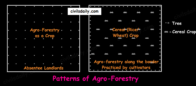
    3. Alley Cropping System – Growing of annual crops with multipurpose perennial shrubs/trees is called alley cropping. It is a way of increasing production potential under fragile environments. It is recommended to meet food, fodder and fuel needs besides improving soil fertility e.g. In the salt affected alluvial soil areas of Modipuram, alley cropping of rice-wheat sequence is done with trees like babool.

    Major Cropping Systems in India:

    The crop occupying the highest percentage of sown area of the region is taken as the base crop and all the other possible alternative crops sown in the region as substitutes (i.e. spatial variation) for the base crop in the same season or as the crops that fit in with the rotation in the subsequent seasons (i.e. temporal variations) are considered in the pattern.

    1. Rainy Season Cropping Systems: Among the Kharif Crops – Rice, Sorghum, Pearl Millet (Bajra), Maize, Groundnut and Cotton are the prominent crops to be considered as the base crops for describing the Kharif Cropping Patterns.

    1. Rice Based Cropping Patterns: Rice is grown in the high rainfall area or in the areas where supplemental irrigation is available to ensure good yields. At an all India Basis, nearly 80% of rice is sown during June to September and the rest during the remaining season. E.g.
      • With rice, other crops being cotton, vegetables and fruits (in Meghalaya)
      • Jute as an alternative to rice (in Orissa, coastal Andhra Pradesh, Bihar, Jharkhand, Assam etc.)
      • In Bihar, the alternative crops being pulses, wheat, maize, jute, sugarcane and oilseeds
    2. Kharif Cereals other than rice:
      • Maize-based cropping systems: Maize is grown in high rainfall areas or on soil with a better capacity for retaining moisture, but with a good drainage.
      • Sorghum based cropping system: Grown in medium rainfall regions. These systems are popular in Maharashtra and Madhya Pradesh. The alternative crops being cotton, pulses, groundnut, and small millets in Maharashtra.
      • Pearl-Millet based cropping system –Pearl millet is a more drought resistant crop than several other cereal crops and is generally preferred in low or less dependable rainfall and on light textured soils. These are popular in Rajasthan, Maharashtra, Gujarat and Uttar Pradesh. E.g. in Rajasthan with pulses, groundnut, oilseeds, etc.
    3. Groundnut based cropping systems: These are popular in Andhra Pradesh, Gujarat, Karnataka, Tamil Nadu and Maharashtra. E.g. In Andhra Pradesh and Tamil Nadu, rice forms an alternative; in Karnataka, Sorghum is the main alternative crop, whereas cotton, tobacco, sugarcane and wheat are also grown here.
    4. Cotton based cropping systems: These are popular in Maharashtra, Gujarat, Andhra Pradesh and Punjab. E.g. Cotton with other crops:
      1. Sorghum (Kharif and rabi), groundnut, pulses and wheat etc;
      2. With irrigation in some places sugarcane and rice are also grown with cotton.

    2. Winter Cropping Systems: Among the Rabi Crops, wheat together with barley and oats, sorghum and chickpea are the main base crops. Generally, wheat and chickpea are concentrated in the subtropical region in northern India, whereas Rabi sorghum is grown mostly in the Deccan.

    1. Wheat and Chickpea based cropping systems: Wheat and Chickpea are grown under identical climate and can be substituted for each other. E.g. alternative crops in Madhya Pradesh being Kharif sorghum groundnut, oilseeds, cotton, small millets etc. In Punjab, the alternative crops are rice, mailze, cotton, pearl-millet etc.
    2. Rabi Sorghum based cropping systems: These are popular in Maharashtra, Karnataka and Andhra Pradesh. E.g. in Maharashtra, the alternative crops are pearl millet, pulses, oilseeds and tobacco etc.

    3. Plantation and other commercial crops:

    • Sugarcane, Tobacco, Potato, Jute, Tea, Coffee, Coconut, Rubber, Spices and condiments are important crops. Some of these are seasonal, some annual, some perennial.
    • Generally, the areas occupied by these crops are very limited compared with those of food and other crops. Nevertheless, they are important from commerce point of view.
    • Besides the above-mentioned crops, there are certain horticultural crops like apple, mango and citrus fruits.
    • E.g. in the jute growing areas, rice is the usual alternative crop; in Punjab, Bihar, Haryana and Uttar Pradesh, wheat and maize are rotation crops with sugarcane.

    4. Mixed Cropping:

    • Crop Mixtures, for example, pulses and some oilseeds are grown with maize, sorghum and pearl millet.
    • Lowland Rice is invariably grown unmixed, but in upland rice, several mixtures are prevalent. E.g. In un-irrigated areas of the north, during rabi season, wheat, barley and chickpea are the mixtures of grain crops.
    • Note: Mixed Cropping was considered by some researchers a primitive practice, but now many researchers regard it as a more efficient way of using the land. [Mixed cropping ≠Mixed Farming; Mixed Farming = Farming + Animal Rearing. Note the difference!]

    Note4students: With this article, we conclude our discussion on Indian Agriculture. However, these articles only cover the geographical aspect of agriculture in India. For a comprehensive understanding and coverage of other aspects like economic, government schemes etc., do read our comprehensive article series on Indian Agriculture (Click here to read).

  • Part 2 | Important Food Crops (Rice, Wheat, Maize, Millets, Pulses and Barley) and Horticultural Crops

    Important Food Crops

    1. Rice:

    • Geographical Conditions of Growth:
      • Rice grows best in areas of warm, humid climate; rice requires temperatures between 20°C and 35°C and a well-distributed rainfall of about 100 cm or irrigation facilities.
      • Fertile soil. Delta and valley soils are the most suitable. Soils with higher clay content are preferred for its cultivation due to their better moisture retention capacity.
    • Important Producing Areas:
      • West Bengal (highest producer), Uttar Pradesh, Andhra Pradesh, Punjab (highest per hectare yield), Bihar, Orissa, Chhattisgarh, Assam, Tamil Nadu, Haryana.
      • About 25% of the arable land is used for the cultivation of rice.
    • On the basis of climatic conditions, three varieties of rice are found in India:
      • Winter/ Agahani/ Aman – Planted in July-August and harvested in October-December. 86% of the total rice cultivation comes under this variety.
      • Autumnal/ Kuari/Aus – Sown in May-June and harvested in September – October.
      • Summer/Boro – It is sown in November – December and harvested in March-April. It is grown on 1% of the total rice area.

    Note: All the above mentioned 3 varieties (aman, aus, boro) are grown in West Bengal and Assam.

    • Important varieties: IR-8, Jaya, Padma, Hamsa, Krishna, Sabarmati, and IET 1039.
    • India is the 2nd largest producer in the world after China.

    2. Wheat

    • Geographical Conditions of Growth:
      • It is a crop of temperate climate. The ideal temperature for its cultivation is about 15°-20°C and requires a moderate amount of rainfall of 25-75 cms. It can be grown in the drier areas with the help of irrigation.
      • Well drained loamy and clayey soils are ideal.
    • Important Producing Areas:
      • Wheat is cultivated on about 14% of the total arable area of the country.
      • There are two important wheat producing zones in the country – the Ganga-Satluj plains in the north-west and the black soil region in the Deccan.
      • In north India, wheat is sown in October – November and harvested in March – April. In south India, it is sown in September-October and harvested in December – January. Wheat takes lesser time in ripening in south India than that in the north because of hotter climatic conditions in the south.
      • Uttar Pradesh (highest producer), Punjab (highest yield per hectare), Madhya Pradesh, Haryana, Rajasthan, Bihar, Gujarat, Maharashtra, West Bengal, Uttarakhand.
    • Important varieties: Sonalika, Kalyan, Sona, Sabarmati, Lerma, Roso, Heera, Shera, Sonara-64.

    3. Maize

    • Geographical Conditions of Growth:
      • It is a crop of semi-arid climate and is used both as food and fodder.
      • A temperature of 21°C- 27°C and 50-100cm rainfall is suitable for its cultivation.
      • Alternate spells of rains and sunny weather are ideal for maize.
      • It is a Kharif Crop but in some states like Bihar, it is grown in the rabi season also.
      • It grows well in alluvial and red soils with good drainage. It can also be grown in mountainous soils.
    • Important Producing Areas:
      • It is grown on 3.6% of the total sown area in the country.
      • Karnataka, Uttar Pradesh, Bihar, Rajasthan and Andhra Pradesh are important maize producing states.
    • Important Varieties: Sartaz, Ganga, Deccan-103, Deccan-105, Dhawal, Prabhat, Arun, Kiran etc.

    4. Millets:

    Jowar, Bajra and Ragi are the important millets grown in India. Though these are known as coarse grains, these have high nutritional value. These are grown on 16.5% of the total sown area in the country.

    1. Bajra
      • Geographical Conditions of Growth:
        • It thrives in areas of warm, dry climate.
        • It requires an annual rainfall of 45cm and temperature ranging between 25 to 30°C.
        • It grows well on sandy soils and shallow black soil.
      • Important Producing Areas:
        • Rajasthan is the largest producer of bajra followed by Uttar Pradesh, Maharashtra, Gujarat and Haryana.
    2. Jowar
      • Geographical Conditions of Growth:
        • It is a rainfed crop mostly grown in moist areas which hardly needs irrigation.
        • This crop requires moderate rainfall of 30-100cms and high temperatures ranging from 20 to 32°C.
        • Both excessive moisture and prolonged drought are harmful.
        • Well drained light soils are ideal.
      • Important Producing Areas:
        • It is the third most important food crop with respect to area and production.
        • It is cultivated as the major food crop in semi-arid areas of the central and south India.
        • In north India, Jowar is mainly a Kharif crop whereas it is sown as both Kharif and Rabi in the southern states.
        • Maharashtra is the largest producer of jowar followed by Karnataka, Andhra Pradesh and Madhya Pradesh.
        • India is the largest producer of jowar in the world.
    3. Ragi
      • Ragi is very rich in iron, calcium, other micro-nutrients and roughage.
      • Geographical Conditions of Growth: It is a crop of dry regions and grows well on red, black, sandy, loamy and shallow black soils.
      • Important Producing Areas: Karnataka is the largest producer of Ragi followed by Tamil Nadu. Other states important for the production of ragi are Himachal Pradesh, Uttaranchal, Sikkim, Jharkhand and Arunachal Pradesh.

    4. Pulses

    • Major pulses that are grown in India: tur, urad, moong, masur, peas and gram.
    • Chief Characteristics:
      1. India is the largest producer as well as consumer of pulses in the world. About 20% of the pulses of the world are produced here.
      2. These are the major sources of protein in a vegetarian diet.
      3. Being leguminous crops, all the above-mentioned pulses (except tur) help in restoring soil fertility by fixing nitrogen from the air. Therefore these crops are mostly grown in rotation with other crops.
    • Geographical Conditions of Growth:
      1. Pulses need less moisture and survive even in dry conditions
    • Important Producing Areas: The major pulse producing areas are Madhya Pradesh, Uttar Pradesh, Rajasthan, Maharashtra and Karnataka. It is grown on about 11% of the total sown area in India.

    5. Barley

    • Geographical Conditions of Growth:
      • This is grown mainly as a dry crop.
      • This is the crop grown in the wheat producing area on the poor soil and in area of lower precipitation.
      • Although the geographical conditions required for its cultivation are similar to those for wheat, it has more tolerance for adverse environmental conditions.
    • Important Producing Areas: The major producers are Uttar Pradesh, Bihar and Madhya Pradesh.

    Horticultural Crops (Fruits, Vegetables, Flowers etc.)

    • The contribution of horticulture in the total agricultural produce of the country is 30.4% (Year 2012-13)
    • Fruits:

      • India produces 10% of the total fruit production in the world and is the second largest producer of fruits in the world.
      • India is the largest producer of mango, banana, cashew, cheekoo, and lemon in the word.
      • India produces both tropical and temperate fruits.
    • Vegetables:

      • India is the second largest producer of vegetables in the world and produces about 13% of the world’s vegetables.
      • India is an important producer of potato, pea, cauliflower, onion, cabbage, tomoato and brinjal.
  • Part 5 | Indian Soils – Arid, Saline and Alkaline, Peaty and Forest Soils

    We discussed in detail alluvial, black, red and laterite soils. Let’s continue the discussion and move on to the next soil types!

    Source

    5. Arid Soils

    • Formation: These are derived from the disintegration of adjacent rocks and are largely blown from coastal regions and Indus valley.
    • Areas: Arid soils are characteristically developed in western Rajasthan, which exhibit characteristic arid topography.
    • Soil Colour: Arid soils range from red to brown in colour.
    • Soil Texture: They are generally sandy to gravelly in texture and have a high percentage of soluble salts.
    • Other characteristic features:
      • These are saline in nature. In some areas, the salt content is so high that common salt is obtained by evaporating the saline water.
      • Due to the dry climate, high temperature and accelerated evaporation, they lack moisture and humus.
      • These soils are deficient in nitrogen and humus. The phosphate and iron content is normal. These soils are rich in minerals but the main limitation is the lack of water.
      • The soils exhibit poorly developed horizons.
      • Plants are widely spaced.
      • Chemical weathering is limited.
      • Lower horizons of the soil are occupied by ‘kankar’ layers because of the increasing calcium content downwards. The ‘Kankar’ layer formation in the bottom horizons restricts the infiltration of water, and as such when irrigation is made available, the soil moisture is readily available for a sustainable plant growth.
    • Suitable crops: If irrigated these soils give high agricultural returns. The availability of water from the Indira Gandhi canal has transformed the agricultural landscape of desert soils of western Rajasthan. These soils are mainly devoted to bajra, pulses, guar, fodder and less water requiring crops.

    6. Saline and Alkaline Soils

    • They are also known as Usara soils. Various local names for saline soils are Reh, Kallar, and Chopan, Rakar, Thur, Karl etc.
    • Formation:
      • These soils have developed in areas with dry climatic conditions (in areas having a little more rainfall than the areas of desert soils) accompanied by lack of proper drainage. In this situation, salts of sodium, calcium and magnesium are deposited on the upper layer of the soil by capillary action.

        Source

      • In the Rann of Kuchchh, the Southwest Monsoon brings salt particles and deposits there as a crust.
      • These soils are also formed when saline water spreads on the land at the time of high tide in coastal areas. Also, seawater intrusions in the deltas promote the occurrence of saline soils.
      • Salinization also occurs because of over-irrigation (canal irrigation/groundwater use) and in areas of high water table (as in the coastal areas of Maharashtra and Tamil Nadu).Salinity from irrigation can occur over time wherever irrigation occurs. This is because almost all water (even natural rainfall) contains some dissolved salts. When the plants use the water, the salts are left behind in the soil and eventually begin to accumulate. Also, excessive irrigation with dry climatic conditions promotes capillary action, which results in the deposition of salt on the top layer of the soil (See the following figure).

        Source

      • These are thus, intrazonal soils.
    • Areas: They occur in arid and semi-arid regions, and in waterlogged and swampy areas. These are more widespread in western Gujarat, deltas of the eastern coast and in Sunderban areas of West Bengal.
    • Soil Texture: Their texture ranges from sandy to loamy.
    • Other characteristic features:
      • Because of capillary action, the salts are sucked up in solution to the surface and form white encrustations on the surface (See the picture below).

        Source

      • The salt efflorescence of calcium, magnesium and sodium makes these soils infertile.
      • Saline soils contain an excess of neutral soluble salts of chlorides and sulphates whereas sodic or alkali soils contain sodium carbonates/ sodium bicarbonates.
      • They lack in nitrogen and calcium and have low water bearing capacity.
      • These soils can be reclaimed by improving drainage, by applying gypsum and/or lime, and by cultivating salt resistant crops like barseem, dhaincha and other leguminous crops.
      • The saline and alkaline soils may occur in any group of soils.
    • Crops grown: In coastal areas, coconut trees are found in plenty in these soils. As discussed above, cultivating salt resistant crops like barseem, dhaincha and other leguminous crops can help in reclaiming these soils.
    • Note: In the areas of intensive cultivation with excessive use of irrigation, especially in areas of green revolution, the fertile alluvial soils are becoming saline. In such areas, especially in Punjab and Haryana, farmers are advised to add gypsum to solve the problem of salinity in the soil.

    7. Peaty Soils

    • These soils are locally called Kari in Kottayam and Alleppey districts of Kerala.
    • Formation: These are marshy soils and are a result of water logging and anaerobic conditions (which leads to partial decomposition of organic matter).
    • Areas: They are found in the areas of heavy rainfall and high humidity, where there is a good growth of vegetation. It occurs widely in the northern part of Bihar, the southern part of Uttaranchal and the coastal areas of West Bengal, Orissa and Tamil Nadu.
    • Soil Colour and Texture: These soils are normally heavy and black in colour
    • Other characteristic features:
      • These soils are characterised by a rich humus and organic content.
      • There is a presence of iron and varying amounts of organic matter (10-40%). The organic matter in these soils may go even up to 40-50 per cent.
      • These soils are generally acidic in nature. But at many places, they are alkaline also.
    • Suitable crops: These are generally submerged during the rainy season and utilised for the cultivation of rice.

    8. Forest Soils

    • Formation: As the name suggests, forest soils are formed in the forest areas where sufficient rainfall is available.
    • Areas: These are found in the forest areas of Himalayas, Sahyadris, Eastern Ghats and terai region.
    • Soil colour and texture: The soils vary in structure and texture depending on the mountain environment where they are formed. They are loamy and silty on valley sides and coarse-grained in the upper slopes. Their colour is dark brown.
    • Other Characteristics:
      • In the snow-bound areas of the Himalayas, they are acidic with low humus content. This is because humus is rawer at higher levels. Also, these soils are subjected to denudation due to landslides and snowfall.
      • The soils found in the lower valleys are fertile and rich in organic content.
      • Owing to sharp differences of hill slopes and climates, these soils may differ greatly even when in proximity. [Recall here the discussion on the impact of topography on soils!]
      • Also, these soils exist in thin layers because of their development on the mountain slopes.
      • These soils are poor in potash, phosphorus and lime.
      • Soil erosion is a major problem in these areas.
    • Crops grown: The slopes are used for horticulture and plantations crops like tea, coffee, spices, apple, peach etc. Rice and wheat are grown in valleys. Potatoes are grown in mostly all areas.

    Now that we are done with all the soil types, expand the following image for a quick revision!

    Major Soil Types of India (Classification by ICAR)
  • Part 4 | Indian Soils – Alluvial, Black, Red and Laterite soils

    We learnt about the various ways to classify soils. In this article, we will look at the various types of Indian soils in detail (According to ICAR’s classification). Let’s begin!

    Source

    1. Alluvial Soils

    • Formation: They are mainly derived from the debris brought down from the Himalayas or the silt left out by the retreating sea. Thus they are azonal soils.
    • Areas: Alluvial soils are widespread in the northern plains and the river valleys. Through a narrow corridor in Rajasthan, they extend into the plains of Gujarat. In the Peninsular region, they are found in deltas of the east coast and in the river valleys.
    • Soil texture: The alluvial soils vary in nature from sandy loam to clay. These soils are more loamy and clayey in the lower and middle Ganga plain and the Brahmaputra valley. The sand content decreases from the west to east.
    • Soil Colour: The colour of the alluvial soils varies from the light grey to ash grey depending on the depth of the deposition, the texture of the materials, and the time taken for attaining maturity.
    • Other Characteristic Features:
      • In the Upper and Middle Ganga plain, two different types of alluvial soils have developed, viz. Khadar and Bhangar.
    Khadar and Bhangar
      • Khadar: the newer alluvium deposited by floods annually, enriches the soil by depositing fine silts, light colour, found near river beds, porous in nature.Bhangar: older alluvium, clayey, darker, has lime nodules called Kankars, found in doabs (inter-fluve areas).
      • Alluvial soils of the northern plains —> transported soils —> therefore lack humus —> lack nitrogen [That is why we need to use nitrogenous fertilisers in the northern plains!]. Exception: the Ganga-Brahmaputra delta region is rich in humus.
      • These soils lack in nitrogen, phosphorus and humus. However, they are generally rich in potash and lime.
      • The soil profile has no stratification.
      • Alluvial soils are intensively cultivated.
      • In certain areas, these soils are covered with unproductive wind-borne soil called Loess.
    • Limitations:
      • Allow water to sink into lower strata, and
      • Lack nitrogen (But these soils are capable of fixing nitrogen very rapidly through leguminous crops (peas, beans, cloves etc.)
    • Suitable Crops: Wheat, rice, maize, sugarcane, pulses, oilseeds, fruits and vegetables, leguminous crops.

    2. Black Soil

    • These soils are locally known as the ‘Regur Soil’ or the ‘Black Cotton Soil’. Internationally, these are known as ‘tropical chernozems’. These soils are famous for the cultivation of cotton.
    • Formation: These have mainly formed from the Deccan Trap rocks —> Zonal Soils
    • Areas: These are found in the Deccan trap region. Black soil covers most of the Deccan Plateau which includes parts of:
      • Maharashtra,
      • Madhya Pradesh,
      • Gujarat,
      • Andhra Pradesh and some parts of
      • Tamil Nadu.
    • Soil Texture: Black cotton soil (regur soil) is highly argillaceous i.e. clayey. It is deep and impermeable and thus has high water retention capacity.
    • Soil Colour: These soils are black in colour due to the presence of iron, aluminium compounds and humus.
    • Other Characteristic Features:
      • These soils are rich in minerals and known for their fertility.
      • The soil depth varies from place to place. It is very thick in lowlands but very thin on highlands. Also, in the upper reaches of the Godavari and the Krishna, and the northwestern part of the Deccan Plateau, the black soil is very deep.
      • These soils swell and become sticky when wet and develop deep wide cracks when dry. This helps in self-aeration, which leads to absorption of nitrogen from atmosphere. Thus, there occurs a kind of ‘self ploughing’. This aeration and oxidisation to deep levels contributes to maintenance of fertility of these soils. This continued fertility is favourable in the area of low rainfall for cotton cultivation even without irrigation.
      • Due to slow absorption and loss of moisture, the black soil retains the moisture for a very long time, which helps the crops, especially, the rain fed ones, to sustain even during the dry season.
      • Chemically, the black soils are rich in lime, iron, magnesia and alumina. They also contain potash. But they lack in phosphorous, nitrogen and organic matter.
    • Suitable Crops: These soils are highly productive and well suited to the cultivation of cotton, pulses, millets, linseed, tobacco, sugarcane, vegetables and citrus fruits.

    Note: In the southern and eastern parts of the country where rainfall is heavy, black soils often occur in close proximity to red soils. Black soils occupy valleys and low-level areas whereas the red soils occur on higher slopes and hill tops. Mixed black and red soils occur in Coimbatore, Madurai, Tirunelveli (Tamil Nadu) and Bundelkhand region.

    3. Red and Yellow Soils

    • Locally called ‘Chalka’ in Andhra Pradesh.
    • Formation: These are derived from granites, gneisses and other metamorphic rocks —> Zonal Soils. These are formed under well-drained conditions.
    • Areas: Along the piedmont zone of the Western Ghat, a long stretch of area is occupied by red loamy soil. Yellow and red soils are also found in parts of Orissa and Chattisgarh and in the southern parts of the middle Ganga plain. They encircle the black cotton soil zone.
    • Soil Colour: The soil develops a reddish colour due to a wide diffusion of iron in crystalline and metamorphic rocks. It looks yellow when it occurs in a hydrated form. Often, their upper layer is red and the lower layer is yellow.
    • Soil Texture: Varies from sand to clay and loam.
    • Other Characteristic Features:
      • The fine-grained red and yellow soils are normally fertile, whereas coarse-grained soils found in dry upland areas are poor in fertility.
      • Have a porous and friable structure.
      • They are generally poor in nitrogen, phosphorous and humus.
      • These soils are airy and need irrigation for cultivation.
      • Intense leaching is a menace in these soil areas.
    • Suitable Crops: In places where irrigation facilities are available, the crops cultivated are wheat, cotton, pulses, tobacco, millets, oilseeds, potato, maize, groundnut and orchards.

    4. Laterite Soil

    • The word laterite has been derived from the Latin word ‘Later’ which means brick. These soils when wet are as soft as butter but become hard and cloddy on drying. Therefore, these are widely cut as bricks for use in house construction.
    • Formation: The lateritic soils are particularly found on high flat erosion surfaces in areas of high(>200cm) and seasonal rainfall. The alternating wet and dry seasons lead to the leaching away of the siliceous matter of the rocks leaving behind the compounds of iron and aluminium. These are zonal soils.
    • Areas: These soils have mainly developed in the higher areas of the Peninsular plateau. The laterite soils are commonly found in Karnataka, Kerala, Tamil Nadu, Madhya Pradesh and the hilly areas of Orissa and Assam.
    • Soil Colour: Reddish brown in colour due to the presence of iron oxide.
    • Other characteristic features:
      • With rain, lime and silica are leached away, and soils rich in iron oxide and aluminium compound are left behind(thus the reddish brown colour). Also, humus content of the soil is removed fast by bacteria that thrives well in high temperature.
      • These soils represent the end product of decomposition and are generally low in fertility.
      • The pebbly crust is the important feature of laterites which is formed due to alteration of wet and dry periods.
      • These soils are acidic in character due to leaching. Application of manures and fertilisers is required for making these soils fertile for cultivation.
      • These soils are poor in organic matter, nitrogen, phosphate and calcium, while iron oxide and potash are in excess.
    • Suitable crops: Red laterite soils in Tamil Nadu, Andhra Pradesh and Kerala are more suitable for tree crops like cashewnut. These soils are also suitable for tea plantations.

    That’s it for this part!

  • Natural Vegetation and Wildlife: Part 6 | Conservation of Wildlife

    Conservation of Wildlife:

    1. The Government of India enacted Wild Life (Protection) Act 1972 with the objective of effectively protecting the wild life of this country and to control poaching, smuggling and illegal trade in wildlife and its derivatives.

    • The act extends to the whole of India except J&K which has its own wildlife act.
    • It has 6 schedules which give varying degrees of protection.
      • Schedule I and part II of Schedule II provide absolute protection and offences under these are prescribed the highest penalties.
      • The penalties for Schedule III and Schedule IV are less and these animals are protected.
      • Schedule V includes the animals which may be hunted. These are the Common crow, Fruit bats, Mice & Rats only.
      • Schedule VI contains the plants, which are prohibited from cultivation and planting.

    2. A National Board for Wildlife (NBWL), chaired by the Prime Minister of India provides for policy framework for wildlife conservation in the country.

    3. The National Wildlife Action Plan (2002-2016) was adopted in 2002, emphasizing the people’s participation and their support for wildlife conservation. The Draft National Wildlife Action Plan (NWAP) 2017-31 envisages 17 focus areas, including a new area linking wildlife planning to climate change.

    4. The Indian Constitution entails the subject of forests and wildlife in the Concurrent list thus laying the responsibility of wildlife conservation on both the Centre and the State. The Federal Ministry acts as a guiding torch dealing with the policies and planning on wildlife conservation, while the provincial Forest Departments are vested with the responsibility of implementation of national policies and plans.

    5. Specialized projects: To save the endangered species of animals, specialised projects are being implemented with international cooperation (WWF, UNDP, UNEP, IUCN) as well as on a stand-alone basis e.g.

    • Project Tiger 1973 [Follow the news story here for latest developments]
    • Operation Crocodile 1975
    • Project Rhinoceros 1987
    • Project Snow Leopard
    • Project Elephant 1988

    More recently, the Black Buck (chinkara), the Great Indian Bustard (godawan) and the snow leopard etc. have been given full or partial legal protection against hunting and trade throughout India.

    6. The Protected Areas of India:

    Protected areas are those in which human occupation or at least the exploitation of resources is limited. These are defined according to the categorization guidelines for protected areas by the International Union for Conservation of Nature (IUCN). There are several kinds of protected areas, which vary by level of protection depending on the enabling laws of each country or the regulations of the international organizations involved.

    There are 4 categories of the Protected Areas in India viz,

    • National Parks,
    • Sanctuaries,
    • Conservation Reserves, and
    • Community Reserves.

    Source

    Let’s look at these in detail:

    • National Park:
      • A National park is an area with enough ecological, geo-morphological and natural significance with rich fauna and flora, which is designed to protect and to develop wildlife or its environment.
      • National parks in India are IUCN category II protected areas.
      • Activities like grazing, hunting, forestry or cultivation etc. are strictly prohibited. No human activity is permitted inside the national park except for the ones permitted by the Chief Wildlife Warden of the state.
      • India’s first national park was established in 1936 as Hailey National Park, now known as Jim Corbett National Park, Uttarakhand.
      • There are 103 existing national parks in India covering an area of 40,500 km2, which is 1.23% of the geographical area of the country (National Wildlife Database, April 2015). [For a complete list of national parks in India and their associated fauna, click here.]
    • Wildlife Sanctuary:
      • Any area other than area comprised with any reserve forest or the territorial waters can be notified by the State Government to constitute as a sanctuary if such area is of adequate ecological, faunal, floral, geomorphological, natural. or zoological significance, for the purpose of protecting, propagating or developing wildlife or its environment.
      • The difference between a Sanctuary and a National Park mainly lies in the vesting of rights of people living inside. Unlike a Sanctuary, where certain rights can be allowed, in a National Park, no rights are allowed. No grazing of any livestock is permitted inside a National Park while in a Sanctuary, the Chief Wildlife Warden may regulate, control or prohibit it.
      • There are a total of 537 wildlife sanctuaries in India.
    • Conservation reserves and community reserves in India:
      • These terms denote the protected areas of India which typically act as buffer zones to or connectors and migration corridors between established national parks, wildlife sanctuaries and reserved and protected forests of India.
      • Such areas are designated as Conservation Reserves if they are uninhabited and completely owned by the Government of India but used for subsistence by communities and Community Reserves if a part of the lands is privately owned.
      • These protected area categories were first introduced in the Wildlife (Protection) Amendment Act of 2002 − the amendment to the Wildlife Protection Act of 1972.
      • These categories were added because of reduced protection in and around existing or proposed protected areas due to private ownership of land, and land use.

    7. Biosphere Reserves: A biosphere reserve is an area of land or water that is protected by law in order to support the conservation of ecosystems, as well as the sustainability of mankind’s impact on the environment.

    • Each reserve aims to help scientists and the environmental community figure out how to protect the world’s plant and animal species while dealing with a growing population and its resource needs.
    • To carry out the complementary activities of biodiversity conservation and sustainable use of natural resources, biosphere reserves are traditionally organized into 3 interrelated zones, known as:
      • the core area,
      • the buffer zone, and
      • a transition zone or ‘area of cooperation.

    Source

    • The purpose of the formation of the biosphere reserve is to conserve in situ all forms of life, along with its support system, in its totality, so that it could serve as a referral system for monitoring and evaluating changes in natural ecosystems.
    • Presently, there are 18 notified biosphere reserves in India. Ten out of the eighteen biosphere reserves are a part of the World Network of Biosphere Reserves, based on the UNESCO Man and the Biosphere (MAB) Programme list. [Related Reading: Everything about biosphere reserves explained here. A complete list of biosphere reserves in India and their fauna types can be found here!]

    Source

    How is a biosphere reserve different from a national park/ wildlife sanctuary?

    Biosphere Reserves of India protect larger areas of natural habitat (than a National Park or Wildlife Sanctuary). Biosphere Reserves may cover multiple National Parks, Sanctuaries and reserves as well.

    Ex. the Nilgiri Biosphere covers: Bandipur National park, Mudumalai Tiger Reserve, Silent Valley National Park, Nagarhole National Park, Mukurthi National Park and is usually a contiguous area.

    Some of the other differences are listed in the image below:

    Source

    8. Some other important Conservation Sites:

    • Tiger reserves – Project Tiger was launched by the Government of India in the year 1973 to save the endangered species of tiger in the country. Starting from nine (9) reserves in 1973 the number has now grown up to fifty (50) in 2016.
    • Elephant reserves
    • RAMSAR Wetland Sites [Related Reading: Everything that you need to know about Wetlands, A complete list of RAMSAR wetland sites in India can be found here]
    • UNESCO World Heritage Sites (Natural, Cultural and Mixed) – Places listed by the United Nations Educational, Scientific and Cultural Organization as of special cultural or physical significance.
    • Marine Protected Areas
    • Important Bird Areas

    Source

    9. Role of communities: Communities have played a vital role in the conservation and protection of wildlife in India. E.g.

    • Sariska Tiger Reserve: In Sariska tiger reserve Rajasthan villagers have fought against mining by citing the wildlife protection act. In many areas, villagers themselves are protecting habitats and explicitly rejecting government involvement.
    • Bhairodev Dakav Sonchuri: The inhabitants of five villages in the Alwar district of Rajasthan have declared 1200 hectares of forests as the Bhairodev Dakav Sonchuri declaring their own set of riles and regulation which do not allow hunting, and are protecting the wildlife against any outside encroachments.
    • Bishnoi villages: In and around Bishnoi villages in Rajasthan, herds of blackbuck, Nilgai and peacocks can be seen as an integral part of the community and nobody harms them.
  • Natural Vegetation and Wildlife: Part 5 | Conservation of Forests – Afforestation Schemes and Other Initiatives

    In this article, we continue the discussion and look at various conservation attempts made to protect the Indian forests.

    Conservation of Forests:

    1. The National Forest Policy:

    • The National Forest Policy 1952 aimed at bringing one-third of the total land area with 65% in hilly and 25% in plains under the forest cover. It suggested the extension of tree lands on river/canal banks, roads, railways, cultivable waste and degraded lands.
    • A new forest policy was adopted in 1988 the main emphasis of which was on the protection, conservation, regeneration, and development of forests.

    2. Social Forestry:

    • The term, social forestry, was first used in India in 1976 by The National Commission on Agriculture. It was then that India embarked upon a social forestry project with the objective of taking the pressure off the traditional forests by the plantation of fuelwood, fodder, timber and grasses on unused and fallow land.
    • What social forestry means – Social Forestry refers to the forests (trees) planted by the people of a society. It has been defined as ‘the forestry of the people, for the people, by the people’.

    Although a wide range of activities are included in social forestry, these mainly have the following components:

    • Agro Forestry – Encouraging Farmers to plant trees on their farms. Read more about it here.
    • Extension Forestry – Woodlots planted by forest departments for the needs of the community especially along roads, canals, railways, and other public lands
    • Community Forestry – Trees planted by the community themselves, on community lands, to be shared equally by them.
    • Reforestation or rehabilitation of degraded forest areas.

    The social forestry projects, however, failed because:

    • They did not involve women who were the main beneficiaries.
    • Market-oriented trees were planted. Thus communities and farmers saw it as a cash generating rather than basic need generating exercise. The wood ended up for urban and industrial use rather than fuel and fodder needs of the rural people.
    • Agro-forestry reduced land employment while absentee landlordism increased.

    3. Several laws have been passed by legislatures to regulate the use of forests, ban on cutting of trees and encroachment on forest lands:

    • Forest Conservation Act, 1980 was passed for reserved forest areas.
    • Environmental Protection Act gave the Central Government powers to protect and improve the quality of the environment and preventing pollution.
    • The Scheduled Tribes and Other Traditional Forest Dwellers (Recognition of Forest Rights) Act, 2006, recognises the rights of forest-dwelling Scheduled Tribes and other traditional forest dwellers over the forest areas inhabited by them and provides a framework for according the same.

    [Related Reading: Evolution of Forest Rights in India from 1856 to 2006 | In Depth Analysis of FRA & Its Issues]

    Besides, international conventions like Reducing Emissions through Deforestation and Degradation plus (REDD+) help to set guidelines.

    4. At present there are two major afforestation schemes namely:

    • National Afforestation Programme – NAP (Aimed at afforestation and eco-restoration of degraded forests and adjoining areas with emphasis on community participation)
    • National Mission for a Green India (Aimed at increasing the forest cover of country along with improving its quality)
      • Commonly called the Green India Mission (GIM)
      • Launched in February 2014
      • It is one of the eight Missions outlined under India’s action plan for addressing the challenge of climate change -the National Action Plan on Climate Change (NAPCC). GIM.
      • There is a component under GIM to support forestry on farm lands for taking up Agro-forestry and Social forestry.

    [Note: Generally a “mission mode” project implies a project that has clearly defined objectives, scopes, implementation timelines and milestones, as well as measurable outcomes and service levels.]

    5. Other Government Initiatives:

    • National Green Highways Mission
      • Launched in July 2016
      • The mission aims to provide a green canopy along 100,000km of highways and create jobs for 1 million youth.
      • Under the mission, the government has made it mandatory to set aside 1% of the total project cost of any national highway contract to a Green Fund for plantation.
    • Nagar Van-udyan Yojana
      • A programme for climate smart green cities.
      • It is a Pilot scheme recently launched for implementation for a period of five Years.
      • The scheme aims at developing 200 Nagar Van (City Forests) across the country in cities having Municipal Corporation or Municipalities.
      • A Nagar Van-Udyan is a forested area in the vicinity of a city accessible to the city dwellers suitably managed for providing a wholesome natural environment for recreation, conservation education, biodiversity conservation etc.
    • School Nursery Yojana
      • It seeks to bring students closer to nature and inculcate in them a sense of urgency to protect the environment.
      • Under the scheme, students will sow seeds and grow saplings in the school nursery as part of their practical exercise for Biology classes or as their extra-curricular activities.
      • The students will also carry out a tree census in their school and the locality.

    Read more about the School Nursery Yojana here.

    6. The Role of communities: Communities have played a vital role in the conservation and protection of forests in India. E.g.

    • Chipko movement: – Chipko Movement, started in 1970’s, was a non-violent movement aimed at protection and conservation of trees and forests from being destroyed. The name of the Chipko moment originated from the word ’embrace’ as the villagers used to hug the trees and protect them from wood cutters from cutting them. This movement headed by Shri Sunderlal Bahaguna in the Himalayas not only successfully resisted deforestation in several areas but also showed that community afforestation with indigenous species can be enormously successful.
    • Appiko Movement – On the lines of Chipko movement, Pandurang Hegde launched the Appiko Movement in Karnataka in 1983 (Appiko – to express one’s affection for a tree by embracing it). Its objectives were afforestation as well as development, conservation and proper utilization of forests in the best manner.
    • Silent Valley Movement – The silent valley is an area of tropical evergreen forests in Kerala. It is among the last tracts of virgin tropical evergreen forest in India and is very rich in bio-diversity. The environmentalists and the local people strongly objected to the hydel power project being set up here in 1973. Under pressure, the government had to declare it a national reserve forest in 1985.
    • Joint forest management: – this programme furnishes a good example for involving local communities in the management and restoration of degraded forests. The programme has been in formal existence since 1988 when the state of Orissa passed the first resolution for joint forest management. JFM depends on the formation of local (village) institutions that undertake protection activities mostly on degrade forest land managed by the forest department. In return, the members of these communities are entitled to intermediary benefits like non – timber forests produce and share in the timber harvested by successful protection.
    • Certain societies revere a particular tree which they have preserved from time immemorial. E.g. the Mundas and the Santhals of Chhotanagpur region worship Mahua and Kadamba trees and the tubes of Orissa and Bihar worship theTamarind and many trees during weddings.

More posts