Union Transport Minister recently visited the Zojila Tunnel In Jammu & Kashmir which is Asia’s longest as well as highest.
About Zojila Tunnel
The Zojila tunnel is an upcoming 14.15 km road tunnel that will connect Srinagar and Leh in the Union Territory of Ladakh.
It is being constructed as part of a project to improve connectivity in the region, with a connecting tunnel from Z-Morh to the Zojila tunnel also being built.
The tunnel is being built at a cost of more than Rs 4,600 crore and is expected to be completed by December 2023.
Need for the tunnel
All weather connectivity: The Zojila Pass is closed during harsh winters due to fears of avalanches, landslides, and slippery roads, cutting off areas beyond the pass from the rest of the country for at least five months.
Military mobilization: The upcoming Zojila tunnel will provide perennial connectivity between Ladakh and the rest of the country and benefit both civilians and the military.
Time and effort saving: The distance from Baltal to Minamarg, currently 40 km, will come down to 13 km, with travel time expected to be cut by an hour and a half.
Russia and China aim to exploit divisions within the West to transform the global order and build a post-Western order. However, the Indian strategic community should not expect the fault lines within the West to be fatal, as history has shown that such dreams have not come to fruition.
Post-Western Order
Building a post-Western order: Russia and China have talked of upending the world order before, with the history of international communism in the 20th century being about building a post-Western order.
America’s internal fissures and divisions between the US and Europe: While Moscow and Beijing are convinced that they can put the West on the defensive by pooling their strengths, the success of this strategy rests on the Moscow-Beijing axis successfully leveraging America’s internal fissures and divisions between the US and Europe.
Dividing America from Europe
The Moscow and Beijing are hoping to divide America from Europe: Russia’s latest version of its foreign policy doctrine singles out the US as the main instigator, organizer, and executor of the aggressive anti-Russian policy of the collective West.
China’s diplomatic Europe strategy: China’s love for Europe’s strategic autonomy is equally passionate. However, it is unlikely that there will be a decisive movement on either issue, but both sides see the diplomatic dance as a valuable exercise.
Sino-European Engagement
Europe’s pressure on Russia: Europe wants Xi to put pressure on Putin to end the war in Ukraine, and Beijing would like Europe to distance itself from the US on its China policy.
Europe not ready to busy China’s peace initiative: While Europe is not ready to buy China’s peace initiative on Ukraine, it has convinced itself that Xi is the only leader who can nudge Putin towards peace.
India’s Perspective
The realists in India are aware of the many differences between the US and Europe, but they are also aware that Western strategic unity has endured since World War II.
The Russian and Chinese overreach has cemented broad Western unity rather than separating Europe from the US.
Conclusion
While Russia and China aim to exploit divisions within the West to transform the global order, it is unlikely that they will succeed in building a post-Western order. The fault lines within the West are real, but they are by no means fatal.
Lessons learned from the liberalization of upstream petroleum sector can guide India’s transition to a self-reliant clean energy system.
Background
In 1980, then-Prime Minister Indira Gandhi took a significant step in liberalizing the upstream petroleum sector in India. This move aimed to reduce the country’s reliance on external sources for petroleum and protect it from supply shocks. However, the liberalization did not bridge the gap between domestic demand and indigenous supply.
In 2020, Prime Minister Narendra Modi introduced the production-linked incentive (PLI) scheme to promote investment in minerals, components, and equipment required for the generation and consumption of clean energy. This decision was driven by the strategic imperative to transition to a self-reliant clean energy system and reduce dependence on external sources of energy.
Bridging the gap between demand and supply in the clean energy sector
Demand and supply gap: The liberalization of upstream petroleum did not bridge the gap between the domestic demand for petroleum and indigenous supply.
Capital is not enough: The clean energy sector must not presume that the availability of technical talent and capital will be enough to create a world-class hub for the manufacture of batteries, solar cells, wafers, and modules.
Efficient Implementation of Technology in Clean Energy Sector
India’s oil and gas producing average: The recovery rate of oil and gas from India’s producing fields has averaged between 25-30%, while fields of comparable geology across the world have a recovery rate between 40-60%.
China’s dominance in clean energy value chain: China’s dominance of the clean energy value chain is because its process engineers have perfected the implementation of the several technological steps required to convert raw material into end product.
Reduce entry barriers and improve business condition
India cannot compete on the size of the incentive package, and the endeavor should instead be to lower entry barriers, ease business conditions and remove the perception that India offers a high-cost operating environment.
India’s Dependency on External Market and Two-Track Policy with China
India remains dependent on the external market for supplies of petroleum, but the country should desist from building a high-cost, domestic, clean energy hub that is forever dependent on subsidies.
India should continue with its two-track policy and strengthen its trading relationship with China.
Conclusion
India can learn from the lessons of the last 40 years to transition to a self-reliant clean energy system. The country needs to focus on creating an enabling ecosystem, efficiently utilizing technology, and easing business conditions to attract international investment. India should focus on trading relationships and not build a high-cost, domestic clean energy hub dependent on subsidies.
Mains Question
Q. India’s clean energy sector has enormous potential for growth, however there is a gap between domestic demand and indigenous supply. What specific measures can India take to bridge this gap and emerge as global leader in renewable energy?
Aspirants, we hope your UPSC 2024 preparation is in full swing. However, for aspirants who are facing a serious time crunch like college aspirants and working professionals, or even home-makers consistency in preparation takes a toll.
But you don’t have to compromise with your dream nor with the effectiveness of your preparation. We have this special session for you.
Sukanya Ma’am, GS Mains Program Head of CivilsDaily and UPSC Ranker, Prabhat sir will take 2 Days’ Online LIVE sessions on Mains answer writing from 0 prior knowledge and a 5-hour prep strategy for College aspirants and working professionals.
Day 1: How to Start Answer Writing for UPSC Mains even if you’ve almost 0 content? 2 Foolproof Frameworks you must master
15th April (Saturday) 2023, 7:30 P.M
Senior IAS mentor, faculty & Mains GS Program Head, Sukanya Ma’am will take a LIVE workshop where she will be demonstrating LIVE how to begin GS Mains Answer Writing for UPSC Mains, Where you find how a topper approach and solve a Mains paper.
How to start picking topics to start Answer Writing for GS Mains?
How to identify the best methods of framing answers for different ‘DIRECTIVES’ in the Mains GS questions?
Which types of questions required your opinion and what types of Questions are Current-Affairs Charged?
Which types of questions required in-depth knowledge?
Day 2 with IRPS, Prabhat Sir: Preparing for UPSC 2024 with a 5-hour prep strategy for College aspirants and working professionals
16th April (Sunday) 2023, 7:30 P.M
UPSC Topper & Super Mentor at Civilsdaily, Prabhat Sir will take a LIVE workshop where he will be discussing the ‘5-hour UPSC 2024’ strategy.
Aspirants who are either working professionals, or college-going students as of now but aiming for UPSC 2024 must not let time (or lack of) limit their preparation.
Important takeaways:
How to manage time for UPSC Preparation if you’re a working Professional? How to utilize the time, left in your hand, in the best possible way?
UPSC preparation timetable and schedule with just 5 hrs of daily study time?
How to identify those people or things that deplete your energy and waste your time?
How to break down the syllabus into small chunks, and develop an effective & workable study strategy for UPSC preparation.
How to complete the syllabus, in a short time?
How to prioritize conventional topics/subjects?
How to divide your time and keep a balance between Prelims and mains preparation?
Selective reading or studying: How to deal with the ocean of current affairs and a mountain of GS?
How to tackle Optional subject preparation, Making Notes, and improving answer writing habits in a short time
Many more untold tips and techniques that only a topper can elaborate
Concluded Successfully | How to Start Answer Writing even if you’ve almost 0 content? 2 Foolproof Frameworks| The Most Important LIVE Masterclass + QnA session by Sukanya Ma’am
Is UPSCyour 1st Choice? If ‘YES’, don’t skip this First Step towards Level-up Answer writing…
Basically, 5 skills are required to clear the UPSC exam, and the most important one is Answer Writing for GS Mains. That’s why Serious aspirants don’t compromise with any loopholes in this Preparation. Because it’s your answer writing that will decide whether you’re a suitable character for a DM/SP’s chair.
But, this skill won’t develop in a single day.
And Good News is that there is no need to become a writer or have any prior skills to write a mark-leaving answer in UPSC mains. Every year, we notice, thousands of aspirants start answer writing with almost 0 content by following 2 Foolproof Frameworks and scoring a single-digit rank for themselves.
With her 10 yr of Mains experience & proven techniques developed over time with ex-mains-students, Rankers who have cleared this exam with flying colors, and last year’s toppers, Mains Program Head, Sukanya Ma’am is taking up a webinar masterclass to help you make a comparative analysis of Proven Methods for UPSC mains answers writing from almost 0 prior knowledge. She will also give valuable insights about 2 Foolproof Frameworks you must master.
What you should expect in the 1-1 LIVE Session by Sukanya Rana Ma’am?
What are the 2 Foolproof Frameworks you must master? Universal Practical Approaches to Acquire Basic Answer Writing Skills for GS Mains.
Why is UPSC Answer Writing is far unique?
Best Methods to Start Mains Answer Writing for GS-1, GS-2, GS-3 & GS-4 for Raw Beginners and unsuccessful veterans.
How to understand the demand of a question fully and correctly before contemplating an answer for it.
How toppers develop a basic mental framework of the answer before committing anything on the paper
It is very difficult to write anything for the examiner. So, what is the best way to introduce as well as conclude your answer?
How to focus on Questions’ directives and comply with a minimum but effective requirement.
How to divide the main body of the answer into paragraphs or bullets as required.
How long should your introduction and conclusion be?
Where to and how to apply opinion-based answers!
The correct approach to writing a fact-based answerin GS-4 (Ethics & Integrity)
How to maintain ‘accuracy’, ‘brevity’, and ‘Clarity’ in each and every answer
How to do a comparative analysis of toppers’ approach. How do they create an on-demand answer and how do they follow the answer writing basic rules- ‘Brainstorming’, ‘Outlining’, ‘Idea/Argument placement, and ‘Structuring’
What Do and don’t of UPSC to keep in mind while answering writing? The most common mistakes will also be discussed.
Finland has become the 31st member of the North Atlantic Treaty Organization (NATO) and its decision to join the alliance should be viewed through the lens of conventional deterrence. The accession of Finland into NATO is a rational choice that may provide additional security guarantees and help to defend against possible aggression from Russia.
Historical context of Finland-Russia relations
The relationship between Finland and Russia has been a combination of struggle and compromise, dating back nearly 200 years.
In 1809, the Russian Tsar Alexander I acquired Finland and made it an autonomous Grand Duchy of the Russian empire.
Between the two world wars, the Finns felt less threatened by Germany than by Russia.
31st NATO member: Finland has become the 31st member of NATO, triggering possible countermeasures from Russia.
Independent choice: The decision to join NATO is seen as an independent choice, triggered largely by the Russia-Ukraine conflict.
Security guarantee: Finland’s accession to NATO is a rational choice to receive additional security guarantees from the alliance. Article 5 of NATO’s founding treaty binds the members together, committing them to protect each other and setting a spirit of solidarity within the alliance.
Preparations for defense against possible aggression
Defence against possible aggression: Even prior to its membership in NATO, Finland had been preparing to defend itself against possible aggression.
The Finnish system of conscription has generated sufficient resources for the army, navy, and air force to act effectively in a war situation.
Implications for India and the Arctic region
Real punch to the Western alliance in the Nordic region: Finland has maintained a small but capable armed force that is well-trained and resilient, and its inclusion in NATO adds real punch to the Western alliance in the Nordic region.
High north is commercial attraction: As the Arctic ice cap melts amidst global warming, the high north has become attractive commercially and contested geopolitically.
India is an observer of the Arctic Council: India is an observer of the Arctic Council that seeks to promote wide-ranging cooperation in the polar north.
China raising profile in the Arctic: The militarisation of the high north appears inevitable as Finland and Sweden turn from neutrals to Western allies and China raises its profile in the Arctic in partnership with Russia.
Global governance: This might make global governance of the Arctic region increasingly problematic
Way ahead: The need for cautious behavior by NATO and Russia
Both NATO and Russia should exercise cautious behavior vis-à-vis each other to avoid further escalation of tensions.
Finland’s newly elected centre-right government should engage in bilateral dialogue with Russia, trying to understand each other’s security concerns.
There should be at least some NATO members who would be willing to rely more on diplomatic tools and lower the temperatures.
Conclusion
The decision of Finland to join NATO is seen as a rational choice, triggered largely by the Russia-Ukraine conflict. The accession of Finland into NATO should be viewed through the lens of conventional deterrence and could potentially persuade an adversary not to initiate a war. NATO and Russia should search for ways to lower the tensions and avoid implementing measures and imposing countermeasures.
Mains Question
Q. Finland has become the 31st member of NATO. In this light discuss the rationale behind this decision its implications.
The India-U.S. relationship will be crucial in the next six months with engagements set to happen between the two countries on various forums like the G20, Quad, and I2U2.
Divergence and Convergence
The appointment of Eric Garcetti as the U.S. Ambassador to India signals the potential for greater partnership, but there are also differences to be overcome.
The U.S. may want India to change its stance on the Ukraine crisis.
India may want a stronger position against China.
However, the two countries share strong areas of convergence such as
The India-U.S. Initiative on Critical and Emerging Technology and
The Indo-Pacific partnership aimed at promoting security, economic growth, and connectivity in the region.
In July 2022, India, Israel, the United States (US), and the United Arab Emirates (UAE) in a hybrid summit announced the establishment of a new minilateral grouping called the I2U2.
The four countries envision their alliance as an ad-hoc, informal, issue-specific and geoeconomic initiative.
Realignment of U.S. Supply Chains
Disrupted supply chains: In recent years, there has been growing interest in diversifying supply chains away from China due to geopolitical tensions, trade disputes, and concerns about over-reliance on a single country.
India is emerging as attractive destination: India’s growing consumer market makes it an attractive destination for U.S. businesses looking to expand their customer base.
Ups and Downs in India-U.S. relationship
The India-U.S. relationship has had its ups and downs over time, with key moments such as the nuclear deal, liberalisation of markets, and the outsourcing of Indian techies for U.S. companies.
The U.S. has also played an important role in making India an IT superpower.
The two countries are also partners in combating climate change and aligned on the importance of space technology.
Trust Deficit
In the past, there has been a trust deficit between India and the U.S., with Indians feeling that the U.S. has not always supported India and has instead supported Pakistan.
The U.S. has flagged issues related to terrorism, human rights, and democracy in India. However, the two countries can become stronger together by building on their strategic partnership.
Conclusion
The next six months will be critical for India-U.S. ties, with both countries looking to enhance collaboration and partnership. While there are differences in opinions to be addressed, the two countries also share strong areas of convergence that can be leveraged to strengthen their strategic partnership.
Mains Question
Q. What is I2U2 initiative? Evaluate how does it fit into the broader context of the India- US relationship?
The addition of the fake news provision in the Information Technology (Intermediary Guidelines and Digital Media Ethics Code) Rules, 2021 (Intermediary Guidelines) must be seen in the context of protecting fundamental rights while combatting fake news. The recent addition by the central government clearly militates against settled law and the Constitution.
Fake news refers to intentionally fabricated or misleading information presented as if it were real news. It can be spread through traditional media sources like newspapers or television, but it is more commonly associated with social media platforms and other online sources.
Fake news can range from completely made-up stories to misleading headlines and selectively edited or out-of-context information designed to deceive readers.
It is often used for political purposes, to manipulate public opinion or to spread misinformation about individuals, organizations or events.
Existing Provisions to Combat Fake News
Intermediary Guidelines of 2021: The most preferred democratic process to combat the threats and impact of fake news on a polity would be through Parliament-enacted laws. India opted for the speedier alternative of an addition to the Intermediary Guidelines of 2021 (as amended), through Rule 3(1)(v).
Can not disseminate misleading content: Under this rule, intermediaries including social media platforms have to ensure that users do not disseminate content that deceives or misleads on the origin or knowingly and intentionally communicates any information which is patently false or misleading in nature but may reasonably be perceived as a fact.
Remedies Available
Complaints and grievance: Any complaints from users, government, or court have to be actioned by the grievance officer of an intermediary, including social media platforms, within 15 days. This timeframe for actioning a complaint for complaints of false or misleading news is reduced to 72 hours.
Resolution: The next step for resolution is provided through the Grievance Appellate Committees, which the government recently announced appointments for.
Other actions: These remedies are independent of and in addition to the remedies available in law for a government agency to seek takedowns or blocking, as per due process or for courts to decide thereon.
Critique of the Addition
Provisions already exists: The recent addition of a separate category for restraint on dissemination by users of content in respect of any business of the Central Government is unwarranted as provisions already exist. The restraint is on users and not intermediaries, as misconceived by many. The onus on intermediaries is only of reasonable effort.
No transparency: With merely a central government-authorised fact check unit saying so, content could be classified as fake, false or misleading and a takedown and action necessitated, without even a semblance of due process.
No legitimacy: In the present instance, there is an absolute absence of legitimate aim for this additional restriction on users and an abject lack of procedures that would assure due process.
Reaffirming the Need for Legitimacy
The recent addition clearly militates against settled law and the Constitution: The Supreme Court in Puttaswamy judgment reaffirmed the need for legitimacy, supported by parliament enacted laws, which are proportionate to meet the test of constitutionality.
Media One case: Supreme Court’s recent judgment in the Media One case (Madhyamam Broadcasting Limited v. Union of India, April 5, 2023) reiterates that any law or regulation inconsistent with fundamental rights is void. This judgment also reaffirms the four principles that will decide the constitutionality of a law or regulation: (i) unreasonableness or irrationality; (ii) illegality; and (iii) procedural impropriety.
Some of the dangers of fake news
Inciting communal violence: In India, fake news has been known to incite communal violence. For instance, the spread of fake news on social media was one of the factors behind the Muzaffarnagar riots of 2013.
Undermining public trust: Fake news can undermine public trust in institutions and the media. This can have serious consequences for democracy and social cohesion.
Impact on health: Fake news about health issues can have serious consequences. For example, during the COVID-19 pandemic, fake news about remedies and cures for the disease led to people consuming dangerous substances.
Misinformation during elections: Fake news can also be used to spread misinformation during elections, which can influence voters and distort the democratic process.
Economic harm: Fake news can cause economic harm by spreading false information about businesses, leading to loss of investor confidence and financial losses.
Spreading rumors: Fake news can also be used to spread rumors about individuals, which can have serious consequences, such as the recent case of fake news leading to the lynching of two men in Assam.
Conclusion
The recent addition is unsustainable and unwarranted as provisions already exist. The fight should be for the protection of fundamental rights that are essential to our very existence.
The BRICS collective, comprising Brazil, Russia, India, China and South Africa, is working on a common currency in an attempt to ditch the US dollar and push back against America’s dominance.
The move comes as Moscow and Beijing call for de-dollarisation in the face of Western sanctions.
In this context, this edition of the burning issue will elaborate on this idea of de-dollarisation.
Background of the news
The US dollar has been the official currency for international trade for years now. However, in recent times there have been talks of creating a new currency in an attempt to dump the dollar and push back against American hegemony.
This de-dollarisation has received a boost in recent times, especially after the Russia-Ukraine war began last February.
This movement received further impetus when the news broke out that the BRICS nations are in the process of creating a new medium for payments — established on a strategy that “does not defend the dollar or euro”.
About US Dollar: The Global Currency
The U.S. dollar has been the world’s dominant currency since the end of World War II.
Roughly half of the international trade, international loans, and global debt securities are denominated in USD.
The USD became the official reserve currency of the world in 1944. The decision was made by a delegation from 44 Allied countries called the Bretton Woods Agreement.
Despite the challenges faced by the US economy due to fiscal and external deficits of the 1980s, the dollar’s share of global reserves remained steady and reserves even grew as time progressed.
The dominance of the dollar is backed by strong and highly credible institutions, deep markets and the fact that it is freely convertible.
Almost 40% of the world’s debt is issued in dollars. As a result, foreign banks need a lot of dollars to conduct business. This became evident during the 2008 financial crisis.
What is de-dollarisation?
The US dollar has been called the king of currency. It became the official reserve currency of the world in 1944. The decision was made by a delegation from 44 Allied countries called the Bretton Woods Agreement.
Since then, the dollar has enjoyed a powerful status in the world. It has given the US a disproportionate amount of influence over other economies. In fact, the US has for long used the imposition of sanctions as a tool to achieve foreign policy goals.
However, not everybody likes playing by US rules and countries like Russia and China have called a halt to dollar hegemony. This process is called DE-DOLLARISATION — and it refers to reducing the dollar’s dominance in global markets. It is a process of substituting the US dollar as the currency used for trading oil and/or other commodities.
To punish Russia for its invasion of Ukraine, western governments froze $300 billion of Russia’s foreign currency reserves last year, roughly half the total, and expelled Russian banks from the Swift international payments system.
As Jason Hollands, managing director of investment platform Bestinvest, explains, “The so-called DOLLAR “WEAPONISATION” has rattled many countries and not just Russia.”
Some recent examples
Countries willing to continue to trade with RUSSIA, like India and China, have started doing so in rupees and yuan instead, triggering talk of the de-dollarisation of the international trading order.
BRAZIL and CHINA are now trading with each other in yuan, helping to establish the Chinese renminbi as an international currency and dollar challenger.
INDIA too has been trying to move away from the dollar. Recently, 18 countries, including UK, Germany, Russia and even the United Arab Emirates, have been given permission to trade in Indian rupees. In February, noted economist Nouriel Roubini had said that the Indian rupee over time could become one of the global reserve currencies in the world.
Taking this forward, the BRICS collective —is also mulling over creating a new currency to facilitate trade. It is reported that the new financial agreement could be seen as soon as in August when the countries meet for their annual summit in South Africa.
Proponents of de-dollarization
Reduce dependence on US: The proponents of de-dollarisation say that this process would reduce other countries’ dependence on the US dollar and the US economy.
Decouple from US Economy shocks: It could help mitigate the impact of economic and political changes in the US on their own economies.
Improve economic stability: countries can reduce their exposure to currency fluctuations and interest rate changes, which can help to improve economic stability and reduce the risk of financial crises.
Reducing share in forex: In 2022, the International Monetary Fund noted that central banks today are not holding the greenback as reserves in the same quantities as yesteryear. The dollar’s share of global foreign-exchange reserves fell below 59 per cent in the final quarter of last year.
Impact of de-dollarization
Decrease in demand for the U.S. dollar: If more countries switch to using their own currencies or other currencies (e.g. euro, yuan) in international transactions, the demand for U.S. dollars could decrease. This could potentially lead to a decrease in the value of the dollar relative to other currencies, which could make imports more expensive for the United States and reduce the purchasing power of Americans abroad.
Reduced role of the United States in the global financial system: If the U.S. dollar loses its status as the world’s reserve currency, the United States could lose some of its power and influence in global financial affairs. This could potentially weaken the U.S. economy and reduce its ability to borrow money at favorable rates.
Increased volatility in currency exchange rates: As more countries move away from the U.S. dollar, there could be increased volatility in currency exchange rates, which could make international trade more difficult and expensive.
Potential benefits for other currencies: If the U.S. dollar loses some of its dominance, other currencies (such as the euro or yuan) could potentially benefit from increased demand and become more widely used in international transactions.
Volatility in global markets: As the demand for the US Dollar is decreasing in the world, US bonds are also falling, and in order to make them float, banks like SVB have no solution but to offer higher interest rates, which burn holes in their liquidity and thus causing their collapse. Such collapse impacts the world economy,
What is India’s plan: Internationalisation of the Rupee
The process of increasing the use of local currency in cross-border transactions is known as the internationalization of the rupee. Promoting the rupee for use in import and export trade, other current account transactions and capital account transactions are all components of this strategy.
Recently, a deputy governor of the Reserve Bank of India (RBI) emphasized the benefits and dangers of the rupee’s internationalization. The RBI has also launched a mechanism in July 2022 to make rupee-based international trade easier.
About 35 nations have expressed an interest in learning more about how the rupee trade mechanism works. India would save money on foreign exchange if it were able to begin rupee trade even with some of them.
Advantages
Indian businesses can reduce currency risk by using the rupee in cross-border transactions. Security from cash instability not just lessens the cost of carrying on with work, it likewise empowers better development of business, working on the opportunities for Indian business to universally develop.
India will be less susceptible to external shocks if it reduces its reliance on foreign currency. For instance, during periods of financial fixing in US and reinforcing dollar, unreasonable unfamiliar cash liabilities of homegrown business bring about a true homegrown fixing. The impact of capital flow reversals would be significantly lessened if currency risk was reduced.
It lessens the requirement for holding unfamiliar trade saves. Reserves cost the economy, but they help control exchange rate volatility and project external stability.
The bargaining power of Indian businesses would increase as the rupee becomes more important, adding weight to the Indian economy and enhancing India’s global standing and respect.
Challenges
A diminished role for convertible currencies in external transactions may result in lower reserve accretion.
However, if the trade deficit is funded in rupees, the requirement for reserves would also decrease.
Rupee holdings held by non-residents might make it harder for domestic financial markets to absorb stimulus from outside the country, which would raise volatility.
Non-residents, for instance, might convert their Rupee holdings and leave India during a global risk-off period.
Conclusion
India is looking into signing rupee trade agreements with some countries, particularly those with deficit-ridden economies. India would benefit from payments being made in rupees when imports are greater than exports.
At the moment, the US dollar is the currency of choice for international trade. Because of this, the value of the dollar can affect trade between countries. India’s reliance on the US dollar will be lessened by transactions in rupee.
Even though the current situation prevents the rupee from becoming a reserve currency like the US dollar, it is a small first step. The prospects for bilateral trade with India will improve as more nations begin to invoice in rupees for their exports and imports.
This Spotlight is a part of our Mission Nikaalo Prelims-2023.
You can check the broad timetable of Nikaalo Prelims here
Session Details
YouTube LIVE with Parth sir – 7 PM – Prelims Spotlight Session
Evening 04 PM – Daily Mini Tests
Join our Official telegram channel for Study material and Daily Sessions Here
11th Apr 2023
Let’s begin with the first physiographic division. It consists of:
THE HIMALAYAS, and
The Northeastern hills (Purvanchal).
A) The Himalayas:
The Himalayas are the highest and longest of all young fold mountains of the world. The Pamir, known as the roof of the world, connects the Himalayas with the high ranges of Central Asia.
Let’s begin by understanding how the Himalayas came into being:
About 40 to 50 million years ago, two large landmasses, India and Eurasia, driven by plate movement, collided. As a result, the sediments accumulated in Tethys Sea (brought by rivers) were compressed, squeezed and series of folds were formed, one behind the other, giving birth to folded mountains of the Himalayas.
Recent studies show that India is still moving northwards at the rate of 5cm/year and crashing into the rest of Asia, thereby constantly increasing the height of Himalayas.
The North-South division of the Himalayas
The Himalayas consist of a series of parallel mountain ranges:
The Greater Himalayan range, which includes:
The Great Himalayas(Himadri), and
The Trans-Himalayan range
The Lesser Himalayas (or Himachal), and
The Outer Himalayas (or Shiwalik).
Formation of these ranges: The Himadri and Himachal ranges of the Himalayas have been formed much before the formation of Siwalik range. The rivers rising in the Himadri and Himachal ranges brought gravel, sand and mud along with them, which was deposited in the rapidly shrinking Tethys Sea. In the course of time, the earth movements caused the folding of these relatively fresh deposits of sediments, giving rise to the least consolidated Shiwalik range.
Characteristic Features:
Notice in the map shown above that the Himalayas form an arcuate curve which is convex to the south. This curved shape of the Himalayas is attributed to the maximum push offered at the two ends on the Indian peninsula during its northward drift. In the north-west, it was done by Aravalis and in the Northeast by the Assam ranges.
Syntaxis/ Syntaxial bends: The gently arching ranges of the Himalayan mountains on their Western and Eastern extremities are sharply bent southward in deep Knee-bend flexures that are called syntaxial bends. On both the ends, the great mountains appear to bend around a pivotal point. The western point is situated south of the Pamir where the Karakoram meets the Hindu Kush. A similar sharp, almost hairpin bend occurs on the eastern limit of Arunachal Pradesh where the strike of the mountain changes sharply from the Easterly to Southerly trend. Besides these two major bends, there are a number of minor syntaxial bends in other parts of Himalayas. Syntaxial Bends of Himalayas
The Himalayas are wider in the west than in the east. The width varies from 400 km in Kashmir to 150 km in Arunachal Pradesh. The main reason behind this difference is that the compressive force was more in the east than in the west. That is why high mountain peaks like Mount Everest and Kanchenjunga are present in the Eastern Himalayas.
The ranges are separated by deep valleys creating a highly dissected topography.
The southern slopes of the Himalayas facing India are steeper and those facing the Tibetan side are generally gentler.
Let’s take up these Himalayan mountain ranges one by one: The Himalayan Ranges | the Greater Himalayan Range, the Lesser Himalayas, the Shivaliks Indus-Tsangpo Suture Zone: It represents a belt of tectonic compression caused by the underthrusting of the Indian shield/ plate against the Tibetan mass. It marks the boundary between the Indian and Eurasian plates. The suture zone stretches from the North-Western Himalayan syntaxis bordering the Nanga Parbat to the East as far as the Namche Barwa Mountain. The Karakoram Range and the Ladakh plateau lie to the north of ITSZ and originally formed a part of the European plate. Main Central Thrust Zone: This separates the Higher Himalayas in the north from lesser Himalayas in the south. It has played an important role in the tectonic history of these mountains. Main Boundary Thrust: It is a reverse fault of great dimensions which extends all the way from Assam to Punjab and serves to separate the outer Himalayas from the lesser Himalayas.Himalayan Frontal Fault: It is a series of reverse faults that demarcates the boundary of the Shivalik from of the Himalayan province from the alluvial expanse of the Indo-Gangetic plains.
Major Faults of the Himalayas – ITSZ, MCT, MBT, HFFThe Himalayan Complex: A Cross-sectional View
Besides the longitudinal divisions, the Himalayas have been divided on the basis of regions from west to east:
These divisions have been demarcated by river valleys:
The Regional Divisions of Himalayas – the Western and Eastern Himalayas.
Punjab Himalayas:
A large portion of Punjab Himalayas is in Jammu and Kashmir and Himachal Pradesh. Hence they are also called the Kashmir and Himachal Himalaya.
Major ranges: Karakoram, Ladakh, Pir Panjal, Zaskar and Dhaola Dhar.
The general elevation falls westwards.
The Kashmir Himalayas are also famous for Karewa formations.
‘Karewas’ in Kashmiri language refer to the lake deposits, found in the flat-topped terraces of the Kashmir valley and on the flanks of the Pir Panjal range.
These deposits consist of clays, silts and sands, these deposits also show evidence of glaciation.
The occurrence of tilted beds of Karewas at the altitudes of 1500-1800m on the flanks of the Pir Panjal strongly suggests that the Himalayas were in process of uplift as late as Pliocene and Pleistocene (1.8mya to 10kyears ago)
Karewas are famous for the cultivation of Zafran, a local variety of saffron.
Kumaon Himalayas
Nepal Himalayas:
Tallest section of Himalayas
Sikkim Himalayas:
Teesta river originates near Kanchenjunga
Jelep la pass- tri-junction of India- China-Bhutan
Assam Himalayas:
The Himalayas are narrower in this region and Lesser Himalayas lie close to Great Himalayas.
Peaks: Namcha Barwa, Kula Kangri
Bengal ‘Duars’
Diphu pass- tri-junction of India- China-Myanmar
The Assam Himalayas show a marked dominance of fluvial erosion due to heavy rainfall.
The West-East Division of Himalayas
Glaciers and Snowline:
Snowline: The lower limit of perpetual snow is called the ‘snowline’. The snowline in the Himalayas has different heights in different parts, depending on latitude, altitude, amount of precipitation, moisture, slope and local topography.
1. The snowline in the Western Himalaya is at a lower altitude than in the Eastern Himalaya. E.g. while the glaciers of the Kanchenjunga in the Sikkim portion hardly move below 4000m, and those of Kumaon and Lahul to 3600m, the glaciers of the Kashmir Himalayas may descend to 2500m above the sea level.
It is because of the increase in latitude from 28°N in Kanchenjunga to 36°N in the Karakoram (Lower latitude —> warmer temperatures —> higher snowline).
Also, the Eastern Himalayas rise abruptly from the planes without the intervention of High ranges.
Though the total precipitation is much less in the western Himalayas, it all takes place in the form of snow.
2. In the Great Himalayan ranges, the snowline is at a lower elevation on the southern slopes than on the northern slopes. This is because the southern slopes are steeper and receive more precipitation as compared to the northern slopes.
Glaciers: The main glaciers are found in the Great Himalayas and the Trans-Himalayan ranges (Karakoram, Ladakh and Zaskar). The Lesser Himalayas have small glaciers, though traces of large glaciers are found in the Pir Panjal and Dhauladhar ranges. Some of the important glaciers are:
Important Glaciers and their Locations
Key differences between the Eastern and Western Himalayas:
Key Difference between the Western and Eastern Himalayas.
Important Passes in India:
A pass is a narrow gap in a mountain range which provides a passageway through the barrier.
Important Passes in India
Pir Panjal Pass – It provides the shortest and the easiest metal road between Jammu and the Kashmir Valley. But this route had to be closed down as a result of partition of the subcontinent.
Banihal Pass – It is in Jammu and Kashmir. The road from Jammu to Srinagar transversed Banihal Pass until 1956 when Jawahar Tunnel was constructed under the pass. The road now passes through the tunnel and the Banihal Pass is no longer used for road transport.
Zoji La (Pass) – It is in the Zaskar range of Jammu and Kashmir. The land route from Srinagar to Leh goes through this pass.
Shipki La (Pass) – It is in Himachal Pradesh. The road from Shimla to Tibet goes through this pass. The Satluj river flows through this pass.
Bara Lacha Pass – It is also in Himachal Pradesh. It links Mandi and Leh by road.
Rohtang Pass – It is also in Himachal Pradesh. It cuts through the Pir Panjal range. It links Manali and Leh by road.
Niti Pass – It is in Uttarakhand. The road to the Kailash and the Manasarovar passes through it.
Nathu La (Pass) – It is in Sikkim. It gives way to Tibet from Darjeeling and Chumbi valley. The Chumbi river flows through this pass.
Jalep La (Pass) – At the tri-junction of India- China-Bhutan. The Teesta river has created this pass.
B) The North-Eastern Hills and Mountains
The North-Eastern Hills (Purvanchal): Patkai Bum, Naga Hills, Mizo Hills
The Brahmaputra marks the eastern border of Himalayas. Beyond the Dihang gorge, the Himalayas bend sharply towards the south and form the Eastern hills or Purvanchal.
These hills run through the northeastern states of India.
These hills differ in scale and relief but stem from the Himalayan orogeny.
They are mostly composed of sandstones (i.e. Sedimentary rocks).
These hills are covered with dense forests.
Their elevation decreases from north to south. Although comparatively low, these hill ranges are rather forbidding because of the rough terrain, dense forests and swift streams.
Purvanchal hills are convex to the west.
These hills are composed of:
Patkai Bum – Border between Arunachal Pradesh and Myanmar
Naga Hills
Manipuri Hills – Border between Manipur and Myanmar
Mizo Hills.
Patkai Bum and Naga Hills form the watershed between India and Myanmar.
Extension of Purvanchal continues in Myanmar as Arakan Yoma –then Andaman and Nicobar Islands.
Arakan Yoma – An Extension of Purvanchal in Myanmar
The importance of Himalayan Region:
Climatic Influence – The altitude of the Himalayas, their sprawl and extension intercept the summer monsoon. They also prevent the cold Siberian air masses from entering into India.
Defence
Source of perennial rivers
Source of fertile soils
Generation of hydroelectricity
Forest wealth
Orchards
Minerals – The Himalayan region is rich in minerals e.g. gold, silver, copper, lead etc. are known to occur. Coal is found in Kashmir. But at the present level of technological advancement, it is not possible to extract these minerals. Also, it is not economically viable.
Tourism
Pilgrimage
NORTHERN PLAINS
Location and Extent:
Northern plains are the youngest physiographic feature in India. They lie to the south of the Shivaliks, separated by the Himalayan Frontal Fault (HFF). The southern boundary is a wavy irregular line along the northern edge of the Peninsular India. On the eastern side, the plains are bordered by the Purvanchal hills.
The Physiographic Divisions of India: the Northern Plains
Formation of Northern Plains:
Due to the uplift of the Himalayas in the Tethys Sea, the northern part of the Indian Peninsula got subsided and formed a large basin.
That basin was filled with sediments from the rivers which came from the mountains in the north and from the peninsula in the south. These extensive alluvial deposits led to the formation of the northern plains of India.
Chief Characteristics:
The northern plain of India is formed by three river systems, i.e. the Indus, the Ganga and the Brahmaputra; along with their tributaries.
The northern plains are the largest alluvial tract of the world. These plains extend approximately 3200 km from west to east.
The average width of these plains varies between 150 and 300 km. In general, the width of the northern plains increases from east to west (90-100km in Assam to about 500km in Punjab).
The exact depth of alluvium has not yet been fully determined. According to recent estimates, the average depth of alluvium in the southern side of the plain varies between 1300-1400m, while towards the Shiwaliks, the depth of alluvium increases. The maximum depth of over 8000m has been reached in parts of Haryana.
The extreme horizontality of this monotonous plain is its chief characteristic (200m – 291m). The highest elevation of 291 m above mean sea level near Ambala forms a watershed between the Indus system and Ganga system).
The monotony of the physical landscape is broken at the micro-level by the river bluffs, levees etc.
[Floodplain – That part of a river valley, adjacent to the channel, over which a river flows in times of a flood.
Levee – An elevated bank flanking the channel of the river and standing above the level of the flood plain.
Bluff – A river cut cliff or steep slope on the outside of a meander. A line of bluffs often marks the edge of a former floodplain.]
From the north to the south, the northern plains can be divided into three major zones:
The Bhabar
The Tarai
The alluvial plains.
The alluvial plains can be further divided into the Khadar and the Bhangar as illustrated below:
Geomorphology of the Northern Plains
Let’s understand these divisions one by one:
Bhabar:
Bhabar is a narrow belt (8-10km wide) which runs in the west-east direction along the foot of the Himalayas from the river Indus to Teesta. Source
Rivers which descend from the Himalayas deposit their load along the foothills in the form of alluvial fans.
These fans consisting of coarser sediments have merged together to build up the piedmont plain/the Bhabar.
The porosity of the pebble-studded rock beds is very high and as a result, most of the streams sink and flow underground. Therefore, the area is characterized by dry river courses except in the rainy season.
The Bhabar track is not suitable for cultivation of crops. Only big trees with large roots thrive in this region.
The Bhabar belt is comparatively narrow in the east and extensive in the western and north-western hilly region.
Tarai:
It is a 10-20 km wide marshy region in the south of Bhabar and runs parallel to it.
The Tarai is wider in the eastern parts of the Great Plains, especially in the Brahmaputra valley due to heavy rainfall.
It is characterized by the re-emergence of the underground streams of the Bhabar belt.
The reemerged water transforms large areas along the rivers into badly drained marshy lands.
Once covered with dense forests, most of the Tarai land (especially in Punjab, Uttar Pradesh and Uttarakhand) has been reclaimed and turned into agricultural land over a period of time.
Bhangar:
It is the older alluvium along the river beds forming terraces higher than the flood plain.
Dark in colour, rich in humus content and productive.
The soil is clayey in composition and has lime modules (called kankar)
Found in doabs (inter-fluve areas)
‘The Barind plains’ in the deltaic region of Bengal and the ‘bhur formations’ in the middle Ganga and Yamuna doab are regional variations of Bhangar. [Bhur denotes an elevated piece of land situated along the banks of the Ganga river especially in the upper Ganga-Yamuna Doab. This has been formed due to accumulation of wind-blown sands during the hot dry months of the year]
In relatively drier areas, the Bhangar also exhibits small tracts of saline and alkaline efflorescence known as ‘Reh’, ‘Kallar’ or ‘Bhur’. Reh areas have spread in recent times with an increase in irrigation (capillary action brings salts to the surface).
May have fossil remains of even those plants and animals which have become extinct.
Khadar:
Composed of newer alluvium and forms the flood plains along the river banks.
Light in colour, sandy in texture and more porous.
Found near the riverbeds.
A new layer of alluvium is deposited by river flood almost every year. This makes them the most fertile soils of Ganges.
In Punjab, the Khadar rich flood plains are locally known as ‘Betlands’ or ‘Bets’.
The rivers in Punjab-Haryana plains have broad flood plains of Khadar flanked by bluffs, locally known as Dhayas. These bluffs are as high as 3metres.
Northern Plain: Regional Divisions
The Regional Divisions of the Northern Plains: Punjab, Ganga and the Brahmaputra Plains.
Punjab Plains:
The Punjab plains form the western part of the northern plain.
In the east, the Delhi-Aravalli ridge separates it from the Ganga plains.
This is formed by the Indus and its tributaries; like Jhelum, Chenab, Ravi, Beas and Sutlej. A major portion of these plains is in Pakistan.
It is divided into many Doabs (do-“two” + ab- “water or river” = “a region or land lying between and reaching to the meeting of the two rivers”). Khadar and Bhangar
Important features:
Khadar rich flood plains known as ‘Betlands’ or ‘Bets’.
The rivers in Punjab-Haryana plains have broad flood plains of Khadar flanked by bluffs, locally known as Dhayas.
The northern part of this plane adjoining the Shivalik hills has been heavily eroded by numerous streams, which are called Chhos.
The southwestern parts, especially the Hisar district is sandy and characterized by shifting sand-dunes.
Ganga Plains:
The Ganga plains lie between the Yamuna catchment in the west to the Bangladesh border in the East.
The lower Ganga plain has been formed by the down warping of a part of Peninsular India between Rajmahal hills and the Meghalaya plateau and subsequent sedimentation by the Ganga and Brahmaputra rivers.
The main topographical variations in these plains include Bhabar, Tarai, Bhangar, Khadar, levees, abandoned courses etc.
Almost all the rivers keep on shifting their courses making this area prone to frequent floods. The Kosi river is very notorious in this respect. It has long been called the ‘Sorrow of Bihar’.
The northern states, Haryana, Delhi, UP, Bihar, part of Jharkhand and West Bengal in the east lie in the Ganga plains.
The Ganga-Brahmaputra delta: the largest delta in the world. A large part of the coastal delta is covered tidal forests called Sunderbans. Sunderbans, the largest mangrove swamp in the world gets its name from the Sundari tree which grows well in marshland. It is home to the Royal Tiger and crocodiles.
Brahmaputra Plains:
This plain forms the eastern part of the northern plain and lies in Assam.
Its western boundary is formed by the Indo-Bangladesh border as well as the boundary of the lower Ganga Plain. Its eastern boundary is formed by Purvanchal hills.
The region is surrounded by high mountains on all sides, except on the west.
The whole length of the plain is traversed by the Brahmaputra.
The Brahmaputra plains are known for their riverine islands (due to the low gradient of the region) and sand bars.
The innumerable tributaries of the Brahmaputra river coming from the north form a number of alluvial fans. Consequently, the tributaries branch out in many channels giving birth to river meandering leading to the formation of bill and ox-bow lakes.
There are large marshy tracts in this area. The alluvial fans formed by the coarse alluvial debris have led to the formation of terai or semi-terai conditions.
Significance of this region:
The plains constitute less than one-third of the total area of the country but support over 40 percent of the total population of the country.
Fertile alluvial soils, flat surface, slow-moving perennial rivers and favourable climate facilitate an intense agricultural activity.
The extensive use of irrigation has made Punjab, Haryana and western part of Uttar Pradesh the granary of India (Prairies are called the granaries of the world).
Cultural tourism: Several sacred places and centres of pilgrimage are situated in these plains e.g. Haridwar, Amritsar, Varanasi, Allahabad, Bodh Gaya etc.
The sedimentary rocks of plains have petroleum and natural gas deposits.
The rivers here have very gentle gradients which make them navigable over long distances.
PENINSULAR PLATEAU
A. Location and Extent
The Peninsular Plateau lies to the south of the Northern Plains of India.
It is bordered on all sides by the hill ranges:
Delhi ridge in the north-west (extension of Aravalis),
the Rajmahal Hills in the east,
Gir range in the west, and
the Cardamom Hills in the south constitute the outer extent of the peninsular plateau.
The Physiographic Divisions of India | The Peninsular Plateau
Outlier:
Shillong and Karbi-Anglong plateau.
Note: Kutchch Kathiawar region – The region, though an extension of Peninsular plateau (because Kathiawar is made of the Deccan Lava and there are tertiary rocks in the Kutch area), they are now treated as an integral part of the Western Coastal Plains as they are now levelled down.
The Garo-Rajmahal Gap:
The two disconnected outlying segments of the plateau region are seen in the Rajmahal and Garo-Khasi Jaintia hills.
It is believed that due to the force exerted by the northeastward movement of the Indian plate at the time of the Himalayan origin, a huge fault was created between the Rajmahal hills and the Meghalaya plateau
Later, this depression got filled up by the deposition activity of the numerous rivers.
As a result, today the Meghalaya and Karbi Anglong plateau stand detached from the main Peninsular Block.
Geological History and Features:
The peninsular plateau is a tableland which contains igneous and metamorphic rocks. It is one of the oldest and the most stable landmass of India.
In its otherwise stable history, the peninsula has seen a few changes like:
Gondwana Coal Formation.
Narmada-Tapi rift valley formation.
Basalt Lava eruption on Deccan plateau:
During its journey northward after breaking off from the rest of Gondwana, the Indian Plate passed over a geologic hotspot, the Réunion hotspot, which caused extensive melting underneath the Indian Craton. The melting broke through the surface of the craton in a massive flood basalt event, creating what is known as the Deccan Traps (Its various features have been discussed in the later portion of the article).
Chief Characteristics:
The entire peninsular plateau region is an aggregation of several smaller plateaus and hill ranges interspersed with river basins and valleys. The Chhattisgarh plain occupied by the dense Dandakaranya forests is the only plain in the peninsula.
1. General elevation and flow of rivers:
The average elevation is 600-900 metres.
The general elevation of the plateau is from the west to the east, which is also proved by the pattern of the flow of rivers.
Barring Narmada and Tapti all the major rivers lying to the south of the Vindhyas flow eastwards to fall into the Bay of Bengal.
The westward flow of Narmada and Tapi is assigned to the fact that they have been flowing through faults or rifts which were probably caused when the Himalayas began to emerge from the Tethys Sea of the olden times.
2. Some of the important physiographic features of this region are:
Tors – Prominent, isolated mass of jointed, weathered rock, usually granite.
Series of hummocky hills and wall-like quartzite dykes offering natural sites for water storage.
Broad and shallow valleys and rounded hills
Ravines and gorges: The northwestern part of the plateau has a complex relief of ravines and gorges. The ravines of Chambal, Bhind and Morena are some of the well-known examples.
3. The Deccan Traps:
One of the most important features of the peninsular plateau is the black soil area in the western and northwestern part of the plateau, which is known as the Deccan Trap.
From the end of the Cretacious until the beginning of the Eocene, numerous fissure-type eruptions took place in the north-western part of the Deccan plateau. It is believed that the lava outpourings were more than the mass comprising the present-day Himalayas.
It covers a major portion of the Maharashtra plateau and parts of Gujarat, northern Karnataka and Malwa plateau. Some parts of Tamil Nadu, Andhra Pradesh, UP, and Jharkhand have some outliers of Deccan trap.
Basalt is the main rock of the region.
The region has black cotton soil as a result of weathering of this lava material and this soil is one of the finest examples of the parent material controlled soils.
Physiographic Divisions:
On the basis of prominent relief features, the peninsular plateau can be divided into three broad groups:
The Central Highlands
The Deccan Plateau
The Northeastern Plateau.
Physiographic Divisions and Important Mountain Ranges of the Peninsular Plateau
Let’s take up these divisions one by one:
1. The Central Highlands
The northern segment of the peninsular plateau is known as the Central Highlands.
Location:
North of Narmada river.
They are bounded to the west by the Aravallis.
Satpura ranges (formed by a series of scarped plateaus) lie in the South.
General Elevation: 700-1,000 m above the mean sea level and it slopes towards the north and northeastern directions.
These highlands consist of the:
Marwar upland – to the east of Aravallis in Rajasthan
A rolling plain carved by Banas river. [Rolling Plain: ‘Rolling plains’ are not completely flat; there are slight rises and fall in the landform. Ex: Prairies of USA]
The average elevation is 250-500 m above sea level.
Madhya Bharat Pathar – to the east of Marwar upland.
Malwa plateau – It lies in Madhya Pradesh between Aravali and Vindhyas. It is composed of the extensive lava flow and is covered with black soils.
Bundelkhand plateau – It lies along the borders of UP and MP. Because of intensive erosion, semi-arid climate and undulating area, it is unfit for cultivation.
Baghelkhand plateau – It lies to the east of the Maikal range.
Chhotanagpur plateau – the northeast part of Peninsular plateau.
It Includes Jharkhand, parts of Chhattisgarh and West Bengal.
This plateau consists of a series of step-like sub-plateaus (locally called peatlands – high-level plateau). It is thus famous as the Patland plateau and known as Ruhr of India.
Rajmahal Hills are the northeastern projection of Chhota Nagpur Plateau.
It is a mineral-rich plateau.
The extension of the Peninsular plateau can be seen as far as Jaisalmer in the West, where it has been covered by the longitudinal sand ridges and crescent-shaped sand dunes called barchans.
This region has undergone metamorphic processes in its geological history, which can be corroborated by the presence of metamorphic rocks such as marble, slate, gneiss, etc.
Most of the tributaries of the river Yamuna have their origin in the Vindhyan and Kaimur ranges. Banas is the only significant tributary of the river Chambal that originates from the Aravalli in the west.
Physiographic Divisions of the Peninsular Plateau – the Central Highlands and the Deccan Plateau
2. The Deccan Plateau
The Deccan Plateau lies to the south of the Narmada River and is shaped as an inverted triangle.
It is bordered by:
The Western Ghats in the west,
The Eastern Ghats in the east,
The Satpura, Maikal range and Mahadeo hills in the north.
It is volcanic in origin, made up of horizontal layers of solidified lava forming trap structure with step-like appearance. The sedimentary layers are also found in between the layers of solidified lava, making it inter–trapping in structure.
Most of the rivers flow from west to east.
The plateau is suitable for the cultivation of cotton; home to rich mineral resources and a source to generate hydroelectric power.
The Deccan plateau can be subdivided as follows:
The Maharashtra Plateau – it has typical Deccan trap topography underlain by basaltic rock, the regur.
The Karnataka Plateau (also known as Mysore plateau) – divided into western hilly country region of ‘Malnad’ and plain ‘Maidan’
Telangana Plateau
3. The Northeastern Plateau:
The Meghalaya (or Shillong) plateau is separated from peninsular rock base by the Garo-Rajmahal gap.
Shillong (1,961 m) is the highest point of the plateau.
The region has the Garo, Khasi, Jaintia and Mikir (Rengma) hills.
An extension of the Meghalaya plateau is also seen in the Karbi Anglong hills of Assam.
The Meghalaya plateau is also rich in mineral resources like coal, iron ore, sillimanite, limestone and uranium.
This area receives maximum rainfall from the south-west monsoon. As a result, the Meghalaya plateau has a highly eroded surface. Cherrapunji displays a bare rocky surface devoid of any permanent vegetation cover.
Hill ranges of the peninsula:
Most of the hills in the peninsular region are of the relict type (residual hills). They are the remnants of the hills and horsts formed many million years ago (horst: uplifted block; graben: subsided block).
The plateaus of the Peninsular region are separated from one another by these hill ranges and various river valleys.
Hill Ranges of the Peninsula
1. The Aravalli Mountain Range:
It is a relic of one of the oldest fold mountains of the world.
Its general elevation is only 400-600 m, with few hills well above 1,000 m.
At present, it is seen as a discontinuous ridge from Delhi to Ajmer and rising up to 1722m (Gurushikhar peak in Mount Abu) and thence southward.
It is known as ‘Jarga’ near Udaipur and ‘Delhi Ridge’ near Delhi.
Dilwara Jain Temple, the famous Jain temple is situated on Mt. Abu.
2. Vindhyan Ranges:
They rise as an escarpment running parallel to the Narmada-Son valley.
General elevation: 300 to 650 m.
Most of them are made up of sedimentary rocks of ancient ages.
They act as a watershed between Gangetic and peninsular river systems.
3. Satpura ranges:
Satpura range is a series of seven mountains (‘Sat’ = seven and ‘pura’ = mountains).
The seven mountain ranges or folds of Satpura’s are:
Maikal Hills
Mahadeo Hills near Pachmarhi
Kalibhit
Asirgarh
Bijagarh
Barwani
Arwani which extends to Rajpipla Hills in Eastern Gujarat.
Satpura ranges run parallel between Narmada and Tapi, parallel to Maharashtra-MP border.
Dhupgarh (1,350 m) near Pachmarhi on Mahadev Hills is the highest peak of the Satpura Range.
Amarkantak (1,127 m) is another important peak. Amarkantak is the highest peak of the Maikal Hills from where two prominent rivers – the Narmada and the Son originate.
Note that three rivers originate from the three sides of Maikal hills (as shown in the following map) but, from Amarkantak, only two rivers (the Narmada and the Son) originate (and not Mahanadi).
The Satpura Mountain Range
4. Western and Eastern Ghats:
The Western Ghats:
These are a faulted part of the Deccan plateau running parallel from the Tapi valley to a little north of Kanyakumari (1600km). Their western slope is like an escarpment while eastern slope merges gently with the plateau.
Their average elevation is about 1,500 m with the height increasing from north to south.
The Eastern Ghats are in the form of residual mountains which are not regular but broken at intervals.
The Eastern and the Western Ghats meet each other at the Nilgiri hills.
A brief comparison between them:
Differences between the Western and Eastern Ghats.A cross-sectional view through the Peninsular Plateau showing sharp relief contrast between the western and eastern margins
Note: The Western Ghats are continuous and can be crossed through passes only. There are four main passes which have developed in the Western Ghats. These are:
Thal Ghat – It links Nasik to Mumbai.
Bhor Ghat – It links Mumbai to Pune.
Pal Ghat – This pass is located between the Nilgiris and the Annamalai mountains. It is in Kerala and connects Kochi and Chennai.
Senkota Pass – This pass located between the Nagercoil and the Cardamom hills links Thiruvananthapuram and Madurai.
For the geographical location of these passes, see the following map:
Important Passes in India
Significance of the Peninsular Region:
Rich in mineral resources: The peninsular region of India is rich in both metallic and non-metallic minerals. About 98% of the Gondwana coal deposits of India are found in the peninsular region.
Agriculture: Black soil found in a substantial part of the peninsula is conducive for the cultivation of cotton, maize , citrus fruits etc. Some areas are also suitable for the cultivation of tea, coffee, groundnut etc.
Forest Products: Apart from teal, sal wood and other forest products, the forests of Western and Eastern Ghats are rich in medicinal plants and are home to many wild animals.
Hydel Power: many rivers, which have waterfalls. They help in the generation of hydroelectric power.
Tourism: There are numerous hill stations and hill resorts like Ooty, Mahabaleshwar, Khandala, etc.
THE INDIAN DESERT
The Indian desert is also known as the Thar Desert or the Great Indian Desert.
Location and Extent:
Location – To the north-west of the Aravali hills.
It covers Western Rajasthan and extends to the adjacent parts of Pakistan.
The Physiographic Divisions of India | The Indian Desert
Geological History and Features
Most of the arid plain was under the sea from Permo-Carboniferous period and later it was uplifted during the Pleistocene age. This can be corroborated by the evidence available at wood fossils park at Aakal and marine deposits around Brahmsar, near Jaisalmer (The approximate age of the wood fossils is estimated to be 180 million years).
The presence of dry beds of rivers (eg Saraswati) indicates that the region was once fertile.
Geologically, the desert area is a part of the peninsular plateau region but on the surface, it looks like an aggradational plain.
Chief Characteristics:
The desert proper is called the Marusthali (dead land) as this region has an arid climate with low vegetation cover. In general, the Eastern part of the Marushthali is rocky, while its western part is covered by shifting sand dunes.
Bagar: Bagar refers to the semi-desert area which is west of Aravallis. Bagar has a thin layer of sand. It is drained by Luni in the south whereas the northern section has a number of salt lakes.
The Rajasthan Bagar region has a number of short seasonal streams which originate from the Aravallis. These streams support agriculture in some fertile patches called Rohi.
Even the most important river ‘Luni’ is a seasonal stream. The Luni originates in the Pushkar valley of the Aravalli Range, near Ajmer and flows towards the southwest into the Rann of Kutch.
The region north of Luni is known as the Thali or sandy plain.
There are some streams which disappear after flowing for some distance and present a typical case of inland drainage by joining a lake or playa e.g. the Sambhar Lake. The lakes and the playas have brackish water which is the main source of obtaining salt.
Well pronounced desert land features:
Sand dunes: It is a land of undulating topography dotted with longitudinal dunes, transverse dunes and barchans. [Barchan – A crescent-shaped sand dune, the horns of which point away from the direction of the dominant wind; Longitudinal dune – A sand dune with its crest running parallel to the direction of prevailing wind]
Of the total coastline of India (7517 km), that of the peninsula is 6100 km between the peninsular plateau and the sea. The peninsular plateau of India is flanked by narrow coastal plains of varied width from north to south.
The Physiographic Divisions of India | The Coastal Plains
On the basis of the location and active geomorphologic processes, these can be broadly divided into two parts:
The western coastal plains
The eastern coastal plains.
We now take them up one by one:
The Western Coastal Plain
1. Extent: The Western Coastal Plains are a thin strip of coastal plains with a width of 50 km between the Arabian Sea and the Western Ghats.
2. Subdivisions: Extending from the Gujarat coast in the north to the Kerala coast in the south, the western coast may be divided into following divisions:
Kachchh and Kathiawar coast in Gujarat,
Konkan coast in Maharashtra,
Goan Coast in Karnataka, and
Malabar coast in Kerala
Note: Kutch and Kathiawar, though an extension of Peninsular plateau (because Kathiawar is made of the Deccan Lava and there are tertiary rocks in the Kutch area), they are still treated as an integral part of the Western Coastal Plains as they are now levelled down.
Subdivisions of the eastern and Western Coastal Plains
3. A coastline of submergence: The western coastal plains are an example of the submerged coastal plain. It is believed that the city of Dwaraka which was once a part of the Indian mainland situated along the west coast is submerged underwater.
4. Characteristic Features:
The western coastal plains are narrow in the middle and get broader towards north and south. Except for the Kachchh and Kathiawar coastal region, these are narrower than their eastern counterpart.
The coast is straight and affected by the South-West Monsoon winds over a period of six months. The western coastal plains are thus wetter than their eastern counterpart.
The western coast being more indented than the eastern coast provides natural conditions for the development of ports and harbours. Kandla, Mazagaon, JLN port Navha Sheva, Marmagao, Mangalore, Cochin, etc. are some of the important natural ports located along the west coast.
The western coastal plains are dotted with a large number of coves (a very small bay), creeks (a narrow, sheltered waterway such as an inlet in a shoreline or channel in a marsh) and a few estuaries. The estuaries, of the Narmada and the Tapi are the major ones.
The rivers flowing through this coastal plain do not form any delta. Many small rivers descend from the Western Ghats making a chain of waterfalls.
The Kayals – The Malabar coast has a distinguishing feature in the form of ‘Kayals’ (backwaters). These backwaters are the shallow lagoons or the inlets of the sea and lie parallel to the coastline. These are used for fishing, inland navigation and are important tourist spots. The largest of these lagoons is the Vembanad lake. Kochi is situated on its opening into the sea.
The Eastern Coastal Plain
1. Extent: The Eastern Coastal Plains is a strip of coastal plain with a width of 100 – 130 km between the Bay of Bengal and the Eastern Ghats
2. Subdivisions: It can be divided into two parts:
Northern Circar: The northern part between Mahanadi and Krishna rivers. Additionally, the coastal tract of Odisha is called the Utkal plains.
Coromandel Coast (or Payan Ghat): The southern part between Krishna and Kaveri rivers.
3. A coastline of emergence: The eastern coastal plain is broader and is an example of an emergent coast.
4. Characteristic features:
The eastern coastal plains are wider and drier resulting in shifting sand dunes on its plains.
There are well-developed deltas here, formed by the rivers flowing eastward in to the Bay of Bengal. These include the deltas of the Mahanadi, the Godavari, the Krishna and the Kaveri.
Because of its emergent nature, it has less number of ports and harbours. The continental shelf extends up to 500 km into the sea, which makes it difficult for the development of good ports and harbours.
Chilika lake is an important feature along the eastern coast. It is the largest saltwater lake in India.
Significance of the Coastal Plains region:
These plains are agriculturally very productive. The western coast grows specialized tropical crops while eastern coasts witnessed a green revolution in rice.
The delta regions of eastern coastal plains have a good network of canals across the river tributaries.
Coastal plains are a source of salt, monazite (used for nuclear power) and mineral oil and gas as well as centres of fisheries.
Although lacking in adequate natural harbours, with a number of major and minor ports, coastal plains are centres of commerce and have attracted dense human settlements.
The coastal regions of India are noted for tourist centres, fishing and salt making.
THE ISLANDS
There are two major island groups in India
The island groups of Bay of Bengal: Andaman & Nicobar Islands
The island groups of Arabian Sea: Lakshadweep and Minicoy Islands
The Physiographic Divisions of India | The Islands
Let’s take these up one by one:
Andaman & Nicobar Islands:
Also called the emerald islands.
Location and Extent:
These are situated roughly between 6°N-14°N and 92°E -94°E.
The most visible feature of the alignment of these islands is their narrow longitudinal extent.
These islands extend from the Landfall Island in the north (in the Andamans) to the Indira Point (formerly known as Pygmalion Point and Parsons Point) in the south (In the Great Nicobar).
Origin: The Andaman and Nicobar islands have a geological affinity with the tertiary formation of the Himalayas, and form a part of its southern loop continuing southward from the Arakan Yoma.
The entire group of islands is divided into two broad categories:
The Andaman in the north, and
The Nicobar in the south.
They are separated by a water body which is called the Ten-degree channel.
The Andaman islands are further divided into:
Great Andamans
North Andaman
Middle Andaman
South Andaman
Little Andaman
Little Andaman is separated from the Great Andamans by the Duncan Passage.
The Andaman and Nicobar Islands
Chief Characteristics:
These are actually a continuation of Arakan Yoma mountain range of Myanmar and are therefore characterized by hill ranges and valleys along with the development of some coral islands.
Some smaller islands are volcanic in origin e.g. the Barren island and the Narcondam Island. Narcondam is supposed to be a dormant volcano but Barren perhaps is still active.
These islands make an arcuate curve, convex to the west.
These islands are formed of granitic rocks.
The coastal line has some coral deposits and beautiful beaches.
These islands receive convectional rainfall and have an equatorial type of vegetation.
These islands have a warm tropical climate all year round with two monsoons.
The Saddle peak (North Andaman – 738 m) is the highest peak of these islands.
The Great Nicobar is the largest island in the Nicobar group and is the southernmost island. It is just 147 km away from the Sumatra island of Indonesia.
Lakshadweep Islands:
These islands were earlier (before 1st November 1973) known as Laccadive, Minicoy and Amindivi Islands.
Location:
These are scattered in the Arabian Sea between 8°N-12°N and 71°E -74°E longitude.
These islands are located at a distance of 280 km-480 km off the Kerala coast.
Origin: The entire island group is built of coral deposits.
Important islands:
Amindivi and Cannanore islands in the north.
Minicoy (lies to the south of the nine-degree channel) is the largest island with an area of 453 sq. km.
These consist of approximately 36 islands of which 11 are inhabited.
These islands, in general, have a north-south orientation (only Androth has an East-West orientation.
These islands are never more than 5 metres above sea level.
These islands have calcium-rich soils- organic limestones and scattered vegetation of palm species.
One typical feature of these islands is the formation of the crescentic reef in the east and a lagoon in the west.
Their eastern seaboard is steeper.
The Islands of this archipelago have storm beaches consisting of unconsolidated pebbles, shingles, cobbles and boulders on the eastern seaboard.
The islands form the smallest Union Territory of India.
Other than the above mentioned two major groups, the important islands are:
Majauli: in Assam. It is:
The world’s largest freshwater (Brahmaputra river) island.
India’s first island district
Salsette: India’s most populous island. Mumbai city is located on this island.
Sriharikota: A barrier island. On this island is located the satellite launching station of ISRO.
Aliabet: India’s first off-shore oil well site (Gujarat); about 45 km from Bhavnagar, it is in the Gulf of Khambat.
New Moore Island: in the Ganga delta. It is also known as Purbasha island. It is an island in the Sunderban deltaic region and it was a bone of contention between India and Bangladesh. In 2010, it was reported to have been completely submerged by the rising seawater due to Global warming.
Pamban Island: lies between India and Sri Lanka.
Abdul Kalam Island: The Wheeler Island near the Odisha coast was renamed as Abdul Kalam island in 2015. It is a missile launching station in the Bay of Bengal. The first successful land-to-land test of the Prithvi Missile was conducted from the mainland and it landed on the then uninhabited ‘Wheeler Island’ on November 30, 1993.
OPEC+ countries announced a voluntary oil production cut of 1.16 million barrels per day, which could impact the Indian economy, which depends on oil imports for 85% of its energy needs.
Recent trend in crude oil prices
Crude oil prices crashed in April 2020 due to the pandemic and recovered when economies opened up.
Subsequently, prices rocketed in early 2022, but then the global economy slowed and a recession in advanced markets looms large.
This has resulted in declining demand for crude oil from major economies, causing oil prices to start falling again.
What is OPEC+?
OPEC+ is a group of oil-producing countries that cooperate to manage the global supply and prices of crude oil.
It is made up of the Organization of the Petroleum Exporting Countries (OPEC) and a group of non-OPEC countries, including Russia, Mexico, Kazakhstan, and others.
OPEC was founded in 1960 by five countries: Iran, Iraq, Kuwait, Saudi Arabia, and Venezuela.
The organization’s primary objective was to coordinate and unify petroleum policies among member countries to secure fair and stable prices for petroleum producers and a regular supply for consumers.
Key functions of OPEC+
Oil Production Regulation: OPEC+ regulates oil production of its member countries to ensure that oil prices remain stable and there is no oversupply or undersupply of oil in the market.
Price Control: It aims to control the price of crude oil by regulating the supply of oil to the market.
Market Monitoring: OPEC+ closely monitors the global oil market to understand the demand and supply dynamics of oil.
Coordination: OPEC+ member countries work together to make decisions on oil production levels, pricing policies, and other matters that impact the global oil market.
Research and Development: OPEC+ invests in research and development to explore new technologies and methods that can help member countries to produce oil more efficiently and sustainably.
Reason behind recent production cuts
OPEC+ countries aim to support market stability by reducing oil supplies.
The recent production cuts, totalling 3.7% of global demand, will raise crude oil prices per barrel and help cover up the losses producer countries faced after prices crashed.
Impact on Indian economy
India is the third-largest oil consumer and imports 85% of its total crude oil requirement.
The cut could raise crude by $10/barrel, increasing import bill and worsening the current account deficit by around 0.4% of GDP.
This will impact foreign exchange reserves and result in the depreciation of the rupee, which in turn can increase imported inflation.
Impact on common people
If the rise in crude oil import bill is passed on to the public, it may lead to cost-push inflation as every economic activity gets affected by oil price movement.
On the flip side, state-controlled oil marketing companies may be stopped from passing on the increased burden to consumers, further worsening the financial balance of the oil public sector units.
Alternatives for India
India can turn to Russia for more supplies of cheap crude, but of late there has been a small decline in Russia’s share in India’s oil imports.
As a long-term strategy, the government should focus on alternative energy sources and building better roads.
The government should work on bringing petroleum products within the goods and services tax, and promote energy-efficient use of vehicles or an eco-driving culture.
Central idea: The Tamil Nadu Legislative Assembly passed a resolution urging the Union Government to issue appropriate instructions to Governor to give his assent to bills passed by the Assembly within a specific period.
Who is Governor?
Parallel to President: The Governors of the states of India have similar powers and functions at the state level as those of the President of India at the Central level.
Nominal head: The governor acts as the nominal head whereas the real power lies with the Chief Ministers of the states and her/his councils of ministers.
Similar offices: Governors exist in the states while Lieutenant Governors or Administrators exist in union territories including the National Capital Territory of Delhi.
Non-local appointees: Few or no governors are local to the state that they are appointed to govern.
Governor-State Relations: How are they guided?
Acting on aid and advice: Although envisaged as an apolitical head who must act on the advice of the council of ministers, the Governor enjoys certain powers granted under the Constitution.
Discretion: He has monopoly for giving or withholding assent to a Bill passed by the state legislature, or determining the time needed for a party to prove its majority, or which party must be called first do so, generally after a hung verdict in an election.
Apparatus of interaction: There are no provisions laid down for the manner in which the Governor and the state must engage publicly when there is a difference of opinion. The management of differences has traditionally been guided by respect for each other’s boundaries.
Role of Governor in Legislature
Integral part: A Bill passed by the State Assembly becomes law only after it is assented to by the Governor. The Governor being a part of the State legislature, the process of law making is complete only when he signs it, signifying his assent.
Established practice: In all democratic countries, similar provision exists in their constitutions.
Power of Governor vis-a-vis legislature
What Article 200 says: The Constitution provides certain options for the Governor to exercise when a Bill reaches him from the Assembly.
There are four possible scenarios:
Assent: He may give assent.
Reconsider: He can send it back to the Assembly requesting it to reconsider some provisions of the Bill, or the Bill itself. In this case, if the Assembly passes the Bill without making any change and sends it back to the Governor, he will have to give assent to it.
Reserve: The third option is to reserve the Bill for the consideration of the President.
Withhold: The fourth option, of course, is to withhold the assent.
Why there is ambiguity over the role of governors in India?
Role of the governor: The question of whether a Governor is permitted by the Constitution to cause uncertainty in the matter of giving assent to the Bills passed by State legislatures assumes great importance.
Presidential Assent: The provision concerned makes it clear that a Bill can be reserved for the consideration of the President only if the Governor forms an opinion that the Bill would endanger the position of the High Court by whittling away its powers. The Constitution does not mention any other type of Bill which is required to be reserved for the consideration of the President.
Constitution is silent: the Constitution does not mention the grounds on which a Governor may withhold assent to a Bill.
No remedy: The Indian Constitution, however, does not provide any such remedy as that of USA or UK. The courts too have more or less accepted the position that if the Governor withholds assent, the Bill will go. Thus, the whole legislative exercise will become fruitless. It does not square with the best practices in old and mature democracies.
Various friction points
In recent years, these have been largely about:
Selection of the party to form a government
Deadline for proving the majority
Sitting on Bills
Withhold of assents
Passing negative remarks on the state administration
Why does this happen?
Political appointment: This is because Governors have become political appointees. Politicians become Governors and then resign to fight elections.
Nature of appointment: In the Constitution, there are no guidelines for exercise of the Governor’s powers, including for appointing a CM or dissolving the Assembly.
Defying constituent assembly: The Constituent Assembly envisaged governor to be apolitical.
Nature of appointment: The CM is answerable to the people. But the Governor is answerable to no one except the Centre.
Constitutional vacuum: Once can sugercoat it with ideas of constitutional morality and values, but the truth is there is a fundamental defect in the Constitution.
Security of Tenure: There is no provision for impeaching the Governor, who is appointed by the President on the Centre’s advice. While the Governor has 5-year a tenure, he can remain in office only until the pleasure of the President.
Powers in legislation: There is no limit set for how long a Governor can withhold assent to a Bill.
What reforms have been suggested?
From the Administrative Reforms Commission of 1968 to Sarkaria Commission of 1988 and the one mentioned above, several panels have recommended reforms, such as:
Selection of the Governor through a panel comprising the PM, Home Minister, Lok Sabha Speaker and the CM,
Fixing his tenure for five years
Provision to impeach the Governor by the Assembly
No government has implemented any of these recommendations.
The SEEI improves data collection, enables cross-state collaboration, and develops energy efficiency program ideas.
It helps states identify areas for improvement, learn from best practices, and adopt an economy-wide approach to energy efficiency implementation.
By prioritizing energy efficiency, it aims at driving decarbonization efforts and achieving a more sustainable future.
Key recommendations of the report
The report outlines the following recommendations to help states drive change in EE which will contribute towards the fulfillment of SDGs and NDC:
Enabling fiscal assistance for energy efficiency in the focus sectors.
Developing institutional capacity in states and UTs to address emerging needs and challenges in energy efficiency implementation.
Enhancing cross-functional collaborations across financial institutions, energy service companies, and energy professionals in large-scale energy efficiency implementation in states.
Mainstreaming energy data reporting and monitoring across sectors.
Back2Basics: Bureau of Energy Efficiency (BEE)
BEE was established by the Government of India on 1st March 2002 under the provisions of the Energy Conservation Act, 2001.
The primary objective of BEE is to reduce the energy intensity of the Indian economy by developing policies and strategies based on self-regulation and market principles.
BEE coordinates with designated consumers, designated agencies, and other organizations to perform its functions under the Energy Conservation Act.
The Energy Conservation Act provides for both regulatory and promotional functions for BEE.
BEE’s role includes recognizing, identifying, and utilizing existing resources and infrastructure to promote energy conservation and efficiency.
It works towards driving energy efficiency policies and programs at the state and local level, enabling cross-state collaboration and developing energy efficiency program ideas.
Central Idea: The article provides an explanation of the UN Democracy Fund (UNDEF), its history and objectives, as well as the involvement of India and the United States in its establishment.
Why in news?
There is a controversy surrounding the fund’s support for NGOs funded by George Soros, who is on a watchlist in India.
He had alleged the Adani turmoil will weaken Indian politics and lead to a “democratic revival” in the country.
What is UN Democracy Fund?
The UNDEF was established in 2005 with an initial contribution of $10 million each from the United States and India.
Its aim is to support projects that strengthen the voice and participation of civil society, promote human rights, and encourage the development of democratic institutions and processes.
It is funded entirely by voluntary contributions from member states and is governed by an advisory board composed of 16 members representing different regions of the world.
Role in promoting democracy and civil society
UNDEF’s mission is to support projects that strengthen the voice and participation of civil society, promote human rights, and encourage the development of democratic institutions and processes.
The fund solicits and receives up to 3,000 proposals from NGOs around the world each year.
An advisory board considers these proposals and recommends proposals for approval by the Secretary-General.
Between 30 to 50 projects are chosen every year, and in 15 rounds of funding so far, UNDEF has supported over 880 two-year projects in more than 130 countries.
India’s involvement in the governance of UNDEF
India has been a member of the UNDEF advisory board since the fund’s inception.
The board is composed of 16 members representing different regions of the world, and it includes the eight largest member state contributors and six other states to reflect diverse geographical representation, including one “small island” and developing states.
It also has two individual members and two CSOs.
The CSOs currently serving on the board include CIVICUS and Transparency, Accountability and Participation Network.
India’s involvement in the establishment of UNDEF
India played a key role in the establishment of UNDEF as it was one of the founding members of the fund.
In 2005, India’s then PM, Manmohan Singh, and US President George W. Bush announced the US-India Global Democracy Initiative, which included support for the UNDEF.
India has contributed to the fund on several occasions since its inception, although its contributions have decreased in recent years.
Contradictions with UNDEF
India’s relationship with UNDEF has been marked by contradictions.
While India has supported the fund and contributed to it, it has also put George Soros on a watchlist in India while UNDEF has no objections to the fund giving grants to NGOs funded by Soros.
This underscores a contradiction between the imperatives of the Modi government’s high table diplomacy and its domestic political ideology.
It requires only Delhi to deploy a soft touch in the former while playing hardball at home for domestic audiences.
India’s contribution so far
India has contributed to UNDEF on several occasions since its inception, although its contributions have decreased in recent years.
India gave $5 million to the fund in 2005, 2006, 2008, 2009 and 2011, but no contribution was made in 2007 and 2010.
The contributions began dipping from 2012, with the amount being $4.71 million that year.
In 2014, India slashed its funding, contributing only $200,000 that year and in 2015.
In 2016, it was a mere $50,000, and no contribution was made in 2017.
In 2018 and 2019, India was back with $100,000, and in 2020, 2021 and 2022, it gave $150,000.
The Election Commission of India recognised the Aam Aadmi Party (AAP) as a national party, while revoking the status of the All India Trinamool Congress, Nationalist Congress Party (NCP) and the Communist Party of India (CPI).
What is National Party?
The name suggests that a national party would be one that has a presence ‘nationally’, as opposed to a regional party whose presence is restricted to only a particular state or region.
National parties are usually India’s bigger parties.
However, some smaller parties, like the communist parties, are also recognised as national parties in India.
A certain stature is sometimes associated with being a national party, but this does not necessarily translate into having a lot of national political clout.
How is a political party defined?
The ECI’s Political Parties and Election Symbols, 2019 handbook species following criteria:
National Party Definition
For recognition as a “National Party” in India, the conditions specified are:
a 6% vote share in the last Assembly polls in each of any four states, as well as four seats in the last Lok Sabha polls; or
2% of all Lok Sabha seats in the last such election, with MPs elected from at least three states; or
Recognition as a state party in at least four states.
For recognition as a “State Party”, any one of five conditions needs to be satisfied:
two seats plus a 6% vote share in the last Assembly election in that state; or
one seat plus a 6% vote share in the last Lok Sabha election from that state; or
3% of the total Assembly seats or 3 seats, whichever is more; or
one of every 25 Lok Sabha seats (or an equivalent fraction) from a state; or
an 8% state-wide vote share in either the last Lok Sabha or the last Assembly polls.
Benefits for recognized National Parties in India
This is subject to the fulfillment of the conditions prescribed by the Commission in the Election Symbols (Reservation and Allotment) Order, 1968.
(a) Reserved Symbol
If a party is recognised as a ‘state party’, it is entitled for exclusive allotment of its reserved symbol to the candidates set up by it in the state in which it is so recognised.
Recognised ‘state’ and ‘national’ parties in India need only one proposer for filing the nomination.
(c) Campaigning benefits
National Parties in India are also entitled for two sets of electoral rolls free of cost and broadcast/telecast facilities over state-owned Akashvani/Doordarshan during the general elections.
The neglect of the fishing industry by India and Sri Lanka has resulted in an ongoing dispute over fishing rights in the Palk Strait. Developing the fishing industry could help resolve the conflict and boost the economies of both countries.
What is Blue Economy?
Origin of the concept: Gunter Pauli’s book, “The Blue Economy: 10 years, 100 innovations, 100 million jobs” (2010) brought the Blue Economy concept into prominence.
A project to find best nature inspired and sustainable technologies: Blue Economy began as a project to find 100 of the best nature-inspired technologies that could affect the economies of the world. While sustainably providing basic human needs potable water, food, jobs, and habitable shelter.
Inclusive approach and objective: This is envisaged as the integration of Ocean Economy development with the principles of social inclusion, environmental sustainability and innovative, dynamic business models
Environment friendly maritime infrastructure: It is creation of environment-friendly infrastructure in ocean, because larger cargo consignments can move directly from the mothership to the hinterland through inland waterways, obviating the need for trucks or railways
Indo-Sri Lankan dispute over fishing rights in Palk Strait
Maritime boundary agreement: The maritime boundary agreements signed in 1974 and 1976 allowed fishermen of both nations to fish in each other’s waters as they traditionally did.
Absence of physical demarcation: Lack of physical demarcation of maritime boundaries resulted in Indian fishermen encroaching into Sri Lankan waters during the civil war.
Rising conflicts: The Sri Lankan fishing community sought to reclaim their rights after the end of hostilities, leading to conflict with Indian fishers. Sri Lankan Navy’s intervention has resulted in arrests and even fatal shootings of Indian fishermen.
Neglect of the fishing industry by India and Sri Lanka
India’s marine fishery: India’s marine fishery has been dominated by the artisanal sector, which can afford only small sailboats or canoes to fish for subsistence.
Lack of investment: India’s fisheries are being transformed into a commercial enterprise, but lack of investment in a deepwater fleet results in most fishing taking place in coastal waters, leading to competition with neighboring countries.
Underexploited resources: Rich resources in India’s Exclusive Economic Zone remain underexploited, with much of the catch from India’s fishing grounds taken away by better-equipped fishing fleets of other Indo-Pacific countries indulging in illegal, unregulated, and unreported fishing.
Growing tensions: Neglect of the fishing industry has resulted in dwindling fish stocks, rising fuel costs, and growing tensions between India and Sri Lanka.
Development of the fishing industry
China: China has mobilized its fishing industry to meet rising demand for protein in the Chinese diet and is now a fishery superpower.
India: India needs to invest in a deepwater fleet to exploit rich fishing grounds in its Exclusive Economic Zone and compete with other countries in the Indo-Pacific region.
India must focus on modernisation: India should focus on mechanization and modernization of fishing vessels, developing deep-water fishing fleets, building a DWF fleet around the mother ship concept, and developing modern fishing harbours.
PM Matsya Sampada Yojana is a scheme launched by the Government of India in 2020, with the aim of boosting the fisheries sector in the country. The scheme has a total outlay of Rs. 20,050 crores and is implemented over a period of five years from 2020-21 to 2024-25. The scheme is focused on four key areas of intervention, which include:
Development of infrastructure and modernization of the fisheries sector: This involves the creation of new fishing harbours, fish landing centres, cold chain facilities, and other related infrastructure.
Fisheries management and regulatory framework: This involves strengthening the regulatory framework for fisheries and aquaculture, promoting sustainable fishing practices, and conserving marine biodiversity.
Fisheries post-harvest operations and value chain: This involves promoting the processing and value addition of fish and fishery products, and improving market access for fishermen and fish farmers.
Aquaculture development: This involves promoting the development of inland fisheries and aquaculture, including the creation of new fish farms, and supporting the adoption of modern technologies for fish farming.
Conclusion
Neglect of the fishing industry by India and Sri Lanka has resulted in an ongoing dispute over fishing rights in the Palk Strait. Developing the fishing industry could help resolve the conflict and boost the economies of both countries. The government’s Pradhan Mantri Matsya Sampada Yojana could be used to form an Indo-Sri Lankan Fishing Corporation to provide a huge boost to the fishing industries of both nations and remove an unwanted irritant in bilateral relations.
Mains Question
Q. It is said that fishing industry has been overly neglected by India and Sri Lanka. Development of the fishing industry is crucial to boost the economy for both the countries. Discuss.


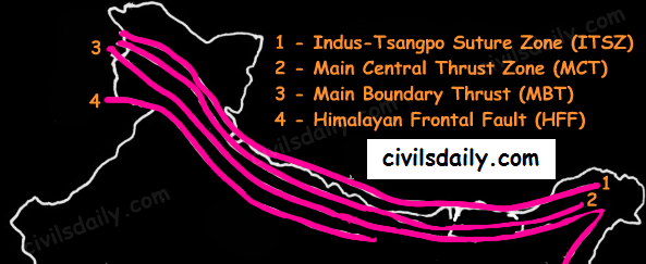
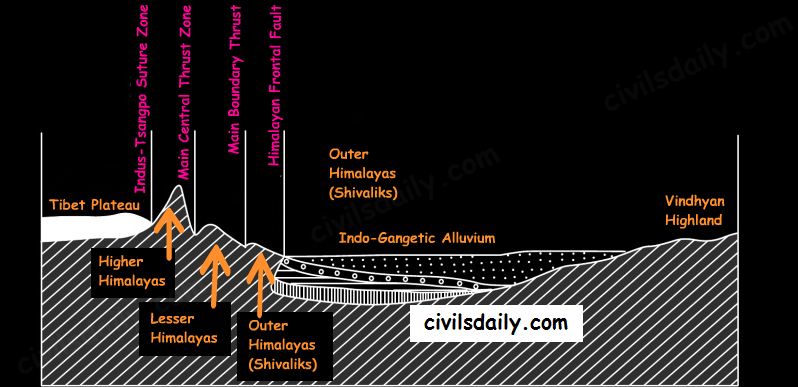
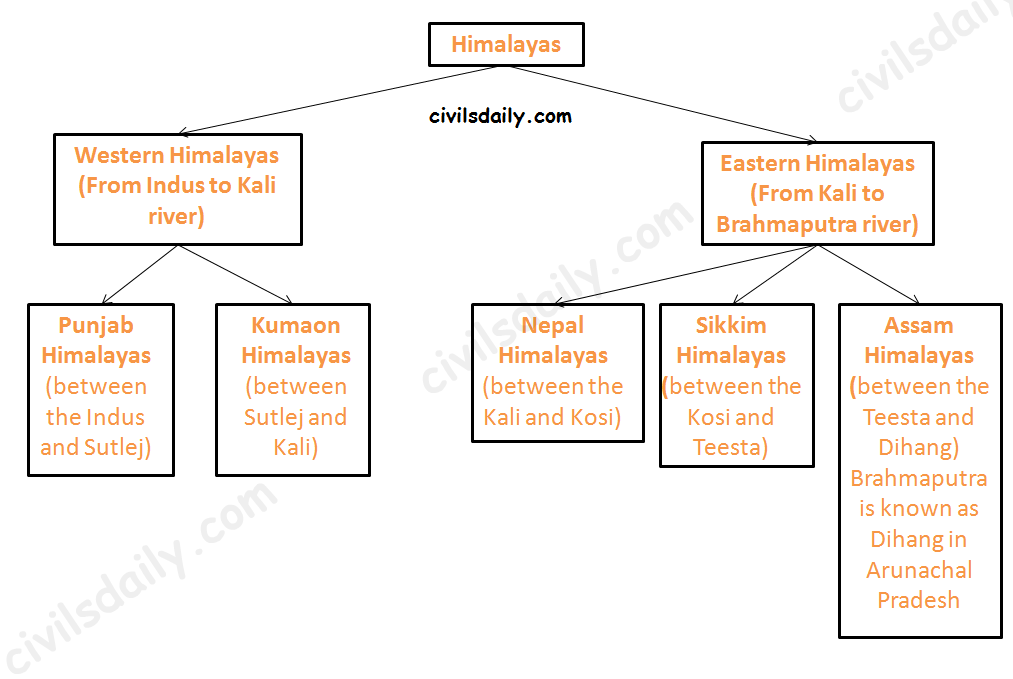
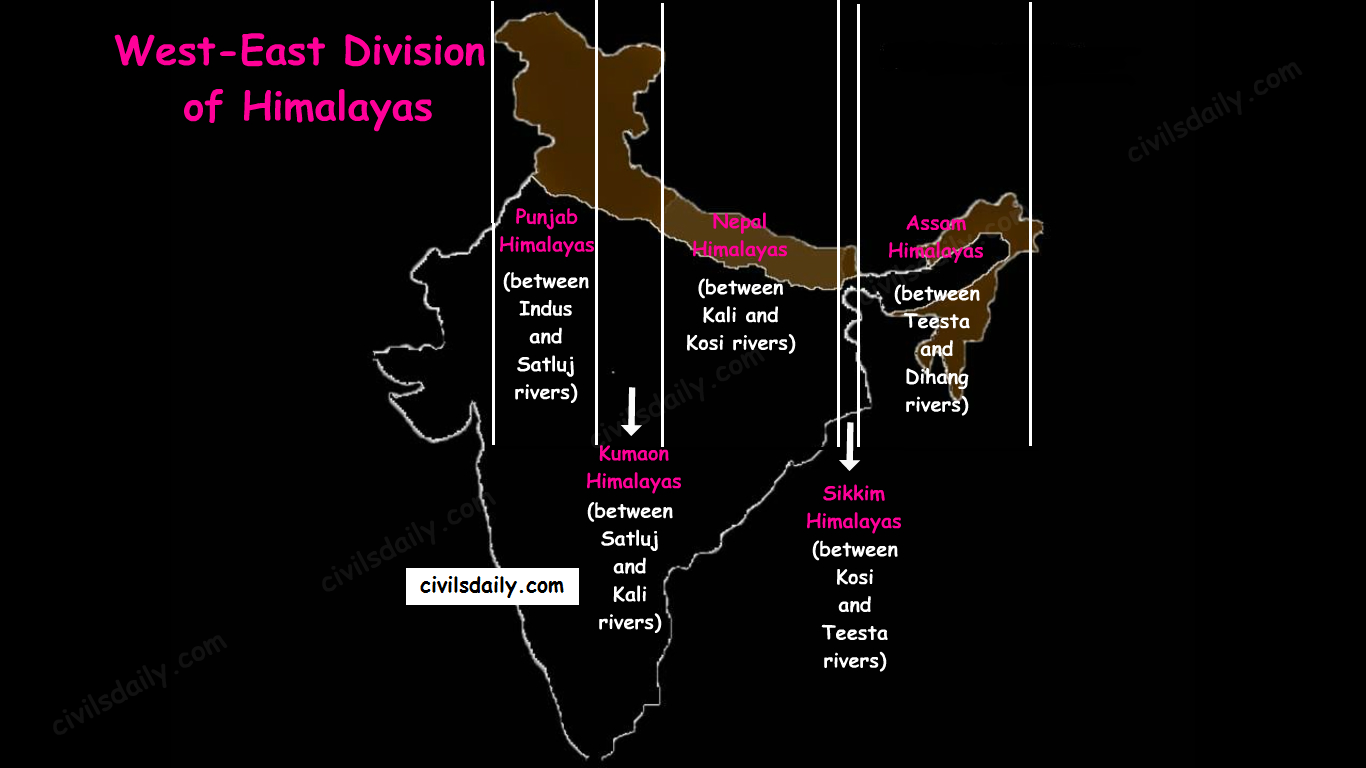
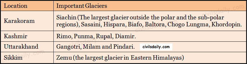
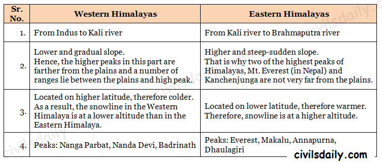

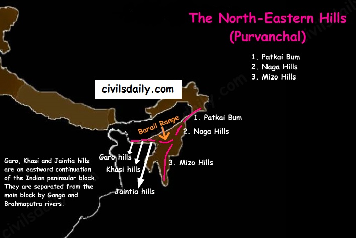
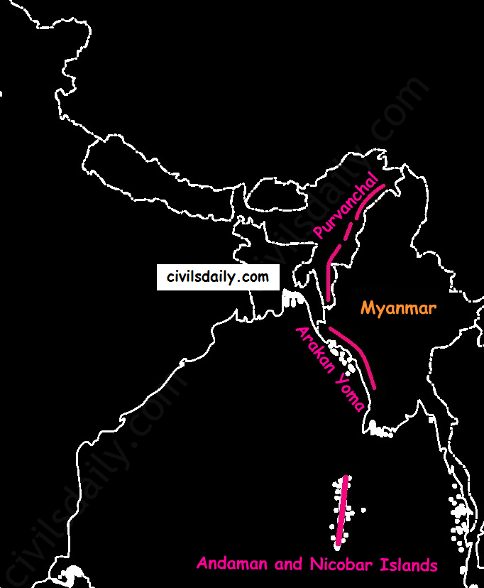
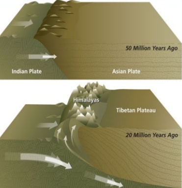
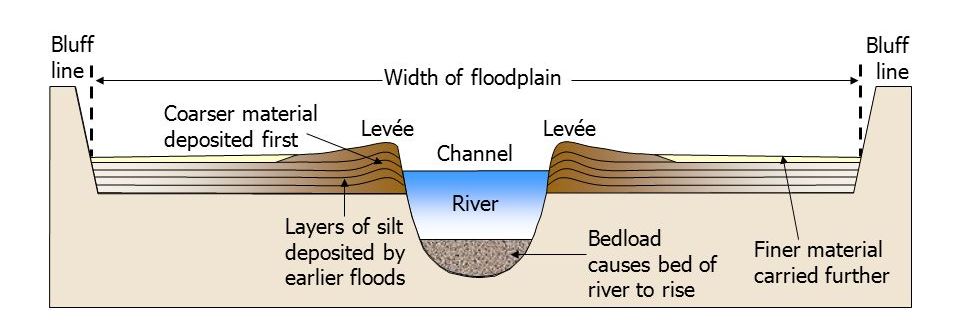
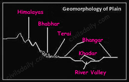
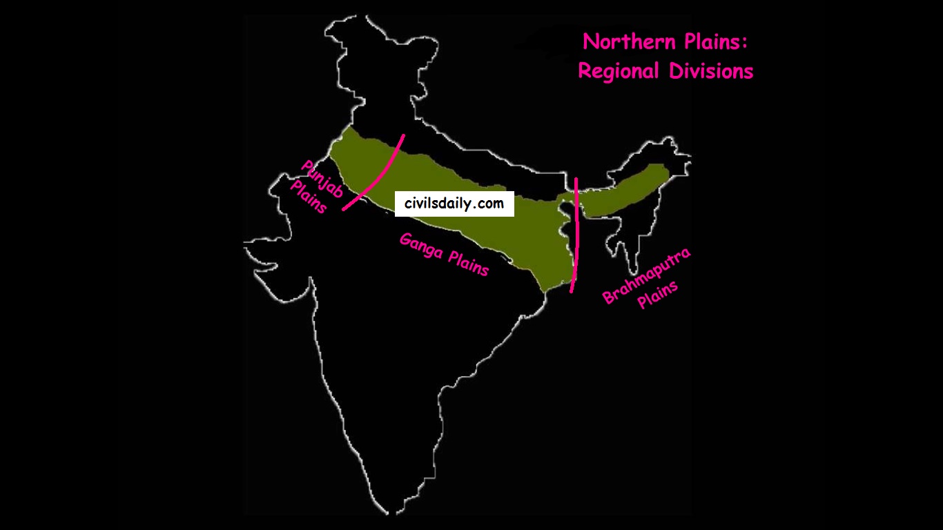
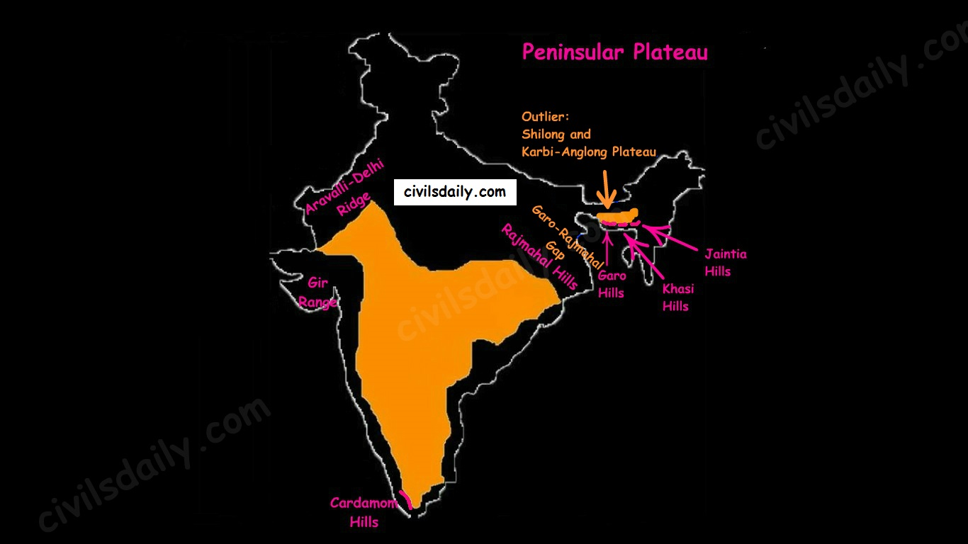
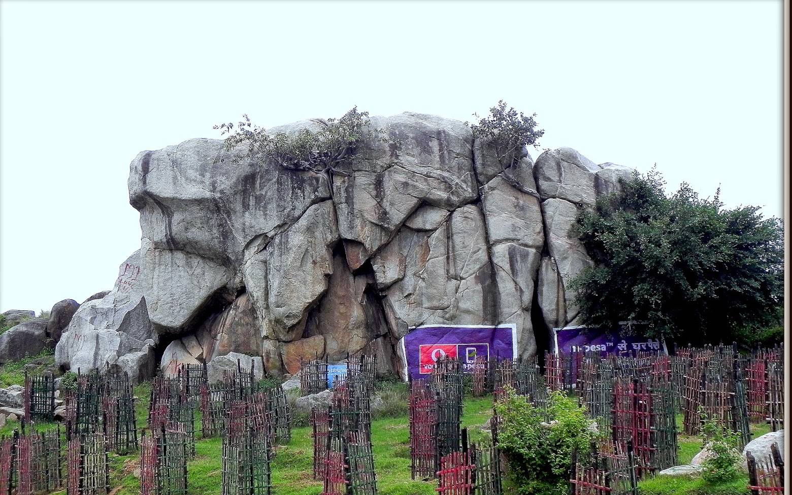
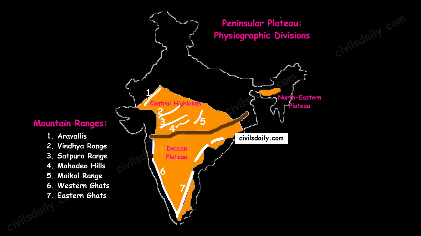
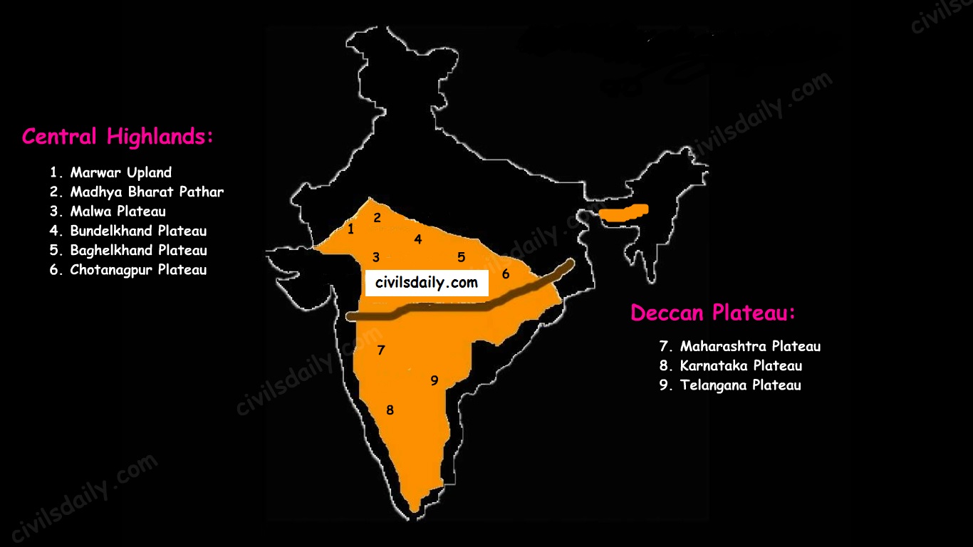
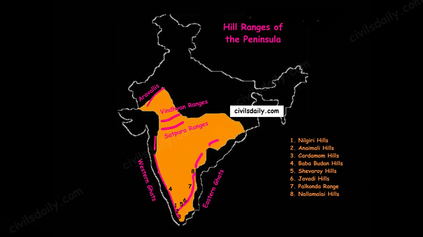
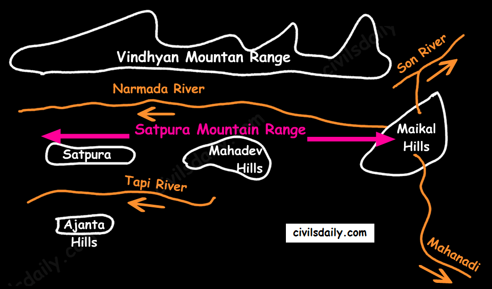
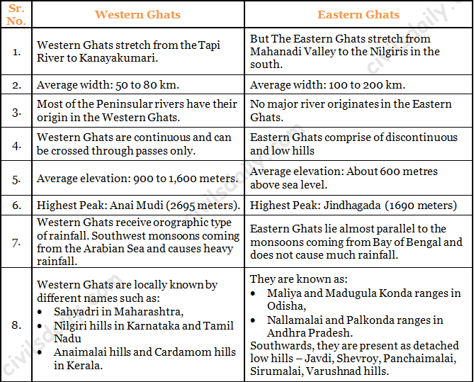
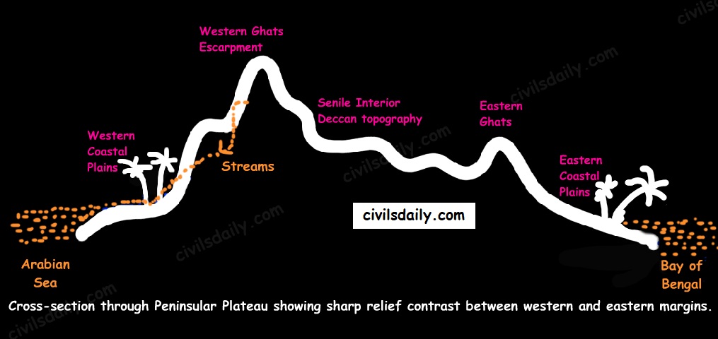
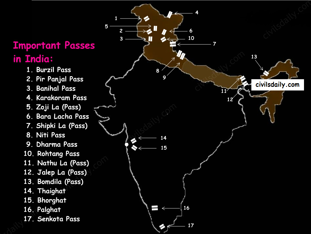
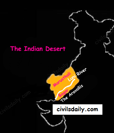
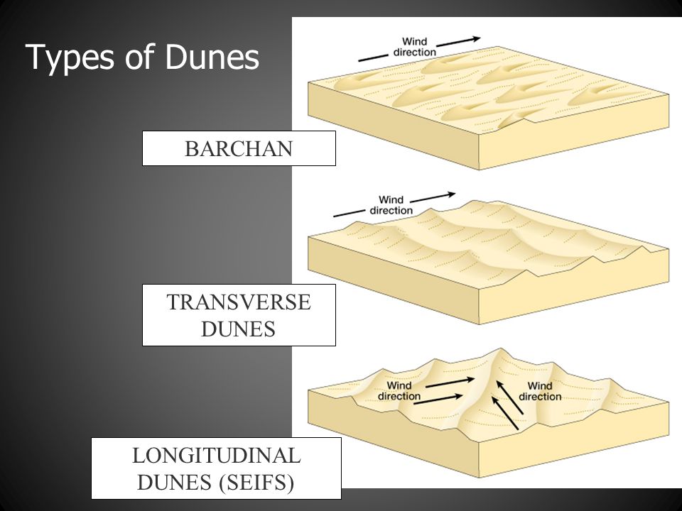
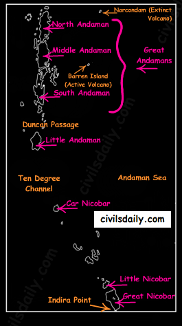
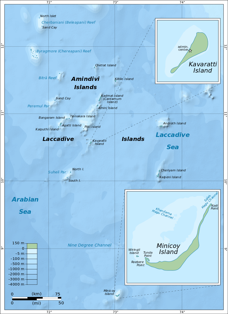


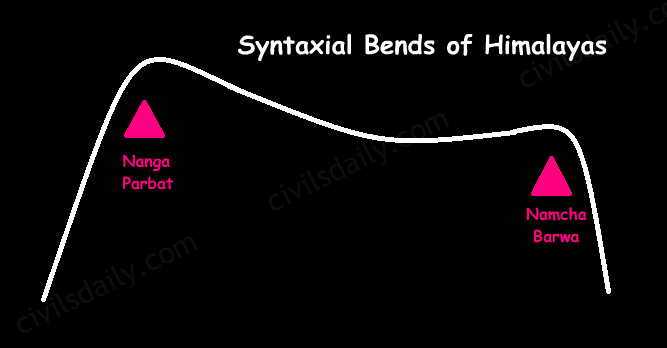
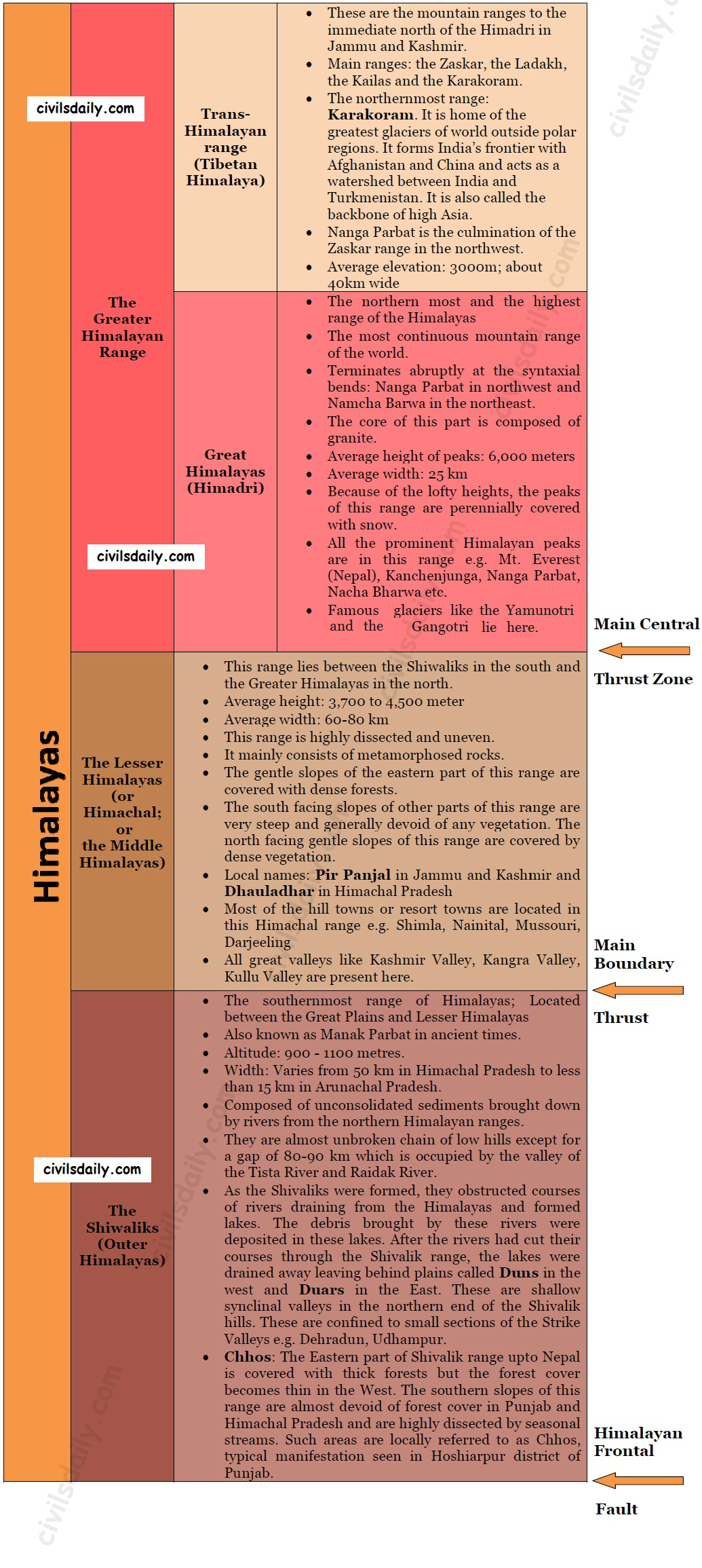
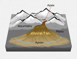
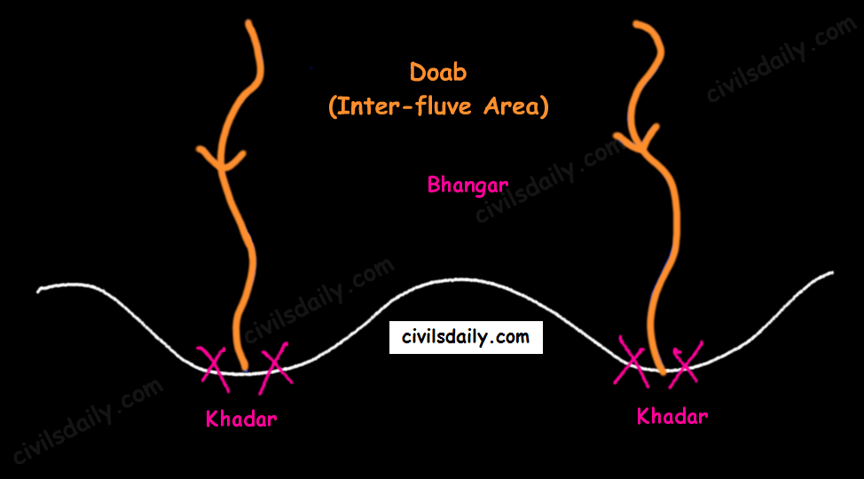