Why in the News?
The National Dam Safety Authority issued a show cause notice to the Narmada Valley Development Authority over serious safety lapses at Bargi Dam.
About Bargi Dam
- A major multipurpose dam
- Used for irrigation, drinking water supply, and hydroelectric power generation
- Jabalpur district, Madhya Pradesh
- Constructed on the Narmada River
Historical Background
- Built under the Narmada Valley Development Project
- First completed major dam among the planned series on the Narmada in Madhya Pradesh
- Became the foundation project for the state’s Narmada basin development strategy
Key Features
- 21 spillway gates: Regulate flood discharge and reservoir levels during heavy rainfall
- Bargi Diversion Project: Canal network supplying irrigation to drought prone regions
- Rani Avantibai Lodhi Sagar Project: Large scale storage and distribution system for irrigation and water supply
- Large reservoir supporting: Drinking water, Hydropower, Fisheries and Tourism and recreation
Significance
- Provides drinking water to Jabalpur and nearby districts
- Supports agriculture through assured irrigation
- Contributes to electricity generation
- Boosts regional development and eco tourism
Institutional Context
National Dam Safety Authority
- Apex body under the Dam Safety Act 2021
- Responsible for surveillance, inspection, and safety compliance of specified dams
Narmada Valley Development Authority
- Implements and manages projects under the Narmada basin
- Responsible for operation and maintenance of dams like Bargi
Prelims Pointers
- Bargi Dam is on the Narmada River
- Located in Madhya Pradesh
- Part of the Narmada Valley Development Project
- NDSA acts under the Dam Safety Act 2021
- Spillway gates are crucial for flood control
| [2016] The Narmada river flows to the west, while most other large peninsular rivers flow to the east. Why?
1. It occupies a linear rift valley
2. It flows between the Vindhyas and the Satpuras
3. The land slopes to the west from Central India
Select the correct answer using the codes given below
(a) 1 only (b) 2 and 3 (c) 1 and 3 (d) None |
Why in the News?
Ratle Hydroelectric Power Corporation Limited has sought an extension of Environmental Clearance (EC) for its 850 MW Ratle Hydroelectric Project on the Chenab River, citing delays due to litigation and COVID-19. The proposal is under appraisal by the Expert Appraisal Committee (EAC) of the Union Environment Ministry.
About the Ratle Hydroelectric Project
- Capacity: 850 MW
- Location: Kishtwar district, Jammu and Kashmir
- River basin: Indus Basin
- Type of dam: Concrete gravity dam
Environmental Clearance Timeline
- Original EC granted: December 2012
- Initial validity: Up to 2022
- Extended validity for hydropower projects: Till December 11, 2025
- Extension sought due to:
-
- Court litigations between 2014–2021
- COVID-19 disruption (April 2020 to March 2021)
Current Legal Issues
- Case pending before National Green Tribunal
- Allegations of illegal muck dumping into the Chenab
- Petition filed by residents of Thathri
- Judgment reserved in December 2025
Prelims Pointers
- Ratle project is on the Chenab River
- Falls under the Indus Basin
- EC validity can exclude court stay and COVID periods
- Joint venture led by NHPC
- Under scrutiny of NGT
| [2009] The Dul Hasti Power Station is based on which one of the following rivers?
(a) Beas
(b) Chenab
(c) Ravi
(d) Sutlej |
Why in the News?
The Hyderabad Metropolitan Development Authority (HMDA) has announced a new advanced bioremediation initiative using enzyme solutions and biochar-based Bokashi balls to clean and restore Hussainsagar Lake, which has long suffered from algal blooms, foul odour, sewage inflow, and industrial pollution.
About Hussainsagar Lake
- A 16th-century artificial lake in Hyderabad.
- Faces severe pollution due to:
- Sewage inflow
- Nutrient overload (nitrates, phosphates)
- Industrial waste
- Problems: algal blooms, foul odour, low Dissolved Oxygen (DO), high Biochemical Oxygen Demand (BOD).
What Is Bioremediation?
- Definition: Use of microorganisms, enzymes, or biological materials to break down pollutants and restore ecosystems.
- Types relevant here:
- In-situ bioremediation – treating the lake onsite without removing water.
- Bio-augmentation – adding microbial cultures to enhance degradation.
- Aerobic/oxygenation systems – boost DO to improve water quality.
New Intervention Planned by HMDA
-
-
- Enhance microbial breakdown of organic pollutants.
- Help reduce nutrient load responsible for algal blooms.
-
Bokashi Balls (with Biochar)
-
- Bokashi = fermented organic matter rich in beneficial microbes.
- Biochar:
- Carbon-rich material produced from biomass.
- Increases microbial activity, absorbs toxins, improves water clarity.
- Purpose:
- Reduce algae, odour, pathogenic bacteria.
- Increase water transparency and DO levels.
| In the context of solving pollution problems what is/are the advantage/disadvantages of bioremediation technique? (2017)
1. It is a technique for cleaning up pollution by enhancing the same biodegradation process that occurs in nature.
2. Any contaminant with heavy metals such as cadmium and lead can be readily and completely treated by bioremediation using microorganisms.
3. Genetic engineering can be used to create microorganisms specifically designed for bioremediation.
Select the correct answer using the code given below:
(a) 1 only (b) 2 and 3 only (c) 1 and 3 only (d) 1, 2 and 3 |
Why in the News?
The Umngot River, celebrated for its crystal-clear waters and tourist appeal at Dawki and Shnongpdeng, has turned murky and opaque.
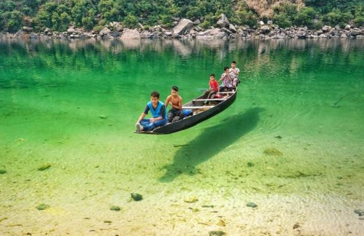
About Umngot River:
- Location: Flows through West Jaintia Hills district, Meghalaya, close to the India–Bangladesh border.
- Origin: Arises from the Jaintia Hills, traversing limestone-rich terrain that naturally filters impurities and maintains clarity.
- Distinct Appearance: Known for its crystal-clear waters that create the illusion of boats floating on air, earning it global recognition.
- Length & Course: Flows southward to Dawki town, where it merges with Bangladesh’s Piyain River.
- Ecological Features: Possesses high dissolved oxygen levels, preventing algal growth and supporting diverse aquatic biodiversity.
- Tourism Hub: Popular at Dawki and Shnongpdeng for boating, fishing, camping, and eco-tourism, drawing thousands of visitors annually.
- Infrastructure Landmark: The Dawki Suspension Bridge (1932) is a heritage structure spanning the river and serving as a trade route link.
- Economic Role: Sustains cross-border trade, local fishing, and tourism-driven livelihoods vital to Meghalaya’s rural economy.
- Cultural Boundary: Serves as a natural divider between Ri Pnar (Jaintia Hills) and Hima Khyrim (Khasi Hills).
Cause of Discoloration:
- Primary Cause: Linked to Shillong–Dawki road-widening project upgrading it to a two-lane highway with a 400 m bridge at Dawki.
- Pollution Source: Hill-cutting, excavation, and soil dumping along sites near Umtyngar and Dawki caused heavy sediment runoff.
- Inspection Findings: The Meghalaya State Pollution Control Board (MSPCB) detected uncontained debris and sliding soil entering the river, reducing water transparency.
| [UPSC 2021] Consider the following rivers:
1. Brahmani 2. Nagavali 3. Subarnarekha 4. Vamsadhara
Which of the above rise from the Eastern Ghats?
Options: (a) 1 and 2 (b) 2 and 4* (c) 3 and 4 (d) 1 and 3 |
Why in the News?
The Naying Hydroelectric Project (1000 MW), proposed on the Siyom (Yomgo) River in Shi-Yomi district, Arunachal Pradesh, represents a major addition to India’s clean energy expansion under the Decade of Hydro Power (2025–35).
About Siyom (Yomgo) River:
- Geography: A right-bank tributary of the Brahmaputra, flowing entirely within Arunachal Pradesh.
- Origin & Course: Arises in West Siang, travels ~170 km, and joins the Brahmaputra near Assam.
- Ecology: Basin supports rich biodiversity, agro-pastoral livelihoods, and lies within the Eastern Himalaya Biodiversity Hotspot.
- Protected Areas: Mouling National Park lies on its eastern bank, part of the Dibang–Siang biosphere landscape.
- Hydrological Role: Ensures irrigation, microclimate regulation, and provides run-of-the-river potential for clean energy, though demanding careful ecosystem balance.
|
About Naying Hydroelectric Project:
- Overview: A proposed 1,000 MW (4×250 MW) run-of-the-river project located in Shi-Yomi district, Arunachal Pradesh.
- Developers: Jointly undertaken by North Eastern Electric Power Corporation (NEEPCO) and Arunachal Pradesh Hydropower Corporation Ltd (APHCL).
- Design & Output: Features a concrete dam, underground powerhouse, and diversion tunnels, expected to generate 4,966.77 GWh annually.
- Regulatory Approval: Received Central Electricity Authority (CEA) concurrence in 2013; progress slowed by environmental and social concerns.
- Public Consultation: Environmental hearing scheduled for 12 November 2025 at Yapik Community Hall to assess ecological and community impacts.
- Timeline: Construction targeted to start by 2028, with commissioning by 2032.
- Policy Context: Forms part of the state’s Decade of Hydro Power (2025–2035), aiming for 19 GW capacity addition to support India’s net-zero goals.
- Regional Linkages: Among five key hydel projects in the region – Heo (240 MW), Hirong (500 MW), Tato-I (186 MW), and Tato-II (700 MW).
| [UPSC 2022] Consider the following pairs:
Reservoirs – States
1. Ghataprabha — Telangana
2. Gandhi Sagar — Madhya Pradesh
3. Indira Sagar — Andhra Pradesh
4. Maithon —Chhattisgarh
Options:
(a) Only one pair (b) Only two pairs (c) Only three pairs (d) All four pairs” |
- Why in the News?
Karnataka govt. has approved Upper Krishna Project Phase-III to raise Almatti dam height, while Maharashtra warned of moving the Supreme Court against it.
Why is Maharashtra opposing it?
- Fears submergence of villages and agricultural land in its territory if water levels rise further.
- Worries about reduced water availability downstream, affecting its irrigation and drinking water projects.
|
About Almatti Dam:
- Overview: It is a hydroelectric and irrigation project built on the Krishna River in North Karnataka.
- Completion: July 2005, as part of the Upper Krishna Irrigation Project (UKP).
- Dimensions: Height 52.5 m, length 3.5 km.
- Power Generation: A 290 MW station using vertical Kaplan turbines (five of 55 MW and one of 15 MW).
- Two separate powerhouses: Almatti I and II generate power before releasing water into the Narayanpur Reservoir.
- Functions: Provides irrigation, potable water, hydroelectric power, and helps in flood management.
Back2Basics: Krishna River

- Origin: Near Mahabaleshwar (Satara, Maharashtra), in the Western Ghats.
- Length: ~1,300 km, second-longest river in peninsular India after Godavari.
- Course: Flows through Maharashtra (303 km), Karnataka (480 km), Telangana, and Andhra Pradesh, before emptying into the Bay of Bengal.
- Major Tributaries:
- Right-bank: Ghatprabha, Malprabha, Tungabhadra.
- Left-bank: Bhima, Musi, Munneru.
- Hydropower & Irrigation Projects: Includes Koyna, Tungabhadra, Srisailam, Nagarjuna Sagar, Almatti, Narayanpur, Bhadra.
|
| [UPSC 2005] The Almatti Dam is on the river:
Options: (a) Godavari (b) Cauvery (c) Krishna* (d) Mahanadi |
Why in the News?
After suspending the Indus Waters Treaty, India is asserting water control in J&K by reviving the Sawalkote Hydroelectric Project — the UT’s largest planned hydro project.
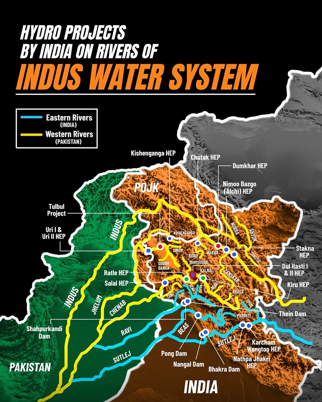
About Sawalkote Hydro Project:
- Location: Ramban and Udhampur districts, Jammu and Kashmir.
- River: Built on the Chenab River (a western river under the Indus Waters Treaty).
- Agency: Implemented by National Hydroelectric Power Corporation.
- History: Proposed in the 1960s; delayed due to Pakistan’s objections, environmental issues, and red tape. Revived after India suspended the Indus Waters Treaty post the April 2025 Pahalgam terror attack.
- Status (2025): Forest clearance granted; tenders floated on 29 July 2025; declared a project of national importance.
- Timeline: 96 months post-clearance; expected commissioning by or after 2032.
Key Features:
- Type: Run-of-the-river (utilizes the natural flow and elevation drop of a river) hydroelectric project.
- Capacity: 1,856 Megawatts (8 × 225 MW + 1 × 56 MW).
- Dam: 192.5 m high, roller-compacted concrete gravity dam; reservoir holds 550 million cubic meters.
- Powerhouse: Underground, with Francis turbines.
- Cost: ₹22,704.8 crore (~2.6 billion United States Dollars).
| [UPSC 2009] Gandhi Sagar Dam is a part of which one of the following?
Options: (a) Chambal Project * (b) Kosi Project (c) Damodar Valley Project (d) Bhakra Nangal Project |