💥Crack UPSC In 1st Attempt | Admission Open | Ultimate Assessment Program 2027/2028

Subject: Bilateral Relations

1. Major World Events
2. India’s Interests in neighbourhood
3. Effects of our Policies

  • Forum for India Pacific Islands Cooperation (FIPIC)

    pacific

    Central Idea: The third summit of Forum for India Pacific Islands Cooperation (FIPIC) was recently held at Port Moresby in Papua New Guinea. It was attended by PM Modi.

    What is FIPIC?

    • The FIPIC is an intergovernmental forum that facilitates cooperation and dialogue between India and the Pacific island countries (PIC).
    • It was established by India in 2014 as a platform to enhance engagement and strengthen ties with the countries of the Pacific region.
    • FIPIC serves as a mechanism for mutual collaboration, addressing shared challenges, and promoting development cooperation between India and its Pacific island partners.

    Members of FIPIC:

    • FIPIC consists of 14 member-countries.
    • They are- Fiji, Cook Islands, Kiribati, Marshall Islands, Micronesia, Nauru, Niue, Palau, Papua New Guinea, Samoa, Solomon Islands, Tonga, Tuvalu, and Vanuatu.

    History of FIPIC

    • The establishment of FIPIC reflects India’s commitment to deepening its engagement with the Pacific island nations.
    • The inaugural FIPIC summit was held in November 2014 in Suva, Fiji, where India and the Pacific island countries came together to discuss bilateral and multilateral cooperation.
    • The summit marked a significant milestone in India’s efforts to strengthen relations with the Pacific island states and promote inclusive development in the region.

    Key highlights of the Summit

    (1) Imbibing perception change

    • During the FIPIC-3 summit held in Port Moresby, PM Modi emphasized the importance of recognizing the small island nations of the Pacific Ocean as “large ocean states.”
    • PM reiterated India’s commitment to supporting the development goals of the Pacific island states.

    (2) Advancing development goals

    • India expressed unwavering dedication to supporting Pacific island states in various ways.
    • Acknowledged challenges such as climate change, natural calamities, and disruptions in food and fuel supply chains.
    • India has been a reliable supplier of essential items, including vaccines, medicines, wheat, and sugar.

    (3) Voices to lead Global South

    • Prime Minister James Marape of Papua New Guinea urged India to serve as an advocate for the Global South.
    • Requested India’s representation in key global forums like the G-7 and G-20.

    Why does India need PIC?

    • Geopolitical Significance: Strengthening ties in Indo-Pacific to bolster regional influence, promote stability, and shape regional dynamics.
    • Maritime Trade Routes: Securing access to vital sea-lanes, ensuring smooth trade flow, and protecting maritime interests.
    • Resources: Expanding access to valuable resources such as minerals, hydrocarbons, and fisheries for economic growth and energy security.
    • Economic Opportunities: Exploring untapped markets, attracting investments, and fostering trade partnerships for mutual economic benefits.
    • Climate Change and Disaster Management: Collaborating on climate resilience strategies, sharing expertise in disaster management, and supporting sustainable development.
    • Diplomatic Relations: Establishing strategic alliances, enhancing multilateral cooperation, and strengthening India’s presence in the Pacific region.
    • Indian Diaspora: Supporting and engaging with the Indian diaspora, promoting cultural ties, and leveraging their contributions for bilateral cooperation and understanding.

    Conclusion

    • The FIPIC-3 summit provided a platform for India and Pacific island nations to deepen cooperation and address shared challenges.
    • India’s commitment to supporting development goals and its role as a reliable supplier underscores its dedication to the Pacific island states.
    • India’s active engagement in global forums and advocacy for the Global South aims to amplify voices and advance interests.
    • The summit signifies a strengthened partnership, fostering mutual growth and shared progress.


    Get an IAS/IPS ranker as your personal mentor for UPSC 2024

  • CPEC to be extended to Afghanistan

    cpec

    Central Idea: Pakistan, China and Afghanistan have agreed to extending the Beijing-backed China-Pakistan Economic Corridor (CPEC) to Afghanistan to fully harness the country’s potential as a hub for regional connectivity.

    What is CPEC?

    • The CPEC, one of the most ambitious components of Beijing’s Belt and Road Initiative (BRI), was announced to great fanfare in 2015.
    • CPEC is a collection of infrastructure projects that are under construction throughout Pakistan beginning in 2013.
    • Originally valued at $47 billion, the value of CPEC projects is worth $62 billion as of 2020.
    • It is intended to rapidly upgrade Pakistan’s required infrastructure and strengthen its economy by the construction of modern transportation networks, numerous energy projects, and SEZs.
    • On 13 November 2016, CPEC became partly operational when Chinese cargo was transported overland to Gwadar Port for onward maritime shipment to Africa and West Asia.

    India’s reservation against CPEC

    Ans. Sovereignty breach

    • India which shares tense relations with Pakistan, objects to the CPEC project as upgrade works to the Karakoram Highway are taking place in Gilgit-Baltistan.
    • This is the territory illicitly occupied by Pakistan in 1947-48.
    • During the visit of Indian PM Modi to China in 2015, the Indian FM, Sushma Swaraj reportedly told the Chinese.
    • India did not object to the Chinese construction of the Karakoram Highway which was built between 1959 and 1979.

    Why CPEC?

    • Economic push for Pak: CPEC has consistently been held up as a “gamechanger” for Pakistan’s economy.
    • Debt trap diplomacy: At the same time, China is the only country that is heavily investing in Pakistan.

    Progress status

    • Slow pace: Gwadar, despite being the epicenter of multibillion-dollar projects, lacks basic necessities like reliable access to water and electricity, let alone other facilities.
    • At standstill: But the road to completion has proved long and winding. Reports indicate that the pace of CPEC projects has been slowing down in Pakistan in recent years.
    • Baloch freedom movement: This is another impediment to the stalled project where Chinese officials are targeted and killed.
    • Consistent security threat: China is also seeking to deploy its Army in the CPEC projects, to which Pakistan has contested.


    Get an IAS/IPS ranker as your personal mentor for UPSC 2024 | Schedule your FREE session and get the Prelims prep Toolkit!

  • ASEAN-India maritime exercise in South China Sea

    south china sea asean

    Central idea: The article highlights India’s increasing military cooperation with ASEAN countries, with a special emphasis on the upcoming ASEAN-India Maritime Exercise (AIME) in the South China Sea.

    ASEAN-India Maritime Exercise

    • The first ASEAN-India Maritime Exercise (AIME) is set to commence on May 2, 2023, with war games to be held in the South China Sea.
    • INS Satpura and INS Delhi will participate in the exercise.
    • The exercise is divided into two phases: ‘Harbour Phase’ and ‘Sea Phase.’
    • The exercise is aimed at fostering close cooperation and conducting seamless operations in the maritime domain between the Indian Navy and ASEAN navies.

    About ASEAN (Association of Southeast Asian Nations)

    Details
    Members Brunei Darussalam, Cambodia, Indonesia, Laos, Malaysia, Myanmar, Philippines, Singapore, Thailand, Vietnam
    Formation August 8, 1967
    Headquarters Jakarta, Indonesia
    Purpose To promote economic growth, social progress, and cultural development
    Economic integration ASEAN Free Trade Area (AFTA) and ASEAN Economic Community (AEC)
    Political cooperation ASEAN Regional Forum (ARF) and ASEAN Defense Ministers Meeting (ADMM)
    Cultural cooperation ASEAN Socio-Cultural Community (ASCC)
    Relationship with India Strategic partnership, trade, and investment


    Why such exercise?

    • Defying territorial claims: The South China Sea is a critical waterway that connects the Indian Ocean with the Pacific Ocean, and it is also a contested region where multiple countries have territorial claims.
    • Support freedom of navigation: Conducting exercises in this region allows India to demonstrate its commitment to maintaining freedom of navigation and upholding international maritime laws.
    • Indo-Pacific Strategy: India’s growing strategic ties with ASEAN are part of its broader Indo-Pacific strategy, which seeks to promote a rules-based order and ensure stability in the region.
    • Counterbalancing China: As China’s influence in the Indo-Pacific grows, India sees ASEAN as a key partner in balancing China’s assertiveness and promoting regional stability.

    India’s stakes in South China Sea

    The South China Sea plays a critical role in India’s security and well-being as-

    • Global common: The SCS is not China’s sea, but a global common.
    • Unimpeded navigation: It has been an important sea-lane of communication for centuries, and passage has been unimpeded. Indians have sailed these waters for well over 1,500 years with a continuous trading presence.
    • Global trade chokepoint: Nearly $200 billion of India’s trade passes through the South China Sea, and thousands of Indian citizens study, work and invest in ASEAN, China, Japan and the Republic of Korea.

    Key significance: India’s Responsiveness to ASEAN

    India needs to be responsive to ASEAN’s expectations.

    • Meeting ASEAN’s aspirations: While strategic partnerships and high-level engagements are important, ASEAN expects longer-lasting buy-ins by India in their future.
    • History of lesser importance given by India: ASEAN has taken the initiative time and again to involve India in Indo-Pacific affairs, even though India’s current level of trade or investment with ASEAN does not make a compelling argument.
    • Broader perception of India as key partner: ASEAN has deliberately taken a longer-term view, given the importance of regional arrangements for economic recovery and rejuvenation.


    Back2Basics:  South China Sea Dispute

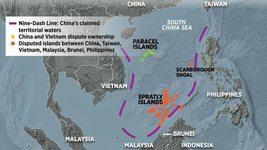
    • It is a dispute over territory and sovereignty over ocean areas, and the Paracels and the Spratlys – two island chains claimed in whole or in part by a number of countries.
    • China, Vietnam, the Philippines, Taiwan, Malaysia, and Brunei all have competing claims.
    • Alongside the fully-fledged islands, there are dozens of rocky outcrops, atolls, sandbanks, and reefs, such as the Scarborough Shoal.
    • China claims by far the largest portion of territory – an area defined by the “nine-dash line” which stretches hundreds of miles south and east from its most southerly province of Hainan.
    • Beijing says its right to the area goes back centuries to when the Paracel and Spratly island chains were regarded as integral parts of the Chinese nation, and in 1947 it issued a map detailing its claims.
    • It showed the two island groups falling entirely within its territory. Those claims are mirrored by Taiwan.


    Get an IAS/IPS ranker as your personal mentor for UPSC 2024 | Schedule your FREE session and get the Prelims prep Toolkit!

  • Operation Kaveri to evacuate stranded citizens from Sudan

    kaveri

    India has launched “Operation Kaveri” to evacuate its citizens from war-torn Sudan.

    What is Operation Kaveri?

    • It is the recent series of evacuations held by India over the last few years to rescue its nationals in crisis-hit countries. India rescued its nationals last year from war-hit Ukraine and Afghanistan.
    • The operation was launched in response to the conflict and breakdown of essential services in Sudan that had brought the country to a standstill.
    • India has positioned two transport aircraft of the IAF in the Saudi Arabian city of Jeddah and a naval ship at a key port in Sudan as part of its contingency plans to evacuate its stranded nationals.

    Behind the name ‘Kaveri’

    • The choice of naming this operation as ‘Operation Kaveri’ has a lot of significance.
    • Kaveri is one of the major Indian rivers flowing through the southern states of Karnataka and Tamil Nadu.
    • The river is sacred to the people of the region and is worshipped as the Goddess Kaveriamma (mother Kaveri).
    • Rivers reach their destination irrespective of barriers. It’s like a mother who will ensure she will bring her children back to safety.

    About Sudan

    kaveri sudan

    • Sudan is a country located in North Africa, bordered by Egypt to the north, Libya to the northwest, Chad to the west, the Central African Republic to the southwest, South Sudan to the south, Ethiopia to the southeast, and Eritrea to the east.
    • It is the third-largest country in Africa and has a diverse population of around 43 million people.
    • According to the World Bank, around 46% of the population lives below the poverty line, and many Sudanese people struggle to access basic services such as healthcare, education, and clean water.

    What is the crisis all about?

    • Sudan is facing a crisis due to fighting between two rival military factions.
    • The conflict involves the Sudanese army and the paramilitary Rapid Support Forces (RSF).
    • The fighting began in April 2022 after tensions rose following the coup that saw the two factions topple a civilian government in October 2021.
    • The conflict began when an internationally-backed plan to launch a new transition with civilian parties was floated.
    • Under the plan, both the army and the RSF had to cede power, but two issues were contentious: the formal placing of the army under civilian oversight and the timetable for the RSF to be integrated into the regular armed forces.

    Global Implications of the Conflict

    • The volatile region, which borders the Red Sea, the Sahel, and the Horn of Africa, could be destabilized if the fighting continues.
    • The conflict in Sudan has the potential to cause a refugee crisis, with people fleeing the country to escape the violence and instability.


    Get an IAS/IPS ranker as your personal mentor for UPSC 2024 | Schedule your FREE session and get Prelims prep Toolkit!

  • India signs MoU with World Food Programme for sending wheat to Afghanistan

    India signed an MoU with the World Food Programme (WFP) to send 10,000 metric tonnes of wheat to Afghanistan.

    Reason: Utilizing WFP supply chain

    • The MoU signed between India and the World Food Programme (WFP) paves the way for sending 10,000 metric tonnes of wheat for the people of Afghanistan.
    • The WFP has a massive supply chain and logistics infrastructure in Afghanistan that could help in ensuring that the food supply reaches those who need it the most and no one is excluded.
    • The MoU also ensures that the assistance is coordinated and delivered in an effective and efficient manner, and that it reaches the most vulnerable sections of the Afghan population.

    What is World Food Programme (WFP)?

    • The WFP is a humanitarian organization that is part of the United Nations system.
    • It was established in 1961 and has its headquarters in Rome, Italy.
    • The WFP is the world’s largest humanitarian agency focused on combating hunger and promoting food security.

    Scope of Operations

    • The WFP operates in more than 80 countries, delivering food assistance to people in need.
    • WFP programs reach over 97 million people each year, including children, pregnant and nursing women, and people affected by emergencies, such as conflict or natural disasters.
    • It provides a range of food assistance, including in-kind food assistance, cash and voucher-based transfers, and specialized nutritious foods.

    Funding and Support

    • The WFP is funded entirely by voluntary contributions from governments, companies, and individuals.
    • The organization works closely with donors to ensure that funding is used effectively and efficiently, and to ensure that it is directed to the areas and programs where it is needed most.

    Governance and Structure

    • The WFP is governed by an Executive Board, which is composed of 36 member states that are elected to three-year terms.
    • The Executive Board provides oversight and strategic direction to the organization, and approves the WFP’s programs and budgets.
    • The WFP is headed by an Executive Director, who is appointed by the Secretary-General of the United Nations.
    • The organization has more than 17,000 staff worldwide, including professionals in fields such as logistics, nutrition, and food security.

    Impact and Achievements

    • Over the years, the WFP has made significant contributions to addressing hunger and promoting food security worldwide.
    • The organization has responded to numerous emergencies, providing food assistance to millions of people affected by conflict, natural disasters, and other crises.
    • The WFP has also supported programs that help people access the food they need to lead healthy, active lives, and that promote sustainable agriculture and development.
    • The WFP has been recognized for its efforts, receiving the Nobel Peace Prize in 2020 in recognition of its contributions to combatting hunger and promoting peace.


  • China issues ‘official’ names for some places in Arunachal Pradesh

    china

    Central idea: The Chinese government has announced it would “standardize” the names of 11 places in Arunachal Pradesh.

    MEA clarification

    • The Ministry of External Affairs has dismissed the Chinese “invention”.
    • Arunachal Pradesh has always been, and will always be, an integral part of India, said MEA.

    Why is China giving names to places that are in India?

    • China claims some 90,000 sq km of Arunachal Pradesh as its territory.
    • It calls the area “Zangnan” in the Chinese language and makes repeated references to “South Tibet”.
    • Chinese maps show Arunachal Pradesh as part of China, and sometimes parenthetically refer to it as “so-called Arunachal Pradesh”.
    • China makes periodic efforts to underline this unilateral claim to Indian territory.
    • Giving Chinese names to places in Arunachal Pradesh is part of that effort.

    Earlier unilateral renaming

    • This is the third lot of “standardized” names of places in Arunachal Pradesh that China has announced.
    • Earlier in 2017, it had issued “official” Chinese names for six places spanning the breadth of Arunachal Pradesh

    What is China’s argument for claiming these areas?

    • The PRC disputes the legal status of the McMahon Line, the official boundary under the ‘Convention between Great Britain, China, and Tibet’ — of 1914 (Simla Convention).
    • China was represented at the Simla Convention by a plenipotentiary of the Republic of China, which had been declared in 1912 after the Qing dynasty was overthrown.
    • The present communist government came to power only in 1949, when the People’s Republic was proclaimed.
    • The Chinese representative did not consent to the Simla Convention, saying Tibet had no independent authority to enter into international agreements.

    What is the McMohan Line?

    • The McMohan Line, named after Henry McMahon, the chief British negotiator at Shimla, was drawn from the eastern border of Bhutan to the Isu Razi pass on the China-Myanmar border.
    • China claims territory to the south of the McMahon Line, lying in Arunachal Pradesh.
    • China also bases its claims on the historical ties that have existed between the monasteries in Tawang and Lhasa.

    Intention behind these renamings

    • This renaming is a part of the Chinese strategy to assert its territorial claims over Indian territory.
    • As part of this strategy, China routinely issues statements of outrage whenever an Indian dignitary visits Arunachal Pradesh.
    • Beijing keeps harping on its “consistent” and “clear” position that the Indian possession of Arunachal Pradesh.
    • These claims have been firmly established and recognized by the world, as “illegal”.

    Arunachal not all-alone

    • Laying aggressive claims to territories on the basis of alleged historical injustices done to China is a part of Beijing’s foreign policy playbook.
    • The claim on Taiwan is one such example, as are the consistent efforts to change the “facts on the ground” in several disputed islands in the South China Sea.
    • The aggression is at all times backed in overt and covert ways by the use of China’s economic and military muscle.


  • UK to join Asia-Pacific Trade Treaty

    trade

    UK has agreed to join the Comprehensive and Progressive Agreement for Trans-Pacific Partnership (CPTPP), a trade pact based around the Pacific Rim, as it seeks to build ties around the world after leaving the European Union.

    Comprehensive and Progressive Agreement for Trans-Pacific Partnership (CPTPP)

    • CPTPP is a free trade agreement (FTA) that was agreed in 2018 between 11 countries – Australia, Brunei, Canada, Chile, Japan, Malaysia, Mexico, New Zealand, Peru, Singapore and Vietnam.
    • Britain will become the 12th member, and the first to join since the partnership since its inception.
    • The agreement was originally proposed as the Trans-Pacific Partnership (TPP) in 2005, with the goal of creating a free trade area that would cover 12 countries, including the US.
    • However, the US withdrew from the agreement in 2017, prompting the remaining 11 countries to renegotiate the deal and create the CPTPP.

    Economic prospects

    • CPTPP countries approximately has a combined GDP of 11 trillion pounds ($13.6 trillion) once Britain joins, or 15% of global GDP with UK membership.
    • It does not have a single market for goods or services, and so regulatory harmonisation is not required, unlike the European Union, whose trading orbit Britain left at the end of 2020.

    Key trade objectives of CPTPP

    • The CPTPP is designed to reduce tariffs and promote economic integration among its members.
    • It aims to eliminate tariffs on more than 95% of goods traded between member countries, and to provide greater market access for services and investment.
    • The agreement also includes provisions on intellectual property, labor, and environmental standards.

    How much does Britain trade with CPTPP?

    • British exports to CPTPP countries were worth 60.5 billion pounds in the twelve months to end-Sept. 2022.
    • Membership of the grouping will add another 1.8 billion pounds each year in the long run, and possibly more if other countries join.

    Key benefits to be reaped by UK

    • Exporters could benefit from CPTPP membership even when trading with countries where there is a bilateral FTA.
    • To benefit from preferential tariffs, exporters must demonstrate a product as a sufficient proportion of “locally” sourced parts.
    • Rules of origin under rolled-over post-Brexit free trade agreements with Japan, Mexico and Canada, for instance, allow exporters to count EU inputs as “local”.
    • However, under CPTPP, inputs from CPTPP members can usually be considered local, giving exporters another option if it is beneficial.

    Geopolitical considerations: China Factor

    • While the long-term benefit for Britain’s economy is set to be modest, Britain has other reasons for joining the bloc.
    • UK will get a veto on whether China joins the treaty. Beijing had applied to become a member of the bloc in September 2021.


  • What is the McMahon Line?

    McMahon

    Central idea: Republican and Democrat senators introduced a resolution in US Congress reiterating that the US recognises the McMahon Line as the international boundary between China and India in Arunachal Pradesh.

    Significance of such move

    • This resolute confirms US (both ruling and opposition) stand with India at a time when China poses a threat to the Free and Open Indo-Pacific.
    • The resolution reaffirms India’s position that Arunachal Pradesh, which China calls ‘South Tibet’, is an integral part of India.

    What is the McMahon Line?

    • The McMahon Line serves as the de facto boundary between China and India in the Eastern Sector and represents the boundary between Arunachal Pradesh and Tibet.
    • China disputes the boundary and claims the state of Arunachal Pradesh as part of the Tibetan Autonomous Region (TAR).

    Under what circumstances was the McMahon Line drawn?

    • The McMahon Line was drawn during the Simla Convention of 1914, officially described as the Convention between Great Britain, China, and Tibet.
    • The British led an expedition into Tibet and signed the Convention of Lhasa in 1904, alarmed at the growing Russian influence in the region.
    • China invaded at the same time, taking control of the southeastern Kham region and pushing British officials to advocate extending British jurisdiction into the tribal territory.
    • The convention attempted to settle the question of Tibet’s sovereignty and avoid further territorial disputes in the region.

    What happened at the Simla Convention of 1913-14?

    • The Tibetan government in Lhasa was represented by its plenipotentiary Paljor Dorje Shatra, and Britain by Sir Arthur Henry McMahon, foreign secretary of British India at Delhi.
    • The Chinese plenipotentiary was Ivan Chen.
    • The treaty divided the Buddhist region into “Outer Tibet” and “Inner Tibet” and determined the border between China proper and Tibet as well as Tibet and British India.
    • The final convention was only signed by McMahon on behalf of the British government and Shatra on behalf of Lhasa.
    • Ivan Chen did not consent to the convention, arguing that Tibet had no independent authority to enter into international agreements.

    How was the border between British India and China decided?

    • The 890-km border from the corner of Bhutan to the Isu Razi Pass on the Burma border was drawn largely along the crest of the Himalayas, following the “highest watershed principle”.
    • However, exceptions were made, such as Tawang, which was included in British India due to its proximity to the Assam Valley.

    What has the status of the McMahon line been since 1914?

    • While there were disputes regarding the McMahon line from the beginning, after the communists took power in 1949, they pulled China out of all international agreements.
    • The McMahon line was not mentioned during the Bandung Conference of 1955, which was held in Indonesia and saw Asian and African leaders agree to a common stand against colonialism and the Cold War.
    • However, the Chinese have recently raised the issue of the McMahon line, and in 2017, Beijing officially renamed six places in the Arunachal Pradesh region, including the disputed area of Tawang.

    Are you an IAS Worthy Aspirant? Get a reality check with the All India Smash UPSC Scholarship Test

    Get upto 100% Scholarship | 900 Registration till now | Only 100 Slots Left

  • India to send 20,000 MT of wheat to Afghanistan via Chabahar

    chabahar

    Central idea: The article discusses India’s plan to send 20,000 metric tonnes of wheat to Afghanistan through the Chabahar port in Iran.

    Why in new?

    • Last year, the Indian side announced its partnership with UNWFP (UN World Food Programme) for the delivery of 20,000 MTs of wheat for Afghan people through the Chabahar Port.

    UN World Food Programme

    • The WFP is a leading humanitarian organization that provides food assistance in emergencies and works to improve nutrition and food security in poor and conflict-affected areas.
    • It was established in 1961 and is a part of the United Nations system.
    • The WFP is funded entirely by voluntary contributions from governments, non-governmental organizations, and private donors.
    • The organization provides assistance to over 80 million people in around 80 countries every year.
    • The WFP delivers food and other essential supplies in times of crisis and supports communities to build resilience and achieve long-term food security.


    India’s Assistance to Afghanistan

    • India has been providing humanitarian aid and support to Afghanistan for several years, including food and medical supplies.
    • The latest shipment of wheat is a part of India’s continued efforts to assist Afghanistan during its humanitarian crisis.

    About Chabahar Port

    • In 2016, India signed a deal with Iran entailing $8 billion investment in Chabahar port and industries in Chabahar Special Economic Zone.
    • The port is being developed as a transit route to Afghanistan and Central Asia.
    • India has already built a 240-km road connecting Afghanistan with Iran.
    • All this were expected to bring cargo to Bandar Abbas port and Chabahar port, and free Kabul from its dependence on Pakistan to reach the outer world.
    • Completion of this project would give India access to Afghanistan and beyond to Turkmenistan, Uzbekistan, Tajikistan, Kyrgyzstan, Kazakhstan, Russia and Europe via the 7,200-km-long multi-modal North-South Transport Corridor (INSTC).

    India’s strategic vision for Chabahar

    When the first agreement for Chabahar was signed by then PM Atal Bihari Vajpayee in 2003, the plan had a three-fold objective:

    1. To build India’s first offshore port and to project Indian infrastructure prowess in the Gulf
    2. To circumvent trade through Pakistan, given the tense ties with India’s neighbour and build a long term, sustainable sea trade route and
    3. To find an alternative land route to Afghanistan, which India had rebuilt ties with after the defeat of the Taliban in 2001
    • Subsequently, PM Manmohan Singh’s government constructed the Zaranj -Delaram Highway in Afghanistan’s South.
    • It would help connect the trade route from the border of Iran to the main trade routes to Herat and Kabul, handing it over to the Karzai government in 2009.
    • In 2016, PM Modi travelled to Tehran and signed the agreement to develop Chabahar port, as well as the trilateral agreement for trade through Chabahar with Afghanistan’s President Ashraf Ghani.

    Commencement of operations

    • Since the India Ports Global Chabahar Free Zone (IPGCFZ) authority took over the operations of the port in 2018, it has handled 215 vessels, 16,000 TEUs (Twenty-foot Equivalent Units) and four million tons of bulk and general cargo.

    Why is it gaining importance?

    • In the last few years, a fourth strategic objective for the Chabahar route has appeared, with China’s Belt and Road Initiative making inroadsin the region.
    • The government hopes to provide Central Asia with an alternate route to the China-Pakistan Economic Corridor (CPEC)through Iran for future trade.

    Why is the Chabahar dream taking so long to realise?

    • India’s quest for Chabahar has hit geopolitical road-blockafter road-block; the biggest issue has been over Iran’s relationship with western countries, especially the United States.
    • In years when western sanctionsagainst Iran increased, the Chabahar project has been put on the back-burner.
    • However, the nuclear talks resulted in the Joint Comprehensive Plan of Action (JCPOA)in 2015 came into being, the Chabahar port has been easier to work on.
    • In 2018, the Trump administration put paid to India’s plans by walking out of the JCPOA and slapping new sanctions on dealing with Iran.
    • India also snapped ties with Afghanistan after the Taliban takeover in August 2021, which put an end to the humanitarian aid of wheat and pulses that was being sent to Kabul via Chabahar.
    • When India restarted wheat aid this year, it negotiated with Pakistan to use the land route to Afghanistan instead.


    Are you an IAS Worthy Aspirant? Get a reality check with the All India Smash UPSC Scholarship Test

    Get upto 100% Scholarship | 900 Registration till now | Only 100 Slots Left

  • Lankan Fishermen Oppose Proposal to License Indian Fishermen

    fish

    Sri Lanka’s northern fishermen fiercely oppose the government’s plan to issue licenses to Indian fishermen to enter Sri Lankan waters, terming the move a “serious setback” to their nearly 15-year-long struggle.

    Recent development

    • The Sri Lankan government has proposed issuing fishing licenses to Indian fishermen to fish in Sri Lankan waters.
    • The proposal has been met with fierce opposition from Northern Province fishermen who view it as a threat to their livelihoods and an infringement on their fishing rights.
    • Indian fishermen have been accused of using illegal fishing methods and damaging the marine ecosystem, which has further fueled tensions between the two groups.
    • The conflict over fishing rights has led to violence and arrests on both sides.

    Issues for Sri Lanka

    • Proliferation of Trawlers: The overuse of mechanized trawlers in Palk Bay is damaging the marine ecosystem in SL waters.
    • Breach of sovereignty: There were many favorable reasons too for Indian fishermen as their access to Sri Lankan waters was easier at the time of Sri Lankan civil war.
    • Porous borders: Maritime boundaries were never tightly guarded as a result, Indian trawlers continue to routinely enter Lankan waters for fishing.
    • End of Civil War: Everything changed in 2009 with the end of civil war. Arrests and attacks increased on Indian fishermen as they continued entering Lankan waters because of depletion of marine resources on the Indian side.

    Fishermen’s concern:

    (1) Depletion of fisheries

    • There is a depletion of fisheries on the Indian side, so Indian fishermen cross into Sri Lankan waters thus denying the livelihood of their counterparts.
    • They deliberately cross the territorial waters even at the risk of getting arrested or shot dead by the Sri Lankan Navy.
    • Sri Lankan fishermen across Palk Bay are concerned over similar depletion on their side (where there is a ban for trawlers) because of poaching by Indian fishermen.

     (2) Rights over Katchatheevu Island

    • Tamil fishermen have been entering Sri Lankan waters nearby Katchatheevu island, where they had been fishing for centuries.
    • In 1974, the island was ceded to Sri Lanka after an agreement was signed by Indira Gandhi between the two countries without consulting the Tamil Nadu government.
    • The agreement allows Indian fishermen “access to Katchatheevu for rest, for drying of nests and for the annual St Anthony’s festival” but it did not ensure the traditional fishing rights.

    (3) Hefty fines

    • After some respite in the last couple of years, Sri Lanka introduced tougher laws banning bottom-trawling and put heavy fines for trespassing foreign vessels.
    • SL has increased the fine on Indian vessels found fishing in Sri Lankan waters to a minimum of LKR 6 million (about ₹25 lakh) and a maximum of LKR 175 million (about ₹17.5 Crore).
    • Quiet often, the fishermen are shot dead by SL marines.

    Fishermen issue in TN politics

    • It has been often a sensitive political issue in Tamil Nadu in the past one decade.
    • In a defiant speech in 1991, late CM Jayalalitha had called on the people of Tamil Nadu to retrieve the Katchatheevu Island.

    Way forward

    • Leasing: Two courses of action exist: (1) get back the island of Katchatheevu on “lease in perpetuity” or (2) permit licensed Indian fishermen to fish within a designated area of Sri Lankan waters and vice versa.
    • Licensing: The second course of action would persuade Colombo to permit licensed Indian fishermen to fish in Sri Lankan waters for five nautical miles from the IMBL.
    • Reconsidering old agreements: The 2003 proposal for licensed fishing can be revisited.
    • Looping in fishermen themselves: Arranging frequent meetings between fishing communities of both countries could be systematized so as to develop a friendlier atmosphere mid-seas during fishing.

    Conclusion

    • The underlying issues of the fisheries dispute need to be addressed so that bilateral relations do not reach a crisis point.
    • Immediate actions should be taken to begin the phase-out of trawling and identify other fishing practices.

    Are you an IAS Worthy Aspirant? Get a reality check with the All India Smash UPSC Scholarship Test

    Get upto 100% Scholarship | 900 Registration till now | Only 100 Slots Left