💥Mains Ready By December. Smash Mains & Smash PYQ Admissions Open

Subject: Environment

  • Ken-Betwa stir claims its first win, activist suspends fast

    Why in News?

    An activist ended an 18-day hunger strike after the Madhya Pradesh government agreed to conduct fresh surveys of families allegedly excluded from rehabilitation under the Ken-Betwa Link Project.

    Key Highlights

    • Jai Kisan Sangathan leader Amit Bhatnagar suspended his indefinite fast after the government accepted the demand for fresh village-level surveys.
    • The issue concerns villages in the Daudhan Dam submergence area in Chhatarpur district, Madhya Pradesh.
    • Protesters alleged exclusion of eligible families from compensation and rehabilitation, flawed surveys, and irregularities in Gram Sabha proceedings.
    • Joint teams of government officials and Jai Kisan Sangathan representatives will conduct fresh surveys.
    • The agitation will continue under the banner of “Nyay Satyagraha.”

    Ken-Betwa Link Project

    • India’s first river interlinking project under the National Perspective Plan.
    • Links the Ken River (Madhya Pradesh) with the Betwa River (Madhya Pradesh and Uttar Pradesh).
    • Comprises the Daudhan Dam, a 221-km canal, and associated infrastructure.
    • Aims to provide irrigation, drinking water, hydropower, and drought mitigation in the Bundelkhand region.

    Concerns

    • Submergence of forest areas, including parts of Panna Tiger Reserve.
    • Displacement and rehabilitation of affected communities.
    • Ecological impacts on river ecosystems and wildlife.

    National River Linking Project (NRLP)

    • Conceived by the National Water Development Agency (NWDA) in 1982.
    • Envisages 30 inter-basin links (16 Peninsular and 14 Himalayan) to transfer water from surplus to deficit basins.

    PYQ (2017, GS3, 10 Marks) Not many years ago, river linking was a concept but it is becoming reality in the country. Discuss the advantages of river linking and its possible impact on the environment.

    [2016] Recently, linking of which of the following rivers was undertaken?

    [A] Cauvery and Tungabhadra

    [B] Godavari and Krishna

    [C] Mahanadi and Sone

    [D] Narmada and Tapti

  • Himachal Farmers Pioneer Sustainable Cultivation of Endangered Herb Kutki

    Why in News?

    Farmers in Mandi, Himachal Pradesh, have adopted a sustainable cultivation model for the endangered medicinal herb Kutki (Picrorhiza kurroa), reducing pressure on wild populations while improving rural livelihoods.

    What is Kutki?

    https://images.openai.com/static-rsc-4/eWJ2ajVfg0zD8mqVFk2bAyran6DbVQWDRMwp849TfVFy-KN1JhXyyDk3rpPBkEE95grNmcLcTJrOfGsKlfbQB7DKDSFiDYJduuI7CMrtuVLDHMvt0KP9aej7jW63DUIpIUlxRvBo5G2gKSlXtTHtdQ-pute8ik196DZec7QgGpKSGuy9WiCmGoGjNwUSJeAo?purpose=fullsize
    • A high-value Himalayan medicinal herb found at 2,700 to 4,500 m altitude.
    • Native to Jammu & Kashmir, Himachal Pradesh, Uttarakhand, Sikkim, Nepal and Bhutan.
    • Widely used in Ayurveda for liver and digestive ailments.

    Why is it Endangered?

    • Overharvesting by uprooting the entire plant.
    • Habitat degradation and rising commercial demand.
    • Declining natural populations.

    Sustainable Cultivation Model

    • Developed by the Himalayan Research Group (HRG) under the Department of Science and Technology (DST).
    • Farmers harvest only the stolons (horizontal stems), leaving the mother plant intact.
    • This enables repeated harvesting, conserves the species, and provides a steady source of income.
    • The programme is supported by DST’s Science for Equity, Empowerment and Development (SEED) Division and expanded under the Department of Biotechnology’s Himalayan Bioresource Mission (2022).

    Conservation Status

    • IUCN Red List: Endangered
    • CITES: Appendix II (international trade regulated through permits)

    Prelims Value Added

    • CITES (1973; in force from 1975) regulates international trade in endangered species.
    • Secretariat: Geneva, Switzerland.
    • Appendix I: Commercial trade generally prohibited.
    • Appendix II: Regulated trade.
    • Appendix III: Protected by at least one country seeking international cooperation.

    [2022] With reference to “Gucchi” sometimes mentioned in the news, consider the following statements:
    1. It is a fungus.
    2. It grows in some Himalayan Forest areas.
    3. It is commercially cultivated in the Himalayan foothills of north-eastern India.
    Which of the statements given above is/are correct?

    [A] 1 only

    [B] 3 only

    [C] 1 and 2

    [D] 2 and 3

  • Access and Benefit Sharing (ABS) Mechanism for Biodiversity Conservation

    Why in News?

    The National Biodiversity Authority (NBA) has released ₹6.67 crore under the Access and Benefit Sharing (ABS) mechanism to 11 cotton-growing States for biodiversity conservation and livelihood enhancement. The funds were realised from Bayer Science & Innovation Pvt. Ltd. for research involving 25,431 cotton (Gossypium hirsutum) varieties.

    What is Access and Benefit Sharing (ABS)?

    • Access and Benefit Sharing (ABS) is a mechanism under the Biological Diversity Act, 2002, ensuring that benefits arising from the commercial use of biological resources are shared fairly with biodiversity conservation efforts and local communities.
    • It implements the principle of fair and equitable sharing of benefits under the Nagoya Protocol.

    Why was the Amount Released?

    • ₹7.62 crore was realised from Bayer Science & Innovation Pvt. Ltd.
    • Since cotton germplasm was accessed through traders and intermediaries, individual benefit claimers could not be identified.
    • Hence, the funds were allocated to State Biodiversity Boards (SBBs) based on the geographical distribution of cotton cultivation.

    Allocation Criteria

    • Based on data from the All India Coordinated Research Project on Cotton (AICRP) under the Indian Council of Agricultural Research (ICAR).
    • Distributed proportionately according to each State’s cotton cultivation area.
    • ₹6.67 crore released to 11 cotton-growing States, while ₹0.95 crore was retained by the NBA as per the Biological Diversity Rules.

    Utilisation of Funds

    The funds will support:

    • On-farm and ex-situ biodiversity conservation.
    • Preparation and updation of People’s Biodiversity Registers (PBRs).
    • Ecosystem restoration and Biodiversity Heritage Sites.
    • Documentation of traditional knowledge.
    • Biodiversity research and digital databases.
    • Capacity building of Biodiversity Management Committees (BMCs).
    • Livelihood enhancement and awareness programmes.

    Significance

    • Promotes conservation of India’s rich cotton genetic diversity.
    • Ensures benefits from commercial use of biological resources reach biodiversity-rich regions.
    • Supports implementation of the Kunming-Montreal Global Biodiversity Framework, especially:
      • Target 13: Fair and equitable benefit sharing.
      • Target 4: Conservation of genetic diversity.

    About National Biodiversity Authority (NBA)

    • Established under: Biological Diversity Act, 2002.
    • Ministry: Ministry of Environment, Forest and Climate Change (MoEFCC).
    • Nature: Statutory body.
    • Functions: Regulates access to India’s biological resources. Advises on biodiversity conservation. Implements the Nagoya Protocol on Access and Benefit Sharing.

    [2023] Consider the following statements:
    1. In Biodiversity the India, Management Committees are key to the realization of the objectives of the Nagoya Protocol.
    2. The Biodiversity Management Committees have important functions in determining access and benefit sharing, including the power to levy collection fees on the access of biological resources within its jurisdiction.
    Which of the statements given above is/are correct?

    [A] 1 only

    [B] 2 only

    [C] Both 1 and 2

    [D] Neither 1 nor 2

  • Ken, Betwa and a Line Drawn on Water

    Why in the News:

    Construction of the Rs 44,605 crore Ken Betwa Link Project, India’s first inter basin river transfer project, has entered a decisive phase requiring nearly 2,000 families across 10 villages to be relocated before river diversion can begin. The accelerated rehabilitation process has triggered disputes over eligibility, compensation, and resettlement.

    • Note: An activist ended an 18-day hunger strike after the Madhya Pradesh government agreed to conduct fresh surveys of families allegedly excluded from rehabilitation under the Ken-Betwa Link Project.

    What is the Ken Betwa Link Project, and what does it promise?

    1. Origins and approval: The project was identified by the National Water Development Agency (NWDA), established in 1982. A Feasibility Report was prepared in 1995, the Detailed Project Report (DPR) was agreed upon by Madhya Pradesh, Uttar Pradesh, and the Centre in 2005, and the Union Cabinet approved the project in December 2021.
    2. Core structure: The project centres on the Daudhan Dam, a 71 metre high dam on the Ken River in Madhya Pradesh with a storage capacity of 2,853 million cubic metres, connected through a 221 km link canal to the Betwa River basin.
    3. Associated works: It also includes the Lower Orr Project, Kotha Barrage, Bina Complex Multipurpose Project, and the restoration of the Ken Canal System in Uttar Pradesh.
    4. Projected benefits: The project is expected to:
      • Irrigate 9.04 lakh hectares across Bundelkhand.
      • Generate 130 MW of hydropower and solar power.
      • Supply 194 million cubic metres of drinking water annually.
    5. Construction status: By February 2026, most heavy machinery had been mobilised, river diversion works had begun, and excavation for the Daudhan Dam foundation was about 70% complete, although the tunnel and Power House II designs remained pending.

    What is the human and ecological cost, and how is it officially being measured?

    1. Submergence scale: The project will submerge around 9,000 hectares, including: 5,258 hectares of forest land, 4,141 hectares of the core Panna Tiger Reserve and Around 2,171 hectares of village land.
    2. Displacement scale: The Resettlement and Rehabilitation (R&R) Plan identifies 1,913 affected families across 10 villages, with a population of 8,339, of whom 33.9% belong to Scheduled Tribes.
    3. Legal precondition: The Environmental Clearance granted by the Ministry of Environment, Forest and Climate Change (MoEFCC) requires that all rehabilitation and resettlement measures be completed before the project is commissioned.
    4. Compensation formula: Under the September 2023 Madhya Pradesh rehabilitation package:
      • Every adult member of an affected family is entitled to Rs 12.5 lakh.
      • A married couple is treated as a single family unit.
      • Housing assistance ranges from Rs 50,000 to Rs 1.5 lakh.
      • Each family receives a resettlement plot at Kawar Karondiya.
    5. Official disbursement figures:
      • Chhatarpur: About 89% land compensation, 96% asset compensation, and over 96% rehabilitation payments completed.
      • Panna: About 90% land compensation and almost all rehabilitation payments released.

    Why do official completion figures and ground conditions diverge?

    1. Contested demolitions: Demolition of houses in Daudhan village began on May 13, 2026. Officials claim only vacant or already relocated houses were demolished, while residents allege inadequate notice and forced demolition.
    2. Undercounted households: Several residents report that family members were excluded from official surveys, leaving them without compensation despite possessing Aadhaar cards as proof of residence.
    3. Scale of unresolved cases: Officials acknowledge only 30 to 35 pending cases, whereas villagers estimate 100 to 150 people continue living amid partially demolished settlements.
    4. Distress land sales: Families outside the formal acquisition zone are selling land for Rs 2 to 5 lakh per plot, often below market value, amid fears of post monsoon demolitions.

    Does relocation replace what is lost, or only what can be priced?

    1. Uncounted livelihoods: Forest based livelihoods, including mahua, tendu leaves, amla, honey, and fuelwood, supported household incomes but are largely absent from formal compensation assessments.
    2. Resettlement colony shortfalls: The Kawar Karondiya resettlement colony lacks a piped water supply, forcing residents to purchase water tankers or travel long distances for drinking water.
    3. Income collapse: Many households report severe reductions in income. One shopkeeper’s earnings reportedly fell from Rs 5,000 per day to Rs 300 to 400 per day, while some children have left school to support family incomes.
    4. Partial gains: Some resettled families acknowledge improvements such as access to electricity, which was unavailable in their original villages.

    Conclusion:

    The Ken Betwa Link Project illustrates the challenge of balancing large scale infrastructure development, environmental conservation, and social justice. While official compensation figures suggest substantial progress, disputes over eligibility, livelihood loss, and resettlement quality reveal significant implementation gaps. The ultimate test of the project will be whether rehabilitation and resettlement are completed in both letter and spirit before river diversion begins, as required under the Environmental Clearance.

  • Shrinking Yamuna Floodplains & Rising Flood Risk

    Why in News?

    A study by University of Delhi (DU) and Indian Institute of Science Education and Research (IISER), Bhopal, published in the Journal of the Geological Society of India, found that the Yamuna’s floodplains in Delhi have shrunk by nearly one-third over the last century, increasing flood vulnerability.

    Key Highlights

    • Study Area: 50-km stretch of the Yamuna in Delhi.
    • Methodology: Historical maps (1799 onwards) and satellite imagery (up to 2024).
    • Major Findings:
      • River channel narrowed by ~68%.
      • Formative discharge declined by ~89%.
      • Around 45 sq km (one-third) of floodplains disconnected by embankments.
      • Sediment deposits reduced from 20 sq km (1985) to 4 sq km (2020).
    • Major Causes:
      • Barrages (Hathnikund, Wazirabad, Okhla).
      • Embankments.
      • Rapid urbanisation and floodplain encroachment.

    Key Term: Formative Discharge

    • Also called Channel-Maintaining Discharge.
    • The long-term river flow that shapes the river channel, transports sediment, and maintains its flood-carrying capacity.
    • Floodplains: Flat, low-lying areas adjacent to a river that are periodically inundated during floods. Act as natural buffers by storing excess floodwater, recharging groundwater, and supporting biodiversity.
      • Encroachment and embankments reduce their flood-moderating capacity.

    [2026] Consider the following assertion:
    In the Pleistocene period either the Yamuna once flowed into the Indus, or the Sutlej flowed into the Yamuna and one major tributary of either had shifted from the Ganga to the Indus or vice versa.
    Which of the following is/are the basis of the above assertion?
    1. The Nadi-Sukta of the Rigveda
    2. The explorations of the Sutlej and the Yamuna by Robert Bruce Foote
    3. The presence of the same species of dolphins in both the Indus and the Ganga river systems
    Select the answer using the code given below:

    [A] 1 only

    [B] 2 only

    [C] 1 and 2

    [D] 3

  • PARIVARTAN Scheme

    Why in News?

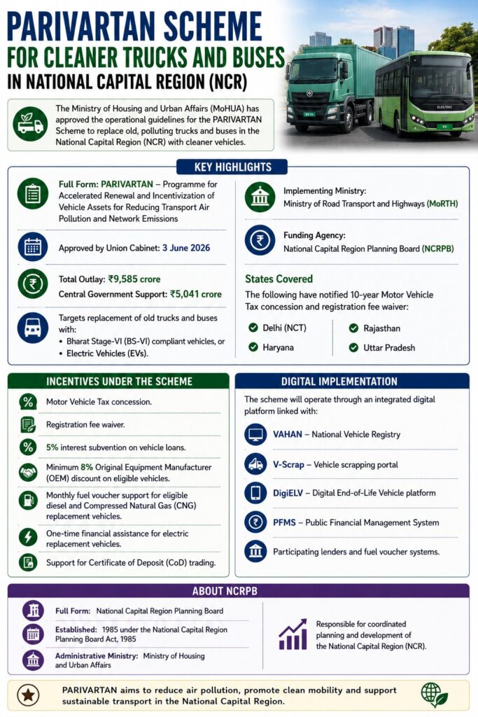
    The Ministry of Housing and Urban Affairs (MoHUA) has approved the operational guidelines for the PARIVARTAN Scheme to replace old, polluting trucks and buses in the National Capital Region (NCR) with cleaner vehicles.

    Key Highlights

    • Full Form: PARIVARTAN – Programme for Accelerated Renewal and Incentivization of Vehicle Assets for Reducing Transport Air Pollution and Network Emissions
    • Approved by Union Cabinet: 3 June 2026
    • Total Outlay:₹9,585 crore
      • Central Government Support: ₹5,041 crore
    • Targets replacement of old trucks and buses with Bharat Stage-VI (BS-VI) compliant vehicles, or Electric Vehicles (EVs).
    • Implementing Ministry: Ministry of Road Transport and Highways (MoRTH)
    • Funding Agency: National Capital Region Planning Board (NCRPB)
    • States Covered: The following have notified 10-year Motor Vehicle Tax concession and registration fee waiver in Delhi (NCT), Haryana, Rajasthan, and Uttar Pradesh

    Incentives under the Scheme

    • Motor Vehicle Tax concession.
    • Registration fee waiver.
    • 5% interest subvention on vehicle loans.
    • Minimum 8% Original Equipment Manufacturer (OEM) discount on eligible vehicles.
    • Monthly fuel voucher support for eligible diesel and Compressed Natural Gas (CNG) replacement vehicles.
    • One-time financial assistance for electric replacement vehicles.
    • Support for Certificate of Deposit (CoD) trading.

    Digital Implementation

    The scheme will operate through an integrated digital platform linked with:

    • VAHAN – National Vehicle Registry
    • V-Scrap – Vehicle scrapping portal
    • DigiELV – Digital End-of-Life Vehicle platform
    • Public Financial Management System (PFMS)
    • Participating lenders and fuel voucher systems.

    About NCRPB

    • Full Form: National Capital Region Planning Board
    • Established: 1985 under the National Capital Region Planning Board Act, 1985
    • Administrative Ministry: Ministry of Housing and Urban Affairs.
    • Responsible for coordinated planning and development of the National Capital Region (NCR).

    [2025] Consider the following types of vehicles:
    I. Full battery Electric vehicles
    II. Hydrogen fuel cell vehicles
    III. Fuel cell electric hybrid vehicles
    How many of the above are considered as alternative powertrain vehicles?

    [A] Only one

    [B] Only two

    [C] All the three

    [D] None

  • China’s Great Green Wall

    Why in News?

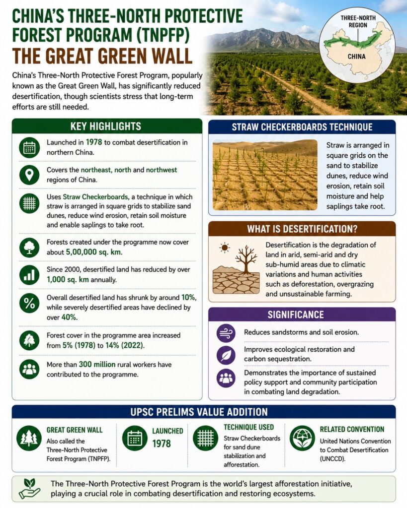
    China’s Three-North Protective Forest Program (TNPFP), popularly known as the Great Green Wall, has significantly reduced desertification, though scientists stress that long-term efforts are still needed.

    Key Highlights

    • Launched in 1978 to combat desertification in northern China.
    • Covers the northeast, north and northwest regions of China.
    • Uses *Straw Checkerboards, a technique in which straw is arranged in square grids to stabilize sand dunes, reduce wind erosion, retain soil moisture and enable saplings to take root.
    • Forests created under the programme now cover about 5,00,000 sq. km.
    • Since 2000, desertified land has reduced by over 1,000 sq. km annually.
    • Overall desertified land has shrunk by around 10%, while severely desertified areas have declined by over 40%.
    • Forest cover in the programme area increased from 5% (1978) to 14% (2022).
    • More than 300 million rural workers have contributed to the programme.

    What is Desertification?

    • Desertification is the degradation of land in arid, semi-arid and dry sub-humid areas due to climatic variations and human activities such as deforestation, overgrazing and unsustainable farming.

    Significance

    • Reduces sandstorms and soil erosion.
    • Improves ecological restoration and carbon sequestration.
    • Demonstrates the importance of sustained policy support and community participation in combating land degradation.

    UPSC Prelims Value Addition

    • Great Green Wall: Also called the Three-North Protective Forest Program (TNPFP).
    • Launched: 1978.
    • Technique Used: Straw Checkerboards for sand dune stabilization and afforestation.
    • Related Convention: United Nations Convention to Combat Desertification (UNCCD).

    [2016] What is/are the importance/importances of the ‘United Nations Convention to Combat Desertification’?

    1. It aims to promote effective action through innovative national programmes and supportive international partnerships.
    2. It has a special/particular focus on South Asia and North Africa regions, and its Secretariat facilitates the allocation of major portion of financial resources to these regions.
    3. It is committed to bottom-up approach, encouraging the participation of local people in combating the desertification.

    Select the correct answer using the code given below.

    [A] 1 only

    [B] 2 and 3 only

    [C] 1 and 3 only

    [D] 1, 2 and 3

  • Indian Grey Hornbill Returns to Gir

    Why in News?

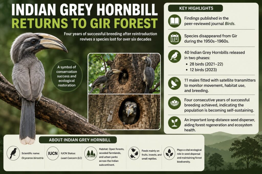
    The Indian Grey Hornbill has recorded four consecutive years of successful breeding in Gujarat’s Gir Forest after being reintroduced in 2021, marking the revival of a species that disappeared from the region over six decades ago.

    Key Highlights

    • The findings were published in the peer-reviewed journal Birds.
    • The species had disappeared from Gir during the 1950s-1960s.
    • 40 Indian Grey Hornbills were released in two phases: 28 birds (2021-22) and 12 birds (2023)
    • 11 males were fitted with satellite transmitters to monitor movement, habitat use, and breeding.
    • The project has achieved four consecutive years of successful breeding, indicating the population is becoming self-sustaining.
    • The Indian Grey Hornbill is an important long-distance seed disperser, aiding forest regeneration.

    About Indian Grey Hornbill

    • Scientific name: Ocyceros birostris
    • IUCN Status: Least Concern (LC)
    • Habitat: Open forests, wooded farmlands, and urban parks across the Indian subcontinent.
    • Feeds mainly on fruits, insects, and small reptiles.
    • Plays a vital ecological role in seed dispersal and maintaining forest biodiversity.

    [2020] With reference to India’s biodiversity, Ceylon frogmouth, Coppersmith barbet, Gray-chinned miniyet and White-throated redstart are

    a) Birds
    b) Primates
    c) Reptiles
    d) Amphibians

  • Will El Niño Weaken India’s Economy

    Why in the News?

    India’s monsoon has opened with a 40% rainfall deficit in June, and the India Meteorological Department has forecast a second consecutive below-normal month in July. The forecast has revived concern that a potential “super” El Niño could damage agricultural output, rural income, and food prices. India enters this season on the back of record 2024-25 foodgrain output, which is what a poor monsoon now puts at risk.

    How does a weak monsoon transmit into the broader economy beyond agriculture?

    1. Three transmission channels: A weak monsoon damages the economy through lower agricultural output, reduced rural income, and rising food prices.
    2. Cropping pattern shift: Farmers are shifting toward pulses and away from maize and vegetables. Pulses need less water and cost less to cultivate.
    3. Irrigation-linked decision-making: Planting decisions also depend on irrigation access, MSP levels, procurement support, and market conditions.
    4. Rural non-farm contraction: Non-traded rural services such as construction contract when agricultural income falls.
    5. Early economic signals: Two-wheeler and tractor sales weaken first. Real estate demand in smaller towns and cities follows.
    6. Export exposure: Agriculture exports grew at a CAGR of 8.2% between fiscals 2020 and 2025, contributing 12% of India’s core exports. A weak kharif season threatens this growth.

    Why does a weak monsoon strain macro-fiscal and external balances even before the shortfall materialises?

    1. Fertiliser subsidy commitment: The Union Cabinet approved a ₹41,533 crore Nutrient-Based Subsidy (NBS: a fixed per-nutrient, rather than per-product, fertiliser subsidy) for phosphatic and potassic fertilisers for the kharif season, covering 28 grades.
    2. Import and buffer-stock risk: A shortfall in kharif output will force the government to release buffer stocks and import commodities. This widens the Current Account Deficit (CAD: the gap between a country’s foreign exchange outflows and inflows on the current account) and pressures the rupee.
    3. Compounding supply shock: Pest pressure and fertiliser input constraints linked to the Iran conflict are adding to cost pressure ahead of the monsoon outcome.
    4. Growth cost estimate: A combined El Niño-plus-drought scenario may shave 20 to 65 basis points off GDP growth, according to Kotak Mutual Fund.
    5. RBI’s growth-inflation warning: The Reserve Bank of India’s June bulletin flagged that an adverse south-west monsoon could weigh on the domestic growth-inflation outlook.

    Why did the 2009 and 2015 El Niño years produce such different economic outcomes despite similar monsoon failure?

    1. El Niño as an imperfect predictor: Six of the eleven below-normal or deficient monsoon years since 2000 were classified as El Niño years by the IMD. Five of these six saw deficient rainfall.
    2. 2009-10 outcome: Two consecutive years of rainfall stress, combined with all-India irrigation cover below 45%, contracted crop GVA (Gross Value Added: a sector’s contribution to national output, net of input costs) by 2.5% and 3.2% in fiscals 2009 and 2010. Inflation entered double digits.
    3. 2014-15 output impact: El Niño intensified from weak to strong across these two years. Crop GVA contracted again in both years.
    4. 2014-15 price impact: Food inflation stayed muted in 2015. This differed sharply from the double-digit inflation of 2009-10.
    5. Explanation for the divergence: Proactive food management, restrained MSP hikes, and a global commodity price slump kept 2015 inflation low.
    6. What the comparison establishes: Policy response, not rainfall severity alone, determines whether an El Niño year turns into an inflation crisis.

    How exposed is India’s irrigation and storage system to a second successive weak monsoon?

    1. Vulnerable districts: 315 districts have been flagged as vulnerable to a poor monsoon. Of these, 111 districts across 12 States are of primary concern for poor irrigation facilities.
    2. Reservoir storage shortfall: Storage across the 166 reservoirs monitored by the Central Water Commission stood at 47.725 BCM (Billion Cubic Metres) on July 2. This is below both the year-ago level of 78.077 BCM and the normal level of 48.402 BCM for this time of year.
    3. Current buffer, limited margin: The present storage position can meet requirements. A second consecutive weak monsoon would strain it.
    4. Structural irrigation gap: All-India average irrigation cover remains below 45%, the same constraint that contributed to the 2009-10 GVA contraction.

    Should India replace crop insurance with ex-ante risk reduction as its primary drought response?

    1. Limits of crop insurance: Crop insurance compensates farmers after a monsoon failure. It does not reduce their underlying exposure to rainfall variability.
    2. Ex-ante alternative: Ex-ante risk reduction requires sustained public investment in irrigation infrastructure rather than compensation after the event.
    3. Seed access gap: Drought-resistant, high-yielding seed varieties are necessary. Farmers who need them most lack access to them.
    4. Investment shortfall: Public investment in irrigation and seed access has been inadequate. This explains why agricultural disaster preparedness remains poor.

    Conclusion

    A weak monsoon does not automatically translate into an economic crisis. The 2009 and 2015 El Niño years show that policy response, not rainfall alone, determines the scale of the damage. India’s current toolkit remains weighted toward reactive measures, crop insurance, buffer stock release, price management, rather than ex-ante investment in irrigation and drought-resistant seed. Until public investment shifts from compensating farmers after a bad monsoon to reducing their exposure to it, each El Niño year will continue to test the same vulnerabilities: rainfed districts, thin irrigation cover, and reservoirs running below normal.

    PYQ Relevance

    [UPSC 2023] Discuss the consequences of climate change on the food security in tropical countries.

    Linkage: The PYQ assesses the relationship between climate variability, agriculture and food security. El Niño-induced rainfall deficits directly threaten crop production, food security, rural livelihoods and agricultural sustainability, making this PYQ conceptually relevant.

  • The real crisis in Indian fisheries

    Why in the News?

    The Government of India released its latest ocean fisheries assessment on February 11, 2026, claiming most marine fish stocks are sustainable, based on CMFRI data showing 91.1% of evaluated stocks in good health. This optimistic reading is contested by the FAO’s more cautious country profile and by fisheries scientists, who argue the deeper crisis lies in the continuing destruction of India’s inshore benthic ecosystem, not in aggregate stock numbers.

    Why does the government’s claim of largely sustainable marine fisheries not hold up to scrutiny?

    1. Landing-data methodology: CMFRI estimates fish stock availability from what fishers catch. It does not directly assess fish populations at sea.
    2. Catch data as a weak proxy: Catch volume cannot reliably indicate how much aquatic life remains in the sea. Finding shells on a beach does not predict the shell count underwater.
    3. FAO’s contrasting assessment: The FAO’s India country profile states marine fisheries production has plateaued. Most major stocks are already fully exploited.
    4. Unregulated capacity growth: The FAO links this plateau to unregulated fishing access. This access created overcapacity among medium and small trawlers competing for shrinking resources.
    5. Undisclosed procedures: CMFRI’s methodology for classifying stocks as sustainable is not made public. This limits independent verification.
    6. Possible strategic bias: Competitive pressure to match China’s fisheries output may be shaping how India presents its stock data.

    Is overfishing really the central problem facing India’s fisheries?

    1. Reframing the crisis: The more pressing concern is the decline of the inshore benthic environment. Benthic environment, the ecological zone at the seabed where bottom-dwelling organisms live.
    2. Expert consensus on destruction: Fisheries scientists and policymakers have described the inshore fishing environment as destroyed over the past year.
    3. Where productivity concentrates: India’s continental shelf is narrow across most of the coastline. This makes inshore waters the most productive fishing zone.
    4. Overlap of protective zones: Territorial waters within 12 nautical miles largely overlap with this continental shelf. These waters support the breeding of commercially valuable species such as shrimp.
    5. Ground-level testimony: Fishers along the Tamil Nadu coast report consistent declines in catch. Many previously common species have disappeared.

    What is driving the destruction of India’s inshore fishing grounds?

    1. Disrupted nutrient flow: Dams on major rivers block land-based nutrients from reaching the sea. This weakens the coastal food chain.
    2. Mangrove loss: Ongoing destruction of mangroves removes critical breeding habitat for fish.
    3. Multi-source pollution: Industrial, agricultural, and urban pollution enters the sea. This degrades inshore water quality.
    4. Mechanised trawling’s foreign origins: Semi-industrial trawling was introduced to India from abroad around 1960. It has since expanded on a large scale.
    5. Uncontrolled fleet growth: India now operates 64,414 mechanised fishing vessels. There are no restrictions on new entries.
    6. Technological escalation: Existing vessels are being retrofitted with more powerful Chinese engines. This increases their catch capacity further.
    7. Continuous seabed disturbance: Trawlers plough the inshore seabed continuously. This causes a decline in all animal and plant life in heavily trawled zones.

    What limited external reference points does the article offer on managing trawling pressure?

    1. Assessment method abroad: Other fishing nations reportedly rely on direct at-sea stock assessments rather than catch data alone. The article does not name specific countries or institutions.
    2. China as competitive pressure, not model: China is referenced only as a competitor whose fisheries growth may be biasing India’s reporting. It is not presented as an institutional example.
    3. Palk Bay as cross-border conflict: Indian mechanised trawlers cross into Sri Lankan waters in the Palk Bay. This shows domestic overcapacity exporting itself as a bilateral fisheries conflict.

    Why do existing rules meant to protect inshore waters fail in practice?

    1. Toothless zone restriction: Mechanised boats are barred from fishing within 5 nautical miles of shore. This restriction lacks enforcement.
    2. Limited seasonal relief: A two-month annual ban on mechanised boat fishing allows some stock rejuvenation. It does not address year-round degradation.
    3. Patrol capacity gap: Coastal states lack sufficient staff and craft to monitor and enforce inshore fishing boundaries.
    4. Exclusion of fishers from governance: Governments have kept fishers out of management roles. This removes a source of on-ground enforcement and information.
    5. Competing fleets pushed outward: Both small-scale and mechanised fishers are being forced toward offshore and deep-sea zones as inshore waters degrade.

    Does redirecting fishers toward deep-sea fishing resolve the crisis in India’s fisheries?

    1. Government’s proposed shift: The government is encouraging fishers to move toward deep-sea fishing. It views this as untapped potential.
    2. FAO’s caution on deep-sea potential: The FAO estimates deep-sea fishing can deliver only a marginal increase in output. It is not a transformative gain.
    3. New costs imposed on fishers: Shifting to distant waters requires fishers to bear higher fuel and technology expenses.
    4. Root problem left unaddressed: The shift avoids confronting marine pollution and unregulated mechanised trawling. These remain the actual drivers of inshore decline.
    5. Political economy obstacle: Mechanised boat fishers wield disproportionate numeric and political influence. This obstructs reform of inshore management.

    Conclusion

    The government’s sustainability claim rests on landing data, not direct stock assessments, and says nothing about the condition of the inshore seabed itself. The actual crisis lies in the continuing degradation of inshore fishing grounds, driven by an unregulated and politically entrenched mechanised trawling fleet that existing laws cannot enforce against. Redirecting fishers toward deep-sea fishing does not resolve this; it relocates the burden while leaving inshore governance unreformed. Genuine sustainability requires stronger coastal governance, enforceable trawling limits, and empirical assessment of the benthic environment itself.