đŸ’„Join UPSC 2027,2028 Mentorship (July Batch) + XFactor Notes & Microthemes PDF

Subject: Environment

  • Fighting forest fires with a plan and community cooperation

    Why in the news? 

    The forest staff across the Kerala State are on alert with the onslaught of summer, with temperatures reaching as high as 40-41 degrees Centigrade, unusual for this time.

    Forest Fires in Kerala 

    • Kerala records relatively fewer forest fires compared to several other states in India, including Chhattisgarh, Odisha, Madhya Pradesh, Assam, and Maharashtra.
    • Kerala’s forest cover, occupying 29.65% of the land, is dominated by deciduous and semi-deciduous woods that are drying up, especially on the forest periphery because of it Forest staff in Kerala are on alert
    •  Kerala reported 163 wildfire incidents since January, resulting in the burning of 230 hectares of forest, which is less compared to previous years.
    • Global Forest Watch data indicates 97 VIIRS(Visible Infrared Imaging Radiometer Suit) fire alerts in Kerala between March 15 and 22, with only 5.2% of them classified as high-confidence alerts.Fires were responsible for 0.33% forest cover loss in Kerala between 2001 and 2022 according to Global Forest Watch.

    What is the frequency of forest fires in India?

    •  Escalation Of forest Fire : Forest fire season in India typically spans from November to June, during which hundreds of thousands of small and large fires occur annually. The frequency of fires tends to escalate from February onwards as summer approaches.
    • forest Fires as per (ISFR) : In its 2021 report, the biennial India State of Forest Report (ISFR) released by the Forest Survey of India (FSI) indicates that 35.47% of the forest cover is classified as fire-prone areas.

    Region more prone to forest Fire

    • Fires of severe magnitude occur frequently in dry deciduous forests, whereas evergreen, semi-evergreen, and montane temperate forests are relatively less susceptible to fires.
    • During the November to June period, the forests in Northeast India, Odisha, Maharashtra, Jharkhand, Chhattisgarh, and Uttarakhand face the highest risk of fires.For example in 2021, a string of forest fires occurred in Uttarakhand, Himachal Pradesh, the Nagaland-Manipur border, Odisha, Madhya Pradesh, and Gujarat, including within wildlife sanctuaries.
    • In 2024 forest Fires: According to data from the Forest Survey of India (FSI), Mizoram reported the highest number of forest fires (3,738), followed by Manipur (1,702), Assam (1,652), Meghalaya (1,252), and Maharashtra (1,215).

    Reason behind the forest fires in India 

    The majority of forest fires in India are ignited by human activities, including:

    • Agricultural Burning: Farmers often use fire to clear land for cultivation or to manage crop residues, leading to accidental fires spreading into nearby forests.For example Jhum (slash and burn cultivation)
    • Intentional Arson: Deliberate setting of fires for various reasons, such as land grabbing, hunting, or retaliatory actions.
    • Carelessness: Unattended campfires, discarded cigarettes, or burning of waste materials can spark fires.
    • Climate Conditions: Dry and hot weather conditions during the summer months create favorable conditions for the rapid spread of fires. .For example forest fires has worsen due to climate change as per UNEP

    Plan for Fighting forest Fires 

    • Early Detection: Implement systems for early detection of forest fires, such as fire watchtowers, aerial surveillance, and remote sensing technologies like drones and satellites.
    • Rapid Response: Develop well-trained and equipped firefighting teams capable of swift response to contain fires in their early stages before they escalate.
    • Controlled Burns: Conduct controlled burns during cooler and wetter months to remove excess vegetation and reduce the risk of large-scale wildfires during dry seasons.
    • Firebreaks: Create and maintain firebreaks by clearing vegetation along strategic points to halt the spread of fires.
    • Community Involvement: Educate local communities about fire prevention and train them in firefighting techniques. Encourage community participation in fire management efforts.
    • Equipment and Infrastructure: Ensure availability and proper maintenance of firefighting equipment such as hoses, pumps, bulldozers, and firefighting aircraft.

    Conclusion 

    Forest fires in India, exacerbated by climate conditions, pose significant threats. Kerala’s proactive measures and community involvement highlight effective strategies for prevention and control, crucial in mitigating the increasing frequency of fires nationwide.


     https://www.downtoearth.org.in/news/natural-disasters/wildfires-will-be-more-frequent-larger-and-intense-due-to-climate-change-unep-81615

  • In news: Ramapo Fault

    Why in the news?

    • An earthquake of magnitude 4.8 hit the New York City in a rare event.
    • The Ramapo Fault in Appalachian Mountains near New Jersey is a being considered as a reason behind this earthquake.

    Appalachian Mountains

    • The Appalachian Mountains extend from the Canadian province of Newfoundland and Labrador in the north to central Alabama in the southern US.
    • The total length of the Appalachian Mountain range is approximately 2,200 miles (3,500 kilometers), making it one of the longest mountain chains in the world.
    • Geologically, it is one of the oldest mountain ranges on Earth, formed over 480 million years ago during the Ordovician Period. They are considered a Paleozoic mountain range.
    • They were formed through a series of tectonic collisions and uplift events, including the assembly of the supercontinent Pangaea.
    • The highest peak in the range is Mount Mitchell in North Carolina, standing at an elevation of 6,684 feet (2,037 meters) above sea level.
    • The Appalachian Mountains hold cultural significance for various indigenous tribes, including the Cherokee, as well as early European settlers who established communities in the region.

    About Ramapo Fault

    • Fault lines are fractures in the Earth’s crust that facilitate movement of tectonic plates, triggering earthquakes.
    • The Ramapo Fault is resulted from tectonic activity associated with the breakup of the supercontinent Pangaea during the Mesozoic Era.
    • It is primarily a right-lateral strike-slip fault, formed by horizontal movement along the fault line due to the ongoing motion between the North American and Eurasian plates.
    • While the Ramapo Fault is not as seismically active as faults in other regions, it has experienced earthquakes in the past and remains a potential source of seismic hazards.

    Geographical Distribution:

    • The fault extends across three states in the northeastern United States: Pennsylvania, New Jersey, and New York.
    • The fault crosses various topographic features, including rift valleys, hills, and ridges, reflecting the diverse geological history of the region.
    • It intersects with the Appalachian Mountains, influencing the overall topography of the surrounding areas.

    PYQ:

    [2012] When you travel in Himalayas, you will see the following:

    1.    Deep gorges

    2.    U-turn river courses

    3.    Parallel mountain ranges

    4.    Steep gradients causing land-sliding

    Which of the above can be said to be the evidences for Himalayas being young fold mountains?

    (a) 1 and 2 only

    (b) 1, 2 and 4 only

    (c) 3 and 4 only

    (d) 1, 2, 3 and 4


  • Why Uttarakhand govt wants to evaluate the risk of Glacial Lake Outburst Floods

    Why in the news? 

    Recently, the Uttarakhand government has constituted two teams of experts to evaluate the risk posed by five potentially hazardous glacial lakes in the region.

    Context:

    • The Hazardous Glacial Lakes are prone to Glacial Lake Outburst Floods (GLOFs), the kind of events that have resulted in several disasters in the Himalayan states in recent years.
    • The National Disaster Management Authority (NDMA), which operates under the Union Ministry of Home Affairs, has identified 188 glacial lakes in the Himalayan states that can potentially be breached because of heavy rainfall. Thirteen of them are in Uttarakhand.

    About Glacial Lake Outburst Floods (GLOFs):

    GLOFs are disaster events caused by the abrupt discharge of water from glacial lakes  large bodies of water that sit in front of, on top of, or beneath a melting glacier. As a glacier withdraws, it leaves behind a depression that gets filled with meltwater, thereby forming a lake. Example: 4 october 2023 GLOFs in Sikkim.

    Factors behind the GLOFs:

    • Avalanches or Landslides: Incidents such as avalanches or landslides can also impact the stability of the boundary around a glacial lake, leading to its failure, and the rapid discharge of water.
    • Due to climate change: Rising surface temperatures across the globe, including India, have increased the risk of GLOFs. Studies have shown that around 15 million people face the risk of sudden and deadly flooding from glacial lakes, which are expanding and rising in numbers due to global warming.
    • Rapid infrastructure development in vulnerable areas has also contributed to the spike in such incidents.
    • Sizable ice chunks in the lake: GLOFs can be triggered by various reasons, including glacial calving, where sizable ice chunks detach from the glacier into the lake, inducing sudden water displacement.

    Why are GLOFs under the spotlight?

    • Increased Frequency of GLOFs: Since 1980, GLOFs have become more frequent in the Himalayan region, particularly in southeastern Tibet and the China-Nepal border area. This indicates a concerning trend of glacial melting and lake formation as per Institute of Tibetan Plateau Research in China
    • Extent of Potential Risk: The analysis by  Institute of Tibetan Plateau Research in China suggests that approximately 6,353 sq km of land could be at risk from potential GLOFs.
    • Regional Impacts: Another analysis conducted by Caroline Taylor, Rachel Carr, Stuart Dunning (Newcastle University, UK), Tom Robinson (University of Canterbury, New Zealand), and Matthew Westoby (Northumbria University, UK) indicates that GLOFs are not just a localized issue but have broader regional impacts.
      • Around 3 million people in India and 2 million in Pakistan are identified as facing the risk of GLOFs, highlighting the potential humanitarian consequences of these events.

    What is the situation in Uttarakhand?

    • Past GLOF events: Uttarakhand has experienced two major GLOF events in recent years. The first occurred in June 2013, affecting large parts of the state, particularly the Kedarnath valley, resulting in significant loss of life.
      • The second event happened in February 2021 in Chamoli district, leading to flash floods due to the bursting of a glacier lake.
    • Categorization of Glacial Lakes: Uttarakhand has 13 glacial lakes categorized into three risk levels: ‘A’, ‘B’, and ‘C’.
      • Five highly sensitive lakes fall into the ‘A’ category, including Vasudhara Tal in the Dhauliganga basin (Chamoli district), Maban Lake, Pyungru Lake, and two unclassified lakes in Pithoragarh district.
    • Size and Elevation of High-Risk Lakes: The lakes in the ‘A’ category have areas ranging from 0.02 to 0.50 sq km and are situated at elevations between 4,351 to 4,868 meters above sea level. These characteristics make them particularly vulnerable to glacial lake outburst events.
    • Impact of Rising Temperatures: A 2021 study by the Potsdam Institute for Climate Research (PIK) and The Energy and Resources Institute (TERI) suggests that rising surface temperatures could worsen the situation in Uttarakhand.
      • The state’s annual average maximum temperature may increase by 1.6-1.9 degrees Celsius between 2021-2050, potentially exacerbating the risk of GLOFs.

    Conclusion: Uttarakhand government forms expert teams to assess risk from 5 hazardous glacial lakes prone to GLOFs. With rising temperatures and past disasters, urgent action is needed to mitigate potential catastrophic flooding.

  • Indian Laurel Tree (Terminalia tomentosa)

    Why in the news?

    • Forest Department officials’ examination of an Indian laurel tree (Terminalia tomentosa) in Papikonda National Park has showcased its remarkable water storage capability.
    • This discovery sheds light on the indigenous knowledge shared by the Konda Reddi tribe regarding the tree’s unique attributes.

    Konda Reddi Tribe


    • The Konda Reddis are a Particularly Vulnerable Tribal Group (PVTG) residing in the Godavari riverbanks and the hilly forest areas of Godavari and Khammam districts in Andhra Pradesh.
    • The family structure is patriarchal and patrilocal, with monogamy as the norm with some exceptions.
    • The Konda Reddis are primarily Hindus with folk customs, which involves local traditions and worship of community-level deities.
    • They have their own social control institution called ‘Kula Panchayat’.
    • Each village has a traditional headman known as ‘Pedda Kapu’, whose role is hereditary.
    • Their primary occupation is shifting cultivation, relying on forest flora and fauna for sustenance.
    • Jowar cultivation is prevalent, serving as their staple food.
    • They collect and sell non-timber forest products like tamarind, adda leaves, myrobolan, and broomsticks to supplement their income.


    About Papikonda NP


    • Papikonda NP is located in the East Godavari and West Godavari districts of Andhra Pradesh.
    • It was established as a national park in the year 2008.
    • It is characterized by hilly landscapes, dense moist deciduous forest.
    • The presence of the Godavari River cuts through the Papikonda hill range of Eastern Ghats.


    About Indian Laurel Tree

    Description
    Scientific Name Terminalia tomentosa
    Common Names Indian Laurel Tree, Crocodile Bark Tree, Anjan Tree
    Habitat Found in Deciduous forests
    Bark Scissored and cracked bark, resembling crocodile skin (From November to February)
    Water Storage Ability Only 5-10% of trees observed to store water in the stem
    Water Storage Mechanism Development of lateral ridge, known as a wing, on trunk, indicating water presence
    Water Collection 4-6 litres of potable water can be collected from a fully grown tree by making a small hole in the wing
    Traditional Use Used by tribal communities, such as the Konda Reddi Tribe, as a water source during dry seasons
    Adaptability Thrives in various conditions, including harsh weather and drought


    PYQ:

    2015:

    In India, in which one of the following types of forests is teak a dominant tree species?

    (a) Tropical moist deciduous forest

    (b) Tropical rain forest

    (c) Tropical thorn scrub forest

    (d) Temperate forest with grasslands


    Practice MCQ:

    The Indian Laurel Tree (Terminalia tomentosa) recently seen in news is famous for its:

    (a) Ability to store water in its trunk

    (b) Therapeutic use in the treatment of Cancer

    (c) Aromatic Timber

    (d) Pulp for paper industry

  • Criollo: Cattle Breed that can withstand Climate Change

    Why in the news?

    Irish researchers discovered that Criollo cattle are well-adapted to Climate Change due to their ability to thrive in hot and humid conditions, which they have developed over many years.

    About Criollo Cattle Breed

    Details
    Origin Latin America, particularly in regions such as Mexico, Central America, and parts of South America
    Historical Context
    • Criollo cattle trace their roots back to the arrival of Spanish cattle in the Americas during the 15th and 16th centuries.
    • Initially brought from La Gomera in the Spanish Canary Islands, adapted to diverse environments.
    Physical Appearance
    • Small to medium-sized cattle with a compact body structure
    • Adapted to various climates, including tropical and subtropical regions
    • Short, sleek coat, often in various colors such as black, brown, or red
    Adaptability Known for their resilience and ability to thrive in harsh environments

    Well-suited to extensive grazing systems and low-input management practices

    Disease Resistance Developed natural resistance to various diseases prevalent in their native regions, such as tick-borne illnesses and parasites
    Economic Importance
    • Valued for their ability to utilize low-quality forages and adaptability to diverse environments
    • Serve as a sustainable source of meat and dairy products for local communities


    PYQ:

    2016:

    What is/are unique about ‘Kharai camel’, a breed found in India?

    1. It is capable of swimming up to three kilometres in seawater.

    2. It survives by grazing on mangroves.

    3. It lives in the wild and cannot be domesticated.

    Select the correct answer using the codes given below:

    (a) 1 and 2 only

    (b) 3 only

    (c) 1 and 3 only

    (d) 1, 2 and 3


    Practice MCQ:

    The Criollo cattle breed has recently found mention in the news for its:

    (a) Breeding Capacity

    (b) Nutrients-rich Milk

    (c) Adaptability to Climate Change

    (d) Life Expectancy

  • Taiwan’s Earthquake and the Pacific Ring of Fire

    Why in the news?

    • Taiwan was struck by its most powerful earthquake in at least 25 years.
    • Its susceptibility to earthquakes is attributed to its location along the Pacific “Ring of Fire” where a majority of the world’s seismic activity occurs.
    • Taiwan is primarily influenced by the collision of the Philippine Sea Plate and the Eurasian Plate.

    What is the Pacific ‘Ring of Fire’?

    • The Pacific ‘Ring of Fire’ or Pacific Rim, or the Circum-Pacific Belt, is an area along the Pacific Ocean that is characterized by active volcanoes and frequent earthquakes.
    • Volcanic arcs and oceanic trenches partly encircling the Pacific Basin form the so-called Ring of Fire.
    • It is home to about 75 per cent of the world’s volcanoes – more than 450 volcanoes.
    • Also, about 90 per cent of the world’s earthquakes occur here.

    Its spread

    • Its length is over 40,000 kilometres and traces from New Zealand clockwise in an almost circular arc covering Tonga, Kermadec Islands, Indonesia.
    • It is moving up to the Philippines, Japan, and stretching eastward to the Aleutian Islands, then southward along the western coast of North America and South America.

    Seismic activity of the region

    • The area is along several tectonic plates including the Pacific plate, Philippine Plate, Juan de Fuca plate, Cocos plate, Nazca plate, and North American plate.
    • The movement of these plates or tectonic activity makes the area witness abundant earthquakes and tsunamis every year.
    • Along much of the Ring, tectonic plates move towards each other creating subduction zones.
    • One plate gets pushed down or is subducted by the other plate.
    • This is a very slow process – a movement of just one or two inches per year.
    • As this subduction happens, rocks melt, become magma and move to Earth’s surface and cause volcanic activity.

    PYQ:

    2020: Discuss the geophysical characteristics of Circum-Pacific Zone.

  • Caracals on the brink of extinction in India

    Why in the news?

    • With only an estimated 50 individuals remaining, predominantly in western India, the caracal (Caracal caracal schmitzi) is on the verge of extinction in the country.
    • Ranthambhore Tiger Reserve in Rajasthan and Kutch in Gujarat are the last strongholds for caracals in India, hosting around 28 and 20 individuals, respectively.

    About Caracals

    • Caracals are small wild cats known for their long ears with tufts and a reddish-tan or sandy-brown fur. It is called Siya Gosh in India.
    • It is nocturnal animal typically preys upon small mammals, birds, and rodents.
    • They live naturally in India, especially in Northwestern India. They are also found in Africa, the Middle East, and Central Asia.
    • They are found in Aravalli hill range, semi-deserts, savannahs, scrublands, and dry forests.
    • Caracals used to live all over Central India and the Indo-Gangetic plains, but they haven’t been spotted in those areas for 40 years.

    Conservation Status

    • Caracals are listed as ‘Least Concern‘ on the IUCN Red List globally.
    • It is listed as Near Threatened in India,
    • It falls in the Schedule-I of the Indian Wildlife (Protection) Act, 1972.

    Protection Efforts

    • In 2021, the National Board for Wildlife (NBWL) and the Ministry of Environment, Forest and Climate Change (MOEFCC) announced a plan to recover and increase the population of 22 species in India, including caracals.
    • Areas like Kutch, Aravalli mountains, Malwa plateau, and Bundelkhand region have been identified as potential habitats, with the Ranthambore-Kuno Landscape being a key conservation site.

    PYQ:

    2017:

    In India, if a species of tortoise is declared protected under Schedule I of the Wildlife (Protection) Act, 1972, what does it imply?

    (a) It enjoys the same level of protection as the tiger.

    (b) It no longer exists in the wild, a few individuals are under captive protection; and now it is impossible to prevent its extinction.

    (c) It is endemic to a particular region of India.

    (d) Both B and C stated above are correct in this context.

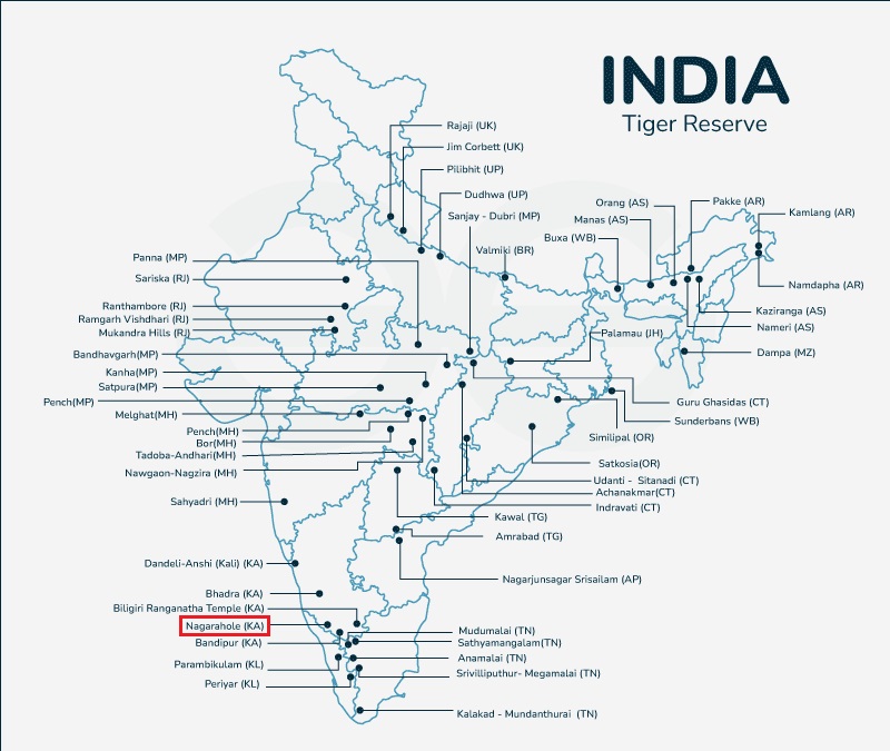
  • Nagarjunasagar-Srisailam Tiger Reserve (NSTR)

    Why in the news?

    The Forest Department and a temple authority at Ahobilam have imposed certain restrictions on visitors arriving at a shrine in Nagarjunasagar-Srisailam Tiger Reserve (NSTR).

    About Nagarjunasagar-Srisailam Tiger Reserve

    Details
    Origin of Name Named after Nagarjuna Sagar Dam and Srisailam Dam.
    Location Situated in the Nallamala hill range, part of the Eastern Ghats in Andhra Pradesh.
    Area Largest tiger reserve area in India, covering a total area of 3727 sq km.
    Wildlife Sanctuaries Constituted by the Rajiv Gandhi Wildlife Sanctuary and the Gundla Brahmeswaram Wildlife Sanctuary.
    Vegetation Features tropical, dry, moist, deciduous vegetation with diverse flora and fauna.
    Topography Consists of plateaus, ridges, gorges, and deep valleys.
    River Krishna Traverses through the reserve for approximately 270 kilometers.
    Additional Information
    • Attained tiger reserve status in 1983.
    • Home to Bengal tigers, Indian leopards, and more.
    • Habitat contains several endemic species of plants.
    • Tropical dry deciduous forests with bamboo and grass undergrowth.


    PYQ:

    2020:

    Among the following Tiger Reserves, which one has the largest area under “Critical Tiger Habitat”?

    (a) Corbett

    (b) Ranthambore

    (c) Nagarjunsagar-Srisailam

    (d) Sunderbans


    2015:

    Consider the following pairs :

    Place of Pilgrimage: Location

    1.    Srisailam : Nallamala Hills

    2.    Omkareshwar : Satmala Hills

    3.    Pushkar : Mahadeo Hills

    Which of the pairs given above is/are correctly matched?

    (a) 1 only

    (b) 2 and 3 only

    (c) 1 and 3 only

    (d) 1, 2 and 3


    Practice MCQ:

    It is the largest tiger reserve in India, covering a total area of 3727 sq km. It is constituted by the Rajiv Gandhi Wildlife Sanctuary and the Gundla Brahmeswaram Wildlife Sanctuary and features tropical, dry, moist, deciduous vegetation with diverse flora and fauna.

    Which protected area is implied by the above description?

    (a) Nagarjunasagar-Srisailam Tiger Reserve

    (b) Sathyamangalam Tiger Reserve

    (c) Kalakkad Mundanthurai Tiger Reserve

    (d) Biligiriranga Swamy Temple Tiger Reserve

  • Negative Leap Second: Climate Change’s Impact on Timekeeping

    Why in the news?

    • A recent publication in the science journal Nature highlights how climate change-induced melting of glaciers and ice sheets is altering the Earth’s rotation, potentially disrupting our timekeeping systems.
    • Leap seconds were added almost every year between 1972 and 1999 to adjust for Earth’s slowing rotation. But there have only been four added in the last 23 years, and the last time a leap second was added was in 2016.

    What is a Leap Second?

    • A leap second is a one-second adjustment that is occasionally applied to Coordinated Universal Time (UTC) in order to synchronize atomic time with astronomical time, particularly with the Earth’s rotation.
    • The purpose of adding or subtracting a leap second is to keep International Atomic Time (IAT) (which is extremely precise) in close alignment with astronomical time, which is based on the Earth’s rotation and is subject to slight variations.

    There are two types of leap seconds:

    1. Positive Leap Second:
      • A positive leap second is added to UTC when the Earth’s rotation slows down slightly, causing the length of a day to exceed 86,400 seconds.
      • This type of leap second is necessary to bring UTC back into alignment with the Earth’s rotational time.
      • Positive leap seconds are rare and occur less frequently than negative leap seconds.
    2. Negative Leap Second:
      • A negative leap second, also known as a deletion or removal of a second, occurs when the Earth’s rotation speeds up slightly, causing the length of a day to be less than 86,400 seconds.
      • Negative leap seconds are extremely rare and have only been proposed but never implemented. They are considered hypothetical and have not yet been needed to adjust UTC.
      • The concept of negative leap seconds is controversial and requires international agreement and coordination among timekeeping organizations.

    International Atomic Time (TAI)


    • TAI is a high-precision time scale based on the weighted average of atomic clocks (usually involving caesium or rubidium atoms) from various laboratories around the world.
    • It is one of the primary time scales used for scientific and technical purposes, providing a continuous and uniform time reference that is independent of the Earth’s rotation.
    • TAI is maintained since 1958 by the International Bureau of Weights and Measures (BIPM) in Paris, France.
    • Unlike UTC, which is adjusted periodically to account for the Earth’s irregular rotation, TAI is a continuous time scale that does not include any corrections for Earth’s rotation.


    How Climate Change causes Negative Leap Second?

    •  Glacial Melting: Accelerating melt rates in Greenland and Antarctica are redistributing weight across the planet, causing a slight deceleration in the Earth’s rotation.
    • Historical Context: Timekeepers have periodically added leap seconds to clocks worldwide to account for the Earth spinning faster than usual, with 27 instances recorded since the 1970s.
    • Planned Adjustment: The proposed “negative leap second” adjustment, scheduled for 2026, may be postponed until 2029 or later due to the recent deceleration in the Earth’s rotation.Top of Form

    Practice MCQ:

    What is a Leap Second?

    (a) It is a periodic adjustment added to International Atomic Time (TAI) to compensate for irregularities in Earth’s rotation.

    (b) It is an extra second added to Coordinated Universal Time (UTC) to synchronize atomic time with astronomical time.

    (c) It is the time lag measured by the atomic clocks in Outer Space-Time conditions.

    (d) It is a term used to describe the synchronization of atomic clocks with the oscillations of subatomic particles.

  • Kallakkadal: Coastal Flooding Phenomena in Kerala

    Why in the news?

    • Coastal areas of Kerala, including Alappuzha, Kollam, and Thiruvananthapuram districts, are grappling with flooding caused by high sea waves, known as swell waves or Kallakkadal in Malayalam.
    • The recent swell surge occurred following a low-pressure system originating in the South Atlantic Ocean, leading to the formation of waves reaching heights of up to 11 meters.

    What is Kallakkadal?

    1. Origin and Meaning:
    • Kallakkadal refers to coastal flooding during the (April-May) pre-monsoon season.
    • It is caused by ocean swell waves on the southwest coast of India.
    • The term “Kallakkadal” originates from Malayalam, combining “Kallan” (thief) and “Kadal” (sea), denoting the sea’s unexpected intrusion akin to a thief.
    • In 2012, the term was formally approved by the UNESCO (United Nations Educational, Scientific and Cultural Organization).
    1. Causes:
    • These waves stem from distant storms, such as hurricanes, generating significant energy transfer from the atmosphere to the water.
    • Kallakkadal typically results from strong winds in the southern Indian Ocean, generating ocean swells that travel northward towards the Kerala coast.

    Features of Kallakkadal

    • This phenomenon occurs mostly during pre-monsoon season and sometimes during post monsoon.
    • It continues for a few days.
    • It inundates the low lying coasts.
    • Initially sea recedes before the surge.
    • During high tide the run-up, water level can reach as much as 3–4 m above Maximum Water Level (MWL).

    How is it distinct from Tsunami?

    • Nature of Phenomenon: Kallakkadal, though often confused with tsunamis, arises from distant storm-generated waves, contrasting with tsunamis triggered by underwater disturbances, typically seismic activities.
    • Clarification: Understanding this distinction is crucial for implementing effective early warning systems and mitigating the impact of coastal hazards.

    PYQ:

    2017: At one of the places in India, if you stand on the seashore and watch the sea, you will find that the sea water recedes from the shore line a few kilometres and comes back to the shore, twice a day, and you can actually walk on the sea floor when the water recedes. This unique phenomenon is seen at-

    (a) Bhavnagar

    (b) Bheemunipatnam

    (c) Chandipur

    (d) Nagapattinam


    Practice MCQ:

    The Coastal areas of Kerala recently witnessed the Oceanic Swell Waves locally known as Kallakkadal. In this regard consider the following statements:

    1.    Kallakkadal typically occurs during the spring season (March-April).

    2.    These waves stem from distant storms in the southern Indian Ocean.

    Which of the given statements is/are NOT correct?

    (a) Only 1

    (b) Only 2

    (c) Both 1 and 2

    (d) Neither 1 nor 2