💥Join UPSC 2027,2028 Mentorship (July Batch) + XFactor Notes & Microthemes PDF

Subject: Geographical Features

  • What is the Hangenberg Crisis?

    The explosion of a nearby star — occurred at between Devonian and Carboniferous periods — could have caused a mass extinction event that took place 359 million years ago.

    Try this question from CSP 2018:

    Q.The term “sixth mass extinction/sixth extinction” is often mentioned in the news in the context of the discussion of

    (a) Widespread monoculture Practices agriculture and large-scale commercial farming with indiscriminate use of chemicals in many parts of the world that may result in the loss of good native ecosystems.

    (b) Fears of a possible collision of a meteorite with the Earth in the near future in the manner it happened 65million years ago that caused the mass extinction of many species including those of dinosaurs.

    (c) Large scale cultivation of genetically modified crops in many parts of the world and promoting their cultivationin other Parts of the world which may cause the disappearance of good native crop plants and the loss offood biodiversity.

    (d) Mankind’s over-exploitation/misuse of natural resources, fragmentation/loss, natural habitats, destructionof ecosystems, pollution and global climate change.

    Hangenberg crisis

    • The Earth suffered an intense loss of species diversity that lasted for at least 300,000 years.
    • The event is thought to have been caused by long-lasting ozone depletion, which would have allowed much more of the Sun’s ultraviolet (UV) radiation to reach and harm life on Earth.
    • It was called the Hangenberg crisis.

    What did researchers find?

    • Extensive volcanism and global warming can also rupture the ozone layer but shreds of evidence for these are indefinite as far as the time period is concerned.
    • So, they up that one or more supernovae explosions, at a distance of 65 light-years away from the Earth, may have caused a prolonged loss of ozone.
    • Betelgeuse, a supernova, around 600 light-years away and present outside the kill distance of 25 light-years poses a danger today.
    • Events like gamma-ray bursts, solar eruptions and meteorite collisions end up very soon. As such, they cannot pave the way for gradual ozone depletion that took place at the close of the Devonian aeon.
    • A supernova event can be powerful enough to bathe its galaxy in light for days and months alike. It can be spotted across the universe as well.

    Why Supernovae are considered dangerous?

    • Supernovae (SNe) are quick sources of ionizing photons that include fatal X-rays, UV and gamma rays.
    • Over a longer period of time, the bang clashes with the nearby gas, resulting in a shockwave that causes particle acceleration.
    • As such, cosmic rays are generated by SNe. These charged particles with high energies get magnetically confined on the inside of SN remains.
    • The fossil evidence shows a 300,000-year shrink in biodiversity leading the way to Devonian-Carboniferous Boundary (DCB) mass extinction.
    • This puts forward the possibility of multiple catastrophes or multiple supernovae explosions.
  • Tornado’s dynamics and its India connection

    Babu ChunderSikur Chatterjee’s paper was the earliest record of a tornado’s dynamics in the history of meteorology, according to a study.

    Try this PYQ:

    Q. In the South Atlantic and South-Eastern Pacific regions in tropical latitudes, cyclone does not originate. What is the reason? (CSP 2015)

    (a) Sea surface temperatures are low

    (b) Inter-Tropical Convergence Zone seldom occurs

    (c) Coriolis force is too weak

    (d) Absence of land in those regions

    What is a Tornado?

    • A tornado is a rapidly rotating column of air that is in contact with both the surface of the Earth and a cumulonimbus cloud or, in rare cases, the base of a cumulus cloud.
    • The windstorm is often referred to as a twister, whirlwind or cyclone winds blow counterclockwise in the Northern Hemisphere and clockwise in the Southern.
    • Tornadoes come in many shapes and sizes, and they are often visible in the form of a condensation funnel originating from the base of a cumulonimbus cloud, with a cloud of rotating debris and dust beneath it.
    • It is generally accompanied by extreme weather such as heavy downpours, hail storms, and lightning.

    Who was Babu ChunderSikur Chatterjee?

    • Chatterjee was an Indian scientist employed with the Surveyor General of India during the British colonial era.
    • He was likely the first person to scientifically document a tornado’s path in 1865, a study from the Indian Institute of Tropical Meteorology (IITM), Pune, has claimed.
    • Chatterjee had published his findings in a journal named Proceedings of the Asiatic Society of Bengal, in a paper titled ‘Note on a whirlwind at Pundooah’, near Hooghly.
    • The paper described a tornado’s dynamics in meticulous detail and was accompanied by a sketch that mathematically depicted its scale, track and rotation.

    His work


    • Chatterjee quantitatively mapped the entire trail of á tornado’s destruction.
    • He benefited from the rare opportunity to observe a tornado passing through a railway track where there were conveniently placed markers at predefined locations.
    • This enabled him to observe and make clear measurements of the tornado’s direction, dynamics and path.

    Back2Basics

  • [pib] Himalayan Geothermal Springs release huge amount of carbon dioxide in the atmosphere

    The Himalayas, which hosts about 600 geothermal springs needs to be considered while estimating emissions to the carbon cycle and thereby to global warming says, Indian researchers.

    Note the following hot springs in India:

    1) Panamik in Nubra valley

    2) Kheer Ganga in Kullu, Himachal

    3) Manikaran Sahib, Himachal

    4) Tattapani, Chhattisgarh

    5) Gaurikund, Uttarakhand

    6) Yumthang, Sikkim

    7) Reshi, Sikkim

    Geothermal springs

    • Geothermal or Hot springs are heated by shallow intrusions of magma (molten rock) in volcanic areas. Some thermal springs, however, are not related to volcanic activity.
    • The water is heated by convective circulation: groundwater percolates downward & reaches depths of a kilometre or more where the temperature of rocks is high because of the normal temperature gradient of the Earth’s crust.

    Why consider the Himalayas?

    • The Himalayan geothermal springs which cover about 10,000 square km in the Garhwal region of Himalaya show a significant discharge of CO2 rich water.
    • The estimated carbon dioxide degassing (removal of dissolved gases from liquids, especially water or aqueous solutions) flux is nearly 7.2 ×10⁶ mol/year to the atmosphere.
    • Such CO2 degassing should be taken into account to assess global carbon outflux in the earth’s atmosphere.

    Where does this CO2 come from?

    • Carbon outflux from Earth’s interior to the exosphere through volcanic eruptions, fault zones, and geothermal systems contribute to the global carbon cycle that effects short and long term climate of the Earth.
    • The CO2 in the thermal springs are sourced from metamorphic decarbonation of carbonate rocks present deep in the Himalayan core along with magmatism and oxidation of graphite.
    • Most of the geothermal water is dominated by evaporation followed by weathering of silicate rocks.
    • Isotopic analyses further point towards a meteoric source for geothermal water.
  • In news: Mount Sinabung

    The Mount Sinabung volcano in Indonesia has erupted spouting ash at least 5,000 metres high into the sky.

    In the Philippines, a volcano called Taal on the island of Luzon; 50 km from Manila has recently erupted in January. Note all such recent eruption in news.

    Also, try this PYQ:

    Consider the following statements:

    1. The Barren Island volcano is an active volcano located in the Indian Territory.
    2. Barren Island lies about 140 km east of Great Nicobar
    3. The last time the Barren Island volcano erupted was in 1991 and it has remained inactive since then.

    Which of the statements given above is/are correct? (CSP 2018)

    (a) 1 only

    (b) 2 and 3 only

    (c) 3 only

    (d) 1 and 3

    Mount Sinabung

    • It is a Pleistocene-to-Holocene stratovolcano in the Karo plateau of Karo Regency, North Sumatra, Indonesia.
    • It is created by the subduction of the Indo-Australian Plate under the Eurasian Plate.
    • It erupted in 2010 after a 400-year-long hiatus and has been continuously active since September 2013.
  • Boreal Summer Intra-Seasonal Oscillation (BSISO)

    Researchers at the Indian National Centre for Ocean Information Services (INCOIS), Hyderabad have reportedly found a way to better forecast the Boreal Summer Intra-Seasonal Oscillation (BSISO).

    Try this PYQ:

    Q.With reference to ‘Indian Ocean Dipole (IOD)’ sometimes mentioned in the news while forecasting Indian monsoon, which of the following statements is/are correct? (CSP 2017)

    1. IOD phenomenon is characterized by a difference in sea surface temperature between tropical Western Indian Ocean and tropical Eastern Pacific Ocean.
    2. An IOD phenomenon can influence an El Nino’s impact on the monsoon.

    Select the correct answer using the code given below:

    (a) 1 only

    (b) 2 only

    (c) Both 1 and 2

    (d) Neither 1 nor 2

    What is BSISO?

    • The BSISO of the Asian summer monsoon (ASM) is one of the most prominent sources of short-term climate variability in the global monsoon system.
    • It is the movement of convection (heat) from the Indian Ocean to the western Pacific Ocean roughly every 10-50 days during the monsoon (June-September).
    • Compared with the related Madden-Julian Oscillation (MJO) it is more complex in nature, with prominent northward propagation and variability extending much further from the equator.
    • It represents the monsoon’s ‘active’ and ‘break’ periods, in which weeks of heavy rainfall give way to brilliant sunshine before starting all over again.
    • The active phase also enhances monsoon winds and hence the surface waves.

    Why predict BSISO behaviour?

    • Some phases of boreal summer intraseasonal oscillation or BSISO induce high wave activity in the north Indian Ocean and the Arabian Sea, the researchers claimed.
    • Wave forecast advisories based on the BSISO would be more useful for efficient coastal and marine management.
    • This finding has a great significance in developing seasonal and climate forecast service for waves and coastal erosion for India.
  • In news: Galapagos Islands

    Chinese ships are frequently entering Ecuador’s waters for commercial fishing near the Galapagos Islands.

    Try this question from CSP 2018:

    Q.Which one of the following can one comes across if one travels through the Strait of Malacca?

    (a) Bali

    (b) Brunei

    (c) Java

    (d) Singapore

    The Galapagos Islands

    • Renowned worldwide for its unique species, the islands host a wide array of aquatic wildlife, including marine iguanas, fur seals, and waved albatrosses.
    • The giant tortoises found here – ‘Galápagos’ in old Spanish– give the islands its name.
    • Ecuador made a part of the Galapagos a wildlife sanctuary in 1935, and the sanctuary became the Galapagos National Park in 1959.
    • In 1978, the islands became UNESCO’s first World Heritage Site.
    • It was here that the British naturalist Charles Darwin made key observations in 1835 that shaped his theory of evolution. Darwin described the islands as a “world in itself”.
  • [pib] Tuting-Tidding Suture Zone (TTSZ)

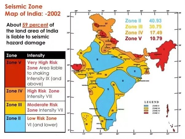
    Earthquake prone zones in India:

  • What is Seismic Noise?

    The seismic noise level has dropped by as much as 50 per cent between March and May due to lockdowns this year, according to researchers.

    Ever heard of space-based monitoring of seismic activities?  This topic creates a scope for potential prelims question…

    What is Seismic Noise?

    • Seismic noise refers to vibrations within the Earth, which are triggered by natural and man-made phenomena like earthquakes, volcanoes and bombs.
    • Seismometers, specialised devices that record ground motions, also capture seismic noise.
    • Everyday human activity — such as road traffic, manufacturing in factories, the sound produced by planes roaring overhead, or simply people walking down the street.
    • The sound signals created by human beings are often referred to as anthropogenic seismic noise.
    • Seismic noise acts almost like background sound for seismologists — it is the unwanted component of signals recorded by a seismometer.

    Variations in noise levels

    • The level of anthropogenic seismic noise recorded varies based on a number of factors.
    • Highly-populated urban areas will generate more vibrations from human activity than less densely populated regions.
    • Timing too plays an important role. The degree of seismic noise is found to be much lower during public holidays.

    Why is this important to record this noise?

    • Due to this, scientists will be able to spot weaker signals.
    • Such small signals tell us about a geological fault making seismic hazard assessment more accurate.
    • This means that scientists will have a better shot at monitoring a whole range of seismogenic behaviour, including the smallest earthquakes or the early signs of a volcanic eruption.
  • [pib] Ravines of Chambal-Gwalior Region

    Union Minister of Agriculture & Farmers’ Welfare held a meeting with World Bank representatives to bring large Ravines of Gwalior–Chambal region under agriculture.

    Try this question for mains:

    Q.What is Badland Topography? Discuss the scope of their utilization as arable land in India.

    What are Ravines?

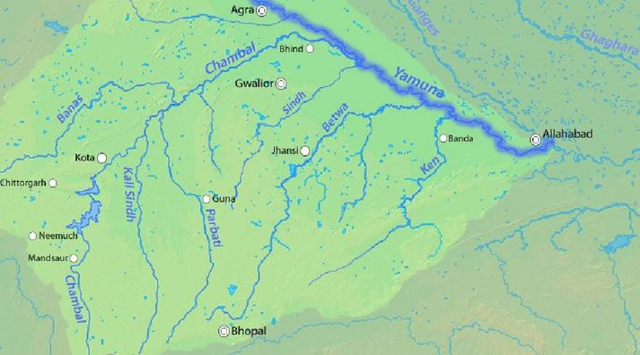
    • Badland topography is a major feature of the Chambal valley is characterized by an undulating floodplain, gullies and ravines.
    • Ravines are a type of fluvial erosional feature and are formed as a result of constant vertical erosion by streams and rivers flowing over semi-arid and arid regions.

    How are they formed?

    • Researchers consider the regional climate as a major factor in the formation of ravines.
    • Climate indeed plays a huge role by supplying the water in the form of rain or snow as well as providing the temperature variations.
    • However, the ravines of Chambal are a bit difficult to be explained solely on climatic terms.
    • The region through which the Chambal River flows does not receive enough rainfall to create ravines that are 60–80 m deep.
    • Researchers have attributed neotectonic activities to the Chambal ravines genesis.

    Other factors

    • It is well known that rivers are full of energy and actively erode in their initial phases and progressively become passive as they attain their base levels.
    • But sometimes, due to tectonic movements, the base level may be lowered further thus energizing the river and reactivating the erosion. This is known as River Rejuvenation.
    • Moreover, wind erosion has also contributed to the formation of Chambal ravines.

    Back2Basics: What are Badlands?

    • Badlands are erosional landforms of highly dissected morphology that are created on soft bedrock in a variety of climate conditions.
    • They develop in arid to semiarid areas where the bedrock is poorly cemented and rainfall is generally heavy and intermittent.
    • The dry, granular surface material and light vegetation are swept from the slopes during showers, leaving the gullies bare.
  • Lonar Lake turned pink due to ‘Haloarchaea’ microbes

    The colour of Lonar lake water in Maharashtra’s Buldhana district turned pink due to a large presence of the salt-loving ‘Haloarchaea’ microbes, a probe carried out by a Pune-based institute has concluded.

    Make a note of all saltwater lakes in India. Few of them are Pulicat, Pangong Tso, Chilika, and Sambhar Lakes etc.

    Haloarchaea’ microbes

    • Haloarchaea or halophilic archaea is a bacteria culture which produces pink pigment and is found in water saturated with salt.
    • The increased salinity and pH facilitated the growth of halophilic microbes, mainly Haloarchaea.
    • Basically, it is the biomass of these microbes and because of that, the surface of the water turned red or pink and as soon as the biomass subsided, the colour disappeared.
    • The scientist said the colour of the lake is now returning to original as the rainy season has kicked in, allowing dilution of the water.
    • Initially, it was thought for the red-pigmented Dunaliella algae due to which the water might have turned pink.
    • Because of that, the salinity and pH/alkalinity levels have also come down and green algae have started growing in the water body.

    About Lonar Lake

    • Lonar Lake, also known as Lonar crater, is a notified National Geo-heritage Monument, saline (pH of 10.5), Soda Lake, located at Lonar in Buldhana district, Maharashtra.
    • It was created by an asteroid collision with earth impact during the Pleistocene Epoch.
    • It is one of the four known, hyper-velocity, impact craters in basaltic rock anywhere on Earth.
    • It sits inside the Deccan Plateau—a massive plain of volcanic basalt rock created by eruptions some 65 million years ago.
    • Its location in this basalt field suggested to some geologists that it was a volcanic crater.