đŸ’„Join UPSC 2027,2028 Mentorship (July Batch) + XFactor Notes & Microthemes PDF

Subject: Geography

  • In news: Cauvery River Dispute

    Why in the News?

    On the Cauvery dispute, Karnataka CM has said that water will be released to Tamil Nadu since the rainfall is adequate, while stressing the Mekedatu Dam’s role in water balance and clean energy.


    Back2Basics: Cauvery River

    • Origin & Course: Rises at Talakaveri, Brahmagiri range (Kodagu, Karnataka); flows ~800 km through Karnataka & Tamil Nadu into the Bay of Bengal.
    • Catchment: Spreads across Karnataka, Tamil Nadu, Kerala, Puducherry.
    • Tributaries: Harangi, Hemavati, Kabini, Suvarnavathi, Bhavani.
    • Nature: Perennial river, sustained by both advancing & retreating monsoons.
    • Protected Areas: Cauvery WLS, Biligirirangan Hills, Pushpagiri, Muthathi, Ranganathittu, Bhimeshwari, Nagarhole, Bandipur.

    About Cauvery Water Sharing Dispute:

    • Colonial Origins: Began in 1892 (Madras Presidency vs Mysore); 1924 Agreement (50 years, expired 1974).
    • Post-Independence: Disputes arose with dam projects by Karnataka (1960s–80s); Supreme Court referred to Cauvery Water Disputes Tribunal (CWDT).
    • Interim Phase: Cauvery River Authority (CRA, 1998) issued temporary orders.
    • CWDT Final Award (2013): Tamil Nadu 419 TMC, Karnataka 270, Kerala 30, Puducherry 7.
    • Karnataka’s Obligation: In normal years, release 177.25 TMC to TN, including 123.14 TMC in SW monsoon.
    • Challenges: Disputes sharpen in weak monsoons, triggering use of a “distress formula”.
    • Legal Basis: Governed by Article 262, Inter-State River Water Disputes Act, 1956; Seventh Schedule entries 17 (State List) & 56 (Union List).

    cauvery

    About Mekedatu Dam Project:

    • Location: Deep gorge at Cauvery–Arkavathi confluence near Kanakapura, Karnataka.
    • Design: Balancing reservoir of ~66 TMC capacity.
    • Objectives: Provide Bengaluru drinking water, generate 400 MW hydropower, regulate flows to TN in drought years.
    • Importance: Karnataka argues it benefits both states by ensuring regulated water release.
    • Opposition: Tamil Nadu objects, fearing reduced downstream availability.
    • Current Status: Karnataka insists on moving ahead, requiring Centre & TN’s clearance.
    [UPSC 2022] Gandikota canyon of South India was created by which one of the following rivers?

    Options: (a) Cauvery (b) Manjira (c) Pennar* (d) Tungabhadra


  • Places in news: Erra Matti Dibbalu

    Why in the News?

    This newscard is an excerpt from a photo published in ‘The Hindu’.

    About Erra Matti Dibbalu:

    • Location: Found between Visakhapatnam and Bheemunipatnam in Andhra Pradesh, stretching 5 km along the coast, with widths ranging from 200 m to 2 km.
    • Meaning: In Telugu, “Erra Matti” means red soil and “Dibbalu” means mounds, describing the reddish sand dunes.
    • Geological Heritage: Listed among the 34 National Geological Heritage Monument Sites of India by the Geological Survey of India (GSI).
    • Formation: Created around 12,000–18,500 years ago through the combined effect of tectonic activity (2.5 million–11,000 years ago), sea-level changes, monsoonal variability, and global climatic shifts.
    • Composition: Derived mainly from Khondalite rocks of the Eastern Ghats hinterland, with the red colour due to oxidation of iron-rich sediments.

    Significance:

    • Geological Value: Acts as a paleo-environment indicator, providing evidence of climate change, sea-level fluctuations, and coastal evolution during the late Quaternary period.
    • Archaeological Importance: Artefacts from Mesolithic and Neolithic periods and sediment layers dating back to the Late Pleistocene epoch have been found here.
    • Conservation Status: Declared a National Geo-heritage Monument (2016) and included in UNESCO’s Tentative List of World Heritage Sites (2025) for global recognition and protection.
    • Unique Landscape: Features badland topography with sand dunes, buried channels, gullies, and dendritic drainage patterns.
    • Rare Formation: Only two other similar red sand dune systems exist globally—the Teri dunes in Tamil Nadu and one site in Sri Lanka.
    [UPSC 2014] When you travel in Himalayas, you will see the following:

    1. Deep gorges 2. U-turn river courses 3. Parallel mountain ranges 4. Steep gradients causing land sliding

    Which of the above can be said to be the evidence for Himalayas being young fold mountains?

    Options: (a) 1 and 2 only (b) 1, 2 and 4 only (c) 3 and 4 only (d) 1, 2, 3 and 4*


  • Freshwater Aquifers found beneath the Atlantic Ocean

    Why in the News?

    The recent discovery of a massive freshwater aquifer beneath the Atlantic shelf opens new possibilities for addressing future global water shortages.

    About the Aquifer:

    • Location: Offshore northeastern U.S., stretching possibly from New Jersey to Maine.
    • Expedition 501: Drilled up to 400 m beneath the seabed, retrieving nearly 50,000 liters of water and thousands of sediment cores.
    • Findings: Fresh and nearly fresh water discovered at both shallower and deeper depths than expected, confirming a vast, pressurized aquifer.
    • Global Context: Similar offshore aquifers are suspected or identified near South Africa, Hawai‘i, Jakarta, and Canada’s Prince Edward Island.

    Possible Origins of the Freshwater:

    • Glacial Meltwater Hypothesis: Ancient ice sheets during lower sea levels allowed meltwater to seep into porous sediments.
    • Connected Aquifer Hypothesis: Modern terrestrial groundwater may still slowly flow offshore through geologic formations.
    • Significance: Determining whether the aquifer is finite fossil water or a renewable source is critical for deciding its usability.

    Significance of the Discovery:

    • Water Security: Could supply a metropolis the size of New York City for centuries, if managed sustainably.
    • Climate Change Resilience: Offers backup options as coastal aquifers face saltwater intrusion and urban demand rises (e.g., Cape Town’s “Day Zero” crisis in 2018).
    • Scientific Impact: First direct, systematic drilling of offshore freshwater for mapping and salinity profiling.
    [UPSC 2021] With reference to the water on the planet Earth, consider the following statements:

    1.The amount of water in the rivers and lakes is more than the amount of groundwater.

    2.The amount of water in polar ice caps and glaciers is more than the amount of groundwater.

    Which of the statements given above is/are correct?

    Options: (a) 1 only (b) 2 only* (c) Both 1 and 2 (d) Neither 1 nor 2


  • Geography uncover why some rivers stay single while others split

    Introduction

    For decades, scientists wondered why some rivers flow as single channels while others split into braided systems. Researchers at the University of California, Santa Barbara (UCSB), after studying 84 rivers over 36 years using satellite data, have uncovered the mechanism. Their findings resolve a geomorphological puzzle and offer fresh insights for managing rivers amid climate change, rising floods, and human interventions.

    Why is this discovery significant?

    The UCSB study shows that erosion, not equilibrium, drives multi-threading. Single-thread rivers balance erosion and deposition, while braided rivers erode banks faster than they deposit, making them unstable. This overturns earlier models assuming fixed depth and width. In an era of extreme weather, such insights are vital for flood prediction, ecosystem restoration, and sustainable infrastructure.

    Understanding the dynamics of single-thread and multi-thread rivers

    1. Single-thread rivers: They maintain equilibrium between bank erosion and bar accretion, ensuring stable width.
    2. Multi-thread rivers: They are characterised by imbalance, where erosion exceeds deposition, causing channels to widen and split repeatedly.
    3. Example: Brahmaputra’s braided channels erode laterally at a rapid pace, making them inherently unstable.

    Scientific breakthrough in decoding river channel behavior

    1. Data analysed: 84 rivers across climates and terrains, spanning 36 years (1985–2021).
    2. Technology used: Particle Image Velocimetry (PIV) on satellite images, generating 4 lakh+ measurements of erosion and accretion.
    3. Outcome: Identification of patterns showing why some rivers remain stable and others split into multiple channels.

    The ecological role of vegetation in shaping river morphology

    1. Earlier belief: Vegetated banks were considered essential for meandering rivers.
    2. Stanford study finding: Vegetation alters river bend migration:
    3. Vegetated bends → Move outward, creating levees, limiting sinuosity.
    4. Unvegetated bends → Drift downstream, forming different sedimentary deposits.
    5. Implication: River evolution is not only hydrological but also ecological.

    Implications for India’s river systems: Ganga and Brahmaputra in focus

    • Case studies: Ganga near Patna, Farakka, Paksey; Brahmaputra near Pandu, Pasighat, Bahadurabad.
    • Findings: Multi-thread rivers like Brahmaputra are inherently unstable due to rapid lateral erosion.
    • Problem: Artificial confinement by embankments has worsened risks in India.
    • Implication: Flood forecasting models (rating curves) need frequent updates as channel shapes shift.

    Nature-based solutions and strategies for sustainable river management

    1. Remove artificial embankments
    2. Restore natural floodplains
    3. Create vegetated buffer zones along banks
    4. Reactivate abandoned channels
    5. Build wetlands in braided sections
    6. Advantages: Lower cost of restoration, better flood absorption, reduced disaster risk.

    Conclusion

    The new understanding of why rivers split reshapes our approach to flood management, river restoration, and ecological conservation. For India, where rivers like the Ganga and Brahmaputra are lifelines but also sources of recurrent floods, this research is a wake-up call. Emphasising natural solutions over artificial confinement could pave the way for sustainable water governance in the climate change era.

    PYQ Relevance

    [UPSC 2016] Major cities of India are becoming more vulnerable to flood conditions. Discuss.

    Linkage: The recent UCSB study highlights that multi-thread rivers like the Ganga and Brahmaputra are inherently unstable because erosion outpaces deposition, causing channels to split and shift rapidly. In India, this instability is often worsened by human interventions such as embankments, damming, and encroachment, which artificially confine rivers. As these channels change, urban centres located along floodplains (Patna, Guwahati, Kolkata, etc.) become highly flood-prone. The research also suggests that relying on outdated models assuming rivers are stable leads to poor flood prediction in cities. Thus, insights from this study strengthen the argument that urban flooding in India is not only due to unplanned urbanisation but also due to the geomorphological instability of river systems and flawed management practices.

  • Deadly Earthquake in Afghanistan

    Why in the News?

    A powerful earthquake in Afghanistan killed at least 800 people and injured thousands, highlighting the country’s extreme vulnerability to seismic hazards.

    Deadly Earthquake in Afghanistan

    Why is Afghanistan so prone to Earthquakes?

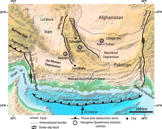
    • Geological Setting: Afghanistan lies in the Hindu Kush mountains, part of the Alpide Belt, the world’s second most seismically active belt after the Circum-Pacific.
    • Tectonic Origin: The Alpide Belt was formed by the closure of the Tethys Ocean, following the collision of the African, Arabian, and Indian Plates with the Eurasian Plate.
    • Ongoing Collision: The Indian Plate’s continued movement into the Eurasian Plate builds mountain ranges (Himalayas, Hindu Kush) and drives strong seismic activity.
    • Seismic Characteristics: Afghanistan experiences both shallow-focus earthquakes (0–70 km depth) causing major destruction and rare deep-focus quakes (up to 200 km) unique to the Hindu Kush.
    • Fault Structures: Major faults occur where the Indian and Eurasian Plates meet, making Afghanistan heavily fractured and highly vulnerable to tremors.

    Where do Afghanistan’s Earthquakes occur?

    • Hindu Kush Region (Northern Afghanistan): Produces both shallow and deep-focus quakes due to the Indian Plate’s lithosphere sinking into the mantle, making it one of the world’s most unique seismic zones.
    • Sulaiman Range (SE Afghanistan & Western Pakistan): Known for shallow, thrust fault quakes, often destructive at the surface.
    • Main Pamir Thrust Zone: Another hotspot for shallow, surface-level earthquakes that cause high damage.
    • Overall Vulnerability: These regions together make Afghanistan one of the most earthquake-prone countries, with repeated deadly events since the 1990s.
    [UPSC 2023] Consider the following statements:

    1. In a seismograph, P waves are recorded earlier than S waves.

    2. In P waves, the individual particles vibrate to and fro in the direction of waves propogation whereas in S waves, the particles vibrate up and down at right angles to the direction of wave propagation.

    Which of the statements given above is/are correct?

    Options: (a)  1 only (b) 2 only (c) Both 1 and 2 * (d) Neither 1 nor 2


  • Mount Etna Eruption

    Why in the News?

    Mount Etna has erupted again after its recent eruption in June.

    About Mount Etna:

    • Location: Situated on the east coast of Sicily, Italy, near the city of Catania.
    • Type: Mount Etna is a stratovolcano (also called a composite volcano), which is formed from layers of hardened lava, volcanic ash, and rocks.
    • Height: It stands at approximately 3,300 meters, making it the tallest volcano in Europe south of the Alps.
    • Recognition: Declared a UNESCO World Heritage Site in 2013, with documented volcanic activity for at least 2,700 years.
    • Eruption Record: Etna is almost constantly active. Notable eruptions have occurred in 1400 B.C., 1669, 2001, 2018, 2021, 2024, and 2025.
    • Volcanic Activity Style: Known for Strombolian and effusive eruptions, with occasional Plinian eruptions (rare and more explosive).

    Reasons Behind the Eruption:

    • Nature of Eruption: The eruption is classified as either Strombolian or possibly Plinian, depending on interpretation:
      • Strombolian Eruption: Characterized by moderate explosive bursts, caused by gas bubbles in magma suddenly bursting at the surface.
      • Plinian Eruption: Some volcanologists suggest this classification due to the large ash column that may have reached the stratosphere.
    • Eruption Trigger: The eruption likely began due to pressure buildup from gas within the magma chamber, leading to collapse of the southeast crater and lava flows.
    [UPSC 2014] Consider the following geological phenomena:

    1. Development of a fault

    2. Movement along a fault

    3. Impact produced by a volcanic eruption

    4. Folding of rocks Which of the above cause earthquakes?

    Options: (a) 1, 2 and 3 (b) 2 and 4 (c) 1, 3 and 4 (d) 1, 2, 3 and 4*


  • Challenges of Monsoon Variability and Disaster Preparedness

    Introduction

    Heavy rains in August 2025 have wreaked havoc across North India, Himachal Pradesh cut off, Jammu and Kashmir reporting over 40 deaths, Punjab’s farmland submerged, and the Yamuna swelling in the capital. The floods highlight the increasing unpredictability of the southwest monsoon, where rainfall comes in concentrated bursts rather than spread across weeks. Beyond the immediate tragedy, this points to systemic governance challenges, unplanned infrastructure in fragile zones, inadequate early warning systems, and a reactive rather than preventive disaster management model.

    Increasing unpredictability of the monsoon

    1. Erraticism of rainfall: Concentrated bursts replace evenly spread rains, overwhelming slopes, rivers, and cities.
    2. Amplified erosion: Short, intense rain accelerates slope destabilisation in Himalayas.
    3. Recurring phenomenon: Evidence now suggests such rainfall patterns are no longer exceptional but likely regular.

    Fragility of Himalayan ecosystems and their weakening

    1. Deforestation and clearance: Forest cover removal and road-widening continue unchecked.
    2. Slope destabilisation: Lack of slope-safe engineering increases landslide risks.
    3. Shrinking catchments: Reduced buffering capacity heightens chances of slope failure and siltation downstream.

    Insufficiency in disaster preparedness

    1. Early warning gaps: Despite better forecasts, reliable ground-level alerts are absent.
    2. Relief over resilience: Agencies mobilise post-damage; pre-positioned supplies and community drills are missing.
    3. Reactive model: Each disaster treated as unforeseeable, ignoring repeated expert warnings.

    Policy choices aggravating vulnerabilities

    1. Strategic projects: Roads and urban expansion pursued in unstable landscapes.
    2. Poor compensatory afforestation: Quality of replanted forests does not match original ecological value.
    3. Climate-resilient infrastructure lag: Development focus prioritises speed over sustainability.

    Shifts required in disaster governance

    1. Shift to preventive strategies: Focus on reducing vulnerabilities before disasters occur.
    2. Systematic preparedness: Regular drills, community participation, and pre-emptive relief stocks.
    3. Balanced growth: Infrastructure that respects ecological fragility and integrates climate resilience.

    Conclusion

    The 2025 floods across North India are not isolated accidents but part of a pattern of climate-driven extreme weather. Treating each calamity as “unprecedented” delays learning and perpetuates cycles of loss. Building resilience means moving beyond post-disaster relief to preventive strategies: sustainable infrastructure, landslide mitigation, community drills, and early-warning systems. Unless governance shifts from reaction to anticipation, monsoon seasons will continue to leave trails of destruction.

    PYQ Relevance

    [UPSC 2019] Disaster preparedness is the first step in any disaster management process. Explain how hazard zonation mapping will help disaster mitigation in the case of landslides.

    Linkage: The 2025 North India floods highlight how slope destabilisation and unchecked construction in Himalayan States amplify landslide risks. Hazard zonation mapping could have guided slope-safe engineering, restricted high-risk land use, and improved early warning. Thus, it directly connects preparedness to mitigation, aligning with the UPSC 2019 question.

  • Rivers, Dams, and Headworks of Punjab

    Why in the news?

    Floods hit Punjab villages due to heavy rain in Himachal, high dam discharges (Bhakra, Pong, Ranjit Sagar), and regulated headworks flow.

    Rivers, Dams, and Headworks of Punjab

    About the Rivers, Dams, and Headworks of Punjab:

    River Origin & Entry into Punjab Major Dam (Location & Key Facts) Headworks & Functions
    Sutlej Origin: Rakshastal Lake (Tibet); enters India at Shipki La (HP); enters Punjab at Rupnagar; joins Beas at Harike, then Chenab in Pakistan. Bhakra Dam (near Nangal, HP–Punjab border).

    One of India’s highest gravity dams; reservoir = Gobind Sagar Lake; irrigation + hydropower.

    Ropar: Feeds Sirhind & BML canals (Punjab + Haryana).

    Harike: Diverts Sutlej–Beas water to Rajasthan & Punjab canals.

    Hussainiwala: Feeds Bikaner & Eastern Canals (Punjab + Rajasthan).

    Beas Origin: Beas Kund (Rohtang Pass, HP); enters Punjab near Mukerian (Hoshiarpur); flows via Hoshiarpur, Gurdaspur, Tarn Taran, Amritsar. Pong Dam (Maharana Pratap Sagar), HP (Kangra).

    Major irrigation + power dam; supplies Harike.

    Harike: Regulates Beas + Sutlej water; feeds Rajasthan & Punjab canals.
    Ravi Origin: Bara Banghal (Rohtang Pass, HP); enters Punjab near Pathankot; flows via Pathankot, Gurdaspur;

    Enters Pakistan and joins Chenab.

    Ranjit Sagar Dam (Thein Dam), Pathankot (Punjab–J&K border). Irrigation + hydropower. Madhopur: Feeds UBDC canal (Punjab).

    Madhopur–Beas Link: Transfers surplus Ravi to Beas before Pakistan.


    [UPSC 2021] With reference to the Indus river system, among the following four rivers, one of them joins the Indus directly:

    Options: (a) Chenab (b) Jhelum (c) Ravi (d) Sutlej*


  • Mawsynram and Cherrapunji no longer Wettest Places in India

    Why in the News?

    Cherrapunji and Mawsynram have recorded about 50% below normal rainfall this year.

    About the Wettest Places in India:

    • Cherrapunji (Sohra, East Khasi Hills, Meghalaya) and Mawsynram (same district) are globally known as the wettest places on Earth.
    • Average annual rainfall: ~11,000–12,000 mm.
    • World record events:
      • Highest annual rainfall: Mawsynram holds the record for highest annual rainfall.
      • Heaviest rainfall: Cherrapunji recorded 2,493 mm in 48 hours (June 1995), one of the heaviest rainfalls ever documented.

    Comparative Rainfall Data (for 2025 Monsoon Season):

    • Cherrapunji (Sohra): ~3,500 mm (≈50% deficit from normal).
    • Surlabbi (Kodagu, Karnataka): ~7,300 mm (highest in India this year).
    • Tamhini (Maharashtra): 5,788 mm (June–July).
    • Trend: At least 32 stations across India received more rainfall than Cherrapunji in June–July 2025.
    • Historical Low for Sohra: 5,401 mm in 1962 → 2025 may break this record if deficit continues.

    Why Mawsynram /Cherrapunji receive such high rainfall?

    • Geographical Location: Lies on the southern slopes of the Khasi Hills, directly facing the Bay of Bengal branch of the southwest monsoon.
    • Orographic Effect: Moist monsoon winds hit the steep hills, rise rapidly, and cause heavy orographic rainfall.
    • Monsoon Duration: Receives rainfall almost continuously from June to September, with frequent cloudbursts.
    • Topography: Steep hills + valleys act as a trap for moisture-laden winds, leading to intense rainfall concentration.
    • Climatic Setting: Part of the Humid Subtropical/Monsoonal climate zone of Northeast India, with high moisture inflow.
    [UPSC 2015] Consider the following States:

    1. Arunachal Pradesh 2. Himachal Pradesh 3. Mizoram

    In which of the above States do ‘Tropical Wet Evergreen Forests’ occur?

    Options: (a) 1 only (b) 2 and 3 only (c) 1 and 3 only* (d) 1, 2 and 3


  • African Union (AU) and the Mercator Map Debate

    Why in the News?

    The African Union (AU) has endorsed the Correct the Map campaign to replace the 16th-century Mercator projection with more accurate maps.

    African Union (AU) and the Mercator Map Debate

    About the African Union (AU):

    • Establishment: Formed in 2002, replacing the Organisation of African Unity (1963).
    • Membership: 55 African countries.
    • Headquarters: Addis Ababa, Ethiopia.
    • Vision: “An Integrated, Prosperous, and Peaceful Africa, driven by its own citizens.”
    • Agenda 2063: Blueprint for socio-economic growth and continental unity.
    • Main Organs: Assembly, Executive Council, AU Commission, Peace and Security Council.

    What is a Mercator Map?

    • Creation: Designed in 1569 by Gerardus Mercator.
    • Projection: Cylindrical map with straight longitude and latitude lines intersecting at 90°.
    • Purpose: Enabled sailors to plot straight-line courses for compass navigation.
    • Adoption: Became the standard map in schools, atlases, and wall charts by the 19th century.

    Issues with the Mercator Map:

    • Distortion: Enlarges high-latitude regions (Europe, Russia, North America) while shrinking Africa and South America.
    • Example: Greenland appears equal to Africa, though Africa is ~14 times larger.
    • Colonial Bias: Reinforced Western dominance narratives and downplayed Africa’s size and importance.
    • Impact: Supported marginalisation and exploitation during colonialism.
    • Alternatives: Gall-Peters (1970s) and Equal Earth (2018) projections show continents in correct proportion.
    • AU Stand: Advocates replacing Mercator maps to restore Africa’s rightful global image.
    [UPSC 2024] The longest border between any two countries in the world is between:

    Options: (a) Canada and the USA * (b) Chile and Argentina (c) China and India (d) Kazakhstan and Russian Federation