đŸ’„Join UPSC 2027,2028 Mentorship (July Batch) + XFactor Notes & Microthemes PDF

Subject: Geography

  • 1950 Assam Earthquake and Future Seismic Risks in the Himalayas

    Why in the News?

    75 years ago on August 15, 1950, a magnitude 8.6 earthquake — the strongest recorded on land — struck Northeast India and surrounding regions.

    1950 Assam Earthquake and Future Seismic Risks in the Himalayas

    About the Earthquake:

    • Magnitude: 8.6, the strongest recorded earthquake on land.
    • Impact Area: Tremors lasted 4–8 minutes, felt over 3 million sq. km in India, Myanmar, Bangladesh, Tibet, and South China.
    • Casualties: Over 1,500 deaths in India and 4,000+ in Tibet; heavy livestock losses and infrastructure destruction.
    • Secondary Disasters: Triggered landslides blocking rivers, followed by devastating flash floods.

    Geological and Tectonic Setting:

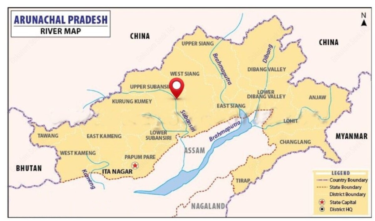
    • Epicentre: 40 km west of Rima (Zayu), near India–Tibet border in the Mishmi Hills.
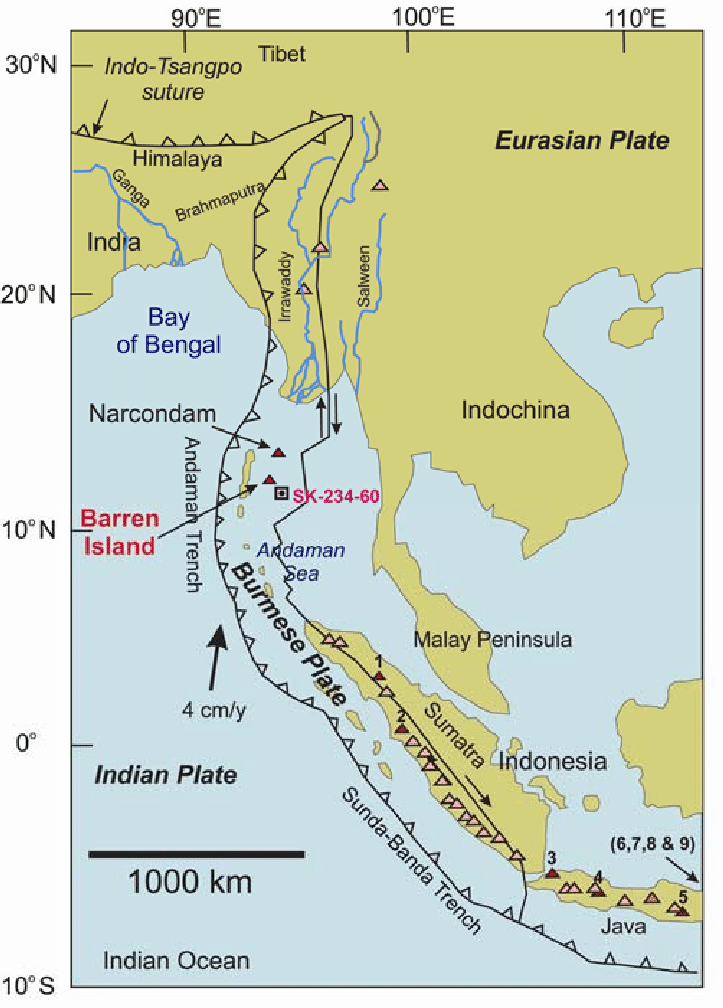
    • Tectonic Context: Located on Indian–Eurasian Plate boundary within Eastern Himalayan Syntaxis (EHS), influenced by the Sunda Plate.
    • Fault Type: Strike-slip motion with thrust faulting — atypical for Himalayan quakes.
    • Plate Convergence: Eastern Himalayas converge at 10–38 mm/year vs. ~20 mm/year elsewhere.
    • Aftershocks: Indicated activation of multiple faults from the Syntaxial bend to Himalayan thrust faults in Arunachal Pradesh.

    Lessons and Future Risks:

    • Magnitude Potential: Confirms Himalayan segments can produce ≄8.6 magnitude events.
    • Central Himalayan Risk: Identified as likely site for similar future quake.
    • Vulnerability Today: Increased due to urbanisation and large infrastructure in seismic zones.
    • Infrastructure Safety: Necessitates strict norms for dams and high-risk projects in Eastern Himalayas.
    • Preparedness: Highlights need for seismic hazard mapping and disaster readiness.
    [UPSC 2024] Consider the following statements:

    1. In a seismograph, P waves are recorded earlier than S waves.

    2. In P waves, the individual particles vibrate to and fro in the direction of waves propogation whereas in S waves, the particles vibrate up and down at right angles to the direction of wave propagation. Which of the statements given above is/are correct?

    Options: (a) 1 only (b) 2 only (c) Both 1 and 2* (d) Neither 1 nor 2


  • In news: Dardanelles Strait

    Why in the News?

    The Dardanelles Strait in northwestern Turkey has been temporarily closed to maritime traffic due to forest fires near Canakkale, prompting evacuations and firefighting operations.

    About Dardanelles Strait:

    • Location: Northwestern Turkey; separates Gallipoli Peninsula (Europe) from Troad/Biga Peninsula (Asia).
    • Connection: Links Aegean Sea → Sea of Marmara → Bosporus → Black Sea.
    • Dimensions: Length 61 km, width 1.2–6.5 km, average depth 55 m, max depth 103 m.
    • Historical Name: Hellespont, named after mythical princess Helle; current name from ancient city of Dardanus.
    • Currents: Surface current flows from Sea of Marmara to Aegean; saline undercurrent in reverse.
    • Ports: Gallipoli, Eceabat, Çanakkale.

    Strategic & Economic Importance:

    • Part of Turkish Straits system with Bosporus; only maritime link between Black Sea and Mediterranean.
    • Critical for Black Sea nations’ trade (Russia, Ukraine, Bulgaria, etc.).
    • Major route for grain, oil, energy shipments from Black Sea region to global markets.
    • Governed by Montreux Convention (1936) for warship passage.
    • Vital for NATO naval strategy and maritime security.
    [UPSC 2008] Through which one of the following Straits does a tunnel connect the United Kingdom and France?

    Options: (a) Davis Strait (b) Denmark Strait (c) Strait of Dover* (d) Strait of Gibraltar


  • Sleeping disasters: Cloudbursts

    Cloud Burst:

    A cloudburst is an extremely intense, localized shower, defined by the India Meteorological Department (IMD) as at least 100 mm of rain within one hour over 10 sq km. These events occur due to deep, rapid atmospheric uplift over steep terrain, typical of high-altitude Himalayan regions. They can trigger sudden flash floods and landslides, devastating communities in mountainous regions. The term does not refer to a literal bursting cloud but to rapid precipitation from cumulonimbus clouds, sometimes accompanied by thunder or hail.

    Why was the recent Uttarkashi Disaster not a Cloudburst?

    1. Despite initial reports, Uttarkashi district did not record any cloudburst-level rainfall. Actual rainfall was only light to moderate, ranging from 8 mm to 43 mm on Aug 5, far below the 100 mm/hour threshold
    2. The region lacked weather radar coverage at that altitude, so precise measurements were unavailable and the “cloudburst” classification was premature.
    3. Uttarkashi’s steep, rugged topography, with narrow valleys and loose debris, turned the soil into unstable slopes.
    4. A debris-laden flood, possibly triggered by a glacial lake burst, glacier collapse, or landslide, raced downstream as mud and silt-laden water to hit Dharali village violently.

    Reasons for occurrence of cloudbursts:

    1. Cloudbursts happen when warm, moist air quickly rises over mountains, cools down, and turns into heavy rain. This process, called orographic lift, causes the air to release a large amount of rain in a short time.
    2. Sudden mixing of warm and cold air
    3. Strong upward air movement (convection) and high moisture in the air at high altitudes

    Why Do Cloudbursts Happen In The Hills?

    1. Topography: Mountains force moist air to rise rapidly, causing sudden cooling and condensation.
    2. Weather Conditions: Warm air with high moisture content meets cooler air at high altitudes. This results in intense convection and localised torrential rain.

    Can cloudbursts be forecast?

    1. The India Meteorological Department (IMD) forecasts rainfall events well in advance, but it does not predict the quantum of rainfall,  in fact, no meteorological agency does.
    2. IMD gives general rainfall forecasts (light, heavy, very heavy), but not exact amounts.
    3. These forecasts are for large areas like districts or states, not specific locations.
    4. Cloudbursts can’t be predicted exactly due to tech limitations and lack of dense instruments.
    5. However, warnings for very heavy rain (which may lead to cloudburst-like events) are given 6–12 hours in advance.

    Impacts of cloud burst:

    1. Flash Floods: The most immediate and destructive impact is the rapid overflowing of rivers and streams, leading to widespread flooding of low-lying areas.
    2. Landslides and Mudslides: The excessive water saturates the soil on slopes, leading to the rapid downward movement of earth, rocks, and debris, causing significant destruction and posing a threat to human lives and infrastructure.
    3. Soil Erosion: The intense rainfall can wash away topsoil, degrading the land and negatively affecting agriculture.
    4. Land Subsidence: The weakening of the ground due to excessive water absorption can cause the sudden sinking or settling of the Earth’s surface
    5. Loss of Life: The suddenness and intensity of cloudbursts often leave little time for evacuation.
    6. Damage to Infrastructure: Roads, bridges, homes, and public utilities can be severely damaged or completely destroyed.

    While the term “cloudburst” often evokes images of catastrophic floods and landslides, it’s crucial to adopt a nuanced approach, avoiding knee-jerk reactions and recognizing that not all instances of heavy rainfall are cloudbursts. While the unpredictable ferocity of cloudbursts remains a formidable challenge, a proactive blend of scientific innovation, infrastructure resilience, and community-centric preparedness offers the compass to navigate their escalating threat, particularly in fragile ecosystems like the Himalayas.

  • Does Rain make Ocean Water more Buoyant?

    Why in the News?

    New research shows that rain can reduce ocean buoyancy and stabilize tropical waters, challenging the belief that rain always enhances mixing.

    Does Rain make Ocean Water more Buoyant?

    About Buoyancy:

    • What is it: It is the upward force exerted by a fluid (e.g., water) on an object submerged in it.
      • It determines whether an object floats, sinks, or stays suspended.
    • Buoyancy in Oceans: It depends on density differences in water.
      • Lighter water above → unstable → mixing happens.
      • Heavier water above → stable → mixing stops.
    • Buoyancy Flux: Measures changes in buoyancy at the ocean surface over time.
      • Freshwater from rain → makes surface lighter → positive flux → promotes mixing.
      • Heat loss → cools surface → makes water denser → negative flux → resists mixing.

    Key Findings of the Study:

    • Light Rain (0.2–4 mm/hr): Often leads to positive buoyancy flux → supports ocean mixing.
    • Heavy Rain:
      • Usually results in negative buoyancy flux → surface becomes stable.
      • Caused by cold pools that enhance heat loss.
    • Day vs. Night Effect:
      • Night: Rain destabilizes surface → mixing increases.
      • Day: Rain promotes stability → due to added heat loss from sunlight blockage.
    • Geographical Insights:
      • Cold Rain Zones (Western Pacific, Indian Ocean): More stabilization.
      • Hot Rain Zones (Central Pacific): More prone to mixing.

    Significance of the Study

    • Scientific Implications:
      • Refutes the general belief that rain always increases buoyancy.
      • Shows rain can both stabilize or destabilize the ocean surface depending on conditions.
    • Climate Relevance:
      • Ocean mixing is key to heat, carbon, and nutrient cycling.
      • Misreading rainfall’s role can skew climate and weather models.
    • Practical Impact:
      • Improves forecasting accuracy in oceanography and climate science.
      • Aids in understanding the climate-ocean feedback loop more precisely.
    [UPSC 2020] With reference to Ocean Mean Temperature (OMT), which of the following statements is/are correct?

    1. OMT is measured up to a depth of 26°C isotherm which is 129 meters in the southwestern Indian Ocean during January — March.

    2. OMT collected during January — March can be used in assessing whether the amount of rainfall in monsoon will be less or more than a certain long-term mean.

    Select the correct answer using the code given below:

    Options: (a) 1 only (b) 2 only* (c) Both 1 and 2 (d) Neither 1 nor 2


  • Tsunami Waves triggered by quakes in Kamchatka Peninsula

    Why in the News?

    An 8.8 magnitude earthquake hit off Russia’s Kamchatka Peninsula, triggering 16-foot tsunamis that reached Hawaii and northern California in the US.

    About Earthquakes:

    • Overview: Sudden ground shaking caused by release of stored energy in Earth’s crust due to tectonic stress.
    • Cause: Occurs when tectonic plates slip at fault lines where stress had built up due to friction.
    • Seismic Waves: Energy travels as:
      • Primary Waves (P-waves): Fastest, compressional.
      • Secondary Waves (S-waves): Slower, shear motion.
    • Key Terms:
      • Focus (Hypocenter): Underground origin point.
      • Epicenter: Surface point directly above the focus.
    • Measurement:
      • Magnitude: Energy released (Richter Scale, logarithmic).
      • Intensity: Observed ground shaking (varies by location).
      • Seismograph: Records seismic wave activity.

    How Earthquakes Trigger Tsunamis?

    • Underwater Epicenter: Must occur beneath oceans to displace water.
    • Shallow Depth: Quakes at <70 km transfer energy more efficiently to water surface.
    • Reverse Faulting: One tectonic plate pushes over another, vertically shifting the seafloor.
    • Rapid Displacement: Sudden seafloor uplift/downthrust generates massive water waves.
    • High Magnitude: Quakes >7.0 (especially >8.0) likely to trigger tsunamis.

    About the Kamchatka Region:

    • Overview: Russian Far East; borders the North Pacific Ocean.
    • Tectonic Zone: Sits on the Kuril-Kamchatka Trench—Pacific Plate subducting under Okhotsk Plate at ~86 mm/year.
    • Seismic Hotspot: Historical major quakes in 1841, 1923, 1952, 2006, and 2020.
    • Ring of Fire: Part of the 40,000 km Pacific Ring of Fire , known for quakes and volcanoes.
    • 2025 Earthquake:
      • Depth:3 km (shallow)
      • Impact: Triggered tsunami waves up to 16 ft—one of the strongest earthquakes since 1900.
    [UPSC 2004] Consider the following geological phenomena:

    1. Development of a fault 2. Movement along a fault 3. Impact produced by a volcanic eruption 4. Folding of rocks

    Which of the above cause earthquakes?

    Options: (a) 1, 2 and 3 (b) 2 and 4 (c) 1, 3 and 4 (d) 1, 2, 3 and 4*


  • Cuvette Centrale: World’s Largest Tropical Peatland Complex

    Why in the News?

    The Democratic Republic of the Congo (DRC) has launched oil exploration over 124 million hectares of the Cuvette Centrale peatlands raising global ecological risk.

    About the Cuvette Centrale Peatland Complex:

    • Location: Central Congo Basin, spanning the Democratic Republic of the Congo and the Republic of Congo.
    • Size: Covers approximately 145,000–167,600 sq. km—larger than England and about 10% of the Congo Basin.
    • Peat Coverage: Around 40% of the region is underlain by peat—formed over 10,000 years due to flat terrain, rainforest climate, and slow-moving water.
    • Landscape: Features a mosaic of seasonal lakes, floating prairies, swamp forests, rivers, and grasslands.
    • Global Status: The world’s largest near-contiguous tropical peatland complex.

    Ecological Significance:

    • Carbon Storage: Holds about 30–30.6 gigatonnes of carbon—
      • Equal to 3 years of global fossil fuel emissions.
      • Nearly 15 years of U.S. emissions.
      • About 28% of global tropical peat carbon stock.
    • Climate Impact: Acts as a major carbon sink, critical for regulating global temperatures and mitigating climate change.
    • Biodiversity: Habitat for forest elephants, lowland gorillas, and rare plant species.
    • Local Importance: Sustains indigenous livelihoods and maintains regional water cycles.
    • Conservation Status: Recognized as a transnational Ramsar wetland site, highlighting its international ecological value.
    [UPSC 2024] One of the following regions has the world’s largest tropical peatland, which holds about three years’ worth of global carbon emissions from fossil fuels, and the possible destruction of which can exert a detrimental effect on the global climate. Which one of the following denotes that region?

    Options: (a) Amazon Basin (b) Congo Basin* (c) Kikori basin (d) Rio De La Plata Basin


  • Places in news: Bitra Island

    Why in the News?

    The Lakshadweep administration has proposed the acquisition of Bitra Island, the smallest inhabited island in the archipelago, for national defence purposes.

    bitra

    About Bitra Island:

    • Location: Situated in the Arabian Sea; part of the Amindivi subgroup of the Lakshadweep archipelago
    • Distance from Mainland: ~483 km west of Kochi  
    • Land Area: 0.10–0.18 square kilometres
    • Population: ~271–350 (as of 2025)
    • Language and Livelihood
      • Languages Spoken: Malayalam, Mahl, and English
      • Economic Activities: Fishing, coconut farming, and emerging ecotourism (birdwatching, snorkeling, diving)
    • Climate:
      • Type: Tropical monsoon (similar to Kerala)
      • Temperature Range: 25–35°C
      • Annual Rainfall: ~1600 mm
      • Monsoon Season: Mid-May to mid-September; sea access is limited
    • Historical and Cultural Significance:
      • History: Populated around 1945
      • Pilgrimage Site: Hosts a shrine to Arab saint Malik Mulla

    Strategic Importance:

    • Location: Close to key international shipping lanes in the Arabian Sea
    • Surveillance Advantage: Ideal point for maritime monitoring
    • Military Utility: Suitable for naval installations and coastal defence
    • Maritime Awareness: Enhances India’s preparedness in the western seaboard
    [UPSC 2014] Which one of the following pairs of islands is separated from each other by the ‘Ten Degree Channel’?

    Options: (a) Andaman and Nicobar* (b) Nicobar and Sumatra (c) Maldives and Lakshadweep (d) Sumatra and Java


  • Wind Stilling Effect in the Indo-Gangetic Plain (IGP)

    Why in the News?

    A satellite-based study (2003–2020) of 141 Indian cities revealed a surprising aerosol pattern — southern cities act as pollution hotspots, while many northern cities form ‘clean islands’ due to a phenomenon called the Wind Stilling Effect.

    Key Highlights of the Study:

    • Conducted by: The Indian Institute of Technology Bhubaneswar.
    • Method: Used high-resolution aerosol optical depth data to track pollution.
    • Focus: Examined how urbanisation interacts with natural and transported pollution.
    • Surprising Insight: Many northern cities were not major aerosol hotspots, contrary to assumptions.
    • Classification of Cities: Two categories based on aerosol levels relative to surrounding areas:
      • Urban Aerosol Pollution Islands-
        • Location: Predominantly in southern and southeastern India.
        • Characteristics: Cities had higher aerosol levels than nearby rural surroundings.
        • Pollution Source: Mostly local emissions from vehicles, construction, and industries.
        • Absence of External Influence: Minimal contribution from long-range dust or biomass burning.
      • Urban Aerosol Clean Islands-
        • Location: Observed in northwestern India and the Indo-Gangetic Plain.
        • Pattern: Cities had lower aerosol levels than nearby upwind (southwest) areas.
        • Mechanism: Incoming pollutants were blocked or deflected, creating a “clean island” effect.
        • Downwind Evidence: Northeast (downwind) sides showed equal or lower aerosol levels compared to city centres.

    About the Wind Stilling Effect:

    • Overview: A phenomenon where dense urban infrastructure reduces surface wind speed, altering local airflow.
    • Barrier Formation: Slowed winds create atmospheric stagnation zones, especially on the upwind side.
    • Pollution Blocking: Long-range pollutants like Thar Desert dust or biomass smoke are slowed or blocked.
    • Misleading Cleanliness: Cities appear cleaner not due to lower emissions, but due to pollution deflection.
    • Seasonality: Most evident during the pre-monsoon season, when dust transport is high and cloud cover is minimal.
    [UPSC 2010] If there were no Himalayan ranges, what would have been the most likely geographical impact on India ?

    1. Much of the country would experience the cold waves from Siberia. 2. Indo-gangetic plain would be devoid of such extensive alluvial soils. 3. The pattern of monsoon would be different from what it is at present.

    Which of the statements given above is/are correct ?

    Options: (a) 1 only (b) 1 and 3 only (c) 2 and 3 only (d) 1, 2 and 3*


  • [22nd July 2025] The Hindu Op-ed: Water, energy demand spotlights risk of human-induced quakes 

    PYQ Relevance:

    [UPSC 2020] Discuss the geophysical characteristics of Circum-Pacific Zone.

    Linakge: This question is about a region known for earthquakes and volcanoes. The article mainly talks about quakes caused by human activity but also mentions that these usually happen in places already on fault lines or where tectonic plates are shifting—areas like the Circum-Pacific. So, it’s important to understand these natural zones when looking at how human actions might trigger earthquakes.


    Mentor’s Comment:  Human-induced earthquakes are increasingly drawing scientific and public attention, as research shows that human activities like groundwater extraction, dam construction, and fracking can trigger or accelerate seismic activity, particularly in tectonically sensitive regions such as Delhi-NCR, the Western Ghats, and parts of Maharashtra and Kerala.

    Today’s editorial analyses the Issues related to Human-induced earthquakes in India. This topic is important for GS Paper I (Geography), GS Paper II (Governance) and  GS Paper III (Disaster Management) in the UPSC mains exam.

    _

    Let’s learn!

    Why in the News?

    Recent studies in India have highlighted a correlation between excessive groundwater depletion and increased seismic events, especially in Delhi.

    What are human-induced earthquakes?

    • These are earthquakes triggered by human activities rather than natural tectonic movements. Activities like mining, groundwater extraction, building dams, and fracking disturb the earth’s crust, causing seismic activity. Over 700 human-induced quakes have been recorded globally in the last 150 years.


    How do activities like groundwater extraction and dams trigger quakes in India?

    • Groundwater Depletion Weakens Crustal Stability: Excessive extraction of groundwater reduces pore pressure, leading to a shift in stress within the earth’s crust. Eg: In Delhi-NCR, increased seismic activity between 2003–2012 has been linked to excessive groundwater loss.
    • Reservoir-Induced Seismicity (RIS): The weight of large reservoirs exerts additional pressure on underlying faults, triggering quakes. Eg: The 1967 Koynanagar earthquake (magnitude 6.3) was linked to the Koyna Dam in Maharashtra.
    • Water Infiltration into Fault Zones: Water from reservoirs or excessive irrigation can seep deep into fault lines, lubricating them, and making them more likely to slip. Eg: Seismic tremors near Mullaperiyar Dam in Kerala are suspected to be induced due to water infiltration in a seismically sensitive region.
    • Load Variation Due to Filling and Emptying of Dams: Rapid filling or draining of reservoirs changes the stress distribution, causing small or moderate tremors. Eg: In the Himalayan region, such stress changes are a concern for dams like Tehri Dam.
    • Ground Subsidence from Overuse of Aquifers: Excessive groundwater extraction leads to land subsidence, altering the natural equilibrium of stress in the crust. Eg: Regions in North Gujarat have experienced subsidence, making them more vulnerable to fault reactivation and quakes.

    Why is Delhi-NCR prone to quakes from groundwater loss?

    • Rapid Groundwater Depletion Alters Stress Fields: Excessive groundwater extraction reduces the hydrostatic pressure underground, disturbing the natural stress balance in fault zones. This stress redistribution can reactivate dormant faults, triggering seismic activity. Eg: Studies from 2003–2012 show increased microseismic activity in parts of Gurgaon and Faridabad, correlated with falling water tables.
    • Aquifer-Related Land Subsidence: Continuous overuse of aquifers causes the land to sink (subsidence), which can strain the Earth’s crust and disturb nearby fault lines. In Delhi-NCR, land sinking has been recorded in Dwarka, Kapashera, and parts of Noida, increasing quake risk. Eg: A 2021 study by IIT-Kanpur showed that excessive aquifer use led to ground subsidence and elevated seismic hazard.
    • Built-Up Pressure on Seismically Active Faults: Delhi-NCR sits near the Mahendragarh-Dehradun fault and Delhi-Haridwar ridge, making it naturally earthquake-prone. When groundwater is extracted, it weakens the structural resistance of rocks, making nearby active faults more vulnerable. Eg: Minor tremors in Rohini and West Delhi (2020-21) were suspected to be linked to combined stress from tectonics and human activity.

    How does climate change contribute to seismic risks?

    • Melting Glaciers Increase Uplift Pressure: Rapid glacial melt in the Himalayas (due to rising temperatures) reduces surface weight. This triggers isostatic rebound — the crust rises and shifts, which can activate faults beneath. Eg: In Uttarkashi (Uttarakhand), increased seismic activity has been observed near retreating Gangotri Glacier, linked to glacial thinning and uplift.
    • Changing Rainfall Patterns Cause Landslides and Crustal Stress: Intense rainfall and flash floods (exacerbated by climate change) cause rapid groundwater recharge and erosion, disturbing fault stability. Eg: In Kodagu (Karnataka), unusually heavy rains in 2018 triggered landslides and minor tremors due to destabilized slopes and crustal shifts.
    • Sea-Level Rise and Coastal Seismic Pressure: Rising sea levels increase water load on coastal plates, especially in delta regions. This can suppress or activate tectonic stresses near coastlines. Eg: In Sundarbans (West Bengal), changes in sediment load and sea-level rise have raised concerns of future seismic risks in this low-lying, tectonically sensitive zone.
    What are the steps taken by the Indian Government?

    •  Seismic Zoning and Monitoring: India is divided into four seismic zones (II to V) to prioritize risk-based planning. The National Centre for Seismology (NCS) monitors seismic activity across the country in real-time.
    • Implementation of Earthquake-Resistant Building Codes: The Bureau of Indian Standards (BIS) has issued IS codes for earthquake-resistant construction.
    • Capacity Building and Public Awareness: NDMA and NDRF conduct training, mock drills, and awareness programs in vulnerable areas.

    Way forward: 

    • Integrated Land and Water Management: Promote sustainable groundwater use, recharge practices, and land-use planning to reduce land subsidence and seismic vulnerability.
    • Expand Monitoring and Preparedness: Enhance seismic monitoring networks and public awareness programs to improve early warning systems and disaster resilience.
  • In news: Kamchatka Peninsula

    Why in the News?

    Five strong offshore earthquakes hit Russia’s Kamchatka Peninsula, the strongest measuring 7.4 in magnitude.

    Kamchatka Peninsula

    About Kamchatka Peninsula:

    • Location: Situated in Far Eastern Russia, bordered by the Sea of Okhotsk (west) and the Pacific Ocean and Bering Sea (east).
    • Size and Shape: Stretches about 1,200 km north to south and 480 km at its widest point.
    • Area: Covers approximately 370,000 square kilometers—comparable in size to New Zealand.
    • Ethnic Composition: Majority are ethnic Russians; around 13,000 belong to the indigenous Koryak community.
    • Climate: Harsh with long, snowy winters and wet, cool summers.
    • Topography: Highest peak is Klyuchevskaya Sopka, an active volcano in the Eastern Mountain Range.
    • Global Recognition: Hosts the “Volcanoes of Kamchatka,” a UNESCO World Heritage Site.

    Tectonic Significance:

    • Geological Setting: Lies on the Pacific Ring of Fire, making it a global hotspot for seismic and volcanic activity.
    • Volcanic Density: Contains over 150 volcanoes, 29 of which are currently active.
    • Kuril–Kamchatka Trench: Located just offshore, reaches depths of about 10,500 meters and drives regional seismicity.
    • Tectonic Cause: Caused by subduction of the Pacific Plate beneath the Eurasian Plate.
    [UPSC 2004] Consider the following geological phenomena:

    1. Development of a fault 2. Movement along a fault

    3. Impact produced by a volcanic eruption 4. Folding of rocks

    Which of the above cause earthquakes?

    Options: (a) 1, 2 and 3 (b) 2 and 4 (c) 1, 3 and 4 (d) 1, 2, 3 and 4*