💥Join UPSC 2027,2028 Mentorship (July Batch) + XFactor Notes & Microthemes PDF

Subject: Geography

  • Species in news: Thanatotheristes


    Scientists have found that a dinosaur fossil, found in Alberta in Canada in 2010, belongs to a new species of tyrannosaur. They have named it Thanatotheristes, which means “reaper of death”.

    Thanatotheristes

    • Tyrannosaurs were one of the largest meat-eating dinosaurs to have ever lived, with very large and high skulls, and the best known among them is the Tyrannosaurus rex, celebrated in the Jurassic Park series.
    • The 79-million-year-old fossil that the researchers have found is the oldest tyrannosaur known from northern North America.
    • Thanatotheristes preyed on large plant-eating dinosaurs such as the horned xenoceratops and the dome-headed colepiochephale.
    • The research suggests that tyrannosaurs did not have one general body type; rather different tyrannosaur species evolved distinct body sizes, skull forms and other such physical features.
    • The fossil specimen is important to understand the Late Cretaceous period, which is the period when tyrannosaurs roamed the Earth.
  • Explained: What new monsoon dates mean


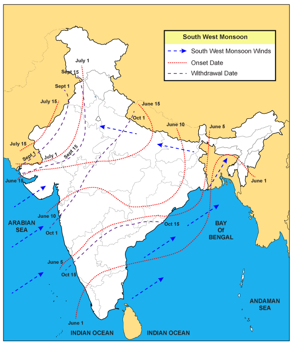
    The India Meteorological Department (IMD) had decided to revise the normal onset and withdrawal dates for the monsoon in some parts of the country from this year.

    Onset of Monsoon

    • The four-month southwest monsoon season, which brings as much as 70 per cent of the country’s annual rainfall, officially begins on June 1, with the onset over Kerala, and ends on September 30.
    • It takes about a month and half after onset on the Kerala coast to cover the entire country; and about a month, beginning from the northwestern parts of the country on Sept. 1 to withdraw completely.
    • Although the June 1 date for the onset of the monsoon on the Kerala coast is unlikely to be changed, the dates for onset in many other parts of the country are expected to be revised.
    • Mumbai, for example, expects to start getting rain from June 10 the revision is likely to push this date back by a few days.
    • Effectively, the monsoon is now expected to have later arrival and withdrawal dates in most parts of the country.

    Why was this revision needed?

    • The main reason for the revision in the normal dates is the changes in precipitation patterns that have been taking place over the last many years.
    • In the last 13 years, for example, only once has the onset over the Kerala coast happened on June 1.
    • While two or three days of earlier or later onset falls within the yearly variability in several years the onset happened five to seven days late.
    • Similarly, the commencement of withdrawal has happened in the first week of September only twice during this period, and last year, the withdrawal started as late as October 9 — and was completed in around just a week.

    Recent peculiarity with the exam

    • One of the significant changes being noticed is that rainfall is getting increasingly concentrated within a narrow band of days within the monsoon season.
    • So, there are extremely wet days followed by prolonged periods of dry days.
    • IMD data show that over several previous years, nearly 95 per cent of monsoon precipitation in 22 major cities of the country had happened over a period of just three to 27 days.
    • Delhi, for example, had received almost 95 per cent of its monsoon rainfall over just 99 hours. And half of Mumbai’s monsoon rain had fallen over just 134 hours, or five and a half days, on average.

    Regional variations

    • Patterns of regional variations in rainfall are also changing
    • Areas that have traditionally received plenty of rainfall are often remaining dry, while places that are not expected to get a lot of monsoon rain have sometimes been getting flooded.
    • Climate change could be one of the factors driving these changes, but there could be other reasons as well.

    What will be the impact of IMD’s move?

    For Farmers

    • The revisions are meant to reflect the changes in precipitation patterns in recent years.
    • New dates will likely nudge farmers in some parts of the country to make slight adjustments in the time of sowing their crops.
    • It would definitely have an impact on our agriculture practices — when to start sowing, when to harvest.
    • So, even if there is a delay in the arrival of monsoon by three to four days over a region, it would not matter much if there is a fairly good rainfall distribution thereafter.
    • The change in dates would affect water management practices as well.

    For Industries

    • The planning that goes to beat the heat — several cities execute heat action plans — just ahead of the monsoon would have to factor in the need to be prepared for longer periods of heat.
    • Rajeevan said many other activities including industrial operations, the power sector, or those using cooling systems, would also need to change their behaviour.
    • The power grid can, for example, have more realistic planning for peak periods of electricity consumption in certain months.

    Way Forward

    • The changed dates are expected to be announced in April, when the IMD makes its first forecast for the monsoon.
    • Agro-meteorologists, however, agree that more than the onset, it is the information about the spatio-temporal distribution of rainfall that will be more helpful for farmers.
    • Ultimately, the change in normal dates of the onset and withdrawal of the monsoon would help people understand when to expect rains, and to plan their activities accordingly.
  • Eruption of Taal Volcano


    In the Philippines, a volcano called Taal on the island of Luzon; 50 km from Manila has recently erupted.

    Taal Volcano

    • Taal is classified as a “complex” volcano. Taal has 47 craters and four maars (a broad shallow crater).
    • It is situated at the boundaries of two tectonic plates — the Philippines Sea Plate and the Eurasian plate — it is particularly susceptible to earthquakes and volcanism.
    • A complex volcano, also called a compound volcano, is defined as one that consists of a complex of two or more vents, or a volcano that has an associated volcanic dome, either in its crater or on its flanks.
    • Examples include Vesuvius, besides Taal.
    • The Taal volcano does not rise from the ground as a distinct, singular dome but consists of multiple stratovolcanoes (volcanoes susceptible to explosive eruptions), conical hills and craters of all shapes and sizes.

    Threats posed

    • Taal’s closeness to Manila puts lives at stake. Manila is a few tens of kilometres away with a population of over 10 million.
    • The volcano is currently at alert level 4, which means that a “hazardous eruption” could be imminent within a few hours to a few days.
    • Hazardous eruptions are characterised by intense unrest, continuing seismic swarms and low-frequency earthquakes.

    Earlier records of eruption

    • Taal has erupted more than 30 times in the last few centuries. Its last eruption was on October 3, 1977.
    • An eruption in 1965 was considered particularly catastrophic, marked by the falling of rock fragments and ashfall.
    • Before that, there was a “very violent” eruption in 1911 from the main crater. The 1911 eruption lasted for three days, while one in 1754 lasted for seven months.
    • Because it is a complex volcano with various features, the kinds of eruption too have been varied. An eruption can send lava flowing through the ground, or cause a threat through ash in the air.
  • Monsoon Updates

    How does El Nino affect Indian Monsoon? A Comprehensive Explainer

    As many reports speculated that El Nino is the main cause of the worsening Indian Monsoon and has played badly with Indian agriculture, we thought that we should take a big picture of El Nino and it’s scope in India.


    • The Monsoon is basically a result of the flow of moisture laden winds because of the variation of temperature across the Indian Ocean.
    • There are a number of climatic phenomena which affect it namely the El nino, La nina etc.
    • We will look at their origin, impact and way forward.

    Now, let’s take a overview and develop our understanding. 

    What happens in a Normal Year?

    • Peru Current = Humboldt Current = Cold Current.
    • During normal year 2 things are very strong – Cold Peru Current and Trade Winds.
    • As a result, cold water is dragged from Peru towards Australia.

    What would be the result of this exchange?

    • Warm water region around Australia is called Western Pacific Pool (WPP).
    • WPP = low pressure = warm air ascends = cloud formation = rain over North Australia
    • This air also joins walker cell and begins descending near Peru.
    • Descending air = anti-cyclonic condition = high pressure = stability = no cloud/rain = Drought in Atacama Desert.

    (Simply, Walker cell is the result of a difference in surface pressure and temperature over the western and eastern tropical Pacific Ocean)

    What happens below the water from Peru to Australia ?

    At Peru coast, cold water upwelling brings nutrient to surface + more lunch for Plankton + more fishes = Peru fishermen gets happy.

    What happens above the water from Australia towards Peru?

    Warm water + low atmospheric pressure = good rainfall over Australia & Indonesia.

    What happens in La Nina Year?

    Same things as in a “normal” year, but 2 things become even “stronger” –

    • Cold Peru Current
    • Trade Winds

    What’s the Result?

    • Too many fishes at Peru coast = oversupply of fishes = prices become dirt cheap.
    • Too much rain / flood over Australia and Indonesia.

    This is what happens in normal and La Nino year, Let’s back to El Nino!


    What happens in an El Nino year?

    Two things become weak.

    • Cold Peru Current
    • Trade Winds
    • As result, cold water is not dragged from Peru to Australia.
    • But reverse happens, warm water is dragged from Australia towards Peru.
    • Consequently, warm water + low pressure condition develops in the Eastern Pacific (Peru) and Cold condition + high pressure in Western Pacific (Australia).

    What will happen if pressure is inversely related with amount of rainfall ?

    • Rain & Floods at Peru, Atacama and even Southern USA
    • Drought at Northern Australia, Indonesia- even bushfires.
    • Storms and Hurricanes in East Pacific.
    • Coral bleaching (high temperature coral dies)

    But, what is the El Nino?

    • El Nino is an Oceanic and Atmospheric phenomenon that leads to unusual warming of water in the Peru coast, occurs every 3-5 years.
    • Consequently, warm water + low pressure condition develops in the Eastern Pacific (Peru) and Cold condition + high pressure in Western Pacific (Australia).
    • Since Pressure is inversely related with amount of rainfall, El Nino causes drought situation in Australia and South East Asia.
    • It weakens the trade winds and changes in Southern Oscillation, thereby affects the rainfall pattern across the world.

    el-nino-phenomenon


    What is Southern Oscillation?

    • Alternating of (tropical) sea level pressure between the eastern and western hemispheres.
    • We can measure Southern Oscillation by observing the pressure difference between Tahiti (French Polynesia) and Darwin (Australia).

    How does El Nino affect Indian Monsoon?

    • El Nino-Southern Oscillation (ENSO) water circulation happens between Australia and Peru.
    • But, the wind movement is part of larger atmospheric circulation hence affects the rainfall over India. But, how?
    • We have learned that During normal year, the warm water moves towards Australia, this pool of warm water is called Western Pacific Pool (WPP).

    So, from WPP air rises above and moves towards two walker cells –

    • Towards Peru coast = this affects rainfall in South America.
    • Towards Mascarene High Pressure zone near East Africa. So, this affect Indian monsoon.

    Why should India worry about?

    • Drought condition decreases the agriculture output, leads to food inflation.
    • Declined supply of cotton, oilseeds and sugarcane negatively affects the textile, edible oil and food processing industries respectively.

    What is the way forward?

    Let’s discuss first Near-term Solutions?

    • Government must expand farm insurance cover and advice financial institutions to settle crop insurance claims in the drought-hit areas without delay. Otherwise, it results in farmer suicides (e.g. Maharashtra farmers’ suicide ).
    • High quality seeds of alternative crops must be distributed among farmers in drought-affected areas.
    • Need of realistic assessment of ground level situation in order to estimate the shortfall of oilseeds and pulses and help traders with market intelligence.
    • Scrapping the APMC Act and allowing free flow of agricultural goods among the states.
    • This would help bridge the mismatch of demand and supply of goods, which is the underlying factor contributing inflation.

    What should be the Long-term Solutions?

    • Developing drought free crop varieties and distributing its subsidized seeds to the farmers. It is a part of National Action plan on climate change in Agriculture.
    • Using low water use technologies like drip and sprinkler irrigation.
    • The MSP regime in India has to provide more remuneration for less water consuming crops.
    • Strengthening community watershed management and development by protecting and conserving local water sources like ponds, lakes etc.
    • Developing early warning systems and alerting the farmers much in advance like recently launched Kisan SMS scheme.

    Do you find more solutions or any way out? then, Let us know!


    Published with inputs from Arun