💥Join UPSC 2027,2028 Mentorship (July Batch) + XFactor Notes & Microthemes PDF

Subject: Geography

  • Disputes over Grand Ethiopian Renaissance Dam (GERD)

    Why in the News?

    The completion of Ethiopia’s Grand Ethiopian Renaissance Dam (GERD) has reignited tensions over Nile water rights, with Egypt and Sudan fearing reduced water flows.

    Disputes over Grand Ethiopian Renaissance Dam (GERD)

    About Grand Ethiopian Renaissance Dam (GERD):

    • Overview: Gravity dam on the Blue Nile near Ethiopia–Sudan border.
    • Construction Timeline: Under construction since 2011, led by Ethiopian Electric Power Corporation.
    • Capacity: Set to become Africa’s largest hydropower plant with 6.45 GW output.
    • Reservoir Size: Holds 74 billion cubic metres; filling may take 5–15 years.
    • Key Features: 145 m tall dam, 16 turbines, and a supporting saddle dam.
    • Purpose: Aims to power Ethiopia (65% population lacks electricity) and export surplus to neighbouring countries.
    • Disputes Around GERD:
      • Egypt’s Concern: Fears reduced water flow; Relies 90% on Nile; demands a binding filling agreement.
      • Sudan’s Worry: Concerns over flood risks and water regulation.
      • Ethiopia’s Stand: Asserts sovereign rights; began filling without consensus.
      • Stalled Talks: Tripartite negotiations have failed; Egypt warns of possible conflict.

    Back2Basics: Nile River

    • Overview: North-flowing, longest river in Africa at ~6,650 km.
    • Drainage Basin: Covers 11 countries—Tanzania, Uganda, Rwanda, Burundi, DRC, Kenya, Ethiopia, Eritrea, South Sudan, Sudan, and Egypt.
    • Main Tributaries:
      • White Nile: Recognized as the headstream, its most remote source is the Kagera River in Burundi, flowing through Rwanda into Lake Victoria. It officially begins at Jinja, Uganda, where it exits Lake Victoria.
      • Blue Nile: Originates from Lake Tana in Ethiopia and merges with the White Nile at Khartoum, Sudan.  Supplies over 80% of total Nile flow by the time it reaches Egypt.
    • Lifeline Status: Vital for Egypt and Sudan’s drinking water, irrigation, and energy needs.


    [UPSC 2008] Ogaden region has been a source of conflict between which countries?

    Options: (a) Morocco and Algeria (b) Nigeria and Cameroon (c) Angola and Zambia (d) Ethiopia and Somalia*


  • In news: Reykjanes Peninsula

    Why in the News?

    Recently a volcano erupted in south-west Iceland, continuing a pattern of recurring geological activity on the Reykjanes Peninsula.

    In news: Reykjanes Peninsula

    About the Reykjanes Peninsula:

    • Location: Situated in southwest Iceland along the Mid-Atlantic Ridge where tectonic plates diverge.
    • Volcanic Reawakening: Dormant for centuries until 2021; now sees recurring eruptions.
    • Eruption Type: Known for fissure eruptions—lava flows from cracks, not a central crater.
    • Key Sites: Includes Grindavik (evacuated), Blue Lagoon spa, and Svartsengi power plant.
    • Volcanic Importance: Part of Iceland’s 30+ active volcanic zones.

    Key Features:

    • Eruption Style: Produces steady lava flows with minimal ash output.
    • Flight Safety: Air traffic remains unaffected due to lack of stratospheric ash.
    • Evacuation Impact: Grindavik largely abandoned after 2023 lava threat.
    • Long-Term Activity: Eruptions may persist for decades or longer.
    • Iceland Snapshot: Population ~400,000; similar in size to Kentucky.
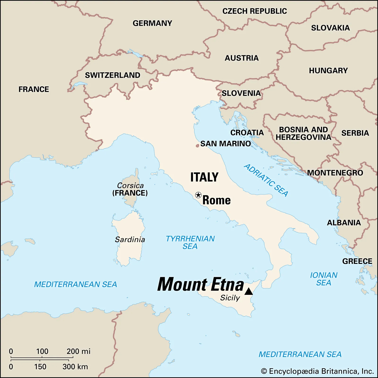
    • Tourism Appeal: Attracts visitors like other volcanic hotspots—Mexico, Indonesia, Sicily, and New Zealand.
    [UPSC 2014] Consider the following geological phenomena:

    1. Development of a fault 2. Movement along a fault

    3. Impact produced by a volcanic eruption 4. Folding of rocks

    Which of the above cause earthquakes?

    Options: (a) 1, 2 and 3 (b) 2 and 4 (c) 1, 3 and 4 (d) 1, 2, 3 and 4*


  • [17th July 2025] The Hindu Op-ed: A tectonic shift in thinking to build seismic resilience

    PYQ Relevance:

    [UPSC 2015] Earthquakes along the plate margins are still a cause of concern. India’s preparedness for mitigating their impact has significant gaps. Discuss various aspects.

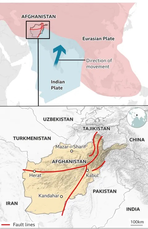
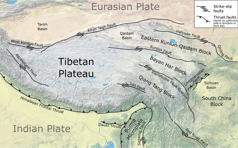
    Linkage: The article emphasizes that India’s seismic risk is rooted in the northward drift of the Indian Plate colliding with the Eurasian Plate, which shaped the Himalayas and makes the region “overdue for a ‘Great Himalayan Earthquake’.  The question specifically mentions “earthquakes along the plate margins” and critically highlights “India’s preparedness for mitigating their impact has significant gaps.


    Mentor’s Comment:  The 4.4 magnitude tremor in Delhi on July 10, 2025, though moderate, exposed the critical fragility of India’s infrastructure, especially in Delhi, where over 80% of buildings violate seismic safety norms. This event is part of a wider pattern of seismic activity across Asia, underlining the urgent need for earthquake preparedness. India, particularly northern and northeastern regions, lies in high-risk seismic zones (IV & V) due to the collision of tectonic plates, making a massive quake imminent. Urbanisation, outdated construction, and poor enforcement of seismic codes like IS 1893:2016 worsen the risk.

    Today’s editorial analyses the vulnerability to earthquakes in India. This topic is important for GS Paper I (Geography) and  GS Paper III (Disaster Management) in the UPSC mains exam.

    _

    Let’s learn!

    Why in the News?

    On July 10, 2025, a 4.4 magnitude earthquake struck near Delhi, exposing the fragile state of infrastructure.

    Why is Delhi vulnerable to earthquakes?

    • High Seismic Risk Zone: Delhi lies in Seismic Zone IV, indicating a severe seismic hazard with a peak ground acceleration (PGA) of around 0.24g. Eg: Similar Zone IV cities like Srinagar and Patna have experienced strong tremors in the past.
    • Poor Structural Compliance: Over 80% of buildings in Delhi, especially those constructed before 2000, do not comply with seismic safety codes. Eg: Unregulated high-rise apartments in East Delhi lack ductile detailing or shear walls, making them prone to collapse.
    • Liquefaction-Prone Areas: Areas like East Delhi and Yamuna floodplains are built on soft alluvial soils, which are susceptible to liquefaction during earthquakes. Eg: In the 2001 Bhuj earthquake, structures on soft soil experienced severe tilting and collapse.
    • Rapid Urbanisation Without Planning: Delhi’s urban sprawl and dense population (over 33 million) have led to haphazard construction, often violating zoning and structural norms. Eg: Many illegal colonies like those in outer Delhi lack any seismic design considerations.

    What are the vulnerable areas in India? 

    • Himalayan Region: The Himalayan belt is highly prone to earthquakes due to the collision of the Indian and Eurasian tectonic plates. Eg: Regions like Jammu & Kashmir, Himachal Pradesh, Uttarakhand, and parts of Northeast India fall under Seismic Zone V.
    • Indo-Gangetic Plain: This region experiences significant seismic activity due to the tectonic stress transfer from the Himalayan region. Eg: Parts of Bihar, Uttar Pradesh, Delhi, and West Bengal lie in Seismic Zones III and IV.
    • Peninsular India Fault Zones: Though considered geologically stable, intraplate faults in Peninsular India can still trigger strong earthquakes. Eg: Areas like Latur (Maharashtra), Koyna (Maharashtra), and Bhuj (Gujarat) have witnessed major quakes in the past.

    What are the steps taken by the Indian Government? 

    • Building Code Reforms: The government enforces Earthquake-Resistant Building Codes to ensure structural safety in seismic zones. Eg: The Bureau of Indian Standards (BIS) revised IS 1893 and IS 4326 to include updated seismic design norms across construction sectors.
    • National Seismic Zoning: India has been zoned into seismic risk areas to guide planning and construction based on earthquake vulnerability. Eg: The country is divided into Zone II to Zone V, with Zone V (like parts of Uttarakhand, Kashmir) being most earthquake-prone.
    • Disaster Management Framework: The government has established a dedicated institutional framework to coordinate disaster preparedness and response. Eg: The National Disaster Management Authority (NDMA) issues guidelines for earthquake risk mitigation and conducts regular mock drills and capacity-building programs.

    What are the steps taken at the international level?

    • Sendai Framework for Disaster Risk Reduction (2015–2030): The United Nations adopted this global framework to strengthen disaster preparedness, promote resilient infrastructure, and reduce disaster losses. Eg: Countries like Japan and Chile have aligned their national disaster policies with Sendai priorities, emphasizing risk governance and early warning.
    • Global Seismic Hazard Assessment Program (GSHAP): Led by the International Lithosphere Program, this initiative provides seismic hazard maps to help countries plan safer infrastructure. Eg: Italy and other European nations use GSHAP data to revise building codes and zoning laws in earthquake-prone zones.
    • Early Warning Systems and Technology Sharing: Countries are collaborating to develop earthquake early warning systems and share real-time seismic data across borders. Eg: The Pacific Tsunami Warning Center and Japan’s Earthquake Early Warning System help neighbouring nations prepare faster for seismic events.

    What global lessons can India adopt from other countries? (Way forward)

    • Building Code Enforcement: Strong and regularly updated building codes ensure that infrastructure can withstand seismic shocks, reducing casualties and damage. Eg: After the 1995 Kobe earthquake, Japan revised its seismic building codes, which helped limit destruction during the 2011 Tōhoku earthquake.
    • Early Warning Systems: Timely alerts enable people to take quick protective actions, such as evacuation or shutting down utilities, before the shaking begins. Eg: In 2017, Mexico City’s SASMEX system gave a 20-second alert before the quake struck, allowing residents to prepare.
    • Retrofitting Incentives: Providing financial support for retrofitting older buildings motivates citizens to strengthen structures against earthquakes. Eg: The Earthquake Brace + Bolt program in California offers funds to homeowners, promoting structural safety in vulnerable areas.
  • In news: Great Trigonometric Survey (GTS)

    Why in the News?

    This newscard highlights the role of Indian assistants in completing the Great Trigonometric Survey (GTS), which began in 1802 to map India’s geography.

    About the Great Trigonometrical Survey (GTS):

    • Launch and Objective: The GTS was a massive scientific and cartographic initiative launched in 1802 by the British to map India with unprecedented precision using trigonometry and geodesy.
    • Initiator: It was conceptualised by William Lambton, a British army officer, and carried out under the East India Company.
    • Purpose: It aimed to measure Earth’s curvature, create accurate maps, and support colonial administration, scientific research, and military planning.
    • Survey Method: It used triangulation, involving a network of interconnected triangles built from a known baseline to calculate distances and angles over large areas.
    • First Baseline: The initial baseline was measured in 1802 at St. Thomas Mount near Madras (Chennai) and extended over 2,600 km up to the Himalayas.
    • Instruments Used: The survey used massive theodolites (weighing up to half a ton) and measuring chains, requiring large teams for operation and transport.
    • Scientific Outcome: It led to the formulation of the Everest Spheroid, a geodetic reference model still used for mapping in South Asia.
    • Duration and Leadership: Although planned to take 5 years, the project lasted nearly 70 years (until 1871) and was led by successors such as George Everest (after whom Mt. Everest was named), Andrew Scott Waugh, and James Walker.

    How did the GTS led to the Mapping of India?

    • First Accurate Maps: It provided scientific maps that corrected earlier errors, enabling modern geodetic frameworks for administration and infrastructure.
    • Survey Range: It mapped from southern India to the Himalayas, supporting large-scale development and scientific measurement.
    • Great Arc Measurement: It measured the Great Arc (Chennai to Dehradun), a significant geodetic arc that helped calculate Earth’s curvature.
    • Himalayan Heights: Using triangulation data, the survey measured 79 Himalayan peaks, including Mount Everest, K2, and Kangchenjunga.
    • Mount Everest Identification: In 1852, Peak XV was identified as the world’s highest mountain, later named Mount Everest in honour of George Everest.
    • Latitude-Longitude System: It produced precise longitude and latitude coordinates, crucial for navigation, military logistics, and administration.
    • Infrastructure Impact: Survey benchmarks supported railways, roads, canals, and earthquake studies, many of which remain relevant today.

    Contribution of Indians to the GTS:

    • Syed Mir Mohsin Husain: A jeweller from Arcot who repaired critical instruments and was later appointed as an instrument maker in the Surveyor General’s office.
    • Radhanath Sikdar: An Indian mathematician who calculated the height of Mount Everest in 1852, confirming it as the tallest peak globally.
    • Indian Field Workers: Thousands of Indian flagmen, khalasis, and labourers undertook challenging tasks like carrying heavy equipment, setting markers, and working in hazardous environments.
    • Logistical Support: Indian artisans and technicians repaired, calibrated, and adapted instruments, making the project feasible under Indian conditions.
    • Role of Pundits: Trained Indian “pundits” conducted secret surveys in Tibet and politically sensitive regions, where British officers were restricted.
    [UPSC 2018] Among the following cities, which one lies on a longitude closest to that of Delhi?

    Options: (a) Bengaluru* (b) Hyderabad (c) Nagpur (d) Pune


  • [pib] Fossils reveal Kashmir Valley’s Climatic Past

    Why in the News?

    Researchers from Birbal Sahni Institute of Palaeosciences (BSIP), Lucknow, have found strong evidence that the Kashmir Valley, now cool and temperate, was once a warm, humid subtropical region.

    About the Study on Fossils:

    • Site of Fossil Discovery: The fossils were recovered from the Karewa sediments of the Kashmir Valley, known for preserving ancient plant remains.
    • Analysis: Researchers used CLAMP (Climate Leaf Analysis Multivariate Program) to analyze fossil leaf shape, size, and margins to estimate past temperature and rainfall patterns.
    • Coexistence Approach: It was also used, comparing fossil plants with their modern relatives to reconstruct the region’s ancient climate.

    Key Findings:

    • Past Climate Type: The Kashmir Valley once had a warm, humid subtropical climate, very different from the cool, Mediterranean-type climate it experiences today.
    • Vegetation Evidence: Fossilized leaves showed diverse subtropical plant types no longer found in the region’s current vegetation.
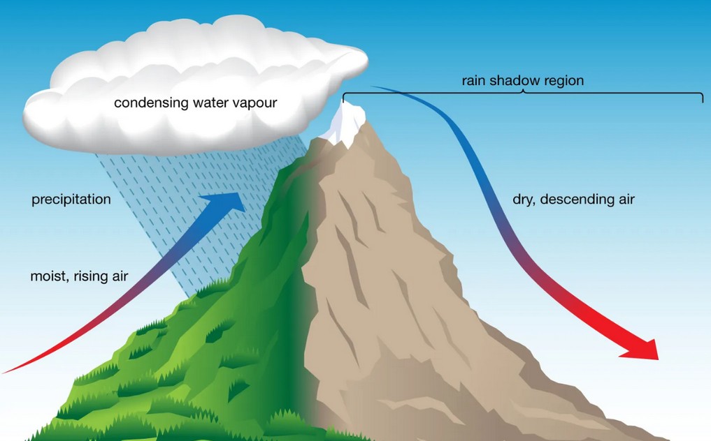
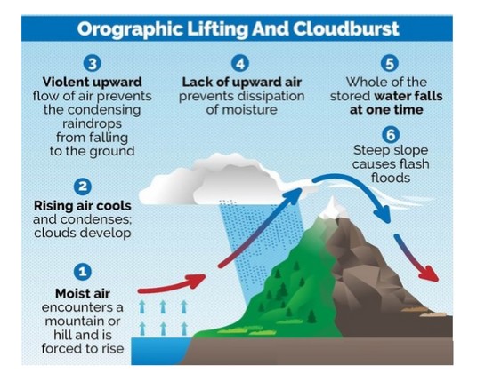
    • Role of Tectonic Uplift: The tectonic uplift of the Pir Panjal Range was identified as a key factor that blocked the Indian summer monsoon from entering the valley.
    • Climatic Transition: This led to gradual drying of the region and a shift from subtropical forests to temperate ecosystems.
    • Impact of Mountain-Building: The study shows that mountain-building (tectonic uplift) can directly affect climate patterns by altering monsoon routes.
    • Relevance to Climate Change: The findings provide insight into natural climate shifts over millions of years, helping contextualize modern climate change.
    • Ecological Vulnerability: It also highlights the fragility of mountain ecosystems like the Himalayas, which are vulnerable to both natural and human-induced environmental changes.

    Back2Basics:

    • Karewa Sediments: They are plateau-like terraces in the Kashmir Valley, made up of lacustrine (lake) and fluvio-glacial deposits; They are known to preserve ancient fossils, especially of plants.
    • Subtropical Climate: A warm and humid climate with moderate to high rainfall, supporting dense vegetation. Ex: Climate of northeastern India.
    • Mediterranean-Type Climate: Characterized by mild, wet winters and hot, dry summers; Ex: Current climate of parts of the Kashmir Valley.


    [UPSC 2025] Which of the following are the evidence of the phenomenon of continental drift?

    I. The belt of ancient rocks from Brazil coast matches with those from Western Africa. II. The gold deposits of Ghana are derived from the Brazil plateau when the two continents lay side by side. III. The Gondwana system of sediments from India is known to have its counterparts in six different landmasses of the Southern Hemisphere.

    Options: (a) I and III only (b) I and II only (c) I, II and III * (d) II and III only


  • Indonesia’s Mount Lewotobi erupts

    Why in the News?

    Mount Lewotobi Laki Laki in eastern Indonesia has erupted violently, spreading ash up to 18 kilometers into the sky.

    About Mount Lewotobi: Key Features

    • Overview: Mount Lewotobi is a twin volcano located in East Nusa Tenggara province, consisting of Lewotobi Laki Laki (“Male”) and Lewotobi Perempuan (“Female”).
    • Elevation and Activity: Lewotobi Laki Laki stands at 1,584 meters and is more frequently active. Lewotobi Perempuan is taller at 1,703 meters but less active historically.
    • Volcanic Type: Both mountains are stratovolcanoes, formed by successive layers of lava, ash, and volcanic debris.
    • Lava Domes: During the 20th century, both volcanoes developed small lava domes within their summit craters.
    • Magma Composition: The primary eruptive material from both volcanoes is andesite, a type of intermediate volcanic rock.
    • Tectonic Location: The volcanoes lie on the Pacific Ring of Fire, a seismically active belt known for frequent earthquakes and volcanic eruptions.

    Back2Basics: The Pacific Ring of Fire

    • Overview: The Pacific Ring of Fire is a 40,000-km-long horseshoe-shaped zone encircling much of the Pacific Ocean, known for intense geological activity.
    • Volcanic Density: This region contains around 75 percent of the world’s volcanoes—more than 450 in total.
    • Seismic Activity: Approximately 90 percent of the world’s earthquakes occur within this zone.
    • Geographic Spread: It extends from New Zealand through Indonesia, the Philippines, and Japan, across to the Aleutian Islands, and then down the western coasts of North and South America.
    • Tectonic Plates Involved: Several major tectonic plates intersect here, including the Pacific, Philippine, Juan de Fuca, Cocos, Nazca, and North American plates.
    • Subduction Zones: Much of the Ring features subduction zones, where one tectonic plate slides beneath another, generating magma and leading to volcanic eruptions.
    • Plate Movement: The movement of these plates is slow—typically just one to two inches per year—but it results in significant geological events over time.


    [UPSC 2018] Consider the following statements:

    1. The Barren Island volcano is an active volcano located in the Indian territory.

    2. Barren Island lies about 140 km east of Great Nicobar.

    3. The last time the Barren Island volcano erupted was in 1991 and it has remained inactive since then. Which of the statements given above is/are correct?

    Options: (a) 1 only (b) 2 and 3 (c) 3 only (d) 1 and 3


  • 1000 quakes rattle Japan’s Tokara Islands

    Why in the News?

    Japan has recorded over 1,000 tremors in two weeks near the Tokara Islands, signalling a surge in seismic activity.

    Why is Japan so prone to earthquakes?

    • Tectonic Plate Convergence: Japan lies at the junction of four major tectonic plates—the Pacific, Philippine Sea, Eurasian, and North American—which constantly collide and shift.
    • Subduction Zones: Oceanic plates (Pacific and Philippine Sea) are being pushed under continental plates, creating intense geological stress that is released as earthquakes.
    • Pacific Ring of Fire: Japan is part of this highly active seismic zone that surrounds the Pacific Ocean and accounts for about 90% of the world’s earthquakes.
    • Volcanic and Fault Line Density: The country has about 10% of the world’s active volcanoes and numerous fault lines, increasing its seismic vulnerability.

    About Tokara Islands:

    • Overview: They are a small volcanic island chain in the Ryukyu archipelago, forming part of Kagoshima Prefecture in southern Japan:
    • Geographical Location: Between Kyushu and the Amami Islands, in the East China Sea.
    • Composition: Includes 12 islands, of which 7 are inhabited, such as Nakanoshima, Takarajima, and Kodakarajima.
    • Volcanic Origin: Part of the Ryukyu Arc, a highly seismically active zone. Mount Otake, an active volcano, is located on Nakanoshima.
    • Geopolitical Relevance: The islands are gaining strategic significance due to rising tensions in the East China Sea, particularly involving China and Taiwan. Recent defense policies have called for fortification of the Tokara and Nansei Islands to enhance surveillance.
    [UPSC 2008] In the year 2007, an earthquake led to massive radioactive water leakage in the largest nuclear plant in the world. In which country did it occur?

    Options: (a) Germany (b) Canada (c) Japan* (d) USA


  • In news: Seine River

    Why in the News?

    French authorities have opened up the Seine River to public swimming for the very first time since 1923.

    In news: Seine River

    About the Seine River:

    • Overview: it is a major waterway in northern France, flowing through some of the country’s most important cultural and economic regions.
    • Length and Rank: It is approximately 777 km(483 miles) long, making it the second-longest river in France after the Loire.
    • Source and Elevation: It originates from the Langres Plateau in the Burgundy region, near the town of Source-Seine, at an elevation of about 444–471 meters above sea level.
    • Course Through France: It flows northwest, passing through regions such as Burgundy, Champagne, and Île-de-France, and cities like Troyes, Melun, Corbeil, and Paris.
    • Path Through Paris: In Paris, the Seine winds through the city center for about 13 kilometers, forming the famous islands Île de la Cité and Île Saint-Louis.
    • Tributaries: It is joined by several important tributaries, including the Marne, Yonne, Aube, and Oise rivers.
    • Drainage Basin and Rainfall: Its drainage basin spans 76,000–79,000 square kilometers, receiving moderate rainfall of 650–750 mm annually, and covering much of northern France.
    • Mouth and Termination: The river empties into the English Channel between Le Havre and Honfleur, on the Normandy coast.
    • Economic Role: The Seine supports commercial navigation and shipping, especially through the ports of Rouen and Le Havre, and provides about 50% of Paris’s drinking water.
    [UPSC 2020] Consider the following pairs: River Flows into

    1. Mekong Andaman Sea 2. Thames Irish Sea 3. Volga Caspian Sea 4. Zambezi Indian Ocean Which of the pairs given above is/are correctly matched?

    Options: (a) 1 and 2 only (b) 3 only (c) 3 and 4 only* (d) 1, 2 and 4 only


  • How India ‘added’ more than 3,500 km to its coastline

    Why in the News?

    India’s coastline has increased by about 48%, not because of new land but due to better digital mapping and updated measurements. It has grown from 7,516 km to 11,098 km, giving a clearer view of the country’s natural borders.

    What led to the increase in India’s measured coastline length?

    • Use of High-Resolution Mapping Technology: The shift from low-resolution (1:4,500,000) to high-resolution data (1:250,000) allowed finer measurement of the coastline’s bends and curves. Eg: Modern GIS software captured intricate coastal shapes that older manual methods missed.
    • Inclusion of Previously Omitted Offshore Islands: Many small offshore islands that were earlier not visible or excluded due to manual limitations are now included. Eg: Several minor islands around the Andaman & Nicobar and Lakshadweep regions added extra coastline length.
    • Coastline Paradox and Irregularity of Landforms: Coastlines are naturally irregular; measuring them at a finer scale captures more detail, thus increasing total length. Eg: Like using a one-meter ruler instead of a one-kilometre one—more small features are counted, increasing overall length.

    Why is the coastline paradox relevant to India’s coastal mapping?

    • Scale-Dependent Measurement: The coastline paradox shows that a coastline’s length varies based on the scale or resolution used for measurement—the finer the scale, the longer the coastline appears. Eg: Measuring with 1:250,000 scale data gives a much longer length than with 1:4,500,000 scale data.
    • Irregular Nature of Coastlines: Coastlines are highly irregular, full of bends, curves, and inlets, which get missed at lower resolutions but captured at higher ones. Eg: A low-resolution map smooths out land features, while high-resolution GIS tools map every minor curve.
    • No Fixed Length: The paradox proves that coastlines do not have a finite length—they can always be measured in more detail, leading to ever-changing figures. Eg: Even with current high-tech tools, the actual coastline length keeps increasing with better precision in future reassessments.

    How does reassessing the coastline and islands impact governance and security?

    • Accurate Administrative and Developmental Planning: Reassessment provides a clear understanding of territorial boundaries, aiding in efficient governance and infrastructure development. Eg: Updated coastline data helps plan coastal roads, ports, and disaster response systems in states like Gujarat and West Bengal.
    • Strengthening Maritime Security and Surveillance: Precise mapping helps in identifying vulnerable points, enabling better deployment of naval and coast guard resources. Eg: Mapping of remote islands assists in setting up radar stations and surveillance posts in regions like Lakshadweepand Andaman & Nicobar.
    • Strategic Assertion and Environmental Management: Helps in asserting sovereignty over maritime zones and managing coastal ecosystems more effectively. Eg: Reassessment supports India’s claim over its Exclusive Economic Zone (EEZ) and strengthens climate resilienceplanning in coastal areas.

    What challenges exist in accurately counting India’s offshore islands?

    • Ambiguity in Definitions and Tidal Variations: Some landforms may appear as islands during high tide but get connected to the mainland during low tide, causing confusion in classification. Eg: Certain coastal features in Sundarbans and Gulf of Khambhat shift between island and non-island status based on tide levels.
    • Discrepancies Across Agencies and Lack of Standardisation: Different agencies like state governments, Coast Guard, and Surveyor General have reported varying island countsdue to inconsistent definitions and methods. Eg: In 2016, the Surveyor General listed 1,382 islands, while other agencies reported 1,334, leading to a need for data reconciliation.

    Way forward: 

    • Standardised Methodology and Regular Reassessment: Adopt a uniform classification system for islands and coastlines across all agencies, and institutionalise periodic reassessments using high-resolution GIS and satellite data every 10 years.
    • Integrated Coastal Management and Strategic Mapping: Develop a centralised coastal database linking administrative, ecological, and security data to support policy-making, climate resilience, and maritime defence planning.

    Mains PYQ:

    [UPSC 2024] In a crucial domain like the public healthcare system, the Indian State should play a vital role to contain the adverse impact of marketisation of the system. Suggest some measures through which the State can enhance the reach of public health care at the grassroots level.

    Linkage: This article explicitly highlights alcohol consumption as a significant public health issue in India, leading to injuries, mental illness, non-communicable diseases like cancer, and contributing to approximately 2.6 million Disability-Adjusted Life Years (DALYs) in 2021.

  • Legal mandate for One Nation, One Time 

    Why in the News?

    The Government of India has mandated the use of Indian Standard Time (IST) across all legal, commercial, digital, and administrative sectors.

    About Indian Standard Time (IST):

    • It is the official time zone of India, set at Coordinated Universal Time (UTC) +5:30 and based on the 82.5° E longitude passing through Mirzapur, Uttar Pradesh.
      • Neighbouring countries such as Sri Lanka also use the same UTC+5:30 offset.
    • IST meridian passes through 5 Indian states: Uttar Pradesh, Madhya Pradesh, Chhattisgarh, Odisha, and Andhra Pradesh.
    • It was established in 1906, replacing older regional time zones like Bombay, Calcutta, and Madras Time.
    • It is maintained by the National Physical Laboratory (CSIR-NPL) using ultra-precise atomic clocks, which lose only one second in millions of years.
    • India does NOT observe daylight saving time; IST remains constant throughout the year.

    Back2Basics:

    Greenwich Mean Time (GMT):

    • GMT is the mean solar time at the Prime Meridian (0° longitude) located at the Royal Observatory in Greenwich, London.
    • It was established in 1884 during the International Meridian Conference as the world’s time standard.
    • It is based on astronomical observations, specifically the mean position of the Sun over time.
    • It does not change with the seasons and does not observe Daylight Saving Time (DST).
    • Although now largely replaced by UTC in scientific and civil contexts, GMT is still used in some regions (e.g., the UK during winter months).

    Coordinated Universal Time (UTC):

    • UTC is the primary time standard by which the world regulates clocks and time.
    • It was established in 1960 and is maintained by a network of high-precision atomic clocks worldwide.
    • UTC is adjusted periodically by leap seconds to compensate for the Earth’s irregular rotation speed.
    • It is used in aviation, computing, space science, and by international organisations like the UN and ITU.
    • Unlike GMT, which is purely solar-based, UTC combines atomic time (TAI) with occasional corrections for Earth’s rotation.

    IST in Context:

    • IST = GMT + 5:30
    • IST = UTC + 5:30


    Steps to Implement One Nation, One Time:

    [1] Time Dissemination Project:

    • It is a government initiative to ensure accurate, synchronised, and secure timekeeping across India.
    • It is led by the Department of Consumer Affairs, in collaboration with CSIR-NPL and ISRO.
    • Five Regional Reference Standard Laboratories (RRSLs) are being established in Ahmedabad, Bengaluru, Bhubaneswar, Faridabad, and Guwahati.
    • These labs use atomic clocks and protocols like Network Time Protocol (NTP) and Precision Time Protocol (PTP) to maintain accuracy within microseconds.

    [2] Legal Metrology (IST) Rules, 2025: Key Provisions

    • Mandatory Use of IST: IST, as maintained by CSIR-NPL, becomes the sole legally recognized time standard in India.
    • Prohibition of Foreign Time Sources: Use of foreign systems like GPS time will be banned unless specifically approved by the government.
    • Sync Requirements: All government bodies, financial institutions, power grids, and telecom operators must synchronize their systems with IST.
    • Audit and Compliance: The system will be monitored through periodic audits and penalties will be imposed for violations.
    • Special Exemptions: Activities such as scientific research, astronomy, and national security operations may use alternative time sources after government approval.


    [UPSC 2025] Consider the following countries:

    I. United Kingdom II. Denmark III. New Zealand IV. Australia V. Brazil How many of the above countries have more than four time zones?

    (a) All the five (b) Only four * (c) Only three (d) Only two