The Volcanic Island of Rapa Nui (also known as Easter Island) has always been mysterious due to its harsh geography and iconic Moai statues.
About Rapa Nui Island
Details
Location
• Situated in the southeastern Pacific Ocean, Rapa Nui is part of Polynesia and a territory of Chile.
• One of the most remote islands, about 3,500 km from Chile.
Size
• Covers an area of 160 sq. km.
Geographical details
• The island has a volcanic origin, featuring lava-covered terrain and rocky soil.
• Notable volcanoes include Terevaka, Poike, and Rano Kau.
• Tropical climate with average temperatures ranging between 18°C and 28°C.
• Rainfall occurs mostly in the winter months.
Moai Statues
• Famous for over 900 moai statues, some as tall as 40 ft and weighing 75 tonnes.
• These statues were built between the 13th and 16th centuries to honor revered ancestors.
• Carved from volcanic rock and transported across great distances.
Discovery
• Discovered by European sailors on Easter Sunday, 1722, which gave it the name Easter Island.
• The island had been settled centuries earlier by Polynesian explorers who navigated thousands of kilometers of ocean.
Significance of New Findings
• Recent studies, including the use of AI analysis of satellite images, have debunked earlier theories of ecological collapse.
• Genetic studies show Native American ancestry before European contact, indicating earlier interactions with South America.
PYQ:
[2018] Consider the following statements:
1. The Barren Island volcano is an active volcano located in the Indian territory.
2. Barren Island lies about 140 km east of Great Nicobar.
3. The last time the Barren Island volcano erupted was in 1991 and it has remained inactive since then.
Which of the statements given above is/are correct?
India has launched Operation Sadbhav to provide humanitarian assistance to Southeast Asian countries affected by Typhoon Yagi, including Vietnam, Laos and Myanmar.
Typhoon Yagi: Origin and Impact
Typhoon Yagi began as a tropical storm in the western Philippine Sea on September 1, 2024.
Yagi, which means goat or the constellation ofCapricornus in Japanese.
It made landfall in the Philippines but intensified again due to warm waters in the South China Sea, reaching Category 3 winds by September 4.
Yagi further strengthened to a Category 5 typhoon with peak winds of 260 kmph, making it one of only four Category 5 storms recorded in the South China Sea.
Although downgraded to a tropical depression, it continued to bring heavy rains and floods to Myanmar and other areas.
What areTyphoons?
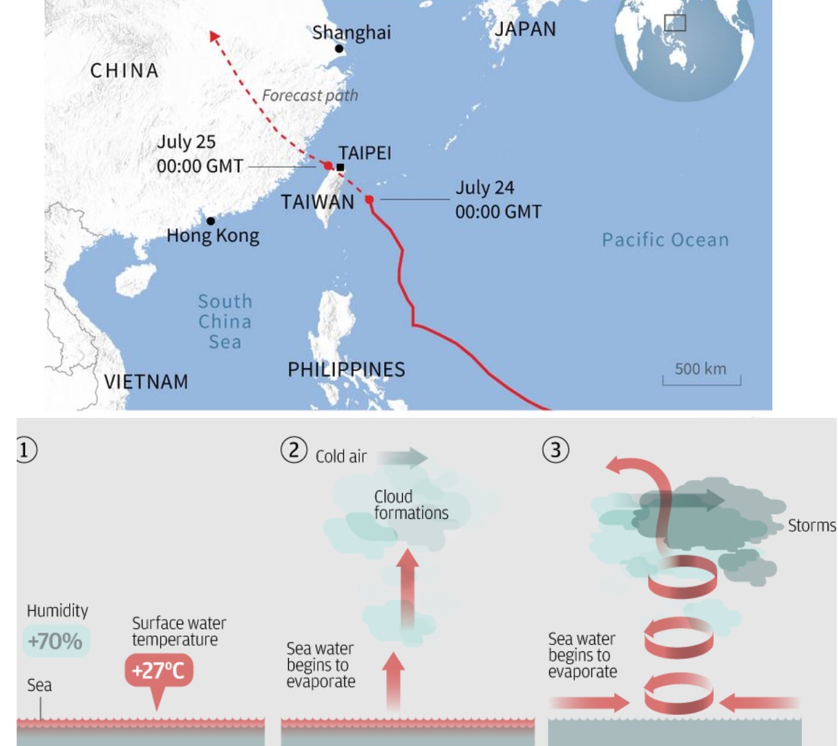
A Typhoon is a type of tropical cyclone that forms in the northwestern part of the Pacific Ocean, particularly affecting East Asia, Southeast Asia, and parts of Oceania.
They are characterized by strong winds, heavy rain, and can cause severe flooding, storm surges, and damage to infrastructure.
Key Features of Typhoons:
Formation Region: Typhoons form in the Northwestern Pacific Ocean, primarily between 100°E and 180°E.
Wind Speed: To be classified as a typhoon, sustained winds must exceed 119 km/h.
Structure: Like hurricanes, typhoons have a central eye (calm area) surrounded by a violent eyewall where the strongest winds and heaviest rains occur.
Season: Typhoons typically occur from May to October, with a peak from August to September.
Global Terminology:
Typhoon: Northwest Pacific Ocean.
Hurricane: North Atlantic, Central and Eastern North Pacific Oceans.
Cyclone: South Pacific and Indian Ocean.
PYQ:
[2020] Consider the following statements:
1. Jet streams occur in the Northern Hemisphere only.
2. Only some cyclones develop an eye.
3. The temperature inside the eye of a cyclone is nearly 10ºC lesser than that of the surroundings.
Which of the statements given above is/are correct?
A rare August cyclone, named ‘Asna’, currently positioned off the Kutch coast is even more remarkable for having originated over land.
Why was there a lot of excitement over Asna?
“Asna” is notable because it’s the first cyclone in August in the North Indian Ocean since 1981. August is typically not part of the cyclone season in this region.
The cyclone began as a land-born depression that intensified as it moved over the warm waters of the Arabian Sea. It formed from a rare strong low-pressure system that grew unusually powerful over land.
Asna’s formation is linked to the broader context of rapid warming over the Arabian Sea, influenced by climate change. The northward shift of the low-level jet stream due to warming over West Asia contributed to its development.
Why does the North Indian Ocean have two cyclone seasons?
The North Indian Ocean has two distinct cyclone seasons due to the unique monsoonal circulation patterns in the region:
Pre-monsoon season (March-May): The Arabian Sea warms rapidly during this time as the sun crosses over to the Northern Hemisphere. The Bay of Bengal is relatively warmer and begins producing atmospheric convection and rainfall. This leads to cyclogenesis in both the Arabian Sea and the Bay of Bengal.
Post-monsoon season (October-December): This is the northeast monsoon season for India. The Arabian Sea cools due to the strong southwesterly winds and mixing of cold subsurface waters. However, the Bay of Bengal remains favourable for cyclogenesis. The post-monsoon season is the major cyclone season in the North Indian Ocean
How is climate change affecting the region?
Warming of the Indian Ocean: Climate change is amplifying the warming of the Indian Ocean, with more heat being transferred from the Pacific Ocean and Southern Ocean. This increases the overall sea surface temperature (SST), crucial for cyclone formation.
Monsoon and cyclones: The warming affects the monsoon patterns and has the potential to change cyclone intensity. More heat and moisture from the warming seas lead to more energy available for cyclones.
Impact on global ocean circulation: The warming of the Indian Ocean is also affecting global ocean currents, impacting heat uptake by the Pacific Ocean and water sinking in the North Atlantic. The Indian Ocean is playing a central role in global climate change processes.
Way forward:
Strengthening Early Warning Systems: Enhance real-time monitoring and forecasting of cyclones, particularly in the pre- and post-monsoon seasons, using satellite data and advanced models.
Building Climate Resilience: Implement climate adaptation strategies, especially for coastal communities, by improving infrastructure and disaster preparedness to cope with increasing cyclone intensity due to climate change.
Mains PYQ:
Q Discuss the meaning of colour-coded weather warnings for cyclone prone areas given by India Meteorological Department. (UPSC IAS/2022)
Researchers have been curious about why the majority of gold nuggets discovered throughout history have been found in orogenic quartz veins.
Location and distribution of Gold:
Orogenic gold systems are commonly found in mountainous regions where large-scale geological processes, such as the collision of tectonic plates, have occurred.
For example, the Himalayas, the Canadian Shield, and the Western Australian goldfields.
Large gold nuggets are often found in orogenic quartz veins formed during the tectonic processes that create mountains.
These nuggets form because, during earthquakes, the stress on quartz crystals causes a reaction that deposits gold on their surfaces. This process happens repeatedly, leading to the accumulation of gold nuggets.
Note:
Gold nuggets are naturally occurring pieces of gold that have formed into lumps or chunks. They are typically found in riverbeds, streams, or within rock formations, often in quartz veins.
Orogenic quartz veins are quartz veins that form in mountainous regions.
Findings by Researchers:
Piezocatalytic Effect and Gold Accumulation: Researchers discovered that the piezocatalytic effect of quartz under seismic stress causes the accumulation of gold in quartz veins.
The piezoelectric quartz crystal generates an electric field when subjected to stress.
This field can drive electrochemical reactions at the interface between the quartz and a surrounding aqueous solution containing dissolved gold. These reactions cause gold to be deposited on the quartz surface.
Seismic Activity and Localized Gold Deposits: The study suggests that gold nuggets in orogenic systems are formed through repeated piezocatalytic reactions over time, driven by natural seismic activity. This process explains the highly localized and interconnected nature of gold deposits within quartz veins.
Conclusion: Researchers have found that gold nuggets in orogenic quartz veins form through piezocatalytic reactions caused by seismic stress on quartz. This process drives gold deposition on quartz surfaces, explaining the concentration and localization of gold in mountainous regions.
Mains PYQ:
Q Craze for gold in Indian has led to surge in import of gold in recent years and put pressure on balance of payments and external value of rupee. In view of this, examine the merits of Gold Monetization scheme. (UPSC IAS/2015)
Q Discuss the recent measures initiated in disaster management by the Government of India departing from the earlier reactive approach. (UPSC IAS/2020)
Q Describe various measures taken in India for Disaster Risk Reduction (DRR) before and after signing ‘Sendai Framework for DRR (2015-2030)’. How is this framework different from ‘Hyogo Framework for Action, 2005’? (UPSC IAS/2018)
Q How important are vulnerability and risk assessment for pre-disaster management? As an administrator, what are key areas that you would focus on in a Disaster Management System? (UPSC IAS/2013)
Q Disaster preparedness is the first step in any disaster management process. Explain how hazard zonation mapping will help disaster mitigation in the case of landslides. (UPSC IAS/2019)
Mentor comment: On August 1, 2024, the Indian government introduced the Disaster Management (Amendment) Bill in the Lok Sabha, aiming to amend the Disaster Management Act of 2005. The Bill centralized disaster management further by granting statutory status to existing bodies like the National Crisis Management Committee and establishing an Urban Disaster Management Authority for major cities. While it seeks to empower the National and State Disaster Management Authorities to prepare disaster plans and create a national disaster database, critics argue it complicates the disaster response framework and could delay actions during emergencies, undermining the Act’s original intent.
_
Let’s learn!
Why in the News?
The Disaster Management (Amendment) Bill 2024 introduced recently complicates the disaster response framework and could delay actions during emergencies, undermining the Act’s original intent
What are the key highlights/features of this Bill?
Statutory Recognition for Existing Bodies: Grants statutory status to pre-existing organizations such as the National Crisis Management Committee (NCMC) and the High-Level Committee (HLC), enhancing their roles in managing major disasters.
Regulatory Powers: Empowers the NDMA to make regulations under the Act with prior approval from the central government, allowing for greater flexibility in disaster management.
Disaster Database: Mandates the creation of a disaster database at both national and state levels, which will include information on disaster assessments, fund allocations, expenditures, preparedness and mitigation plans, and risk registers.
Empowerment of National and State Authorities: The Bill empowers the National Disaster Management Authority (NDMA) and State Disaster Management Authorities (SDMAs) to directly prepare disaster management plans, replacing the previous role of the National and State Executive Committees.
It also establishes UDMAs (Urban Disaster Management Authorities) for state capitals and large cities with municipal corporations, excluding Delhi and Chandigarh.
State Disaster Response Force (SDRF): Provides for the constitution of SDRFs by state governments, which will be responsible for disaster response at the state level. The Bill allows states to define the functions and terms of service for these forces.
Focus on Disaster Risk Reduction (DRR): Expands the definition of disaster management to include disaster risk reduction, emphasizing proactive measures to reduce vulnerability and enhance preparedness.
Penalties for Non-compliance: Introduces provisions allowing the central and state governments to direct individuals to take necessary actions or refrain from actions to mitigate disaster impacts, with penalties for non-compliance capped at ₹10,000.
Critics around the Disaster Management (Amendment) Bill, 2024:
Centralization of Decision-Making: The Bill dilutes the NDRF’s purpose by removing specific uses for the fund, which has historically led to delays in aid distribution during severe disasters, as seen in the delayed response to Tamil Nadu’s needs compared to Karnataka’s.
This centralization may hinder prompt action in urgent situations.
Restricted Definition of ‘Disaster’: The Bill does not classify ‘heatwaves’ as a notified disaster, despite their increasing frequency and severity in India. This restrictive approach limits the scope for addressing emerging climate-induced challenges effectively.
Conclusion:
There is a need to re-visit the Centre’s efforts in addressing the issue of financial preparedness when it comes to the management of and response to disasters. The decision should avoid the single most event of the Wayanad Disaster and needs to have a broader view. After all, a blame game will only move away from realizing the true spirit of cooperative federalism.
Gujarat and parts of Rajasthan are facing severe flooding caused by a land-based deep depression.
The unusual formation of this deep depression over land was intensified by moisture influx from soils or the Bay of Bengal and the Arabian Sea.
What is Land-Based Deep Depression?
A land-based deep depression is a type of cyclonic system characterized by a significant drop in atmospheric pressure leading to sustained wind and significant weather impact.
They form and intensify over land, which is relatively rare due to the limited availability of moisture.
Characteristics:
It forms over land or water.
Wind Speed ranges from 51 to 62 km/h, just below the threshold for a tropical cyclone (62-88 km/h).
Relies on moisture from soilandsurrounding environments rather than oceanic sources.
It often has an unpredictable path and can cause significant rainfall and localized flooding.
Implications of Land-Based Deep Depressions
These systems can bring prolonged and intense rainfall, leading to widespread flooding, especially in regions unaccustomed to high levels of precipitation.
Heavy rainfall can lead to significant soil erosion, affecting agricultural productivity and altering landscapes.
Prolonged flooding can cause waterlogging in agricultural fields, leading to soil salinization and reduced fertility.
PYQ:
[2012] Consider the following statements:
1. The duration of the monsoon decreases from southern India to northern India.
2. The amount of annual rainfall in the northern plains of India decreases from east to west.
Which of the statements given above is/are correct?
India and Russia signed the working plan of the Joint Russian-Indian Commission on Cooperation in the Field of Emergency Management for 2025-2026.
Background of the Cooperation:
The meeting held in Moscow aimed to strategize the execution of previous agreements between India and Russia, including:
The Inter-Governmental Agreement (IGA) for cooperation in the field of Emergency Management was signed in December 2010.
The regulation was established in 2013 to create the Indo-Russian Joint Commission for Cooperation in the prevention and elimination of emergency situations.
The first meeting of this commission was held in New Delhi in 2016.
About the Joint Commission on the Cooperation in the Field of Emergency Management for 2025-2026
It is an initiative aimed at enhancing collaboration between India and Russia in the area of disaster management and emergency response.
The plan covers a two-year period from 2025 to 2026 and focuses on several key areas:
Use of Space Monitoring Technologies: To improve risk forecasting and emergency response capabilities.
Exchange of Experiences: On responding to large-scale disasters to enhance preparedness and response strategies.
Training of Specialists: In fire and rescue operations to build a robust capacity for emergency management.
The next meeting is scheduled to be held in India in 2026 to facilitate cooperation and strategic planning in emergency management.
About the Indo-Russian Joint Commission for Cooperation
Established in 2013, it seeks to formalize and enhance cooperation between India and Russia in the prevention and elimination of emergency situations.
It was formed under the framework of the Inter-Governmental Agreement (IGA) for Cooperation in the Field of Emergency Management, signed in December 2010.
The commission serves as a platform for India and Russia to collaborate on various aspects of disaster management, including:
Prevention and Preparedness: Developing strategies and sharing expertise to prevent and prepare for potential disasters.
Response and Recovery: Coordinating efforts to respond to emergencies and support recovery efforts following disasters.
Capacity Building: Enhancing the skills and knowledge of personnel involved in emergency management through joint training programs and knowledge exchange.
It facilitates a structured approach to managing disasters by leveraging the strengths and resources of both countries.
A recent study on frequent mass wasting in Sedongpu Gully and rapid warming raises concerns for India’s Northeast region.
About Sedongpu Gully:
The Sedongpu gully (29°47′7.20′′N, 94°55′24′′E) is in the large bend region of the Yarlung Tsangpo River, located in the southeastern Tibetan Plateau.
Debris flows have occurred in two adjacent gullies, namely Sedongpu Gully (SDP) and Zelongnong Gully (ZLN), since the 1950s.
Mass Wasting in the Gully: Stats and Reasons
Since 2017, over 700 million cubic meters of debris have been mobilized in the Sedongpu Gully catchment, with more than 68% of the total 19 identified mass-wasting events occurring in this period.
The events include ice-rock avalanches (IRAs), ice-moraine avalanches (IMAs), and glacier debris flows (GDFs).
Causes: The increased frequency of mass wasting is attributed to a combination of long-term warming and seismic activity.
The area rarely experienced temperatures above 0º C before 2012, but climate change has led to significant warming, destabilizing permafrost and increasing landslide activity.
The 6.4-magnitude Nyingchi earthquake in November 2017 also contributed to the destabilization of slopes.
Implications of sedimentation from mass wasting events:
River Choking and Flash Floods: The study warns that the increased sedimentation from mass wasting events could choke river channels, particularly affecting the Brahmaputra River system.
Hydropower Projects: China is planning to construct a massive 60-gigawatt hydropower project on the Tsangpo River, which could exacerbate sedimentation issues downstream.
This project is expected to have three times the capacity of the Three Gorges Dam, raising concerns about river management and flood risks in India and Bangladesh.
Historical Flood Events: Past incidents, like the 2000 floods in Arunachal Pradesh caused by landslides blocking the Tsangpo River, show how dangerous landslides can be for areas downstream.
The chance of similar disasters is higher now because of the ongoing geological instability in the Sedongpu Gully.
Way forward:
Bilateral and Multilateral Dialogues: India should intensify diplomatic efforts with China, advocating for shared water management strategies and transparency in hydropower projects on the Tsangpo River.
Real-Time Monitoring: Establish advanced real-time monitoring systems for the Brahmaputra River and its tributaries, using satellite imagery, remote sensing, and ground-based observations to track landslides, sedimentation, and water flow.
Mains question for practice:
Q Discuss the potential risks posed by the increasing frequency of mass wasting events in the Sedongpu Gully and the implications for India’s Northeast region. (150 words) 10M