💥Join UPSC 2027,2028 Mentorship (July Batch) + XFactor Notes & Microthemes PDF

Subject: Geography

  • Barak River

    Why in the News?

    Police found dead bodies floating in the Barak River (inflicted due to Manipur Violence).

    About the Barak River:

    Details
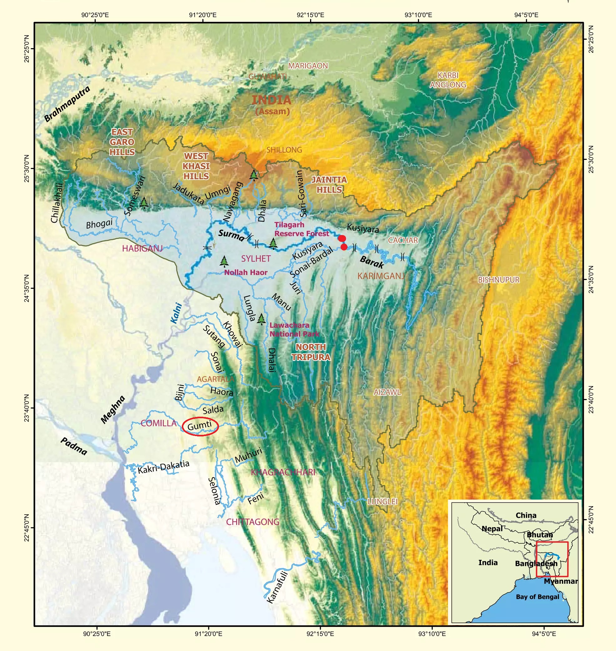
    Geographical Location • Originates from Japvo mountain in Manipur hills at 3,015 m altitude.
    • Flows south, forming the border between Assam and Manipur up to Jirimat.
    • Flows for 524 km in India, and then enters Bangladesh as Surma and Kushiyara, later becoming Meghna River.• The river is navigable in parts, with National Waterway 6 (121 km).
    Physical Features • Length: 564 km in total, with 524 km in India.
    • Drainage area in India: 41,157 sq. km (1.38% of India’s total area).
    • Tributaries: Jiri, Dhaleswari, Singla, Longai, Sonai, and Katakhal.
    Flora and Fauna/Important Sites • Fauna: Home to over 2,000 species of fish and rare creatures like the Siamese crocodile, susu dolphin, smooth-coated otter, and black mugger crocodile.
    • Flora: Includes Varzea forest, Los llamjao, tidal forests (mangroves), Pats (flat-topped table mountains), and large tropical swamps.
    • Wetlands support farming and biodiversity.
    • Hydropower projects: Tipaimukh Dam, Tista Champamati, Dhansiri Barrages.
    • Affected by flooding and soil erosion, especially during monsoon.


    PYQ:

    [2014] Consider the following rivers:

    1. Barak

    2. Lohit

    3. Subansiri

    Which of the above flows/flow through Arunachal Pradesh?

    (a) 1 only

    (b) 2 and 3 only

    (c) 1 and 3 only

    (d) 1, 2 and 3

  • What is DANA?

    Why in the News?

    The extreme conditions in eastern Spain which saw Valencia get a year’s worth of rain in just 8 hours can be blamed on an event locally known as Depresion Aislada en Niveles Altos (DANA).

    What is DANA?

    • Depresion Aislada en Niveles Altos (DANA), is commonly referred to as the “cold drop” in English.
    • It is a meteorological phenomenon in the western Mediterranean region that brings intense rainfall and flooding.
    • The term “DANA” was coined by Spanish meteorologists to specifically describe this weather phenomenon.

    Features and Location:

    • DANA occurs when cold air from the Polar Regions separates from the polar jet stream and descends over the warmer Mediterranean Sea.
    • The contrast between cold air aloft and warm, moist air near the surface causes atmospheric instability, leading to the rapid formation of cumulonimbus clouds and intense thunderstorms.
    • It primarily affects Spain and Portugal but can also impact Italy, France, and other areas around the Mediterranean Sea.
    • This occurs in autumn and spring, as temperature variations are more pronounced during these seasons.

    PYQ:

    [2014] The seasonal reversal of winds is the typical characteristic of:

    (a) Equatorial climate

    (b) Mediterranean climate

    (c) Monsoon climate

    (d) All of the above climates

  • TN declares Heatwaves a State-specific Disaster

    Why in the News?

    • The Tamil Nadu government has officially declared heatwaves a State-specific disaster.
      • It announced an ex-gratia payment of ₹4 lakh for families of individuals who die from heat-related causes, including those involved in relief operations.

    Key Details of the Declaration

    • Purpose: This declaration allows the government to provide immediate relief to those affected by extreme heat, especially during the severe temperatures of April and May 2024.
    • Funding: Relief efforts will be supported by the State Disaster Response Fund.
    • Other State-specific disasters in TN: Sea erosion, lightning, thunder, whirlwinds, and gale winds as State-specific disasters to ensure relief assistance for those impacted by these events.

    Note: 

    • Kerala in March this year, declared man-animal conflict as a state-specific disaster, becoming the first state in the country to do so.
    • Once an issue is declared a state-specific disaster, the onus to deal with it shifts to the state disaster management authority, which, powered by the Disaster Management Act, can take quicker and more decisive action.
    • Also, district collectors can directly intervene in their capacity as the chairman of the district disaster body.


    heatwave

    About Heatwaves:

    Details
    Definition A heatwave is a prolonged period of excessively hot weather, relative to the usual climate of a region.
    Occurrence Typically occurs in India between March and June.
    Declaration by IMD
    • Plains: The maximum temperature is at least 45°C
    • Hills: The maximum temperature is at least 30°C
    • Coastal regions: The maximum temperature is at least 37°C and the departure from normal is at least 4.5°C
    Formation • High-Pressure Systems: Develop when high pressure settles over a region for days or weeks.
    • Air Sinking: Forces air to sink, warming and drying it.
    • Increased Radiation: Fewer clouds lead to higher surface temperatures.
    • Surface Winds: Warm air from lower latitudes or continental winds intensify heat.
    Criteria for Declaring a Heatwave At least two stations in a meteorological subdivision must meet one of the following criteria for two consecutive days (declared on the second day):
    Based on Departure from Normal:
    – Heat Wave: Temperature departure of 4.5°C to 6.4°C above normal.
    – Severe Heat Wave: Temperature departure of >6.4°C above normal.
    Based on Actual Maximum Temperature (plains only):
    – Heat Wave: Maximum temperature reaches 45°C or higher.
    – Severe Heat Wave: Maximum temperature reaches 47°C or higher.
    Duration Typically lasts a minimum of four days but can extend to seven or ten days.
    Longest Recorded Spell: May 2015, lasting from 18 to 31 May.
    Impact of Heatwaves • Heat Strokes: Increased risk, especially for the elderly and those with chronic illnesses.
    • Increased Healthcare Costs: Higher hospital visits and death rates from related illnesses.
    • Reduced Productivity: Extreme heat affects the output of over 1 billion workers.
    • Risk of Wildfires: Heat domes can lead to wildfires.
    • Effect on Vegetation: Prolonged heat damages crops and leads to droughts.
    • Increased Energy Demands: Higher electricity usage for cooling, driving up rates.


    PYQ:

    [2013] Bring out the causes for the formation of heat islands in the urban habitat of the world.

    [2013] The annual range of temperature in the interior of the continents is high as compared to coastal areas. What is / are the reason / reasons?

    1. Thermal difference between land and water

    2. Variation in altitude between continents and oceans

    3. Presence of strong winds in the interior

    4. Heavy rains in the interior as compared to coasts

    Select the correct answer using the codes given below.

    (a) 1 only

    (b) 1 and 2 only

    (c) 2 and 3 only

    (d) 1, 2, 3 and 4

  • Cyclone Dana

    Why in the News?

    West Bengal and Odisha experienced heavy rainfall as Tropical Cyclone Dana is anticipated to make landfall later tonight.

    What are Cyclones?

    • Cyclones are wind systems rotating inwardly towards an area of low atmospheric pressure. They are categorised into Tropical (Temperature-induced) and Temperate (extra-tropical) cyclones (airmass-induced).
    • Formation Conditions: Tropical cyclones originate in warm regions, requiring conditions such as
    1. Warm sea surface (> 27°C),
    2. Coriolis Force,
    3. Pre-existing low-pressure systems,
    4. Small vertical wind speed differences, and
    5. Upper air divergence.

    Characteristics of Tropical Cyclones:

    • They form over warm water bodies due to energy derived from the condensation of warm water within cumulonimbus clouds.
    • Wind rotation is influenced by the Coriolis force, resulting in anti-clockwise rotation in the northern hemisphere and clockwise in the southern hemisphere.
    • By 30° latitude, the diminished warmth halts cyclone activity.

    What is the “Landfall” of a Cyclone?

    • Landfall occurs when a tropical cyclone moves from the sea onto the land.
    • As per the IMD, a cyclone makes landfall when the centre of the storm, or its eye, crosses the coast.
    • Landfall should not be confused with a “direct hit”, where the eyewall (area of high winds) hits land but the eye of the cyclone remains offshore.
    • According to the National Oceanic and Atmospheric Administration (NOAA), a cyclone’s strongest winds may still impact land even if the centre of the storm does not reach the coast.

    How long does a Cyclone Landfall last?

    • The duration of landfall typically lasts a few hours, depending on the wind speed and size of the storm.
    • For cyclone Dana, the landfall process is expected to last five to six hours with wind speeds around 125 km/h, impacting a wide region.
    • Cyclones usually weaken after landfall as they lose their moisture supply and experience increased surface friction.
    • While landfall is often the most destructive phase of a cyclone, it also signals the beginning of the cyclone’s dissipation.

    PYQ:

    [2015] In the South Atlantic and South Eastern Pacific regions in tropical latitudes, cyclone does not originate. What is the main reason behind this?

    (a) Sea Surface temperature are low

    (b) Inter Tropical Convergence Zone seldom occurs

    (c) Coriolis force is too weak

    (d) Absence of land in those regions

  • Baku and South Caucasus Region

    South Caucasus Region (Transcaucasia)

    Why in the News?

    • The 29th COP to the United Nations Framework Convention on Climate Change (UNFCCC) will begin on November 11, 2024, in Baku, the capital of Azerbaijan.
      • As global leaders gather near the Caspian Sea, the surrounding region of the South Caucasus faces significant climate challenges.

    Key Areas at Risk:

    (1) Regional/transboundary areas:

    • Northern Armenia and southern Georgia
    • North-west Azerbaijan and north-east Georgia (Alazani/Ganykh river basin)

    (2) Within countries:

    • Yerevan and Ararat Valley (Armenia)
    • Lake Sevan (Armenia)
    • Kura-Ara(k)s lowlands (Azerbaijan)
    • Baku and Absheron peninsula (Azerbaijan)
    • Adjara and the Black Sea coast (Georgia)
    • Tbilisi, Mtskheta-Mtianeti, and Kakheti regions (Georgia)


    About South Caucasus Region (Transcaucasia):

    Details
    Location South of the Greater Caucasus Mountains, bordered by Russia (north), Turkey and Iran (south), between the Black Sea (west) and Caspian Sea (east).
    Countries Armenia, Azerbaijan, and Georgia; includes disputed territories like Nagorno-Karabakh (Artsakh), Abkhazia, and South Ossetia.
    Mountains Lesser Caucasus Mountains (up to 3,000m); includes the Zangezur Range, Meskheti Range, and Armenian Highlands.
    Seas Between the Black Sea and Caspian Sea; Absheron Peninsula (Azerbaijan) extends into Caspian Sea, rich in oil.
    Rivers and Lakes Major rivers: Kura River (Georgia & Azerbaijan) and Aras River (Armenia & Azerbaijan). Key lake: Lake Sevan (Armenia).
    Climate
    • Continental climate: hot summers and cold winters;
    • Subtropical climate along Georgia’s Black Sea coast;
    • Semi-arid to desert climate near Caspian Sea, especially Azerbaijan.
    Natural Resources Rich in oil and natural gas, particularly in Azerbaijan; critical hub for energy pipelines like the Baku-Tbilisi-Ceyhan pipeline.
    Geopolitical Importance Strategic transit route for energy resources to Europe; region of geopolitical tensions due to conflicts (Nagorno-Karabakh, South Ossetia, Abkhazia).


    PYQ:

    [2014] Turkey is located between:

    (a) Black Sea and Caspian Sea

    (b) Black Sea and Mediterranean Sea

    (c) Gulf of Suez and Mediterranean Sea

    (d) Gulf of Aqaba and Dead Sea

  • Hurricane Milton

    Why in the News?

    Hurricane Milton made landfall near Siesta Key, Florida, USA which caused heavy rain, flooding and strong winds resulting in significant damage and loss of lives.

    Hurricane Milton: Origin and Causes

    • Hurricane Milton was a powerful storm that made landfall in Florida near Siesta Key, causing widespread damage.
    • It was a Category 5 hurricane with wind speeds of 285 km/h, making it one of the strongest hurricanes ever recorded in the Atlantic Ocean.
    • It originated in the Gulf of Mexico, an area connected to the Atlantic Ocean.

    Why it was an unusual storm?

    • Milton went from a Category 1 storm to a Category 5 storm in just 12 hours.
      • Usually, hurricanes intensify at a slower pace, but Milton’s wind speeds increased by 145 km/h in one day, which is very rare.
    • Sea-surface temperatures of 31°C were much higher than the 26°C needed for hurricane formation.
      • This excess heat allowed Milton to intensify quickly.
    • Most hurricanes follow a westward path, but Milton moved eastward and made landfall on the western coast of Florida.
      • According to scientists, very few hurricanes have taken this path before.
    • Wind shear is a change in wind speed and direction that can weaken hurricanes.
      • In Milton’s case, there was almost no wind shear, allowing the storm to grow stronger without interference.

    PYQ:

    [2020] Consider the following statements:

    1. Jet streams occur in the Northern Hemisphere only.

    2. Only some cyclones develop an eye.

    3. The temperature inside the eye of a cyclone is nearly 10ÂşC lesser than that of the surroundings.

    Which of the statements given above is/are correct?

    (a) 1 only

    (b) 2 and 3 only

    (c) 2 only

    (d) 1 and 3 only

  • [5th October 2024] The Hindu Op-ed: Kerala urgently needs to identify risk zones

    PYQ Relevance:

    Q). Discuss about the vulnerability of India to earthquake-related hazards. Give examples including the salient features of major disasters caused by earthquakes in different parts of India during the last three decades. (UPSC CSE 2021)
    Q). Describe the various causes and the effects of landslides. Mention the important components of the National Landslide Risk Management Strategy. (UPSC CSE 2021)
    Q). Discuss the recent measures initiated in disaster management by the Government of India departing from the earlier reactive approach. (UPSC CSE 2020)
    Q). Disaster preparedness is the first step in any disaster management process. Explain how hazard zonation mapping will help disaster mitigation in the case of landslides. (UPSC CSE 2019)

    Prelims:

    The 2004 Tsunami made people realize that mangroves can serve as a reliable safety hedge against coastal calamities. How do mangroves function as a safety hedge? (UPSC CSE 2011)
    a) The mangrove swamps separate the human settlements from the sea by a wide zone in which people neither live nor venture out
    b) The mangroves provide both food and medicines which people are in need of after any natural disaster
    c) The mangrove trees are tall with dense canopies and serve as an excellent shelter during a cyclone or tsunami
    d) The mangrove trees do not get uprooted by storms and tides because of their extensive roots.

    Mentor’s Comment:  Today’s editorial discusses the limitations in our present governance and management concerning Natural Disasters. The recent landslide event in Kerala is considered one of the deadliest landslides in India’s history, raising urgent concerns about the effectiveness of disaster management strategies in the region, which has a history of similar incidents over the past four decades. Previously, we saw the limitations based on the Disaster Management Act. Now, this article will help you to build a better consensus around the same theme.

    _

    Let’s learn!

    Why in the News?

    On July 30, 2024, the Wayanad district in Kerala experienced devastating landslides that resulted in significant loss of life and property.

    • The Chief Minister (Kerala) emphasized the need for a reevaluation of disaster preparedness and response approaches, highlighting the helplessness against natural calamities across the state.

    Kerala is no longer relatively disaster-free:

    • The state of Kerala which is bordered by the Arabian Sea and Western Ghats, was once viewed as disaster-free, which influenced its development patterns.
    • The frequency and intensity of disasters have surged in recent decades. Over 250 km of Kerala’s coastline is affected by erosion.
      • Further, the high population density in the Western Ghats exceeded its vulnerability to disasters.
      • Lowlands like Vembanad Lake, frequently experience flooding during monsoons.
    • The 2018 floods were labeled the “floods of the century” by the World Meteorological Organization.
    • Infrastructure development has often ignored natural drainage and slope stability, leading to increased disaster risks.

    Why a Comprehensive inventory mapping is needed?

    • Physical Geography of the Region: Tectonic activity generally correlates with landslide occurrences.
      • For example, the Wayanad region is characterized by deep gorges and ravines, which is prone to landslides.
    • Climate Change Impact: Rapid warming of the Arabian Sea increases risks of extreme weather events like floods and cyclones. For example, the Cyclone Ockhi in 2017.
    • Research Gaps: Current understanding of landslide causative factors is limited; a nuanced approach is necessary for effective disaster mitigation.
    • Monitoring Mechanisms: Establishing monitoring systems for rainfall and tremors can provide timely warnings to prevent loss of life.
    • Shrinking Safe Space: The “safe operating space” for communities in Kerala is diminishing due to increasing natural disasters.

    Need for a Paradigm Shift (Way Forward):

    • Need to work on Disaster Risk Zones: Develop disaster risk zones based on physical and social criteria within a social-ecological framework, aligned with watershed boundaries.
      • Strengthening the disaster risk governance and invest them in risk reduction to enhance resilience and preparedness would be helpful.
    • Comprehensive Approach: Emphasize all aspects of the disaster cycle: preparedness, resilience, risk reduction, mitigation, reconstruction, recovery, response, and relief.
      • The Sendai’s global framework highlights the State’s primary role in disaster risk reduction while advocating for shared responsibility with local governments, private sectors, and communities.
    • Quadruple Helix Model: Utilize a collaborative model involving community organizations, academia, government, and industry for effective disaster risk management.
      • Engage communities in creating disaster risk maps through a community-based disaster risk management approach.

    https://www.thehindu.com/opinion/op-ed/once-landslide-susceptibility-maps-surrounding-population-centres-are-ready-monitoring-the-triggering-mechanism-would-ensure-that-timely-warnings-are-provided/article68717843.ece

  • Annular Solar Eclipse

    Why in the News?

    An annular solar eclipse will be visible in parts of South America on October 2, 2023.  It, however, will not be visible from India.

    What is a Solar Eclipse?

    • A solar eclipse occurs when the Moon moves between the Earth and the Sun, blocking the Sun’s light either fully or partially, casting a shadow on certain parts of the Earth.
    • There are four types of solar eclipses:
      1. Total Solar Eclipse: When the Moon completely blocks the Sun, turning the sky dark. People in the path of a total solar eclipse can witness the Sun’s corona (its outer atmosphere), which is normally hidden by the bright sunlight.
      2. Annular Solar Eclipse: Occurs when the Moon is at or near its farthest point from Earth. The Moon does not fully cover the Sun, leaving a visible ring of fire around the Moon. This is what people in parts of South America will witness on October 2, 2023.
      3. Partial Solar Eclipse: Happens when the Moon blocks only a part of the Sun, giving it a crescent shape. During both partial and annular eclipses, areas outside the Moon’s umbra (the darkest part of its shadow) experience a partial eclipse. It is the most common type of solar eclipse.
      4. Hybrid Solar Eclipse: The rarest type, where the eclipse shifts between total and annular as the Moon’s shadow moves across the Earth. Some places see a total solar eclipse, while others see an annular one.

    Frequency of Solar Eclipses

    • A solar eclipse can only occur during the new moon, when the Moon and Sun are aligned on the same side of the Earth.
    • A new moon happens approximately every 29.5 days because that is the time it takes for the Moon to orbit the Earth.
    • However, solar eclipses don’t happen every month. They occur two to five times annually, but not every new moon results in an eclipse.
    • Why don’t they occur every month:
      • The Moon’s orbit around the Earth is tilted by about 5 degrees compared to the Earth’s orbit around the Sun.
      • This means the Moon’s shadow usually misses the Earth.
      • A solar eclipse only occur when the Moon crosses specific points in its orbit, called nodes, where the Moon’s orbit intersects the plane of Earth’s orbit around the Sun.
      • When a new moon occurs at one of these nodes, a solar eclipse is possible.

    PYQ:

    [2019] On 21st June, the Sun

    (a) does not set below the horizon at the Arctic Circle

    (b) does not set below the horizon at Antarctic Circle

    (c) shines vertically overhead at noon on the Equator

    (d) shines vertically overhead at the Tropic of Capricorn

  • Massive Greenland Landslide

    Why in the News?

    • In September 2023, seismic stations across the world detected an unusual signal which persisted for 9 days.
      • It was caused by a massive landslide in Greenland’s Dickson Fjord (i.e narrow sea inlet with steep sides or cliffs, created by a glacier).

    About the Massive Greenland Landslide

    • The landslide involved a colossal volume of 25 million cubic metres of rock and ice, equivalent to filling 10,000 Olympic-sized swimming pools.
    • The landslide involved 25 million cubic meters of rock and ice, which is enough to fill 10,000 Olympic-sized swimming pools.
    • This event caused a mega-tsunami with waves as high as 200 meters, which significantly impacted the area.
    • The seismic waves created by the landslide lasted for 9 consecutive days.
    • The loss of such a large amount of glacier ice highlights how global warming is speeding up damage to these fragile environments.

    Causes of the Greenland Landslide

    • The main reason for the landslide was global warming, which caused the glaciers in Greenland to melt and shrink over recent decades.
      • The Hvide Stovhorn peak glacier had been holding up the mountain slopes, but as it thinned, the rock above it became unstable and eventually collapsed.
    • The permafrost (frozen ground) on the mountain’s steep slopes started melting because of rising temperatures, making the slopes unstable.
    • When the rocks and ice fell into the fjord, it triggered a submarine landslide (a landslide under water), which made the event even bigger and caused a mega-tsunami.

    Back2Basics: Seismic Waves

    Type  Sub-Type Wave Characteristics Speed Medium of Travel Movement Impact
    Body Waves P-Waves (Primary Waves) • Longitudinal/compressional waves.
    • Fastest seismic waves.
    Fastest (First to arrive) Solids and liquids Particles move back and forth in the direction of wave travel. First waves to be detected during an earthquake, cause less damage.
    S-Waves (Secondary Waves) • Transverse/shear waves.
    • Slower than P-waves.
    Slower than P-Waves Solids only Particles move perpendicular to the wave’s direction. Follow P-waves, more ground shaking, cause more damage than P-waves.
    Surface Waves Love Waves • Transverse horizontal motion.
    • Faster than Rayleigh waves.
    Slower than S-Waves Earth’s surface Particles move side to side, horizontally. Cause significant structural damage.
    Rayleigh Waves • Rolling motion.
    • Slowest seismic waves.
    Slowest of all seismic waves Earth’s surface Particles move in an elliptical motion (both vertical and horizontal). Cause vertical and horizontal ground movement, highly destructive.


    PYQ:

    [2021] Describe the various causes and the effects of landslides. Mention the important components of the National Landslide Risk Management Strategy.

  • Why Earth will temporarily get a ‘Mini-Moon’ in September?

    Why in the News?

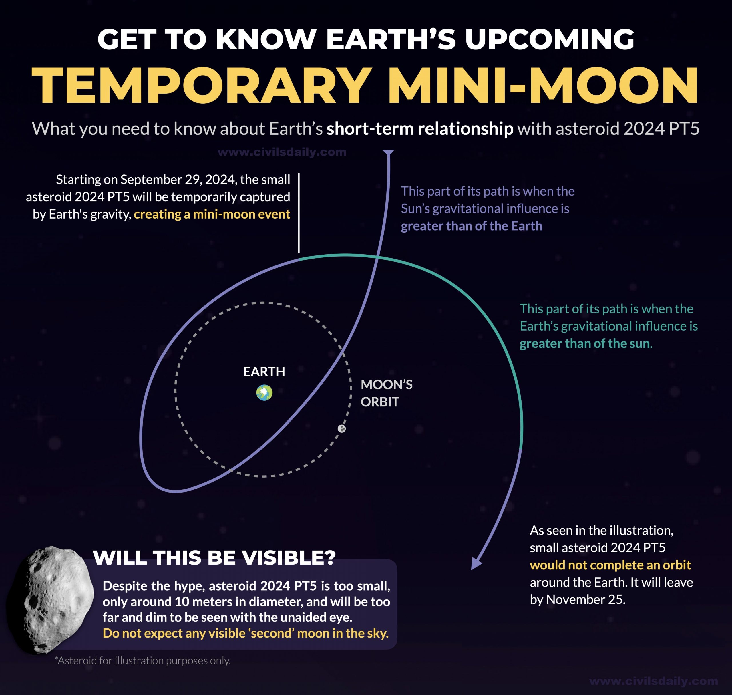
    In a rare celestial event, Earth’s gravitational field will witness a small asteroid, 2024 PT5, creating a “mini-moon” for two months.

    What is Mini-Moon?

    • A mini-moon is a small asteroid temporarily captured by Earth’s gravitational field, orbiting the planet for a short period before escaping back into space.
    • Unlike Earth’s permanent moon, mini-moons only stay for a few months to a few years before being ejected from orbit.
    • Mini-moons are a rare occurrence because most asteroids either pass by Earth or burn up in the atmosphere rather than being captured by Earth’s gravity.
    • Mini-moons are usually small, often just a few meters in diameter.
      • For example, 2024 PT5 is only about 33 feet (10 meters) in length.
    • They are hard to detect and are usually discovered using advanced telescopic surveys like NASA’s Asteroid Terrestrial-impact Last Alert System (ATLAS).

    Significance of Mini-Moons

    • Mini-moons offer scientists a unique opportunity to study near-Earth objects, enhancing our understanding of asteroids’ behavior and composition.
    • Mini-moons could contain valuable minerals or water, making them potential targets for future space missions to extract resources.
    • Studying mini-moons helps scientists learn more about Earth’s gravitational influence and how it interacts with space objects.

    PYQ:

    [2011] What is the difference between asteroids and comets?

    1. Asteroids are small rocky planetoids, while comets are formed of frozen gases held together by rocky and metallic material.
    2. Asteroids are found mostly between the orbits of Jupiter and Mars, while comets are found mostly between Venus and Mercury.
    3. Comets show a perceptible glowing tail, while asteroids do not.

    Which of the statements given above is/are correct?

    (a) 1 and 2 only
    (b) 1 and 3 only
    (c) 3 only
    (d) 1, 2 and 3