💥Join UPSC 2027,2028 Mentorship (July Batch) + XFactor Notes & Microthemes PDF

Subject: Geography

  • [pib] Effects of Himalayan slip on its Hydrology

    Researchers from the Indian Institute of Geomagnetism have found the mighty Himalayas subside and move up depending on the seasonal changes in groundwater.

    Tectonic activity and groundwater

    • The Himalayan foothills and the Indo-Gangetic plain are sinking because its contiguous areas are rising due to tectonic activity associated with landmass movement or continental drift.
    • The new study shows that subsidence and uplift are found to be associated with seasonal changes in groundwater, apart from the normal, common reasons.
    • Water acts as a lubricating agent, and hence when there is water in the dry season, the rate of the slip of the fault in this region is reduced.
    • In the Himalaya, seasonal water from glaciers, as well as monsoon precipitation, plays a key role in the deformation of the crust and the seismicity associated with it.
    • The subsidence rate is associated with groundwater consumption.

    Findings of the study

    • The researchers have made the combined use of GPS and Gravity Recovery And Climate Experiment (GRACE) data, which has made it possible for them to quantify the variations of hydrologic mass.
    • The GRACE satellites, launched by the US in 2002, monitor changes in water and snow stores on the continents.
    • The combined data suggest a 12% reduction in the rate of the subsurface slip. This slip refers to how fast the fault is slipping relative to the foot and hanging wall.
    • The slip occurs at the Main Himalayan Thrust (MHT), due to hydrological variations and human activities, over which there is the periodic release of accumulated strain.

    About GRACE Mission

    • The Gravity Recovery and Climate Experiment (GRACE) was a joint mission of NASA and the German Aerospace Center.
    • Twin satellites took detailed measurements of Earth’s gravity field anomalies from its launch in March 2002 to the end of its science mission in October 2017.
    • By measuring gravity anomalies, GRACE showed how mass is distributed around the planet and how it varies over time.


  • Explained: Cycle 25/ Solar Cycle


    The sunspots identified by researchers from IISER Kolkata herald the start of a new solar cycle called Cycle 25.

    What are Sunspots?

    • Sunspots are temporary phenomena on the Sun’s photosphere that appear as spots darker than the surrounding areas. They are relatively cooler spots on the Sun’s surface.
    • They are regions of reduced surface temperature caused by concentrations of magnetic field flux that inhibit convection.
    • Sunspots usually appear in pairs of opposite magnetic polarity with a leader and a follower.

    What is Solar Cycle?

    • From our safe distance of about 148 million km, the Sun appears to be sedate and constant. However, huge solar flares and coronal mass ejections spew material from its surface into outer space.
    • They originate from sunspots, an important phenomenon that people have been following for hundreds of years. They originate deep within the Sun and become visible when they pop out.
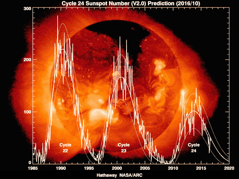
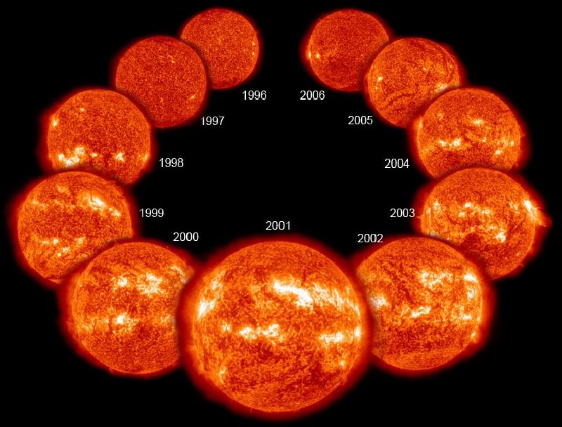
    • Their number is not constant but shows a minimum and then rises up to a maximum and then falls again in what is called the solar cycle.
    • Every 11 years or so, the Sun’s magnetic field completely flips. This means that the Sun’s north and south poles switch places. Then it takes about another 11 years for the Sun’s north and south poles to flip back again.
    • So far, astronomers have documented 24 such cycles, the last one ended in 2019.

    How do they occur?

    • Given the high temperatures in the Sun, matter exists there in the form of plasma, where the electrons are stripped away from the nuclei.
    • The Sun is made of hot ionized plasma whose motions generate magnetic fields in the solar interior by harnessing the energy of the plasma flows.
    • This mechanism is known as the solar dynamo mechanism (or magnetohydrodynamic dynamo mechanism).
    • Simply stated, it is a process by which kinetic energy of plasma motions is converted to magnetic energy, which generates the magnetised sunspots, giving rise to the solar cycle..
    • Because of the nature of the solar dynamo, the part of its magnetic field that gives rise to sunspots reverses direction when it moves from one solar cycle to another.
    • This can be inferred by observing when the relative orientation of the sunspot pairs flips.

    Features

    • The solar cycle affects activity on the surface of the Sun, such as sunspots which are caused by the Sun’s magnetic fields. As the magnetic fields change, so does the amount of activity on the Sun’s surface.
    • One way to track the solar cycle is by counting the number of sunspots.
    • The beginning of a solar cycle is a solar minimum, or when the Sun has the least sunspots. Over time, solar activity—and the number of sunspots—increases.
    • The middle of the solar cycle is the solar maximum, or when the Sun has the most sunspots. As the cycle ends, it fades back to the solar minimum and then a new cycle begins.
    • Giant eruptions on the Sun, such as solar flares and coronal mass ejections, also increase during the solar cycle. These eruptions send powerful bursts of energy and material into space.

    Impacts of Solar Cycle

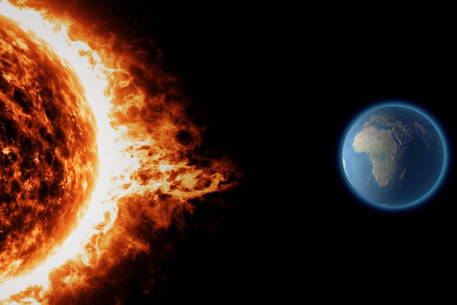
    • This activity has effects on Earth. For example, eruptions can cause lights in the sky, called aurora, or impact radio communications. Extreme eruptions can even affect electricity grids on Earth.
    • Solar activity can affect satellite electronics and limit their lifetime.
    • Radiation can be dangerous for astronauts who do work on the outside of the International Space Station.
    • Forecasting of the solar cycle can help scientists protect our radio communications on Earth, and help keep satellites and astronauts safe.

    Start of cycle 25

    • Following a weakening trend in activity over the last few cycles, there were predictions that the Sun would go silent into a grand minimum in activity, with the disappearance of cycles.
    • However, a team from IISER Kolkata has shown that there are signs that cycle 25 has just begun.
    • They used the data from the instrument Helioseismic and Magnetic Imager aboard NASA’s space-based Solar Dynamics Observatory for their calculations.

    Why is this so important to us on earth?

    • After all the sunspots look small and are hardly even visible to us. Contrary to this, sunspot activity may be correlated with climate on earth.
    • In the period between 1645 and 1715, sun spot activity had come to a halt on the Sun – a phenomenon referred to as the Maunder minimum.
    • This coincided with extremely cold weather globally. So sunspots may have a relevance to climate on earth.
    • Such links are tenuous, but definitely solar activity affects space weather, which can have an impact on space-based satellites, GPS, power grids and so on.
  • Solar Storms


    According to a research, sudden releases of high-energy particles from the sun, called solar storms, can mess with the navigational ability of gray whales, causing them to strand on land.

    Solar storms

    • Solar storms are a variety of eruptions of mass and energy from the solar surface.
    • Flares, prominences, sunspots, coronal mass ejections are the common harbingers of solar activity, as are plages and other related phenomena seen at other wavelengths.

    Impact on Whales

    • Solar storms have the potential to modify geomagnetic field and disrupt magnetic orientation behaviour of animals, hampering their navigation during long periods of migration.
    • They disrupt earth’s magnetic field — and the whales’ navigational sense.
    • The radio frequency noise created by the solar outburst affects the whales’ senses in a way that prevents them from navigating at all.
  • Yongle Blue Hole (YBH)


    Carbon more than 8,000 years old has been found inside the world’s deepest blue hole — the Yongle Blue Hole (YBH).

    Yongle Blue Hole (YBH)

    • The deepest known marine cavern is the Yongle blue hole, which measures roughly 300 metres from top to bottom.
    • Blue holes are marine caverns filled with water and are formed following dissolution of carbonate rocks, usually under the influence of global sea level rise or fall.
    • Its waters are mostly isolated from the surrounding ocean and receive little fresh water from rainfall, making it a rare spot to study the chemistry of oxygen-deprived marine ecosystems.
    • What distinguishes them from other aquatic caverns is that they are isolated from the ocean and don’t receive fresh rainwater.
    • They are generally circular, steep-walled and open to surface.

    Significance of YBH

    • YBH has a depth of 300 metres, far deeper than the previously recorded deepest blue hole, Dean’s Blue Hole in Bahamas, which had a depth of 202 metres.
    • However, like most blue holes, it is anoxic i.e. depleted of dissolved oxygen below a certain depth. This anaerobic environment is unfavorable for most sea life.
    • Such anoxic ecosystems are considered a critical environmental and ecological issue as they have led to several mass extinctions.
    • Concentrations of carbon, usually found in deep marine holes like YBH, provide a natural laboratory to study carbon cycling and potential mechanisms controlling it in the marine ecosystem.
    • The transition from aerobic to anaerobic environment adversely affects the biogeo-chemistry of the ocean.
  • Why do we have Leap Years?


    The year 2020 is a ‘leap year’, meaning the month of February will have 29 days instead of 28, and the total number of days will be 366 instead of 365. This was also the case in 2016, and 2024 will again be a leap year.

    Leap Years

    • A calendar is meant to correspond to the Earth’s seasons.
    • For this, the number of days in a calendar needs to match the time required by the Earth to orbit the Sun.
    • The time required by the Earth to complete its orbit around the Sun is approximately 365.242 days. But years are usually only 365 days.
    • To adjust for the extra 0.242 days in the orbital period, which becomes almost one full day in four years, the calendar adds an extra day once every four years.
    • This approximates the time to 365.25 days, which is close to the actual 365.242 days.

    But is that not inaccurate?

    • Yes, it is. And further adjustments are made to the Gregorian calendar, the calendar we follow today.
    • The Gregorian calendar was introduced in 1582. Before that, the calendar followed was the Julian calendar, introduced in 45 BC.
    • The calendars were different in their treatment of leap years.
    • The Julian calendar had leap days every four years, but since it still did not accurately conform to the Earth’s precise orbit time, it kept falling behind with respect to natural seasons over the centuries.
    • By the 16th century, the Julian calendar had fallen out of tune with the natural seasons by almost 10 days.
    • To correct this discrepancy, Pope Gregory XIII in 1582 decreed that the day of October 4 that year would be followed directly by October 15 – thus covering up the error.
    • The Pope also modified the leap year system in the Julian calendar. That new system came to be known as the Gregorian calendar.

    What is the new system?

    • In the Gregorian calendar, a century year (a year ending with 00) is not a leap year, even though it is a multiple of 4. Thus, the year 2100 will not be a leap year.
    • But even this does not provide total accuracy. To ensure that, some century years remain leap years. In the Gregorian calendar, leap years include those century years which are exactly divisible by 400.
    • Thus, 2000 remained a leap year even though it ended with 00.
    • The Gregorian calendar reduces the margin of error under the Julian calendar, thus keeping days more in tune with seasons.
  • Species in news: Thanatotheristes


    Scientists have found that a dinosaur fossil, found in Alberta in Canada in 2010, belongs to a new species of tyrannosaur. They have named it Thanatotheristes, which means “reaper of death”.

    Thanatotheristes

    • Tyrannosaurs were one of the largest meat-eating dinosaurs to have ever lived, with very large and high skulls, and the best known among them is the Tyrannosaurus rex, celebrated in the Jurassic Park series.
    • The 79-million-year-old fossil that the researchers have found is the oldest tyrannosaur known from northern North America.
    • Thanatotheristes preyed on large plant-eating dinosaurs such as the horned xenoceratops and the dome-headed colepiochephale.
    • The research suggests that tyrannosaurs did not have one general body type; rather different tyrannosaur species evolved distinct body sizes, skull forms and other such physical features.
    • The fossil specimen is important to understand the Late Cretaceous period, which is the period when tyrannosaurs roamed the Earth.
  • Explained: What new monsoon dates mean


    The India Meteorological Department (IMD) had decided to revise the normal onset and withdrawal dates for the monsoon in some parts of the country from this year.

    Onset of Monsoon

    • The four-month southwest monsoon season, which brings as much as 70 per cent of the country’s annual rainfall, officially begins on June 1, with the onset over Kerala, and ends on September 30.
    • It takes about a month and half after onset on the Kerala coast to cover the entire country; and about a month, beginning from the northwestern parts of the country on Sept. 1 to withdraw completely.
    • Although the June 1 date for the onset of the monsoon on the Kerala coast is unlikely to be changed, the dates for onset in many other parts of the country are expected to be revised.
    • Mumbai, for example, expects to start getting rain from June 10 the revision is likely to push this date back by a few days.
    • Effectively, the monsoon is now expected to have later arrival and withdrawal dates in most parts of the country.

    Why was this revision needed?

    • The main reason for the revision in the normal dates is the changes in precipitation patterns that have been taking place over the last many years.
    • In the last 13 years, for example, only once has the onset over the Kerala coast happened on June 1.
    • While two or three days of earlier or later onset falls within the yearly variability in several years the onset happened five to seven days late.
    • Similarly, the commencement of withdrawal has happened in the first week of September only twice during this period, and last year, the withdrawal started as late as October 9 — and was completed in around just a week.

    Recent peculiarity with the exam

    • One of the significant changes being noticed is that rainfall is getting increasingly concentrated within a narrow band of days within the monsoon season.
    • So, there are extremely wet days followed by prolonged periods of dry days.
    • IMD data show that over several previous years, nearly 95 per cent of monsoon precipitation in 22 major cities of the country had happened over a period of just three to 27 days.
    • Delhi, for example, had received almost 95 per cent of its monsoon rainfall over just 99 hours. And half of Mumbai’s monsoon rain had fallen over just 134 hours, or five and a half days, on average.

    Regional variations

    • Patterns of regional variations in rainfall are also changing
    • Areas that have traditionally received plenty of rainfall are often remaining dry, while places that are not expected to get a lot of monsoon rain have sometimes been getting flooded.
    • Climate change could be one of the factors driving these changes, but there could be other reasons as well.

    What will be the impact of IMD’s move?

    For Farmers

    • The revisions are meant to reflect the changes in precipitation patterns in recent years.
    • New dates will likely nudge farmers in some parts of the country to make slight adjustments in the time of sowing their crops.
    • It would definitely have an impact on our agriculture practices — when to start sowing, when to harvest.
    • So, even if there is a delay in the arrival of monsoon by three to four days over a region, it would not matter much if there is a fairly good rainfall distribution thereafter.
    • The change in dates would affect water management practices as well.

    For Industries

    • The planning that goes to beat the heat — several cities execute heat action plans — just ahead of the monsoon would have to factor in the need to be prepared for longer periods of heat.
    • Rajeevan said many other activities including industrial operations, the power sector, or those using cooling systems, would also need to change their behaviour.
    • The power grid can, for example, have more realistic planning for peak periods of electricity consumption in certain months.

    Way Forward

    • The changed dates are expected to be announced in April, when the IMD makes its first forecast for the monsoon.
    • Agro-meteorologists, however, agree that more than the onset, it is the information about the spatio-temporal distribution of rainfall that will be more helpful for farmers.
    • Ultimately, the change in normal dates of the onset and withdrawal of the monsoon would help people understand when to expect rains, and to plan their activities accordingly.
  • Eruption of Taal Volcano


    In the Philippines, a volcano called Taal on the island of Luzon; 50 km from Manila has recently erupted.

    Taal Volcano

    • Taal is classified as a “complex” volcano. Taal has 47 craters and four maars (a broad shallow crater).
    • It is situated at the boundaries of two tectonic plates — the Philippines Sea Plate and the Eurasian plate — it is particularly susceptible to earthquakes and volcanism.
    • A complex volcano, also called a compound volcano, is defined as one that consists of a complex of two or more vents, or a volcano that has an associated volcanic dome, either in its crater or on its flanks.
    • Examples include Vesuvius, besides Taal.
    • The Taal volcano does not rise from the ground as a distinct, singular dome but consists of multiple stratovolcanoes (volcanoes susceptible to explosive eruptions), conical hills and craters of all shapes and sizes.

    Threats posed

    • Taal’s closeness to Manila puts lives at stake. Manila is a few tens of kilometres away with a population of over 10 million.
    • The volcano is currently at alert level 4, which means that a “hazardous eruption” could be imminent within a few hours to a few days.
    • Hazardous eruptions are characterised by intense unrest, continuing seismic swarms and low-frequency earthquakes.

    Earlier records of eruption

    • Taal has erupted more than 30 times in the last few centuries. Its last eruption was on October 3, 1977.
    • An eruption in 1965 was considered particularly catastrophic, marked by the falling of rock fragments and ashfall.
    • Before that, there was a “very violent” eruption in 1911 from the main crater. The 1911 eruption lasted for three days, while one in 1754 lasted for seven months.
    • Because it is a complex volcano with various features, the kinds of eruption too have been varied. An eruption can send lava flowing through the ground, or cause a threat through ash in the air.
  • PM Modi’s 10-point agenda for renewing efforts towards disaster risk reduction

    source

    Dear Mitron,

    I welcome you all to New Delhi for this landmark conference, the first after the adoption of the Sendai Framework for Disaster Risk Reduction.

    First boley to maximum important for UPSC guys giving Prelims in 2017! Also research about Sendai Network and its predecessor. Kuch bhi pooch saktey hain.

    2015 was a momentous year! Apart from the Sendai Framework, the international community adopted two other major frameworks to shape the future of humanity:

    • – the Sustainable Development Goals,
    • – and the Paris Agreement on Climate Change

    For my UPSC Mitrons, make sure you have your notes made on both of them!

    Disaster Risk Reduction has a pivotal role in supporting adaptation to climate change as well as sustainable development.

    Use this line to flaunt your breadth of inter-connecting issues in your mains and essay papers!

    Seven of the top ten countries in the world in terms of number of deaths due to disasters are in the Asia-Pacific. That’s a heck of a statistic to have!

    A quarter century ago, only a handful of Asian nations had national disaster management institutions. Today, over thirty Asian countries have dedicated institutions leading disaster risk management efforts. After the Indian Ocean Tsunami of 2004, the five worst affected countries brought in new laws for disaster risk management.

    What has India done for Tsunami relief and preparedness?

    Hint: We now have a fully functional Indian Ocean Tsunami Warning System. Along with its Australian and Indonesian counterparts, the Indian National Centre for Ocean Information Services is mandated to issue regional tsunami bulletins.


    10 point agenda for renewing our efforts towards disaster risk reduction

    First, all development sectors must imbibe the principles of disaster risk management. This will ensure that all development projects – airports, roads, canals, hospitals, schools, bridges – are built to appropriate standards and contribute to the resilience of communities they seek to serve.

    In India, the ‘housing for all’ programme and ‘smart cities’ initiative represent such opportunities.

    Second, work towards risk coverage for all – starting from poor households to small and medium enterprises to multi-national corporations to nation states.

    In India, we have taken bold steps to ensure financial inclusion and risk insurance for the poorest. The Jan Dhan Yojana has brought millions of people into the banking system. The Suraksha Bima Yojana provides risk insurance to millions who need it the most. We have launched the Fasal Bima Yojana, which will provide risk cover to millions of farmers.

    Third, encourage greater involvement and leadership of women in disaster risk management. Women are disproportionately affected by disasters. They also have unique strengths and insights.

    Fourth, invest in risk mapping globally. For mapping risks related to hazards such as earthquakes we have widely accepted standards and parameters. Based on these, in India, we have mapped seismic zones, with five as highest seismic risk and two as low risk.

    Fifth, leverage technology to enhance the efficiency of our disaster risk management efforts

    What are the technological efforts/ inventions from India’s side on Disaster Reduction Plan?

    Sixth, develop a network of universities to work on disaster issues. After all, universities have social responsibilities too. Over the first five years of the Sendai Framework, we should develop a global network of universities working together on problems of disaster risk management.

    Seventh, utilize the opportunities provided by social media and mobile technologies. Social media is transforming disaster response. How so?

    Eighth, build on local capacity and initiative. The task of disaster risk management, particularly in rapidly growing economies, is so huge that formal institutions of the state can at best be instrumental in creating the enabling conditions.

    Can you give instances of local involvement in India’s case?

    Ninth, ensure that the opportunity to learn from a disaster is not wasted. After every disaster there are papers and reports on lessons learnt that are rarely applied.

    And finally, bring about greater cohesion in international response to disasters.


    In India, we are committed to walk the talk on the implementation of Sendai Framework. In June this year, India’s National Disaster Management Plan was released which is aligned with the priorities set out in the Sendai Framework.

    To read through related news on Disaster Management – Read this Newstrail

    To read more by Confused Billi – click here