💥Join UPSC 2027,2028 Mentorship (July Batch) + XFactor Notes & Microthemes PDF

Subject: Geography

  • [pib] River erosion in Ladakh Himalayas

    Indian researchers have studied rivers in Ladakh Himalaya, bringing out 35 thousand-year histories of river erosion and identified hotspots of erosion and wide valleys that act buffer zones.

    Click here to read more about the Himalayan river systems and its orogeny

    Erosion hotspot: Ladakh region

    • The Ladakh Himalaya forms a high altitude desert between Greater Himalayan ranges and Karakoram Ranges.
    • The Indus and its tributaries are major rivers flowing through the terrain.
    • The Zanskar River is one of the largest tributaries of the upper Indus catchment, draining orthogonally through highly deformed Zanskar ranges.

    Zanskar: A major river in Ladakh

    • Two prominent tributaries of Zanskar River are the Doda and Tsrap Lingti Chu, which confluence at Padam village in the upper valley to form the Zanskar River.
    • Zanskar catchment was explored to understand the landform evolution in the transitional climatic zone, using morpho-stratigraphy and study of landforms like valley fill terraces, alluvial fans (triangle-shaped deposit of gravel, sand, and even smaller pieces of sediment, such as silt).

    Zanskar Padam

    • Zanskar river makes a deep gorge in its lower reaches with the headwaters in upper Zanskar makes wide basin called as Padam.
    • The basin stores large amount of sediments in form of fans and river terrace deposits
    • The research suggested that the wide valley of Padam, with an area of 48 square km, in the upper Zanskar, has stored a vast amount of sediments in these landforms.
    • Thus Padam valley is a hotspot of sediment buffering in the Zanskar.

    Sediment study reveals the erosion

    • The study suggested that most sediments were derived from Higher Himalayan crystalline that lies in the headwater region of Zanskar.
    • It was found out that dominant factors responsible for sediment erosion were deglaciation and Indian Summer Monsoon derived precipitation in the headwaters despite the presence of a geomorphic barrier (the deep, narrow gorge).

    Significance of the study

    • The scientists have traced where the rivers draining Himalaya and its foreland erode the most and identify the zones that receive these eroded sediments and fill up.
    • The study will help understand river-borne erosion and sedimentation, which are the main drivers that make large riverine plains, terraces, and deltas that eventually become the cradle to evolving civilizations.
    • It will also help study the dynamics of devastating floods created by these Himalayan rivers in recent times.
    • Thus, the understanding of water and sediment routing becomes crucial while developing infrastructure and for other development works in the river catchment area.
  • New list of names of tropical cyclones over north Indian Ocean

    The India Meteorological Department (IMD) has released a new list containing 169 names of future tropical cyclones that would emerge in the Bay of Bengal and the Arabian Sea.

    When is the name of a Tropical Cyclone declared?

    • Names are declared when TCs are diagnosed with maximum sustained surface wind-speed of 34 knots (62 kmph) or more as per Global Data Processing and Forecasting System (GDPFS) Manual of WMO.
    • Panel Members’ names will be listed alphabetically country-wise.

    We can expect a statement based prelim question like – Which of the following criterion are followed while naming a tropical cyclone?

    Who is involved in the naming of Tropic Cyclone?

    • Worldwide there are six regional specialised meteorological centres (RSMCs) and five regional Tropical Cyclone Warning Centres (TCWCs) mandated for issuing advisories and naming of tropical cyclones.
    • IMD is one of the six RSMCs to provide tropical cyclone and storm surge advisories to 13 member countries under WMO/ESCAP Panel.
    • The panel countries include Bangladesh, India, Iran, Maldives, Myanmar, Oman, Pakistan, Qatar, Saudi Arabia, Sri Lanka, Thailand, United Arab Emirates and Yemen.
    • RSMC, New Delhi is also mandated to name the Tropical Cyclones developing over the North Indian Ocean (NIO) including the Bay of Bengal and the Arabian Sea.

    Since when did naming begin?

    • The WMO/ESCAP Panel on Tropical Cyclones (PTC) at its twenty-seventh Session held in 2000 in Muscat, agreed in principle to assign names to the tropical cyclones in the Bay of Bengal and the Arabian Sea.
    • After long deliberations among the member countries, the naming of the tropical cyclones over the north Indian Ocean commenced from September 2004.
    • This list contained names proposed by the eight member countries of WMO/ESCAP PTC, viz., Bangladesh, India, Maldives, Myanmar, Oman, Pakistan, Sri Lanka and Thailand.

    Why name Cyclones?

    The naming of Tropical Cyclones (TC) helps the scientific community, disaster managers, media and general masses to-

    • identify each individual cyclone.
    • create awareness of its development.
    • remove confusion in case of simultaneous occurrence of TCs over a region
    • remember a TC easily
    • rapidly and effectively disseminate warnings to a much wider audience

    Major criteria adopted for naming

    • The proposed name should be neutral to (a) politics and political figures (b) religious believes, (c) cultures and (d) gender
    • The name should be chosen in such a way that it does not hurt the sentiments of any group of the population over the globe
    • It should not be very rude and cruel in nature
    • The maximum length of the name will be eight letters
    • The Panel reserves the right to reject any name if any of the criteria above are not satisfied
    • The names of tropical cyclones over the north Indian Ocean will not be repeated. Once used, it will cease to be used again.

    Back2Basics

    https://www.civilsdaily.com/news/explained-naming-of-cyclones/

  • Rohtang Pass and its location

    The Border Roads Organisation (BRO) has opened the Rohtang Pass, three weeks in advance, for transporting essential supplies and relief materials to Lahaul and Spiti districts of Himachal Pradesh.

     Rohtang Pass

    • It is a high mountain pass (elevation 3,980 m) on the eastern Pir Panjal Range of the Himalayas around 51 km from Manali.
    • It connects the Kullu Valley with the Lahaul and Spiti Valleys of Himachal Pradesh, India.
    • The pass lies on the watershed between the Chenab and Beas basins.
    • On the southern side of this pass, the Beas River emerges from underground and flows southward and on its northern side, the Chandra River, a source stream of the river Chenab, flows westward.

    Another pass in new:

    https://www.civilsdaily.com/news/sela-pass-tunnel-project/

  • Daporijo Bridge and its significance

    A key bridge over the Subansiri River in Arunachal Pradesh close to the Line of Actual Control (LAC) was constructed by the Border Roads Organisation (BRO) in record 27 days.

    North-East has seen the construction of a series of bridges by BRO in recent times post-Doklam standoff. Make a note of all such bridges and the corresponding rivers over which they are built.

     Daporijo Bridge

    • This Bridge is one of the two over River Subansiri which connect Daporji in North Subansiri dist. with rest of state.
    • This and the other bridge at Tamin sustaining more than 600 villages and troops strength of around 3000 personnel manning the LAC which includes disputed Areas of Asaphila and Maza.
    • All supplies, rations, constructional material and medicines pass over this bridge.
    • The new bridge now can withstand 40 tonnes of weight allowing a safe passage for heavier vehicles catering for the requirements of the Indian Army as well as future infrastructure development requirements.

    Significance

    • India has speeded up the construction of critical infrastructure in its northeast in the past half a dozen years including airports, railways and roads with an eye on China that has motorable roads right up to the border.
    • Arunachal Pradesh was the scene of the 1962 India-China border conflict that ended badly for India. China on its parts claims all of the state as “Southern Tibet.”
    • Of the 3488 km long Line of Actual Control with China 1126 lies with Arunachal Pradesh alone.
    • The two countries are yet to demarcate their border with the two sides patrolling the LAC but reporting incursions by the other side since the frontier is not clearly marked.
  • Matterhorn Mountain of the Swiss Alps

    Switzerland has expressed solidarity with India in its fight against the coronavirus pandemic by projecting the tricolour on the famous Matterhorn Mountain in the Swiss Alps.

    It has been long time since a question on global mountains/mountain ranges has not been asked in the prelims. Gear up for the uncertainty. Make a special sheet of geographical locations in news.

    Mt. Matterhorn

    • The Matterhorn is a mountain of the Alps, separating the main watershed and border between Switzerland and Italy.
    • It is a large, near-symmetric pyramidal peak in the extended Monte Rosa area of the Pennine Alps, whose summit is 4,478 metres.
    • It is one of the highest summits in the Alps and Europe (Mont Blanc being highest).
    • The four steep faces, rising above the surrounding glaciers, face the four compass points and are split by the Hörnli, Furggen, Leone/Lion, and Zmutt ridges.

    Its formation

    • The Matterhorn is mainly composed of gneisses originally fragments of the African Plate before the Alpine orogeny.
    • The mountain’s current shape is the result of cirque erosion due to multiple glaciers diverging from the peak, such as the Matterhorn Glacier at the base of the north face.

    Back2Basics: Alps mountain range

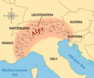
    • The Alps are the highest and most extensive mountain range system that lies entirely in Europe.
    • It stretches approximately 1,200 kilometres across eight Alpine countries (from west to east): France, Switzerland, Monaco, Italy, Liechtenstein, Austria, Germany, and Slovenia.
    • The mountains were formed over tens of millions of years as the African and Eurasian tectonic plates collided.
    • Extreme shortening caused by the event resulted in marine sedimentary rocks rising by thrusting and folding into high mountain peaks such as Mont Blanc and the Matterhorn.
    • Mont Blanc spans the French–Italian border, and at 4,809 m (15,778 ft) is the highest mountain in the Alps.
  • Earth’s seismic noise levels

    Scientists at the British Geological Survey (BGS) reported a change in the Earth’s seismic noise and vibrations amid the coronavirus lockdown. This change has been monitored through a space-based seismograph.

    Ever heard of space-based monitoring of seismic activities?  This topic creates a scope for potential prelims question…

    What is seismic noise?

    • In geology, seismic noise refers to the relatively persistent vibration of the ground due to a multitude of causes.
    • It is the unwanted component of signals recorded by a seismometer– the scientific instrument that records ground motions, such as those caused by earthquakes, volcanic eruptions, and explosions.
    • This noise includes vibrations caused due to human activity, such as transport and manufacturing, and makes it difficult for scientists to study seismic data that is more valuable.
    • Apart from geology, seismic noise is also studied in other fields such as oil exploration, hydrology, and earthquake engineering.

    How are vibrations generated?

    • We measure ground vibrations from earthquakes using seismometers.
    • These are incredibly sensitive so they also pick up other sources of vibration too, including human activity, such as road traffic, machinery and even people walking past.
    • All these things generate vibrations that propagate as seismic waves through the Earth.

    Reasons for the decline

    • Due to the enforcement of lockdown measures around the world to tackle the novel coronavirus pandemic, the Earth’s crust has shown reduced levels of vibration.

    How do the reduced noise levels help scientists?

    • The seismic noise vibrations caused by human activity are of high frequency (between 1-100 Hz), and travel through the Earth’s surface layers.
    • Usually, to measure seismic activity accurately and reduce the effect of seismic noise, geologists place their detectors 100 metres below the Earth’s surface.
    • However, since the lockdown, researchers were able to study natural vibrations even from surface readings, owing to lesser seismic noise.
    • Due to lower noise levels, scientists are now hoping that they would be able to detect smaller earthquakes and tremors that had slipped past their instruments so far.


  • Armed Forces: their role during crisis, procedures for requisition

    As the Army moves in to take over the COVID-19 quarantine facility in Delhi, the procedure for calling the armed forces to help the civil administration is in the spotlight.

    Requisition the Army

    • The regulations permit civil authorities to requisition the Army for controlling law and order, maintaining essential services, assisting during natural calamities such as earthquakes, and any other type of help that may be needed by the civil authorities.
    • The procedure for requisitioning armed forces is governed under several guidelines including:
    1. ‘Aid to Civil Authorities’ under the guidelines laid in Instructions on Aid to the Civil Authorities by the Armed Forces, 1970;
    2. Regulations for the Army, Chapter VII, Paragraphs 301 to 327 and
    3. Manual of Indian Military Law, Chapter VII

    How is Army invited?

    • Civil administration requests the Local Military Authority for assistance, for the maintenance of law and order, maintenance of essential services, disaster relief and other types of assistance.
    • Armed forces can be asked to provide troops and equipment for a flag march, rescue and relief, evacuation, and immediate aid.
    • The current case of checking the spread of COVID-19 is different, as the medical aspect is predominant.
    • These resources are being controlled centrally and judiciously, because of the requirement of doctors, equipment and facilities.

    Why need Armed forces in such situations?

    • Besides the specialised medical resources, which are centrally controlled, the local units are prepared for maintenance of law and order, crowd control, curfew in sensitive areas etc.
    • Moreover provision of essential supply of electricity and water, restoration of essential services, emergency feeding and shelter, prevention of panic, prevention of theft and loot are other areas of concerns.
    • During such multi-faceted challenges, local authorities have shortfall to perform all such functions.

    In such situations, what happens to the armed forces’ primary role?

    • Providing aid to civil authorities, as and when called upon to do so, is a secondary task for the armed forces.
    • It cannot replace the primary role of ensuring external security and operational preparedness.

    Is there a ceiling on such deployment?

    • No, there is no such ceiling either of a duration of deployment or on the number of armed forces personnel that can be deployed to aid civil authority.
    • The National Crisis Management Committee (NCMC), headed by the cabinet secretary, is the final authority.

    Are there any templates or instances from the past that are applicable here?

    • The current situation is different from earlier cases such as tsunami or super-cyclone, which were natural disasters.
    • The major difference is that specialists are the key in the current situation, and their tasks cannot be performed by general duty soldiers.

    Who pays for the costs incurred?

    • The civil administration is responsible for the costs incurred by the armed forces in these roles.
    • The cost of assistance provided by the Armed Forces is recovered in accordance with the instructions contained in ‘Instructions on Aid to Civil Authorities by the Armed Forces 1970’.

    What is the role of the National Disaster Management Authority?

    • NDMA is involved in secondary follow-ups by the Home Ministry and is not very actively involved in the current case.
    • The roles of the Ministries of Health, Home, Civil Aviation and Defence are predominant in this case.
    • The armed forces are aligned with them at the apex level viz NCMC.
    • The directions are followed by execution-level coordination which is done by respective secretaries in the government.
  • Prime Minister’s National Relief Fund (PMNRF)

    Keeping in view the novel coronavirus crisis across the country, various govt. employees, celebrities and political dignitaries are open-heartedly contributing to the PM’s National Relief Fund (PMNRF) to help combat the disease.

    PM’s National Relief Fund (PMNRF)

    • In pursuance of an appeal by the then PM, Pt. Nehru in January, 1948, the Prime Minister’s National Relief Fund (PMNRF) was established with public contributions.
    • It was aimed to assist displaced persons from Pakistan.
    • The resources of the PMNRF are now utilized primarily to render immediate relief to families of those killed in natural calamities like floods, cyclones and earthquakes, etc. and to the victims of the major accidents and riots.
    • Assistance from PMNRF is also rendered, to partially defray the expenses for medical treatment like heart surgeries, kidney transplantation, cancer treatment and acid attack etc.
    • The fund consists entirely of public contributions and does not get any budgetary support.

    Legal status

    • PMNRF has not been constituted by the Parliament.
    • The fund is recognized as a Trust under the Income Tax Act and the same is managed by PM or multiple delegates for national causes.

    Donations

    • PMNRF accepts only voluntary donations by individuals and institutions.
    • Contributions flowing out of budgetary sources of Government or from the balance sheets of the public sector undertakings are not accepted.
    • Conditional contributions, where the donor specifically mentions that the amount is meant for a particular purpose, are not accepted in the Fund.

    Its operation

    • PMNRF operates from the Prime Minister’s Office and does not pay any license fee.
    • PM is the Chairman of PMNRF and is assisted by Officers/ Staff on an honorary basis. Permanent Account Number of PMNRF is AACTP4637Q.

    Tax exemptions

    • PMNRF is exempt under the Income Tax Act, 1961 under Section 10 and 139 for return purposes.
    • Contributions towards PMNRF are notified for 100% deduction from taxable income under section 80(G) of the Income Tax Act, 1961.
  • Explained: Notified Disaster

    The Ministry of Home Affairs has decided to treat COVID-19 as a notified disaster for the purpose of providing assistance under the State Disaster Response Fund (SDRF).

    What is a Disaster?

    According to the Disaster Management Act, 2005 a disaster is defined as-

    • A catastrophe, mishap, calamity or grave occurrence in any area, arising from natural or manmade causes, or by accident or negligence which results in substantial loss of life or human suffering or damage to, and destruction of, property, or damage to, or degradation of, environment, and is of such a nature or magnitude as to be beyond the coping capacity of the community of the affected area.
    • The MHA has defined a disaster as an “extreme disruption of the functioning of a society that causes widespread human, material, or environmental losses that exceed the ability of the affected society to cope with its own resources.

    What is the State Disaster Response Fund?

    • The SDRF is constituted under the Disaster Management Act, 2005 and is the primary fund available with state governments for responses to notified disasters.
    • The Central government contributes 75 per cent towards the SDRF allocation for general category states and UTs, and over 90 per cent for special category states/UTs (which includes northeastern states, Sikkim, Himachal Pradesh and Uttarakhand).
    • For SDRF, the Centre releases funds in two equal instalments as per the recommendation of the Finance Commission.
    • The disasters covered under the SDRF include cyclones, droughts, tsunamis, hailstorms, landslides, avalanches and pest attacks among others.

    The NDRF

    The National Disaster Response Fund, which is also constituted under the Disaster Management Act, 2005 supplements the SDRF of a state, in case of a disaster of severe nature, provided adequate funds are not available in the SDRF.

    Categories of disaster

    • A High Power Committee on Disaster Management was constituted in 1999 to identify disaster categories.
    • It identified 31 disaster categories organised into five major subgroups, which are: water and climate-related disasters, geological related disasters, chemical, industrial and nuclear-related disasters and biological related disasters, which includes biological disasters and epidemics.

    Have there been such instances in the past?

    • In 2018, in view of the devastation caused by the Kerala floods, political leaders in Kerala demanded that the floods be declared a “national calamity”.
    • As of now, there is no executive or legal provision to declare a national calamity.
    • In 2001, the National Committee on Disaster Management under then PM was mandated to look into the parameters that should define a national calamity.
    • However, the committee did not suggest any fixed criterion.
    • In the past, there have been demands from states to declare certain events as natural disasters, such as the Uttarakhand flood in 2013, Cyclone Hudhud in Andhra Pradesh in 2014, and the Assam floods of 2015.
  • Earth’s spin has slowed over time


    Earth spun 372 times a year 70 million years ago, compared to the current 365. This means the day was 23½ hours long, compared to 24 today.

    Faster Earth in the olden days

    • It has long been known that Earth’s spin has slowed over time.
    • Previous climate reconstructions, however, have described long-term changes over tens of thousands of years.
    • The new study looked at daily and annual variations in the mollusc shell.

    About the Mollusc

    • A mollusc is an invertebrate of a large phylum which includes snails, slugs, mussels, and octopuses. They have a soft unsegmented body and live in aquatic or damp habitats, and most kinds have an external calcareous shell.
    • The ancient mollusc, Torreites Sanchez, belonged to an extinct group called rudist clams.
    • At 70 million years ago, it belonged to the Late Cretaceous — it was around the time this epoch ended, some 65 million years ago, that dinosaurs went extinct.

    How did researchers conclude this variation?

    • Torreites sanchezi grew very fast, laying down daily growth rings.
    • Using lasers on a single individual, scientists sampled tiny slices and counted the growth rings accurately.
    • This allowed them to determine the number of days in a year 70 million years ago, and more accurately calculate the length of a day.

    Significance of the research

    • It is important to note that the period of Earth’s orbit has remained the same. In other words, one year 70 million years ago was as long as one year today.
    • However, if there were a calendar then, the year would have been 372 “days” long, with each “day” half-an-hour shorter than one day today.
    • Today, Earth’s orbit is not exactly 365 days, but 365 days and a fraction, which is why our calendars have leap years, as a correction.

    The Moon’s retreat

    • Friction from ocean tides, caused by the Moon’s gravity, slows Earth’s rotation and leads to longer days.
    • And as Earth’s spin slows the Moon moves farther away at 3.82 cm per year.
    • If this rate is projected back in time, however, the Moon would be inside the Earth only 1.4 billion years ago.
    • This new measurement, in turn, informs models of how the Moon formed and how closes it has been to Earth over their 4.5-billion-year gravitational relationship.