💥Join UPSC 2027,2028 Mentorship (August Batch) + XFactor Notes & Microthemes PDF

Subject: Space Technology

  • 2001 FO32: the largest asteroid passing by Earth

    On March 21, the largest asteroid predicted to pass by Earth in 2021 will be at its closest. It is called 2001 FO32.

    Try this PYQ:

    Q.Which of the following is/are cited by the scientists as evidence/evidence for the continued expansion of the universe?

    1. Detection of microwaves in space
    2. Observation of redshirt phenomenon in space
    3. Movement of asteroids in space
    4. Occurrence of supernova explosions in space

    Codes:

    (a) 1 and 2 only

    (b) 2 only

    (c) 1, 3 and 4

    (d) None of the above can be cited as evidence.

    2001 FO32

    • There is no threat of a collision with our planet now or for centuries to come.
    • Scientists know its orbital path around the Sun very accurately since it was discovered 20 years ago and has been tracked ever since.
    • It won’t come closer than 2 million km to Earth, but it will present a valuable scientific opportunity for astronomers who can get a good look at a rocky relic that formed at the dawn of our Solar System.

    Proximity to Earth

    • For comparison, when it is at its closest, the distance of 2 million km is equal to 5¼ times the distance from Earth to the Moon.
    • Still, that distance is close in astronomical terms, which is why 2001 FO32 has been designated a “potentially hazardous asteroid”.
    • The reason for the asteroid’s unusually speedy close approach is its highly eccentric orbit around the Sun, an orbit that is tilted 39° to Earth’s orbital plane.
    • This orbit takes the asteroid closer to the Sun than Mercury, and twice as far from the Sun as Mars.
    • Later, the asteroid slows after being flung back out into deep space and swinging back toward the Sun. It completes one orbit every 810 days (about 2¼ years).

    Studying the visitor

    • This asteroid will provide an opportunity for astronomers to get a more precise understanding of the asteroid’s size and albedo (i.e. how bright, or reflective, its surface is), and a rough idea of its composition.
    • When sunlight hits an asteroid’s surface, minerals in the rock absorb some wavelengths while reflecting others.
    • By studying the spectrum of light reflecting off the surface, astronomers can measure the chemical “fingerprints” of the minerals on the surface of the asteroid.
  • Lunar Polar Exploration (LUPEX) Mission

    India and Japan are working together on a joint lunar polar exploration (LUPEX) mission that aims to send a lander and rover to the Moon’s the South Pole around 2024.

    Try this PYQ from CSP 2020:

    Q.The experiment will employ a trio of spacecraft flying in formation in the shape of an equilateral triangle that has sides one million km long, with lasers shining between the craft.” the experiment in the question refers to?

    (a) Voyager-2

    (b) New horizons

    (c) LISA pathfinder

    (d) Evolved LISA

    LUPEX Mission

    • The LUPEX is a robotic lunar mission concept by the Indian Space Research Organisation (ISRO) and Japan Aerospace Exploration Agency (JAXA).
    • It would send a lunar rover and lander to explore the South Pole region of the Moon in 2024.
    • JAXA is likely to provide the under-development H3 launch vehicle and the rover, while ISRO would be responsible for the lander.
    • The mission concept has not yet been formally proposed for funding and planning.
    • The Lunar Polar Exploration mission would demonstrate new surface exploration technologies related to vehicular transport and lunar night survival for sustainable lunar exploration in Polar Regions.
  • NASA-ISRO Synthetic Aperture Radar (NISAR)

    Indian Space Research Organisation (ISRO) has completed the development of a Synthetic Aperture Radar (SAR).

    Note the key features of the Mission. Every statement has a unique information.

    NASA-ISRO SAR

    • NISAR is a joint collaboration for a dual-frequency L and S-band SAR for earth observation.
    • NASA and Bengaluru-headquartered ISRO signed a partnership on September 30, 2014, to collaborate on and launch NISAR.
    • The mission is targeted to launch in early 2022 from ISRO’s Sriharikota spaceport in Andhra Pradesh’s Nellore district, about 100km north of Chennai.
    • It is capable of producing extremely high-resolution images for a joint earth observation satellite mission with NASA.
    • It will be the first satellite mission to use two different radar frequencies (L-band and S-band) to measure changes in our planet’s surface less than a centimetre across.

    Objectives of the NISAR

    • NISAR will observe Earth’s land and ice-covered surfaces globally with 12-day regularity on ascending and descending passes, sampling Earth on average every six days for a baseline three-year mission.
    • It will measure Earth’s changing ecosystems, dynamic surfaces and ice masses, providing information about biomass, natural hazards, sea-level rise and groundwater, and will support a host of other applications.
    • It would also provide data on natural hazards including earthquakes, tsunamis, volcanoes and landslides.

    What are L and S Bands?

    • L band waves are used for GPS units because they are able to penetrate clouds, fog, rain, storms, and vegetation.
    • The S-band is used by airport surveillance radar for air traffic control, weather radar, surface ship radar, and some communications satellites, especially those used by NASA to communicate with the Space Shuttle and the International Space Station.
    • NISAR uses a sophisticated information-processing technique known as SAR to produce extremely high-resolution images.
    • Radar penetrates clouds and darkness, enabling NISAR to collect data day and night in any weather.

    What is collaboration?

    • NASA is providing the mission’s L-band SAR, a high-rate communication subsystem for science data, GPS receivers, a solid-state recorder and payload data subsystem.
    • ISRO is providing the spacecraft bus, the S-band radar, the launch vehicle and associated launch services for the mission, whose goal is to make global measurements of the causes and consequences of land surface changes using advanced radar imaging.
  • What are Quasars?

    An international team of astronomers have discovered the most distant ‘radio-loud’ quasar with the help of the European Southern Observatory’s Very Large Telescope (ESO’s VLT).

    Ever found this on YouTube? Take time to watch this amazing video. It will literally blow up your mind and curiosity!


    TIMELAPSE OF THE FUTURE: A Journey to the End of Time (4K)


    This video will make up your perceptions and conceptions of how a galaxy dies after the sun runs out of fuel and what a black hole actually is!

    What are Quasars?

    • A quasar known as a quasi-stellar object is an extremely luminous active galactic nucleus (AGN), in which a supermassive black hole with mass ranging from millions to billions of times the mass of the Sun is surrounded by a gaseous accretion disk.
    • As gas in the disk falls towards the black hole, energy is released in the form of electromagnetic radiation, which can be observed across the electromagnetic spectrum.
    • The power radiated by quasars is enormous; the most powerful quasars have luminosities thousands of times greater than a galaxy such as the Milky Way.
    • Most active galaxies have a supermassive black hole at the centre which sucks in surrounding objects.
    • Quasars are formed by the energy emitted by materials spiralling around a black hole right before being sucked into it.

    What makes this event special?

    • 90 per cent of quasars do not emit strong radio waves, making this newly-discovered one special.
    • It took 13 billion years for the quasar’s light to reach earth.
    • Named P172+18, the quasar emitted wavelengths had a redshift of 6.8.
    • Only three other ‘radio-loud’ sources with a redshift greater than six have been discovered so far and the most distant one had a redshift of 6.18.
    • The higher the redshift of the radio wavelength, the farther away is the source.

    As an object moves away from us, the sound or light waves emitted by the object are stretched out, which makes them have a lower pitch and moves them towards the red end of the electromagnetic spectrum, where light has a longer wavelength. In the case of light waves, this is called redshift.

  • [pib] Devasthal Optical Telescope

    Indian Scientists have indigenously designed and developed a low-cost optical spectrograph called Devasthal Optical Telescope (DOT).

    Devasthal Optical Telescope

    • The ‘Made in India’ optical spectrograph is named as Aries-Devasthal Faint Object Spectrograph & Camera (ADFOSC).
    • It is indigenously designed and developed by Aryabhatta Research Institute of Observational Sciences (ARIES), Nainital.
    • DOT locates sources of faint light from distant quasars and galaxies in a very young universe, regions around supermassive black-holes around the galaxies, and cosmic explosions.
    • Such spectroscopes were so far imported from abroad involved high costs.

    Try this PYQ:

    Q.“Event Horizon” is related to:

    (a) Telescope

    (b) Black hole

    (c) Solar glares

    (d) None of the above

    Special features

    • It is about 2.5 times less costly compared to the imported ones and can locate sources of light with a photon-rate as low as about 1 photon per second.
    • It has been successfully commissioned on the 3.6-m Devasthal Optical Telescope (DOT), the largest in the country and in Asia, near Nainital Uttarakhand.
    • This instrument uses a complex arrangement of several lenses made of special glasses, polished to better than 5-nanometer smoothness to produce sharp images of the celestial sky.
    • Photons coming from distant celestial sources, collected by the telescope, are sorted into different colours by the spectrograph and are finally converted into electronic recordable signals.
    • It uses an in-house developed Charge-Coupled Device (CCD) camera cooled to an extremely low temperature of -120 0
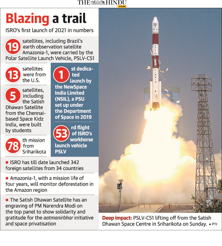
  • ISRO places Brazil’s Amazonia-1 satellite

    The successful launch of Brazil’s Amazonia-1 satellite by the Indian Space Research Organisation marks a new high point in space cooperation between the two countries.

    Note why Amazonia-1 Satellite is distinct in itself. It paves for statement based MCQs.

    Amazonia-1 Satellite

    • The Amazônia-1 or SSR- is the first Earth observation satellite entirely developed by Brazil.
    • It is optimized to peer at the cloud-covered region of its namesake, the Amazon forest since it has infrared capabilities that allow it to look at the forest cover regardless of the weather.
    • Brazil plans to use the satellite to “alert deforestation” in the region, Brazil’s National Institute for Space Research (INPE) said in an Amazonia 1 mission description.

    Significance of the launch

    • This confirms the infinite potential of the India-Brazil partnership to overcome our development challenges through high technology.
    • The launch also marked the first dedicated mission of ISRO’s commercial arm NewSpace India Ltd. (NSIL).
  • [pib] Sun’s Rotation over the Century

    Scientists at Kodaikanal Solar Observatory have estimated how the Sun has rotated over a century from data extracted from old films and photographs that have been digitized.

    Try this PYQ:

    Q.Consider the following phenomena:

    1. Size of the sun at dusk
    2. Colour of the sun at dawn
    3. Moon being visible at dawn
    4. Twinkle of stars in the sky
    5. Polestar being visible in the sky

    Which of the above are optical illusions?

    (a) 1, 2 and 3

    (b) 3, 4 and 5

    (c) 1, 2 and 4

    (d) 2, 3 and 5

    Sun’s Rotation

    • The Sun rotates around an axis that is roughly perpendicular to the plane of the ecliptic; the Sun’s rotational axis is tilted by 7.25° from perpendicular to the ecliptic.
    • It rotates in the counterclockwise direction (when viewed from the north), the same direction that the planets rotate (and orbit around the Sun).
    • The Sun’s rotation period varies with latitude on the Sun since it is made of gas.
    • Equatorial regions rotate faster than Polar Regions.
    • The equatorial regions (latitude = 0 degrees) rotate in about 25.6 days. The regions at 60 degrees latitude rotate in about 30.9 days. Polar Regions rotate in about 36 days.

    Key observations of the study

    • The Sun rotates more quickly at its equator than at its poles.
    • Over time, the Sun’s differential rotation rates cause its magnetic field to become twisted and tangled.
    • The tangles in the magnetic field lines can produce strong localized magnetic fields.
    • When the Sun’s magnetic field gets twisted, there are lots of sunspots.
    • The sunspots which form at the surface with an 11-year periodicity are the only route to probe the solar dynamo or solar magnetism inside the Sun and hence measure the variation in solar rotation.

    Benefits offered

    • This estimation would help study the magnetic field generated in the interior of the Sun, which causes sunspots and results in extreme situations like the historical mini-ice age on Earth (absence of sunspots).
    • It could also help predict solar cycles and their variations in the future.
  • NASA’s Perseverance rover makes historic Mars landing

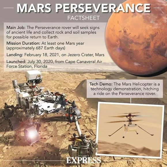
    NASA’s rover Perseverance, the most advanced astrobiology laboratory ever sent to another world has landed safely on the floor of Jezero Crater on Mars.

    Last week, separate probes launched by the UAE (Hope Mission) and China (Tianwen-1) reached Martian orbit. NASA has three Mars satellites still in orbit, along with two from the European Space Agency.

    Perseverance Rover

    • The Perseverance rover weighs less than 2,300 pounds and is managed by NASA’s Jet Propulsion Lab.
    • It is a part of the mission named ‘Mars 2020’.
    • The rover’s mission will be to search for signs of past microbial life. It will also collect samples of Martian rocks and dust, according to the release.
    • All of NASA’s previous Mars rovers — including the Sojourner (1997), Spirit and Opportunity (2004) and Curiosity (exploring Mars since 2012) — were named in this way.

    Objectives of the mission

    • Looking for habitability: identify past environments capable of supporting microbial life.
    • Seeking bio-signatures: seek signs of possible past microbial life in those habitable environments, particularly in special rocks known to preserve signs over time.
    • Caching samples: collect core rock and regolith (“soil”) samples and store them on the Martian surface.
    • Preparing for humans: test oxygen production from the Martian atmosphere.

    Major components

    (a) Looking for underground water

    • Perseverance will carry the Radar Imager for Mars’ Subsurface Experiment (RIMFAX).
    • The instrument will look for subsurface water on Mars – which, if found, will greatly help the case for a human mission or the cause of a human settlement on Mars.

    (b) Testing a helicopter

    • The Mars Helicopter is a small drone. It is a technology demonstration experiment: to test whether the helicopter can fly in the sparse atmosphere on Mars.
    • The low density of the Martian atmosphere makes the odds of actually flying a helicopter or an aircraft on Mars very low.

    (c) Producing oxygen on Mars

    • Perseverance will have an instrument – MOXIE, or Mars Oxygen In-Situ Resource Utilization Experiment – that will use 300 watts of power to produce about 10 grams of oxygen using atmospheric carbon dioxide.
    • Should this experiment be successful, MOXIE can be scaled up by a factor of 100 to provide the two very critical needs of humans: oxygen for breathing, and rocket fuel for the trip back to Earth.
  • Govt liberalized Geospatial Data Policy

    In sweeping changes to the country’s mapping policy, the government has announced liberalisation of norms governing the acquisition and production of geospatial data.

    Q.What do you mean by Geo-Spatial Data? What are its economic and strategic significance?

    What is the news?

    • The Ministry of Science and Technology has released new guidelines for the Geo-spatial sector in India.
    • It deregulated the existing protocol and liberalizes the sector to a more competitive field.

    What is a Geo-Spatial Data?

    • Geospatial data is data about objects, events, or phenomena that have a location on the surface of the earth.
    • The location may be static in the short-term, like the location of a road, an earthquake event, malnutrition among children, or dynamic like a moving vehicle or pedestrian, the spread of an infectious disease.
    • Geospatial data combines location information, attribute information, and often also temporal information or the time at which the location and attributes exist.
    • Geo-spatial data usually involves information of public interest such as roads, localities, rail lines, water bodies, and public amenities.
    • The past decade has seen an increase in the use of geospatial data in daily life with various apps such as food delivery apps like Swiggy or Zomato, e-commerce like Amazon or even weather apps.

    What is the present policy on geospatial data?

    • There are strict restrictions on the collection, storage, use, sale, dissemination of geo-spatial data and mapping under the current regime.
    • The policy had not been renewed in decades and has been driven by internal as well as external security concerns.
    • Private companies need to navigate a system of permissions from different departments of the government as well as the defence and Home Ministries, to be able to collect, create or disseminate geospatial data.

    Why has the government deregulated geospatial data?

    • This system of acquiring licenses or permission, and the red tape involved, can take months, delaying projects, especially those that are in mission mode – for both Indian companies as well as government agencies.
    • The deregulation eliminates the requirement of permissions as well as scrutiny, even for security concerns.
    • Indian companies now can self-attest, conforming to government guidelines without actually having to be monitored by a government agency- these guidelines, therefore, place a great deal of trust in Indian entities.
    • There is also a huge lack of data in the country which impedes planning for infrastructure, development and businesses which are data-based.
    • The mapping of the entire country that too with high accuracy, by the Indian government alone could take decades.
    • The government, therefore, felt an urgent need to incentivise the geospatial sector for Indian companies and increased investment from private players in the sector.
    • Large amounts of geospatial data are also available on global platforms, which makes the regulation of data that is freely available in other countries, untenable.

    What next?

    • While for decades, geospatial data has been a priority for strategic reasons and for internal and external security concerns.
    • This priority has seen a shift in the past 15 years – geospatial data has now become imperative for the government in planning for infrastructure, development, social development as well as the economy.
    • More and more sectors such as agriculture, environment protection, power, water, transportation, communication, health (tracking of diseases, patients, hospitals etc) are relying heavily on this data.
    • There has also been a global push for open access to geospatial as it affects the lives of ordinary citizens.

    Expected impacts

    • By liberalizing the system, the government will ensure more players in the field, the competitiveness of Indian companies in the global market, and more accurate data available to both the government to formulate plans and administer, but also for individual Indians.
    • Startups and businesses can now also use this data in setting up their concerns, especially in the sector of e-commerce or geospatial based apps – which in turn will increase employment in these sectors.
    • Indian companies will be able to develop indigenous apps, for example, an Indian version of Google maps.
    • There is also likely to be an increase in public-private partnerships with the opening of this sector with data collection companies working with the Indian government on various sectoral projects.
    • The government also expects an increase in investment in the geospatial sector by companies, and also an increase in export of data to foreign companies and countries, which in turn will boost the economy.
  • ISRO collaborates to build alternative to Google Maps

    The ISRO has joined hands with MapmyIndia to combine their geospatial expertise and build holistic solutions by leveraging their geoportals.

    Note various geo-spatial solutions of ISRO mentioned in the newscard.

    What is the Project?

    • It combines the power of MapmyIndia’s digital maps and technologies with ISRO’s catalogue of satellite imagery and earth observation data.
    • Indian users would not be dependent on foreign organisations for maps, navigation and geospatial services, and leverage made-in-India solutions instead.

    Various components

    The collaboration will enable them to jointly identify and build holistic geospatial solutions utilising the ISRO’s earth observation datasets such as-

    • IRNSS (Indian Regional Navigation Satellite System) called NavIC (Navigation with Indian Constellation, is India’s own navigation system, developed by ISRO.
    • Bhuvan is the national geo-portal developed and hosted by ISRO comprising geospatial data, services and tools for analysis.
    • VEDAS (Visualization of Earth observation Data and Archival System) is an online geo-processing platform using an optical, microwave, thermal and hyperspectral EO data covering applications particularly meant for academia, research and problem solving, according to ISRO.
    • MOSDAC (Meteorological and Oceanographic Satellite Data Archival Centre)is a data repository for all the meteorological missions of ISRO and deals with weather-related information, oceanography and tropical water cycles.

    About MapmyIndia

    • MapmyIndia is an Indian technology company that builds digital map data, telematics services, location-based SaaS (Software as a service) and GIS AI services.
    • The company was founded in 1992 and is headquartered at New Delhi with regional offices in Mumbai and Bengaluru and smaller offices across India.
    • Its map covers all 7.5 lakh villages, 7500+ cities at street and building-level, connected by all 63 lakh kilometres of road network pan India and within cities, in total providing maps for an unparalleled 3+ crore places across India.