GS Paper 4
Author: Explains
-
17 Aug 2017 | GS 3 | What do you understand by sex semen technology. Discuss the usefulness of sex semen technology for our dairy sector?
GS Paper 3
Q.3) What do you understand by sex semen technology. Discuss the usefulness of sex semen technology for our dairy sector?
Source: https://www.civilsdaily.com/op-ed-snap-how-technology-can-deliver-freedom-from-male-calf/
-
17 Aug 2017 | GS 2 | The proposed wage code Bill, which incorporates a universal minimum wage, will lead to higher unemployment and informalization of the economy. In the light of the above statement critically Discuss the key features of proposed wage code bill?
GS Paper 2
Q.2) The proposed wage code Bill, which incorporates a universal minimum wage, will lead to higher unemployment and informalization of the economy. In the light of the above statement critically Discuss the key features of proposed wage code bill?
Source: http://www.livemint.com/Opinion/WgZM9HZxouo9qiByArRETP/Having-a-minimum-wage-law-is-a-mistake.html
-
17 Aug 2017 | GS 1 | Along with economic factor it was the misrule and inefficiency of CZAR Nicholas II which sowed the seeds of Russian Revolution. Comment.
GS Paper 1
Q.1) Along with economic factor it was the misrule and inefficiency of CZAR Nicholas II which sowed the seeds of Russian Revolution. Comment.
NCERT
-
16 Aug 2017 | GS 4 | The civil servants, even after being recruited through a transparent selection process, tend to become corrupt after entering into the service. Discuss the reasons behind this trend that has become very common now a days?
GS Paper 4 (Ethics & Integrity)Q.4) The civil servants, even after being recruited through a transparent selection process, tend to become corrupt after entering into the service. Discuss the reasons behind this trend that has become very common now a days? -
16 Aug 2017 | GS 3 | Focus should shift from relief measures to building resilience in flood-prone areas. In the context of above statement discuss the problems in flood governance regime in India. What should be done to improve the situation?
GS Paper 3 (Disaster management)Q.3) Focus should shift from relief measures to building resilience in flood-prone areas. In the context of above statement discuss the problems in flood governance regime in India. What should be done to improve the situation?Source: http://indianexpress.com/article/opinion/columns/living-with-the-deluge-northeast-flood-4798615/ -
16 Aug 2017 | GS 2 | Centralising recruitment will not address the multiple problems in the judiciary. In the context of above statement critically discuss whether there is case for an all India Judicial service in India?
GS Paper 2 (Polity & Governance)Q.2) Centralising recruitment will not address the multiple problems in the judiciary. In the context of above statement critically discuss whether there is case for an all India Judicial service in India?Source: http://www.thehindu.com/opinion/op-ed/no-case-for-an-all-india-judicial-service/article19498261.ece -
16 Aug 2017 | GS 1 | Explain the factors responsible for the origin of ocean currents. How do they influence regional climates, fishing and navigation?
GS Paper 1 (Physical Geography)Q.1) Explain the factors responsible for the origin of ocean currents. How do they influence regional climates, fishing and navigation? -
16 Aug 2017 | Target Mains: GS Questions With Official Answers
GS Paper 1 (Physical Geography)Ocean currents are continuous, directed movements of sea water.
ORIGIN OF OCEAN CURRENTS:
- Ocean currents are a result of gravity, wind, the Coriolis Effect, temperature, salinity and density differences.
- Surface oceanic currents are sometimes wind driven and develop their typical clockwise spirals in the northern hemisphere and counter clockwise rotation in the southern hemisphere because of imposed wind stresses.
- Deep ocean currents are driven by density and temperature gradients.
- Horizontal and vertical currents also exist in the ocean’s deeper waters. The movement of water due to differences in density as a function of water temperature and salinity is called thermohaline circulation.
- These are different from tides which are caused by gravity of the Sun and the Moon alone.
EFFECTS AND IMPORTANCE OF OCEAN CURRENTS:
- They travel great distances forming what are called “global conveyer belts” and determine the climate of regions which are adjacent to them.
- For example, warm currents traveling along more temperate coasts increase the temperature of the area by warming the sea breezes that blow over them.
- Ex: Gulf Stream, which makes northwest Europe much more temperate than any other region at the same latitude.
- Reduces costs of shipping, since traveling with them reduces fuel costs.
- Cold ocean water currents flowing from polar and sub-polar regions bring in a lot of plankton which are the food of fish, abundant fish populations often live where these currents prevail.
- Ocean currents can also be used for marine power generation, with areas off of Japan, Florida and Hawaii being considered for test projects.
GS Paper 2 (Polity & Governance)Introduction:
- Judiciary is considered one of the third pillars of democracy which is evidenced with its stand on unbiased and transparent manner of justice delivery and has strengthened the belief of masses over it by rule of law based justice delivery system.
- During the last 50 years or so, the role of judiciary has been the subject of debate in our country. Very important scholars have expressed various views blaming the Judiciary of being conservative. Today, the role of Judiciary has been questionable due to pendency of cases, delay in justice delivery, corruption in lower judiciary, favouritism and nepotism in judges’ appointment and sometimes in justice delivery etc.
- Concerning the above factors, an All India Judicial Services has been debated that aims to create a centralized recruitment process for selection of district court judges. However, some say this cannot be the solution. Let’s discuss below.
Creation of an All India Judicial Services (AIJS) will bring:
- Transparency with streamlining recruitment process.
- End to favouritism and nepotism.
- Uniformity in justice delivery as candidates will be trained in a similar way.
- Attract meritorious and young minds due to uniformity in selection process.
- Solution to the interstate transfers at High Court Level Posts, as of now the third judge of High Court is filled by judges from District Cadre.
- More important it will end a turf war between the government and the Judiciary and will strengthen parliamentary system of democracy.
But, in-spite of all these positive outcomes, the AIJS is still in deadlock situation and a distant dream because it holds many drawbacks in it such as:
- The Law Education which is in poor condition and comes under the Bar Council of India, AIJS does not address the issue of poor education condition. The Bar Council also involves many fraudulent cases of issuing certificates which are also being recognized by our Supreme Court.
- Transfers and Postings of Judges will not be addressed by AIJS which is the issue of concern at present.
- AIJC does not address the issue of remuneration which is very low for district judges and diverts the youth towards other high paid law firms and corporate sectors.
- Limited avenues for career advancement as promotion and career growth will be dealt by High Courts and not by AIJS.
- Will bring confrontation with various local laws, practices and customs prevalent with India’s diversities resultantly increasing the costs of training.
- The government’s idea of creating AIJS derives validity from the constitutional amendment which was carried out in 1977 to Article 312 which provided for the creation of such a body. But treating AIJS on par with IAS officers “is not possible”.
- For Example: after such an exam, a judge belonging to Haryana may be deputed to a district court in Thanjavur, Tamil Nadu. Problem starts with appreciation of the witness statement. A native will never know English, and will speak in his own language, how the judge will cope with such a situation
- IAS officers can always learn the language or adjust through secretaries, but judiciary has a deeper role to play which involves the appreciation of statements of witnesses by the judges, and this often determines what sentences to deliver.
Conclusion:
- However, the recent plan of Union Government for creating AIJS is being objected by nine high courts arguing that it will hamper India’s diversity, promote eliticism and would impinge on the federal structure as their role in appointments of lower judiciary would be taken away by a central agency.
- The onus lies on the stakeholders to assess the situation and streamline the plan before proceeding ahead with AIJS. Working with NITI’s Judicial Performance Index, E-courts, Judgement under vigilance, Recording of court proceedings for further assessment are the best way forward to move on this path. Involving holistic debate and discussions with honest and unbiased intension is the need of the hour to reach to an outcome about AIJS.
GS Paper 3 (Disaster management)India’s vulnerability to severe flooding during the monsoon is spectacularly demonstrated year after year, with the season invariably ending in significant loss of life and property. The recent floods deluge at Assam, Gujarat, Maharashtra and Rajasthan is testament to this. Yet somehow our approach to flood management has remained status quo i.e. of flood relief. The imperative should be to move from flood relief to flood resilience or scientific flood governance in order to minimize and prevent the pertinent damages.
The flood governance is associated with the following problems as discussed below:
- Natural phenomenon: Floods is a natural hazard due to reduced storage capacity of river channels and inundation of adjoining floodplains. Case in point is the rivers in the Northeast, mostly originating in the Eastern Himalayas, experience a sharp fall in gradient as they move from Arunachal and Bhutan to reach Assam’s flood plains. This fall in altitude causes a large volume of water to gush to the floodplains carrying large amounts of sediments.
- Anthropogenic triggers: Large scale deforestation to make way for developmental interventions like big water projects, reservoirs accentuates the vulnerabilities. Besides, the scope of storage dams is limited in few regions due to their geology and the ecology like in Arunachal Pradesh
- Flawed and unscientific design of urban areas where there is no storm drains connected to central drainage system. Construction of buildings in low lying areas encroaching into wetlands that is prone to floods as seen in Bengaluru and Chennai.
- The dominant narrative of flood protection measures such as embankments, dredging rivers and bank strengthening has not yielded positive results because the focus has been more on construction and less on maintenance. Sometimes, the swollen river invariably dissolves the weak earthen embankments overnight.
- The response systems and capacity-building to handle catastrophic weather events is poor including inadequate relief camps, crisis-laden health infrastructure and shortages in dry rations and medicines during floods.
The solutions to improve the flood governance can be enumerated as below:
Institutional measures:
- An integrated approach to managing floods requires a sound understanding of the patterns that rivers display during the monsoon. An integrated FLOOD ZONING and mapping of flood prone areas needs to be taken up vigorously coupled with collection of hydrological data as a long term measure.
- Institutional measures like a National flood management authority could be outlined for holistic management of this recurrent hazard.
- The advanced techniques such as mapping based on satellite imagery and Geographic Information Systems, but on ground-level surveys and anecdotal reporting also needs incorporation.
Building resilience/ capacity building at local level:
- Reducing vulnerability, increasing access to services like make shift schools, water and sanitation, veterinary services, eco sanitation facilities, elevated toilets, and maximizing productivity through optimal use of adequate boats to facilitate mobility for developmental activities and safe commute to children and elderly.
- Community-based advance flood warning systems like the Odisha early warning system, local capacity building through trainings and strengthening the SDRF have to be reinvigorated for effectiveness as successfully piloted in parts of Assam.
- Strategic environment assessment of development activities, a practice followed in several countries, needs to be undertaken in the Brahmaputra basin.
- Strengthening planning authorities like the Brahmaputra Board and flood control departments by staffing them with scientists from a wide range of disciplines is essential.
Innovative measures:
- Project Loon could be taken up to disseminate connectivity and communication during such deluge situations.
- Global and national concerted efforts and coordination like the Udaipur declaration, Sendai framework and multi lateral forums like BRICS, ASEAN must include floods as priority disaster management agenda for exchange of best practices.
Flood governance would require innovative combination of the above initiatives. A more holistic and integrative flood governance and resilience drawing upon technologies to both mitigate flooding and provide rescue and relief is need of the hour. The flood-prone regions of the country require a focused approach from the Centre and state governments.
GS Paper 4 (Ethics & Integrity)Usually Civil servants start off their adventure with the view of changing the world and lives of people. They are ready to attack any hurdle that comes their way. They chase their dreams with courage and determination. But not all those who start the race are able to finish it with same enthusiasm and zeal.
Some of the reasons are as follows:
1) Deep rooted system: The system is inter-connected in a way that forces one to indulge in corruption without which it is impossible to stay afloat. Some are able to withstand it.
2) Blackmailing: Some are then attacked by Political leaders who hire blackmail sincere officials in order to get their assignments cleared.3) Lure for Money: Luxurious lifestyles force them to adjust on their ethical upbringing so as to change with the tides of big bucks
4) Some are not honest afterall: Not all who get selected are really motivated to change our nation. They have selfish desires only and try to see the world only from their perspective.
5) Attraction to Power: Most of us are obsessed with Power, power to do almost anything and at any time to change our way of living. This can be achieved only by supporting the already present corrupt officials without which a promotion is a far away dream.
It is necessary to inculcate the values of honesty, devotion to duty and morality that the civil servants perform their duties with commitment and dedication and are not lured by power of money.
-
The Islands
There are two major island groups in India
- The island groups of Bay of Bengal: Andaman & Nicobar Islands
- The island groups of Arabian Sea: Lakshadweep and Minicoy Islands
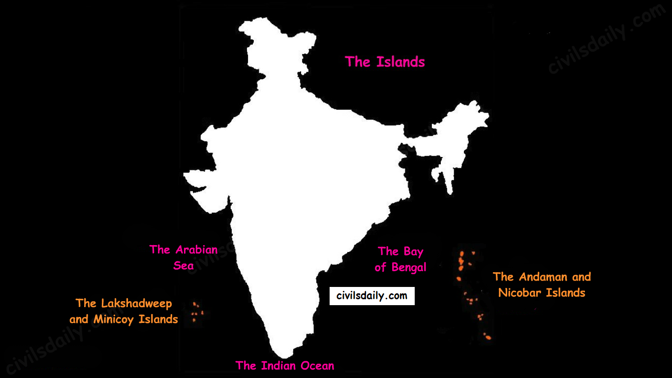
The Physiographic Divisions of India | The Islands Let’s take these up one by one:
Andaman & Nicobar Islands:
- Also called the emerald islands.
- Location and Extent:
- These are situated roughly between 6°N-14°N and 92°E -94°E.
- The most visible feature of the alignment of these islands is their narrow longitudinal extent.
- These islands extend from the Landfall Island in the north (in the Andamans) to the Indira Point (formerly known as Pygmalion Point and Parsons Point) in the south (In the Great Nicobar).
- Origin: The Andaman and Nicobar islands have a geological affinity with the tertiary formation of the Himalayas, and form a part of its southern loop continuing southward from the Arakan Yoma.
- The entire group of islands is divided into two broad categories:
- The Andaman in the north, and
- The Nicobar in the south.
They are separated by a water body which is called the Ten degree channel.
- The Andaman islands are further divided into:
- Great Andamans
- North Andaman
- Middle Andaman
- South Andaman
- Little Andaman
- Great Andamans
Little Andaman is separated from the Great Andamans by the Duncan Passage.
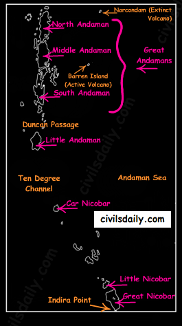
The Andaman and Nicobar Islands - Chief Characteristics:
- These are actually a continuation of Arakan Yoma mountain range of Myanmar and are therefore characterized by hill ranges and valleys along with the development of some coral islands.
- Some smaller islands are volcanic in origin e.g. the Barren island and the Narcondam Island. Narcondam is supposed to be a dormant volcano but Barren perhaps is still active.
- These islands make an arcuate curve, convex to the west.
- These islands are formed of granitic rocks.
- The coastal line has some coral deposits, and beautiful beaches.
- These islands receive convectional rainfall and have an equatorial type of vegetation.
- These islands have a warm tropical climate all year round with two monsoons.
- The Saddle peak (North Andaman – 738 m) is the highest peak of these islands.
- The Great Nicobar is the largest island in the Nicobar group and is the southernmost island. It is just 147 km away from the Sumatra island of Indonesia.
Lakshadweep Islands:
- These islands were earlier (before 1st November 1973) known as Laccadive, Minicoy and Amindivi Islands.
- Location:
- These are scattered in the Arabian Sea between 8°N-12°N and 71°E -74°E longitude.
- These islands are located at a distance of 280 km-480 km off the Kerala coast.
- Origin: The entire island group is built of coral deposits.
- Important islands:
- Amindivi and Cannanore islands in the north.
- Minicoy (lies to the south of the nine degree channel) is the largest island with an area of 453 sq. km.
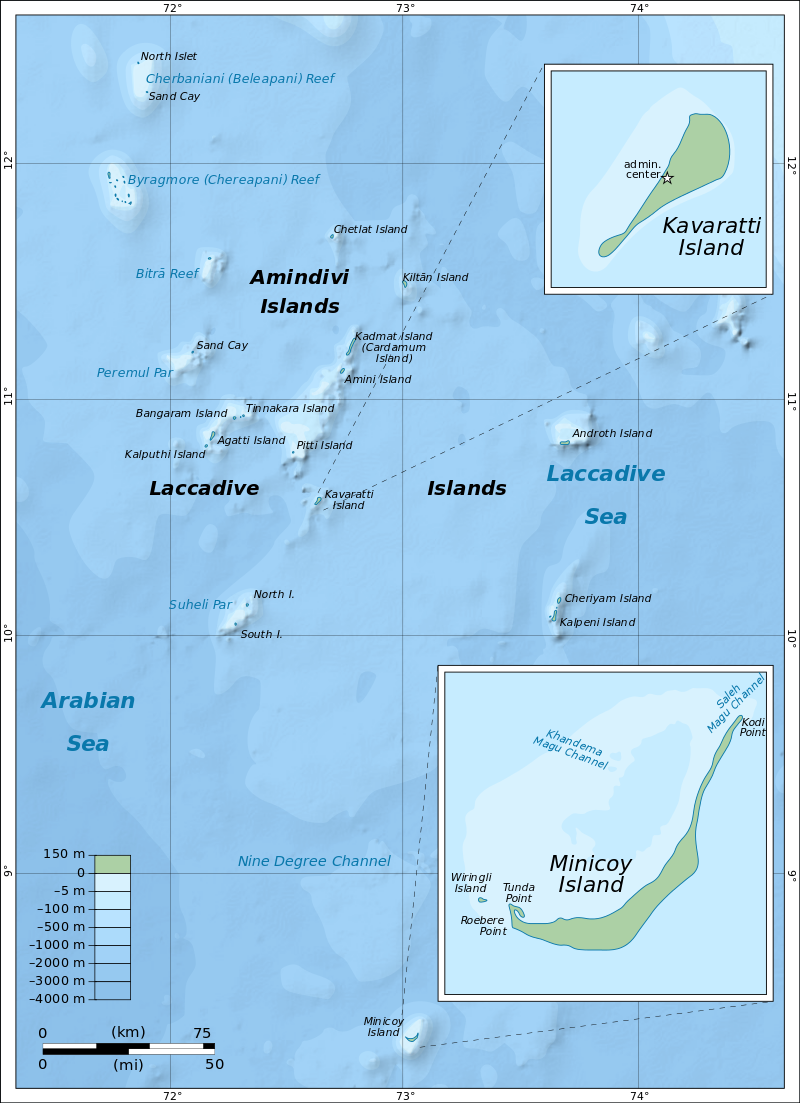
Source
- Chief Characteristics:
- These consist of approximately 36 islands of which 11 are inhabited.
- These islands, in general, have a north-south orientation (only Androth has an East-West orientation.
- These islands are never more that 5 metres above sea level.
- These islands have calcium rich soils- organic limestones and a scattered vegetation of palm species.
- One typical feature of these islands is the formation of crescentic reef in the east and a lagoon in the west.
- Their eastern seaboard is steeper.
- The Islands of this archipelago have storm beaches consisting of unconsolidated pebbles, shingles, cobbles and boulders on the eastern seaboard.
- The islands form the smallest Union Territory of India.
Other than the above mentioned two major groups, the important islands are:
- Majauli: in Assam. It is:
- The world’s largest freshwater (Brahmaputra river) island.
- India’s first island district
- Salsette: India’s most populous island. Mumbai city is located on this island.
- Sriharikota: A barrier island. On this island is located the satellite launching station of ISRO.
- Aliabet: India’s first off-shore oil well site (Gujarat); about 45 km from Bhavnagar, it is in the Gulf of Khambat.
- New Moore Island: in the Ganga delta. It is also known as Purbasha island. It is an island in the Sunderban deltaic region and it was a bone of contention between India and Bangladesh. In 2010, it was reported to have been completely submerged by the rising sea water due to Global warming.
- Pamban Island: lies between India and Sri Lanka.
- Abdul Kalam Island: The Wheeler Island near the Odisha coast was renamed as Abdul Kalam island in 2015. It is a missile launching station in the Bay of Bengal. The first successful land-to-land test of the Prithvi Missile was conducted from the mainland and it landed on the then uninhabited ‘Wheeler Island’ on November 30, 1993.
Now that we are done with this part, let’s try to attempt some questions from the past UPSC examinations:
Prelims:
1996
Question: ‘Saddle Peak’ the highest peak of Andaman and Nicobar islands is located in
A. Great Nicobar
B. Middle Andaman
C. Little Andaman
D. North Andaman
Ans. D
Mains:
Question: Write a short note on New Moore Island. (2006/2M)
Question: Write a short note on Indira Point. (2007/2M)
Question: Name the main physiographic divisions of India and give the salient features of each division. (2000/15M).
Question: How do the Andaman and Nicobar Islands and the Lakshadweep differ in the geological evolution and topographical conditions? (1998/15M)