Why in the News?
Union Defence Minister recently warned Pakistan against misadventure in the Sir Creek region, stressing India’s resolve to defend its territorial integrity.
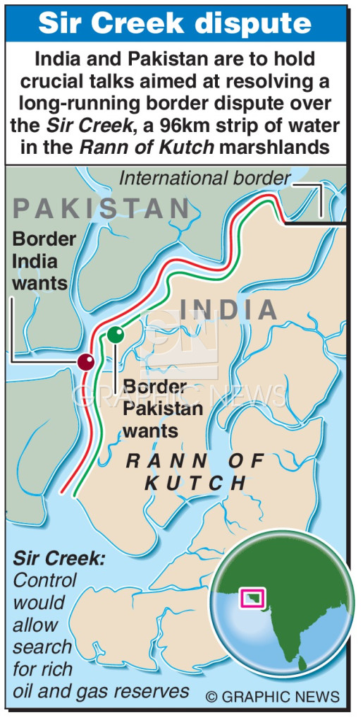
About Sir Creek:
- Location & Geography: Sir Creek is a 96-km-long tidal estuary in the Rann of Kutch, forming part of the border between Gujarat (India) and Sindh (Pakistan).
- Physical Features: It flows into the Arabian Sea, with marshy, saline mudflats that provide vital habitat for migratory birds.
- Historical Name: Originally known as Ban Ganga, renamed Sir Creek after a British surveyor, Sir Richard Burton (commonly credited).
- Economic & Strategic Importance: The area hosts rich fishing grounds and potential oil and gas deposits, while being crucial for maritime boundary delimitation and coastal security.
Historical Background of the Dispute:
- 1908 Conflict: Disagreement between the Kutch ruler (British India) and Sindh government over fishing rights and territorial limits.
- 1914 Bombay Government Resolution: Placed the boundary along the eastern bank (favouring Sindh/Pakistan), but also referred to the Thalweg Principle, supporting India’s claim.
- This principle defines the border along the line of greatest depth of a river’s main navigable channel
- 1924–25 Developments: Boundary pillars were erected and Survey of India maps marked the mid-channel as the boundary, strengthening India’s case.
- Post-Partition Period: Dispute intensified; following the 1965 India–Pakistan war, the Rann of Kutch issue went to a UN-sponsored Tribunal.
- 1968 Tribunal Award: Allocated 90% of the Rann to India but excluded Sir Creek, leaving it unresolved.
- Post-1982 UNCLOS Impact: With the introduction of Exclusive Economic Zones (EEZs), control over Sir Creek gained renewed importance for maritime claims and resource access.
India’s Position:
- Navigability Claim: India asserts that Sir Creek is navigable at high tide, making the Thalweg Principle applicable.
- Legal & Historical Basis:
- 1925 Resolution and Survey of India maps.
- Boundary pillars of 1924 marking mid-channel.
- 1819 Treaty between East India Company and Kutch rulers, showing continued Indian jurisdiction.
- Geographical Argument: India maintains the Rann is land, not water, invalidating Pakistan’s demand for median-line division.
- Strategic Implication: Acceptance of India’s position ensures larger EEZ access, security leverage, and greater control in the Arabian Sea.
| [UPSC 2022] Consider the following countries:
1. Azerbaijan 2. Kyrgyzstan 3. Tajikistan 4. Turkmenistan 5. Uzbekistan Which of the above have borders with Afghanistan ? Options: (a) 1, 2 and 5 only (b) 1, 2, 3 and 4 only (c) 3, 4 and 5 only* (d) 1, 2, 3, 4 and 5 |
Get an IAS/IPS ranker as your 1: 1 personal mentor for UPSC 2024