💥Join UPSC 2027,2028 Mentorship (August Batch) + XFactor Notes & Microthemes PDF

Subject: Climate Change

1. Global Warming and Issues
2. All about Pollution

  • Rising CO₂ Threatens Mangrove Fish Nurseries 

    Why in the News

    • A study in AGU Advances highlights declining oxygen levels in mangrove waters due to rising CO₂.

    Key Concept: Hypercapnic Hypoxia

    • Condition of: High CO₂ + Low dissolved oxygen
    • Occurs in: Mangrove estuaries (especially low tide, tropical regions)

    Major Findings

    • By 2100:
      • Oxygen ↓ 5–35%
      • CO₂ ↑ 8–60%
    • Events will:
      • Become 15× more frequent
      • Last longer (12–24 hours at 78% sites)

    Impact on Ecosystem

    1. Fish Nurseries at Risk

    • Reduced safe time for fish entry
    • Decline in juvenile fish survival

    2. Biodiversity Loss

    • Shift away from: Large reef-associated fish
    • Affects commercially important species

    3. Fisheries Impact

    • Mangroves: Support ~20,000 extra fish/ha/year
    • ~4 million fishers depend globally
    [2012] The acidification of oceans is increasing. Why is this phenomenon a cause of concern? The growth and survival of calcareous phytoplankton will be adversely affected. The growth and survival of coral reefs will be adversely affected. The survival of some animals that have phytoplanktonic larvae will be adversely affected. The cloud seeding and formation of clouds will be adversely affected. Select the correct answer using the code given below: (a) 1, 2 and 3 only (b) 2 only (c) 1 and 3 only (d) 1, 2, 3 and 4
  • [18th March 2026] The Hindu OpED: A bit of blur over India’s new carbon credit plan

    PYQ Relevance[UPSC 2025] What is Carbon Capture, Utilization and Storage (CCUS)? What is the potential role of CCUS in tackling climate change?Linkage: The PYQ covers climate change mitigation and environmental technology (GS 3), especially emission reduction strategies like CCUS. The article applies this through India’s CCUS-focused carbon credit policy, highlighting tension with agriculture-based carbon markets.

    Mentor’s Comment

    India’s Carbon Capture, Utilization, and Storage (CCUS) initiative aims to reduce greenhouse gas emissions to meet 2070 net-zero targets, focusing on high-emitting industrial sectors. The Union Budget 2026-27 announced a ₹20,000 crore scheme to scale up CCUS deployment, specifically targeting power, steel, cement, refineries, and chemical industries. The Budget 2026 announcement highlights the tension between industrial decarbonisation via CCUS and nature-based carbon markets involving agriculture. This raises issues of policy clarity, sectoral prioritisation, and climate governance design.

    What is the core objective of India’s carbon credit plan?

    1. Industrial Decarbonisation Focus: Targets sectors like power, steel, cement, refineries, and chemicals where emissions are concentrated and difficult to eliminate.
    2. CCUS Deployment: Ensures capture of CO₂ from industrial flue gases and its utilization or storage underground.
    3. Technology-led Transition: Supports R&D roadmap released by Department of Science and Technology (Dec 2025).
    4. Budgetary Commitment: ₹20,000 crore over five years for large-scale CCUS deployment.

    Why is agriculture excluded from CCUS strategy?

    1. Emission Characteristics: Agricultural emissions (methane, nitrous oxide) are diffuse and biologically mediated.
    2. Technological Limitation: CCUS is suited for point-source emissions, not dispersed sources like farms.
    3. Policy Segregation: Clear distinction between CCUS (industrial) and Carbon Dioxide Removal (CDR) via soil, biochar, agroforestry.
    4. Role of Agriculture: Positioned under carbon sequestration pathways, not industrial capture.

    What is causing confusion around ‘farmer carbon credits’?

    1. Terminology Overlap: Use of “carbon credit programme” creates perception of inclusivity across sectors.
    2. Parallel Narratives: Media and discourse suggest farmers can directly earn credits under Budget allocation.
    3. Existing Voluntary Markets: Agriculture and forestry projects already generate credits for domestic and global buyers.
    4. Policy Communication Gap: Lack of clear distinction between regulated compliance markets and voluntary carbon markets.

    What are the implications of prioritising CCUS over agriculture?

    1. Industrial Competitiveness: Supports decarbonisation of sectors contributing ~25% of India’s emissions.
    2. Net-Zero Alignment: Essential for achieving India’s climate commitments.
    3. Missed Rural Opportunity: Delays monetisation of agriculture’s carbon sequestration potential.
    4. Fiscal Prioritisation: Directs public funds toward capital-intensive technologies instead of nature-based solutions.

    Can agriculture-based carbon markets emerge as a parallel opportunity?

    1. Soil Carbon Sequestration: Enhances carbon storage through regenerative practices.
    2. Agroforestry Potential: Integrates trees into farming systems to generate carbon credits.
    3. Private Sector Initiatives: Pilot programmes compensate farmers for sustainable practices.
    4. Policy Requirement: Needs separate funding, institutional frameworks, and certification mechanisms.

    What policy approach is required to resolve the ambiguity?

    1. Clear Sectoral Demarcation: Separates ‘smokestack’ (industrial) and ‘soil’ (agriculture) carbon pathways.
    2. Dedicated Agricultural Policy: Establishes structured carbon farming programme with incentives.
    3. Market Development: Creates trusted domestic carbon market for agriculture credits.
    4. Communication Clarity: Ensures alignment between policy design and public narrative.

    Conclusion

    India’s carbon credit framework reflects a dual transition challenge: industrial decarbonisation through CCUS and agricultural transformation through carbon sequestration. Policy clarity, sector-specific instruments, and institutional coherence are essential to avoid misaligned expectations and unlock full climate and economic potential.

  • India Submits First National Report on Nagoya Protocol (ABS)

    Why in the News?

    India has submitted its First National Report (NR1) on the implementation of the Nagoya Protocol (ABS) to the Convention on Biological Diversity (CBD) on 27 February 2026, fulfilling obligations under Article 29.

    Key Highlights of the Report

    1. Reporting Period

    • Covers 1 November 2017 to 31 December 2025
    • Earlier Interim Report submitted in 2017

    2. Legal & Institutional Framework

    • Based on: Biological Diversity Act, 2002, Biological Diversity Rules, 2024 and ABS Regulations, 2025. 
    • Three-tier structure:
      • National Biodiversity Authority (NBA)
      • State Biodiversity Boards (SBBs) / UT Biodiversity Councils
      • Biodiversity Management Committees (BMCs)
    • 2,76,653 BMCs established → strong grassroots participation

    3. Access and Benefit Sharing (ABS) Performance

    • Total approvals (2017–2025): 12,830
      • NBA: 5,913 approvals (research, IPR, commercial use, etc.)
      • SBBs/UTBCs: 6,917 approvals (commercial utilization)

    4. Global Leadership in Compliance

    • 3,556 IRCCs (Internationally Recognised Certificates of Compliance) published
    • Accounts for over 60% of global total
    • Shows leadership in transparency under Nagoya Protocol

    5. Financial Benefits Generated

    • ₹216.31 crore mobilised through NBA approvals
      • ₹139.69 crore disbursed to: Local communities, Farmers, and Traditional knowledge holders
    • ₹51.96 crore generated via SBBs/UTBCs

    6. Non-Monetary Benefits

    • 395 approvals included: Capacity building, Technology transfer, Training and Collaborative research. 

    7. Monitoring of Foreign Biological Resources

    • 41 declarations received for use of foreign bioresources
    • Ensures compliance with international ABS norms

    8. Capacity Building & Awareness

    • 2,56,393 individuals trained
    • Through: 3,724 workshops and 600+ capacity-building initiatives

    9. Strategic Contribution

    • Supports Target 13 of India’s NBSAP (National Biodiversity Strategy and Action Plan)
    • Strengthens: Biodiversity conservation, Livelihood security, and Community participation
    [2025] Consider the following statements: 
    1. In India, the Biodiversity Management Committees are key to the realisation of the objectives of the Nagoya Protocol. 
    2. The Biodiversity Management Committees have important functions in determining access and benefit sharing, including the power to levy collection fees on the access of biological resources within its jurisdiction. 
    Which of the statements given above is/are correct? 
    (a) 1 only (b) 2 only (c) Both 1 and 2 (d) Neither 1 nor 2
  • ‘Super El Niño’ Alert: Risk of Record Global Heat

    Why in the News

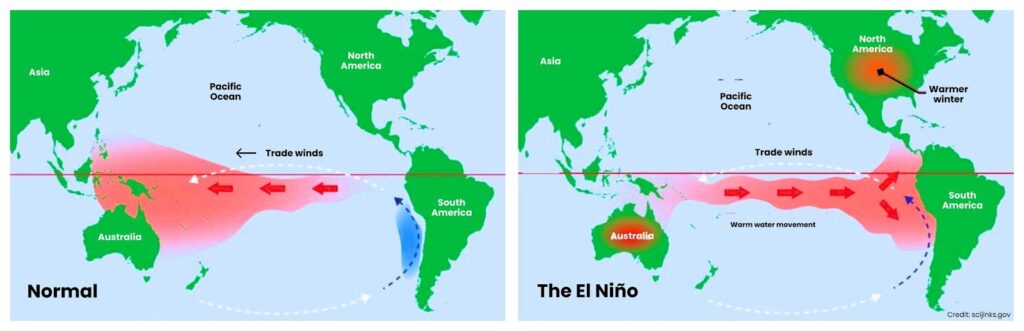
    Forecasters, including NOAA Climate Prediction Center, warn of a possible El Niño in 2026, with chances it could intensify into a “super El Niño”, potentially pushing global temperatures to new highs.

    What is El Niño?

    • A warm phase of the El Niño–Southern Oscillation (ENSO)
    • Occurs when Pacific Ocean surface waters become warmer than normal

    What is a “Super El Niño”?

    • When sea surface temperature rises ≥ 2°C above average
    • Much stronger than normal El Niño
    • Rare events: Last major one: 2015–16

    Current Situation

    • Present phase: La Niña (cool phase) is ending
    • Forecast: ~62% chance of El Niño by mid-2026 and ~15% chance of super El Niño

    How El Niño Works

    • Warm water shifts toward eastern Pacific
    • Weakens trade winds
    • Alters global weather systems
    [2011] La Niña is suspected to have caused recent floods in Australia. How is La Niña different from El Niño? 
    1. La Niña is characterized by unusually cold ocean temperature in the equatorial Indian Ocean whereas El Niño is characterized by unusually warm ocean temperature in the equatorial Pacific Ocean. 
    2. El Niño has an adverse effect on the southwest monsoon of India, but La Niña has no effect on monsoon climate. 
    Select the correct answer: 
    (a) 1 only (b) 2 only (c) Both 1 and 2 (d) Neither 1 nor 2
  • [16th March 2026] The Hindu OpED: Building India’s climate resilience with water at the core

    PYQ Relevance[UPSC 2017] Climate Change is a global problem. How India will be affected by climate change? How Himalayan and coastal states of India will be affected by climate change?Linkage: Climate change in India largely manifests through water stress, floods, glacial melt, and sea-level rise. The article links these impacts to Himalayan river instability and coastal aquifer salinisation, highlighting regional climate vulnerability.

    Why in the News?

    The COP30 Climate Summit in Belém (Brazil, 2025) introduced the first global adaptation indicators integrating Water, Sanitation and Hygiene (WASH) systems into climate accountability frameworks. Now there is a major shift in global climate governance: water systems are emerging as the central pillar of climate resilience. The outcomes of the UN Climate Conference COP30 and the Belém Adaptation Indicators place water management, sanitation, and hydrological governance at the core of adaptation strategies.

    How does climate change manifest primarily through water systems in India?

    1. Hydrological Disruptions: Climate change alters rainfall patterns, leading to extreme floods and prolonged droughts affecting urban and rural economies.
    2. Glacial Melt Impact: Himalayan glacier retreat destabilizes river systems, affecting long-term water availability for major rivers like the Ganga and Brahmaputra.
    3. Saline Intrusion: Rising sea levels cause salinisation of coastal aquifers, contaminating freshwater sources in coastal regions.
    4. Agricultural Vulnerability: Agriculture contributes ~40% of anthropogenic methane emissions, particularly from rice cultivation, livestock systems, and organic waste.
    5. Food Security Threats: Erratic monsoon cycles disrupt crop productivity and irrigation systems.

    What are Belém Adaptation Indicators?

    1. The Belém Adaptation Indicators are a set of 59-60 voluntary, global measures adopted at the COP30 climate summit in Belém, Brazil (scheduled for November 2025) to track how well countries are adapting to climate change. 
    2. Developed through a two-year UN process under the UAE-Belém Work Programme, they aim to provide a shared, practical language for monitoring resilience against climate impacts like floods, droughts, and heatwaves.

    Key Features of the Belém Adaptation Indicators are as follows:

    1. Purpose: To monitor progress toward the Global Goal on Adaptation (GGA) adopted under the Paris Agreement, focusing on whether communities are becoming safer and better able to cope with climate threats
    2. Focus Areas: The measures look at essential sectors such as water security, food systems, health, housing, early warning systems, ecosystems, and local economies
    3. Scope: The indicators emphasize protecting vulnerable populations, including women, indigenous groups, and people with disabilities
    4. Voluntary Nature: They are designed to be flexible rather than a rigid top-down mandate, allowing countries to adapt them to their national circumstances.

    How do Belém Adaptation Indicators redefine climate governance?

    1. Climate-Resilient Water Systems: Focus on reducing water scarcity and increasing resilience against floods and droughts.
    2. Universal Drinking Water Access: Ensures safe drinking water availability for all communities.
    3. Climate-Resilient Sanitation Infrastructure: Strengthens sanitation systems capable of functioning during extreme climate events.
    4. Multi-Hazard Early Warning Systems: Establishes universal early warning coverage by 2027.
    5. Hydrometeorological Capacity: Strengthens meteorological monitoring and national vulnerability assessments by 2030.

    How is India strengthening water governance to build climate resilience?

    1. Institutional Consolidation: Establishment of the Ministry of Jal Shakti (2019) integrates water governance across sectors.
    2. Water Vision 2047: Aligns national water policy with sustainability, equity, and climate resilience goals.
    3. Aquifer Mapping Programme: National Aquifer Mapping and Management Programme (NAQUIM 2.0) advances aquifer-level planning based on hydrogeological data.
    4. River Rejuvenation: National Mission for Clean Ganga (NMCG) expands focus beyond sewage treatment to biodiversity restoration and river basin management.
    5. Integrated Water Management: Encourages linking scientific hydrology with policy planning.

    What systemic risks threaten India’s climate-water resilience?

    1. Unequal Water Distribution: Water scarcity remains acute and unevenly distributed across regions.
    2. Water-Linked Disasters: Most climate disasters in India are water-related (floods, droughts, cyclones).
    3. Fragile Adaptation Finance: Global climate finance pathways remain uncertain despite projections of $1.3 trillion annually by 2035.
    4. Recovery Bias: Lack of predictable finance shifts focus toward post-disaster recovery rather than long-term resilience planning.
    5. Infrastructure Stress: Water supply systems require climate stress testing and diversification of water sources.

    Why is digital fragmentation a challenge for climate-water governance?

    1. Fragmented Data Systems: Hydrological and meteorological datasets remain distributed across institutions without integration.
    2. Limited AI-Driven Decision Support: Despite large datasets, real-time AI integration in governance remains weak.
    3. Planning Disconnect: Water data is rarely linked to budgeting, crop advisories, insurance mechanisms, or disaster response systems.
    4. Need for Interoperable Platforms: Integration of hydrological data, crop advisory systems, insurance frameworks, and financial flows is essential.

    How can India lead global climate adaptation through water governance?

    1. Policy Convergence: Align national missions such as drinking water coverage, irrigation efficiency, and urban water reforms with climate adaptation.
    2. Digital Public Infrastructure: Utilize India’s strength in digital governance systems to integrate climate-water datasets.
    3. Operational Adaptation: Shift from infrastructure creation to functional system resilience.
    4. Global South Leadership: Demonstrate scalable climate adaptation models applicable to other developing countries.

    Conclusion

    Water systems are emerging as the operational backbone of climate adaptation. India possesses strong institutional foundations, including water governance reforms, digital infrastructure, and river restoration programmes. However, translating policy ambition into measurable climate resilience requires integrating hydrological data, strengthening climate finance, and ensuring equitable water distribution. By aligning national missions with global adaptation frameworks, India can emerge as a leader in climate-resilient water governance for the Global South.

  • Ice patches on melting glaciers greater threat than thought: ISRO scientists

    Why in the News

    A new study by scientists from the Indian Space Research Organisation has identified exposed ice patches on retreating Himalayan glaciers as a key precursor to flash floods. The study examined the August 5, 2025 Dharali flash flood in Uttarakhand that killed nine people and devastated settlements along the Bhagirathi river valley. Satellite imagery revealed exposed ice patches in the nivation zone of the Srikanta glacier shortly before the disaster. (Nivation is defined as the erosion of the ground beneath and around a snow bank, primarily resulting from the processes of alternate freezing and thawing.) This indicates accelerated deglaciation and unstable cryosphere conditions. This finding marks an important shift in understanding Himalayan hazards: disasters may originate not only from glacial lake outburst floods (GLOFs) but also from smaller, previously overlooked cryospheric instabilities linked to warming temperatures.

    What are exposed ice patches?

    1. Exposed ice patches are areas of ancient, stable ice that have become visible on the surface of a glacier or mountain slope after their protective covering of seasonal snow and firn (intermediate ice) has thinned or melted away. 
    2. Unlike the main body of a glacier, which flows like a slow-moving river, these patches are often stationary and act as “prehistoric freezers”

    Reasons for their formation are as follows:

    1. Thinning Insulation: Warmer temperatures reduce the layers of snow and firn that normally insulate the deeper ice.
    2. Ablation: During the ablation period (when a glacier loses more ice/snow than it gains), these patches may emerge on steep, shaded slopes, particularly in nivation hollows where snow traditionally lingers year-round.
    3. Wind Scouring: In some regions, like Antarctica, strong winds can strip away top layers to reveal bright blue patches of older, denser ice.

    How do exposed ice patches signal accelerated glacier retreat in the Himalayas?

    1. Deglaciation indicator: Exposed ice patches in the Srikanta glacier’s ablation zone indicate thinning seasonal snow and firn cover due to rising temperatures.
    2. Satellite evidence: Pre-event satellite imagery showed persistent exposed ice patches on north-northeast facing slopes where snow normally accumulates.
    3. Cryosphere instability: Loss of insulating snow layers accelerates melting and structural weakening of glaciers.
    4. Regional warming effect: Similar processes have been documented in other warming cryosphere regions including the Canadian Arctic and Greenland.

    What role did nivation processes play in triggering the Dharali flash flood?

    1. Nivation process: Erosion of ground beneath snowbanks caused by alternate freezing and thawing cycles.
    2. Formation of nivation hollows: Repeated snow accumulation creates depressions which deepen over time.
    3. Structural instability: In steep Himalayan terrain, nivation hollows accumulate ice, meltwater, and debris.
    4. Trigger mechanism: Collapse of an exposed ice patch within the nivation zone of the Srikanta glacier released meltwater and debris.
    5. Result: Sudden downstream debris flow triggered the Dharali flash flood.

    Why are Himalayan glaciers increasingly vulnerable to cryosphere hazards?

    1. Rapid glacier retreat: Himalayan glaciers are losing ice due to rising regional temperatures.
    2. Snow and firn thinning: Seasonal snow cover that stabilizes glaciers is shrinking.
    3. Steep mountain terrain: High relief areas amplify instability and debris flow risks.
    4. Glacier fragmentation: Smaller unstable ice masses form as glaciers shrink.
    5. Emerging hazard types: Hazards now include not only GLOFs but also ice collapses, debris flows, and cryosphere mass movements.

    How do satellite observations improve early warning systems for glacier disasters?

    1. Pre-event detection: Satellite imagery identified exposed ice patches before the Dharali flood.
    2. Landscape monitoring: Remote sensing helps track glacier retreat and unstable cryosphere zones.
    3. Hazard reconstruction: Earth observation data reconstructs sequences leading to disasters.
    4. Early warning potential: Monitoring exposed ice patches could provide advance signals of possible cryosphere hazards.

    Why must disaster monitoring extend beyond glacial lakes to smaller cryosphere instabilities?

    1. Focus shift: Traditional monitoring emphasizes glacial lake outburst floods.
    2. Overlooked hazards: Small-scale cryosphere instabilities can trigger similar destructive floods.
    3. Regional prevalence: Similar geomorphological conditions exist across much of the Himalayan arc.
    4. Policy implication: Disaster risk assessment must include nivation zones and exposed ice patches.

    Conclusion

    Rapid glacier retreat in the Himalayas is generating new cryosphere hazards beyond traditional glacial lake outburst floods. The Dharali flash flood demonstrates how exposed ice patches and nivation-zone instability can trigger sudden disasters in high-mountain regions. Strengthening satellite monitoring, hazard mapping, and climate-resilient disaster management systems is essential to reduce risks and protect vulnerable Himalayan communities.

    PYQ Relevance

    [UPSC 2024] What is disaster resilience? How is it determined? Describe various elements of a resilience framework. Also mention the global targets of the Sendai Framework for Disaster Risk Reduction (2015-2030).

    Linkage: The Dharali flash flood from glacier ice-patch collapse highlights the need for disaster resilience in fragile Himalayan regions facing climate-induced hazards. It underlines the importance of Sendai Framework goals like risk monitoring, early warning systems, and satellite-based glacier surveillance.

  • Behind an early summer is a lack of winter rains

    Why in the News?

    An unusual surge in temperatures across north and north-western India during February-March has raised concerns about shifting seasonal patterns. Several regions recorded temperatures 8-13°C above normal, bringing heat-wave-like conditions weeks before the usual onset of summer. The phenomenon has been linked to deficient winter rainfall and weak Western Disturbances, which are critical for regulating winter climate in north India. 

    Why is India witnessing unusually high temperatures early this year?

    1. Temperature Anomaly: Several regions recorded temperatures 8-13°C above normal, reaching heat-wave-like conditions in February-March.
    2. Early Heat Conditions: Warm weather replaced cool winter days earlier than usual in northern and western India.
    3. Rare Occurrence: A similar situation occurred three years ago, but such an early onset of summer remains relatively uncommon.
    4. Regional Evidence:
      1. Shimla: 25.3°C (March 2026, highest recorded till March 8).
      2. Pahalgam: 22.7°C.
      3. Gulmarg: 17.2°C.
      4. Srinagar: 24.7°C.

    Climatological Significance: Heat waves are generally uncommon in high-altitude regions such as Shimla in March.

    How did weak Western Disturbances influence the winter climate?

    1. Western Disturbances: East-moving rain-bearing weather systems originating beyond Iran and drawing moisture from the Mediterranean Sea and other water bodies.
    2. Seasonal Importance: These systems normally bring winter rainfall and snowfall across northern India.
    3. Deficiency Since November 2025: Reduced frequency and intensity of Western Disturbances led to lower winter precipitation.
    4. IMD Observation: Meteorologists noted lack of wind convergence between westerly and easterly winds, reducing moisture transport into north and central India.
    5. Temperature Regulation: Winter precipitation normally moderates temperatures by maintaining soil moisture and atmospheric cooling.

    Why was the winter of 2026 considered unusually dry?

    1. Rainfall Deficit: All-India rainfall during January-February was only 16 mm, which is 60% below normal.
    2. Historical Context: February 2026 became the third driest February since 1901.
    3. Snowfall Decline: Both snowfall and rainfall remained subdued across Himalayan regions.
    4. Meteorological Cause: Persistent lack of favourable weather systems during winter months.

    How does a dry winter accelerate the onset of summer?

    1. Soil Moisture Deficit: Reduced rainfall leaves soil dry and unable to moderate temperature increases.
    2. Evaporation Mechanism: Moist soils normally evaporate moisture before heating up, delaying temperature rise.
    3. Rapid Surface Heating: Dry soils heat faster, increasing land surface temperature and accelerating summer conditions.
    4. Climate Feedback: Dry land conditions amplify regional warming and heat stress.

    What are the implications for agriculture and water resources?

    1. Impact on Rabi Crops: Sudden temperature spikes affect mustard, wheat, gram, groundnut, sesame, sorghum, and sunflower.
    2. Horticulture Stress: Crops such as potatoes and apples may suffer due to heat stress.
    3. Irrigation Demand: Farmers have been advised to increase irrigation frequency to maintain soil moisture.
    4. Water Resource Pressure: Increased irrigation demand may strain local groundwater and water reserves.

    What do temperature records indicate about changing climatic patterns?

    1. Temperature Extremes: High temperatures in Himalayan regions during early March indicate increasing climate variability.
    2. Comparison with Past Years:
      1. 2026: Shimla 25.3°C, Pahalgam 22.7°C, Gulmarg 17.2°C, Srinagar 24.7°C.
      2. 2025: Shimla 24.4°C, Pahalgam 20.4°C.
      3. 2024: Shimla 24.8°C.
    3. Climate Signal: Frequent anomalies suggest greater unpredictability in seasonal transitions.

    Conclusion

    The early onset of summer in India highlights the critical role of winter rainfall and Western Disturbances in maintaining seasonal balance. Reduced precipitation has accelerated land heating and increased agricultural vulnerability. Strengthening climate monitoring, improving irrigation management, and integrating seasonal forecasting into agricultural planning are essential to mitigate the impacts of such climatic anomalies.

    PYQ Relevance

    [UPSC 2017] Climate Change’ is a global problem. How will India be affected by climate change? How will Himalayan and coastal states of India be affected?

    Linkage: The early onset of summer due to weak winter rains and Western Disturbances reflects climate variability affecting Himalayan regions, highlighting changing temperature and precipitation patterns.

  • 204 of 238 Indian Cities Failed to Meet Air Quality Standards

    Why in the News

    A report by the Centre for Research on Energy and Clean Air (CREA) analysing Central Pollution Control Board (CPCB) data found that 204 out of 238 Indian cities exceeded national air quality standards during winter 2025–26.

    Centre for Research on Energy and Clean Air (CREA)Centre for Research on Energy and Clean Air (CREA) is an independent international research organisation that focuses on energy, air pollution, and climate change analysis. It is widely cited in global media and policy discussions for its data-driven assessments of fossil fuel use, emissions, and air quality impacts.

    Key Findings of the Report

    • Most Polluted Cities
      • Top cities with the highest PM2.5 concentration: Ghaziabad – 172 µg/m³, Noida – 166 µg/m³, and Delhi – 163 µg/m³
      • Other highly polluted cities include: Greater Noida, Bahadurgarh, Dharuhera, Gurugram, Bhiwadi, Charkhi Dadri, and Baghpat.
      • Most cities in the top 10 are from Uttar Pradesh and Haryana.
    • Megacity Air Pollution Levels
    • Average PM2.5 concentrations in major Indian cities:
      • Delhi – 163 µg/m³
      • Kolkata – 78 µg/m³
      • Mumbai – 48 µg/m³
      • Chennai – 44 µg/m³
      • Bengaluru – 39 µg/m³ (slightly below national limit)
    • Cleanest City
      • The cleanest city recorded was: Chamarajanagar – 19 µg/m³
      • Eight of the ten cleanest cities were in Karnataka, with one each in Madhya Pradesh and Meghalaya.

    PM2.5 Explained

    PM2.5 (Particulate Matter ≤2.5 micrometers)

    • Extremely fine particles in the air.
    • Can enter lungs and bloodstream.
    • Causes: Respiratory diseases, Heart disease, and Premature deaths.

    Prelims Pointers

    • CPCB functions under the Ministry of Environment, Forest and Climate Change.
    • National Ambient Air Quality Standards (NAAQS) specify permissible pollutant levels in India.
    • PM2.5 is considered one of the most dangerous air pollutants due to its ability to penetrate deep into the respiratory system.
    [2022] In the context of WHO Air Quality Guidelines, consider the following statements: The 24-hour mean of PM2.5 should not exceed 15 µg/m³ and annual mean of PM2.5 should not exceed 5 µg/m³. In a year, the highest levels of ozone pollution occur during the periods of inclement weather. PM10 can penetrate the lung barrier and enter the bloodstream. Excessive ozone in the air can trigger asthma. Which of the statements given above are correct? (a) 1, 3 and 4 (b) 1 and 4 only (c) 2, 3 and 4 (d) 1 and 2 only
  • [5th March 2026] The Hindu OpED: Climate risks must prompt international legal reforms

    PYQ Relevance
    [UPSC 2017] ‘Climate Change’ is a global problem. How will India be affected by climate change? How will Himalayan and coastal states of India be affected by climate change?Linkage: This question relates directly to the article’s discussion on sea-level rise, climate displacement, and governance challenges. It highlights the global and regional impacts of climate change, which underpin debates on international legal frameworks and climate justice.

    Mentor’s Comment

    Rising sea levels and climate-induced migration are exposing major gaps in international law, particularly regarding statehood, refugee protection, and maritime boundaries. Vulnerable small island states and forums like the Pacific Islands Forum (2023) have raised concerns that existing frameworks such as the Montevideo Convention, UNCLOS, and the 1951 Refugee Convention do not adequately address climate-driven territorial loss and displacement, prompting calls for international legal reforms.

    What is Permanent Sovereignty over Natural Resources (PSNR)?

    1. Concept: Permanent Sovereignty over Natural Resources (PSNR) is a principle of international law that affirms the sovereign right of states and peoples to control, use, and exploit natural resources within their territory in accordance with national development priorities.
    2. Legal Origin: The principle was formally articulated in UN General Assembly Resolution 1803 (1962) on Permanent Sovereignty over Natural Resources, adopted during the decolonisation period.
    3. Core Objective: Ensures that newly independent and developing countries retain control over their natural resources, preventing external exploitation by foreign powers or multinational corporations.
    4. Developmental Dimension: Recognises that control over resources such as minerals, fossil fuels, forests, and water is essential for economic growth, industrialisation, and poverty reduction.
    5. State Authority: Grants governments the right to regulate extraction, nationalise resources, and determine terms of foreign investment in the resource sector.
    6. Climate Governance Tension: Global climate goals requiring phasing out fossil fuels create tensions with PSNR, as states traditionally retain the sovereign right to exploit hydrocarbons within their territory.
    7. Relevance to Climate Debate: The emerging idea of a Fossil Fuel Non-Proliferation Treaty and discussions at COP28 and COP30 raise questions about whether global climate obligations can limit a state’s sovereign control over fossil resources.

    How does climate change challenge the principle of Permanent Sovereignty over Natural Resources (PSNR)?

    1. Permanent Sovereignty over Natural Resources (PSNR): Developing countries rely on PSNR to extract fossil fuels above and below ground.
    2. Developmental Imperative: Enables developing states to pursue economic independence and development through resource exploitation.
    3. Climate Mitigation Pressure: Global efforts to limit warming to 1.5°C require reducing fossil fuel extraction, creating tension with PSNR.
    4. Fossil Fuel Non-Proliferation Treaty Proposal: Suggests keeping large portions of fossil fuels unexploited to limit emissions.
    5. COP Negotiations: Discussions at COP28 (Conference of the Parties to the UNFCCC, Dubai 2023) and COP30 (Belém, Brazil 2025) indicate growing momentum toward phasing out fossil fuels, even outside formal negotiation agendas.
    6. Equity Debate: Developing countries may accept limited obligations only if developed nations provide finance and transfer carbon-neutral technologies.

    How does sea-level rise threaten the concept of statehood under international law?

    1. Montevideo Convention (1933): Defines statehood through four criteria, territory, permanent population, government, and capacity to enter relations with other states.
    2. Territorial Requirement: Statehood traditionally requires a defined territory.
    3. Sea Level Rise (SLR): Rising oceans threaten to submerge low-lying island states, raising questions about whether a state can continue to exist without territory.
    4. State Continuity Doctrine: Customary international law generally presumes that once established, statehood continues despite territorial loss.
    5. International Court of Justice Advisory Opinion: Suggests disappearance of one element of statehood does not automatically end statehood.
    6. Pacific Islands Forum (2023): Declared that international law does not yet address the extinction of states due to climate change.
    7. Legal Ambiguity: Scholars note that no minimum territorial threshold exists for statehood, leaving the issue unresolved.

    How does climate change create gaps in international refugee protection?

    1. 1951 Refugee Convention: Defines refugees as persons fleeing persecution based on race, religion, nationality, social group, or political opinion.
    2. Legal Gap: Climate-displaced persons do not fall within this definition.
    3. Climate Migration: Sea-level rise and environmental degradation are expected to cause large-scale cross-border displacement.
    4. Loss of Rights: Climate migrants may lose protections and benefits linked to citizenship in their home country.
    5. Proposal for New Protocol: Suggests creating a separate legal regime under the UNFCCC to recognise and protect climate refugees.
    6. Institutional Support: A protocol under the UNFCCC could build on political commitments from the Paris Agreement and COP negotiations.

    How could sea-level rise unsettle maritime zones and ocean governance?

    1. Baseline Concept: The baseline represents the legal starting point for measuring maritime zones under international law.
    2. UNCLOS Maritime Zones: Baselines determine territorial sea, contiguous zone, Exclusive Economic Zone (EEZ), and continental shelf.
    3. Shifting Coastlines: Rising sea levels may alter baselines, potentially changing maritime boundaries.
    4. Strategic Implications: Changes in baselines may affect control over marine resources, fisheries, and seabed minerals.
    5. Pacific Island States Initiative: Some states propose declaring existing baselines as permanent to prevent loss of maritime zones.
    6. Ambulatory Baseline Approach: UNCLOS traditionally allows baselines to shift with coastline changes.
    7. Interpretation Challenge: Accepting either approach would require reinterpretation or amendment of UNCLOS provisions.

    Why must international legal frameworks adapt to climate risks?

    1. Institutional Gap: Existing international law was designed without anticipating climate-induced territorial and demographic disruptions.
    2. Systemic Risk: Climate change now affects statehood, migration, sovereignty, and maritime governance simultaneously.
    3. UNFCCC Platform: Provides a global forum through Conference of Parties (COP) to discuss legal adaptation.
    4. Equitable Governance: Legal reforms must incorporate equity, responsibility sharing, and technological support.
    5. Global Stability: Updating legal frameworks ensures predictability and protection for vulnerable states and populations.

    Conclusion

    Climate change is increasingly exposing structural gaps in international law related to statehood, sovereignty, migration, and maritime governance. Addressing these challenges requires adaptive legal frameworks, equitable climate cooperation, and stronger multilateral coordination to protect vulnerable states and ensure stability in the evolving global order.

  • Why carbon capture is key to achieving net-zero goal

    Why in the News?

    The Union Budget has, for the first time, made a large, dedicated fiscal commitment of ₹20,000 crore to carbon capture, utilisation and storage. This marks a shift from pilot-driven experimentation to scale-oriented deployment. The urgency is underscored by global data showing 1 billion tonnes of annual CO₂ capture required by 2030, while only 50 million tonnes are currently captured worldwide. India’s net-zero pathway increasingly depends on CCUS as emissions from cement, steel and chemicals cannot be eliminated through renewable energy substitution alone.

    What is Carbon Capture, Utilisation and Storage?

    1. It refers to technologies that capture CO₂ from industrial processes, transport it, and either store it in geological formations or convert it into useful products.
    2. Process Stages: CCUS involves capturing carbon dioxide (via post-combustion, pre-combustion, or oxy-fuel combustion), transporting it, and either using it for industrial applications or storing it permanently
    3. Role in Climate Change: It is essential for decarbonizing “hard-to-abate” sectors, including steel, cement, and chemical production, which account for significant global emissions.
    4. Carbon Removal: CCUS enables negative emissions through technologies like Bioenergy with Carbon Capture and Storage (BECCS) and Direct Air Capture (DACCS).
    5. Challenges: High capital costs, energy intensity (high auxiliary power consumption), safety concerns, and infrastructure needs for transport are major bottlenecks.

    What Does Carbon Capture, Utilisation and Storage Involve?

    1. Carbon Capture: Enables separation of CO₂ from industrial exhaust streams in cement, steel, power and refining operations.
    2. Carbon Storage: Facilitates long-term containment of CO₂ in geological formations such as depleted oil and gas reservoirs.
    3. Carbon Utilisation: Supports conversion of captured CO₂ into chemicals and industrial inputs, reducing fresh fossil use.

    Why Is CCUS Critical for Achieving Net-Zero?

    1. Hard-to-Abate Emissions: Addresses emissions that arise from chemical reactions in cement and steel, not from fuel combustion.
    2. Limits of Renewables: Recognises that shifting to renewable electricity does not eliminate process emissions in heavy industry.
    3. Climate Mitigation: Enables deep emissions reduction without compromising industrial output and economic growth.

    What Is the Current Global Status of Carbon Capture?

    1. Operational Capacity: Includes 45 commercial CCUS facilities worldwide.
    2. Captured Volume: Accounts for only 50 million tonnes of CO₂ annually, far below climate targets.
    3. 2030 Requirement: Indicates a need for 1 billion tonnes of CO₂ capture per year by 2030 to align with net-zero pathways.
    4. Deployment Gap: Highlights a sharp mismatch between climate targets and present technological scale.

    What Is the Status of CCUS Technologies in India?

    1. Pilot Projects: Includes initiatives by Tata Steel, Dalmia Cement, NTPC, ONGC, focusing on capture feasibility.
    2. Research Ecosystem: Involves dozens of research groups working on capture materials and processes.
    3. Institutional Leadership: Anchored by Centres of Excellence at Indian Institute of Technology Bombay and Jawaharlal Nehru Centre for Advanced Scientific Research, focusing on indigenous CCUS solutions.
    4. Readiness Gap: Indicates laboratory-level maturity but limited field-scale testing.

    How Does the Union Budget Change the CCUS Landscape?

    1. Fiscal Allocation: Provides ₹20,000 crore for CCUS technology development and deployment.
    2. Scale Transition: Signals movement from pilot projects to industrial demonstration.
    3. Cost Reduction: Aims to address high capital and operational costs that restrict commercial viability.
    4. Industrial Adoption: Targets steel, cement, refineries and chemicals as early adopters.

    Why Are Certain Industries Central to CCUS Deployment?

    1. Cement Sector: Generates CO₂ as an inherent by-product of limestone calcination.
    2. Steel Sector: Emits carbon through coke-based reduction processes.
    3. Chemical and Refining Industries: Produce process emissions independent of energy source.
    4. Competitiveness: Aligns emission reduction with global trade requirements, including carbon border measures.

    What Are the Economic and Strategic Benefits of CCUS?

    1. Industrial Continuity: Enables emission reduction without relocating or shutting down core industries.
    2. Global Competitiveness: Reduces exposure to mechanisms such as the EU’s Carbon Border Adjustment Mechanism.
    3. Technology Leadership: Positions India as a developer, not just adopter, of CCUS technologies.
    4. Cost Containment: Prevents loss of competitiveness from carbon-intensive exports.

    Conclusion

    CCUS is not a substitute for renewable energy but a necessary complement for India’s net-zero strategy. The Budget’s ₹20,000 crore allocation marks a decisive shift from experimentation to scale. However, success depends on rapid field deployment, cost reduction, and industry integration to ensure CCUS delivers measurable emissions reduction by 2030.

    PYQ Relevance

    [UPSC 2025] What is Carbon Capture, Utilization and Storage (CCUS)? What is the potential role of CCUS in tackling climate change? 

    Linkage: This question is directly linked to GS III (Environment, Climate Change, Clean Technologies), reflecting UPSC’s focus on technological pathways for achieving net-zero and decarbonising hard-to-abate industries.