💥Join UPSC 2027,2028 Mentorship (July Batch) + XFactor Notes & Microthemes PDF

Subject: Conservation & Mitigation

1. Conservation Progs.
2. Worldwide initiatives
3. Mitigation Strategies
4. Conventions and Protocols

  • Jadav Payeng: The Forest Man of India

    Jadav Payeng, known as ‘The Forest Man of India’, takes us through his journey of grit that saw a desert turning into a forest. His story is been depicted through an upcoming trilingual film.

    We knew about the mountain man in India. We have also had the Forest Man of India who is also a living inspiration for successful afforestation. We can quote such examples in essays very well.

    Who is Jadav Payeng?

    • Jadav “Molai” Payeng (born 1963) is an environmental activist and forestry worker from Majuli Island popularly known as the Forest Man of India.
    • He was born in the indigenous Mising tribe of Assam.
    • Over the course of several decades, he has planted and tended trees on a sandbar of the river Brahmaputra turning it into a forest reserve.
    • The forest, called Molai forest after him is located near Kokilamukh of Jorhat, Assam, India and encompasses an area of about 1,360 acres / 550 hectares.
    • In 2015, he was honoured with Padmashri, the fourth highest civilian award in India.

    His work

    • The forest, which came to be known as Molai forest, now houses Bengal tigers, Indian rhinoceros, and over 100 deer and rabbits.
    • Molai forest is also home to elephants and several varieties of birds, including a large number of vultures.
    • Bamboo covers an area of over 300 hectares.
  • World Heritage Irrigation Structure (WHIS) Sites

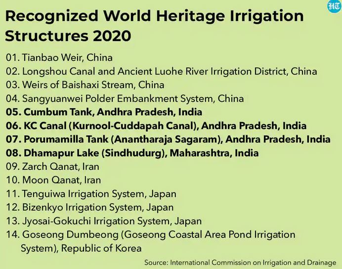
    Four sites in India have received the World Heritage Irrigation Structure (WHIS) tag this year.

    Try this PYQ:

    Q.The FAO accords the status of ‘Globally Important Agricultural Heritage Systems (GIAHS)’ to traditional agricultural systems. What is the overall goal of this initiative?

    1. To provide modern technology, training in modern farming methods and financial support to local communities of identified GIAHS so as to greatly enhance their agricultural productivity.
    2. To identify and safeguard eco-friendly traditional farm practices and their associated landscapes, agricultural biodiversity and knowledge systems of the local communities.
    3. To provide Geographical Indication status to all the varieties of agricultural produce in such identified GIAHS.

    Select the correct answer using the code given below:

    (a) 1 and 3 only

    (b) 2 only

    (c) 2 and 3 only

    (d) 1, 2 and 3

    World Heritage Irrigation Structure (WHIS)

    • The International Commission on Irrigation and Drainage (ICID) annually recognizes irrigation structures of international significance like UNESCO’s World Heritage Sites.
    • The recognition is aimed at recognizing and tracing the history of and understanding the evolution of irrigation in civilizations across the world.
    • It also aims at understanding the philosophy and wisdom on sustainable irrigation from these structures and to preserve them for posterity.

    Criteria for consideration

    • Major criteria for WHIS entail that a structure should be more than 100 years old, should be functional, achieving food security and have archival value.
    • Each site is evaluated based on its merits first by the state government.
    • The proposal is then sent to the Centre and a team from CWC carries out an on-ground survey to verify details.

    Which are the Indian sites?

    • The sites are Cumbum Tank, Kurnool-Cuddapah Canal, Porumamilla Tank (Anantharaja Sagaram) in Andhra Pradesh and 490-year-old Dhamapur Lake in Maharashtra’s Sindhudurg district.
    • In 2018, Pedda Cheru Tank in Kamareddy district and Sadarmat Anicut in Nirmal district, both in Telangana, were named as WHIS sites.

    Other sites

    • The rest include Tianbao Weir in China at number one followed by Longshou Canal and ancient Luohe river irrigation district, China.
    • It also includes Zarch and Moon Qanat both in Iran and Tenguiwa, Bizenkyo and Jyosai Gokuchi irrigation systems in Japan with Goseong Dumbeong in the Republic of Korea.

    About ICID

    • The ICID, established in 1950 is a leading scientific, technical, international not-for-profit, non-governmental organization.
    • It is a professional network of experts from across the world in the field of irrigation, drainage, and flood management.
    • The main mission is to promote ‘Sustainable agriculture water management’ to achieve ‘Water secure world free of poverty and hunger through sustainable rural development’.
    • ICID mission covers the entire spectrum of agricultural water management practices ranging from rainfed agriculture to supplemental irrigation, land drainage, deficit irrigation to full irrigation, etc.
  • Peatlands and their importance

    Sustainably managing peatlands — peat-swamp forests found around the tropics — can protect humans from future pandemics, according to a new study.

    What are Peatlands?

    • Peatlands are terrestrial wetland ecosystems in which waterlogged conditions prevent plant material from fully decomposing.
    • Consequently, the production of organic matter exceeds its decomposition, which results in a net accumulation of peat.
    • Over millennia this material builds up and becomes several metres thick.
    • They occur in almost every country on Earth, currently covering 3% of the global land surface.
    • Peatland landscapes are varied – from blanket bog landscapes with open, treeless vegetation in the Flow Country of Scotland – a tentative World Heritage site – to swamp forests in Southeast Asia.

    Their importance

    • Peatlands are the largest natural terrestrial carbon store. This area sequesters 0.37 gigatonnes of CO2 a year.
    • In their natural, wet state peatlands provide vital ecosystem services.
    • By regulating water flows, they help minimise the risk of flooding and drought and prevent seawater intrusion.
    • In many parts of the world, peatlands supply food, fibre and other local products that sustain local economies.
    • They also preserve important ecological and archaeological information such as pollen records and human artefacts.

    Try this PYQ now:

    In the context of mitigating the impending global warming due to anthropogenic emission of carbon dioxide, which of the following can be the potential sites for carbon sequestration?

    1. Abandoned and Uneconomic coal seams
    2. Depleted oil and gas reservoirs
    3. Subterranean deep saline formations

    Select the correct answer using the code given below:

    (a) 1 and 2 only

    (b) 1 and 3 only

    (c) 3 only

    (d) 1, 2 and 3

    Why conserve peatlands?

    • The protection and restoration of peatlands are vital in the transition towards a low-carbon and circular economy.
    • Damaged peatlands contribute about 10% of greenhouse gas emissions from the land-use sector.
    • CO2 emissions from drained peatlands are estimated at 1.3 gigatonnes of CO2 annually.
    • This is equivalent to 5.6% of global anthropogenic CO2 emissions.
    • Draining peatlands reduces the quality of drinking water due to pollution from dissolved compounds.

    What is the new study?

    • Peatlands were rich in biodiversity, including many potential vertebrate and invertebrate vectors, or carriers of disease, the study said.
    • These included numerous vertebrates known to represent a risk of spreading zoonotic diseases, such as bats, rodents, pangolins and primates.
    • These areas also faced high levels of habitat disruption such as wild or human-made fires and wildlife harvesting that was perfect conditions for potential emerging zoonotic diseases.
    • The first reported case of Ebola in 1976 was from a peatland area.
    • The cradle of the HIV/AIDS pandemic was believed to be around Kinshasa in the Democratic Republic of the Congo, another area with extensive peatlands.
  • What are Miyawaki Forests?

    Japan-inspired Miyawaki forests are emerging as a popular solution to restoring degraded habitats in the country.

    Try this question:

    Q.The Miyawaki Forests technique has to potential to revolutionize the concept of urban afforestation in India. Discuss.

    Miyawaki Forests

    • Doctor Akira Miyawaki, botanist and professor, is the inventor of the technique since 1980.
    • He is a recipient of the 2006 Blue Planet Prize, which is the equivalent of a Nobel Prize in ecology.
    • The approach is supposed to ensure that plant growth is 10 times faster and the resulting plantation is 30 times denser than usual.
    • It involves planting dozens of native species in the same area and becomes maintenance-free after the first three years.

    The technique

    • The method takes its inspiration directly from processes and diversity in nature: 15 to 30 different species of trees and shrubs are planted together.
    • This plant community works very well together and is perfectly adapted to local weather conditions.
    • The habitat thus created will get more complex over time and attract much biodiversity.
    • Vegetation becomes much denser than conventional plantations, and it has the structure of a mature natural forest. It is a multi-storey structure, where different levels of vegetation appear.
    • The forest thus structured delivers many benefits in the form of ecosystem services.
    • It would take about 200 years to let a forest recover on its own. With the Miyawaki method, a similar result is achieved in 20 years.
  • Understanding the interplay between subsidies and agri-pollution

    Agriculture’s contribution to air pollution

    • Agriculture’s contribution to air pollution runs deeper than what happens between crop seasons.
    • The Indo-Gangetic plain is also one of the world’s largest and rapidly-growing ammonia hotspots.
    • Atmospheric ammonia, which comes from fertiliser use, animal husbandry, and other agricultural practices, combines with emissions from power plants, transportation and other fossil-fuel burning to form fine particles.

    Impact of pollution on agriculture

    • It is important to note that agriculture is a victim of pollution as well as its perpetrator.
    • Particulate matter and ground-level ozone formed from industrial, power plant, and transportation emissions among other ingredients cause double-digit losses in crop yields.
    • Ozone damages plant cells, handicapping photosynthesis, while particulate matter dims the sunlight that reaches crops.
    • Agriculture scientist Tony Fischer’s 2019 estimates of the two pollutants’ combined effect suggest that as much as 30 per cent of India’s wheat yield is missing (Sage Journals, Outlook on Agriculture).
    • Earlier, B Sinha et al (2015), in Atmospheric Chemistry and Physics Discussions, found that high ozone levels in parts of Haryana and Punjab could diminish rice yields by a quarter and cotton by half.

    Role played by subsidies

    • The current system of subsidies is a big reason that there is stubble on these fields in the first place.
    • Free power — and consequently, “free” water, pumped from the ground — is a big part of what makes growing rice in these areas attractive.
    • Open-ended procurement of paddy, despite the bulging stocks of grains with the Food Corporation of India, adds to the incentives.
    • Subsidies account for almost 15 per cent of the value of rice being produced in Punjab-Haryana belt.
    • Fertiliser, particularly urea in granular form, is highly subsidised.
    • It is one of the cheapest forms of nitrogen-based fertiliser, easy to store and easy to transport, but it is also one of the first to “volatilise,” or release ammonia into the air.
    • This loss of nitrogen then leads to a cycle of more and more fertiliser being applied to get the intended benefits for crops.

    Way forward

    • We need to shift the nature of support to farmers from input subsidies to investment subsidies.
    • This could involve the conversion of paddy areas in this belt to orchards with drip irrigation, vegetables, corn, cotton, pulses and oilseeds.
    • All of the above consume much less water, much less power and fertilisers and don’t create stubble to burn.
    • A diversification package of, say, Rs 10,000 crore spread over the next five years, equally contributed by the Centre and states, may be the best way to move forward in reducing agriculture-related pollution.
    • The approach to diversification has to be demand-led, with a holistic framework of the value chain, from farm to fork and not just focused on production.
    • On the fertiliser front, it would be better to give farmers input subsidy in cash on per hectare basis, and free up the prices of fertilisers completely.

    Conclusion

    Taken together, these measures could double farmers’ incomes, promote efficiency in resource use, and reduce pollution — a win-win solution for all.

  • India’s Deep Ocean Mission

    India will soon launch an ambitious ‘Deep Ocean Mission’ that envisages exploration of minerals, energy and marine diversity of the underwater world, a vast part of which still remains unexplored.

    Deep Ocean Mission (DOM)

    Nodal Agency: Ministry of Earth Sciences (MoES)

    • The mission proposes to explore the deep ocean similar to the space exploration started by ISRO.
    • Underwater robotics and ‘manned’ submersibles are key components of the Mission which will help India harness various living and non-living (water, mineral and energy) resources from the seabed and deep water.
    • The tasks that will be undertaken over this period include deep-sea mining, survey, energy exploration and the offshore-based desalination.
    • These technological developments are funded under an umbrella scheme of the government – called Ocean Services, Technology, Observations, Resources Modelling and Science (O-SMART).

     Mining PMN

    • One of the main aims of the mission is to explore and extract polymetallic nodules (PMN).
    • These are small potato-like rounded accretions composed of minerals such as manganese, nickel, cobalt, copper and iron hydroxide.
    • They lie scattered on the Indian Ocean floor at depths of about 6,000 m and the size can vary from a few millimetres to centimetres.
    • These metals can be extracted and used in electronic devices, smartphones, batteries and even for solar panels.

    Where will the team mine?

    • The International Seabed Authority (ISA), an autonomous international organisation established under the 1982 United Nations Convention on the Law of the Sea, allots the ‘area’ for deep-sea mining.
    • India was the first country to receive the status of a ‘Pioneer Investor ‘ in 1987 and was given an area of about 1.5 lakh sq km in the Central Indian Ocean Basin (CIOB) for nodule exploration.
    • In 2002, India signed a contract with the ISA and after complete resource analysis of the seabed 50% was surrendered and the country retained an area of 75,000 sq km.

    Which are the other countries that are in the race to mine the deep sea?

    • Apart from the CIOB, polymetallic nodules have been identified from the central Pacific Ocean. It is known as the Clarion-Clipperton Zone.
    • According to the ISA’s website, it has entered into 15-year contracts for exploration for polymetallic nodules, polymetallic sulphides and cobalt-rich ferromanganese crusts in the deep seabed with 29 contractors.
    • Later it was extended for five more years till 2022.
    • China, France, Germany, Japan, South Korea, Russia and also some small islands such as the Cook Islands, Kiribati have joined the race for deep-sea mining.
    • Most of the countries have tested their technologies in shallow waters and are yet to start deep-sea extraction.

    India’s preparedness

    • India’s mining site is at about a depth of 5,500 metres, where there is a high pressure and extremely low temperature.
    • We have also deployed Remotely Operated Vehicle and In-situ Soil Tester in the depth of 6,000 metres and have a thorough understanding of the mining area at the Central Indian Ocean Basin.
    • The mining machine newly developed for 6000 metres depth was able to move about 900 metres and will be deployed soon at 5,500 metres.
    • Weather conditions and the availability of ships also play a role.
    • More tests are being conducted to understand how to bring the nodules up to the surface. A riser system comprising an umbilical cable or electromechanical cable and a hose is being developed.

    What will be the environmental impact?

    • According to the IUCN, these deep remote locations can be home to unique species that have adapted themselves to conditions such as poor oxygen and sunlight, high pressure and extremely low temperatures.
    • Such mining expeditions can make them go extinct even before they are known to science.
    • The deep sea’s biodiversity and ecology remain poorly understood, making it difficult to assess the environmental impact and frame adequate guidelines.
    • Though strict guidelines have been framed, they are only exploration guidelines. A new set of exploitation guidelines are being worked out and discussions are on with the ISA.
    • Environmentalists are also worried about the sediment plumes that will be generated as the suspended particles can rise to the surface harming the filter feeders in the upper ocean layers.
    • Additional concerns have been raised about the noise and light pollution from the mining vehicles and oil spills from the operating vessels.

    Is deep-sea mining economically viable?

    • The latest estimate from the ISA says it will be commercially viable only if about three million tonnes are mined per year.
    • More studies are being carried out to understand how the technology can be scaled up and used efficiently.
  • What are Deemed Forests?

    Karnataka Forest Minister has announced that the state government would soon declassify 6.64 lakh hectares of the 9.94 lakh hectares of deemed forests in the state (nearly 67%) and hand it over to Revenue authorities.

    Try this PYQ:

    Q. In India, in which one of the following types of forests is teak a dominant tree species?

    (a) Tropical moist deciduous forest

    (b) Tropical rain forest

    (c) Tropical thorn scrub forest

    (d) Temperate forest with grasslands

    What are Deemed Forests?

    • The concept of deemed forests has not been clearly defined in any law including the Forest Conservation Act of 1980.
    • However, the Supreme Court in the case of T N Godavarman Thirumalpad (1996) accepted a wide definition of forests under the Act.
    • It covered all statutorily recognised forests, whether designated as reserved, protected or otherwise for the purpose of Section 2 (1) of the Forest Conservation Act.
    • The term ‘forest land’ occurring in Section 2 will not only include ‘forest’ as understood in the dictionary sense but also any areas recorded as forest in the government record irrespective of the owners said the court.

    Why it is in news?

    • The issue of deemed forests is a contentious one in Karnataka, with legislators across party lines often alleging that large amounts of agriculture and non-forest land are “unscientifically” classified as such.

    Demands to reclassify

    • A deemed forest fits “dictionary meaning” of a forest, “irrespective of ownership”.
    • Amidst claims that the move hit farmers, as well as barred large tracts from mining, the state has been arguing that the classification was done without taking into account the needs of people.

    Why does the government want to release these forests?

    • In 2014, the then government decided to have a relook at the categorisation of forests.
    • The dictionary definition of forests was applied to identify thickly wooded areas as deemed forests, a well-defined scientific, verifiable criterion was not used, resulting in a subjective classification.
    • The subjective classification in turn resulted in conflicts.
    • Ministers have also argued that land was randomly classified as deemed forest by officials, causing hardship to farmers in some areas.
    • There is also a commercial demand for mining in some regions designated as deemed forests.

    Back2Basics: Forest Classification in India

    The Forest Survey of India (FSI) classifies forest cover in 4 classes.

    • Very Dense forest: All lands with tree cover (including mangrove cover) of canopy density of 70% and above.
    • Moderately dense forest: All lands with tree cover (including mangrove cover) of canopy density between 40% and 70%.
    • Open forests: All lands with tree cover (including mangrove cover) of canopy density between 10% and 40%.
    • Scrubs: All forest lands with poor tree growth mainly of small or stunted trees having canopy density less than 10%.
  • India’s challenge in balancing the emissions and economy

    India faces an uphill task of balancing its climate action with the economic growth. Bridging the energy deficit through renewable energy in cost-effective and increasing urban forestry could help in balancing the both.

    Comparing India’s commitment

    • China’s announcement recently to achieve carbon neutrality, that is, effectively generating net-zero emissions, before 2060 has now shifted focus on India’s commitments.
    • In this context,  let us compare India’s commitments with other countries, based on an independent scientific analysis carried out by the Climate Action Tracker. Major findings of it are:-
    • 1) India is one of the only six countries (amongst the 33 that were assessed), and the only G-20 country, whose climate commitments at Paris are on a path compatible to limit warming well below 2°C.
    • 2) It seems that India is well on its way to achieving its carbon intensity reduction and non-fossil-fuel electricity growth capacity commitments well before the 2030 target year.
    • Even though China’s commitment is likely to lower warming projections by around 0.2 to 0.3 degrees C by 2100, China continues to remain in the “highly insufficient” category.
    • India, despite being the fourth-largest emitter, has consistently kept its commitments in sync with its fair share and will achieve, if not over-achieve, these targets.

    Difference in development and growth levels

    • Development and growth in India are still at an early stage, and our first goal remains increasing the availability of adequate infrastructure for all Indians.
    • A measure of this deficit is that we use only about 0.6 tonnes of oil-equivalent worth of energy per person per year while in China it is 2.36 tonnes per person per year, and is at least 4 tonnes per person per year in the OECD countries.
    • It is, therefore, essential that we rapidly bridge the energy deficit.

    Bridging the energy deficit through renewable and cost-effective manner

    • Cost-effectiveness in renewable electricity has occurred rather rapidly, largely as a result of the global reduction in solar PV and battery prices.
    • Solar electricity is already the cheapest electricity available in India when the sun is shining.
    • It now seems that round-the-clock renewable electricity may be cost-competitive with coal electricity in the near future.
    • This cost-effectiveness of zero-carbon options will emerge in other applications as well.
    • It will involve dedicated action in some of the vital sectors which can generate and sustain employment while adding to the country’s economic growth.
    • It will enable a shift away from emissions-intensive fossil fuels, reducing our dependence on fuel imports.

    Urban forestry to compensate for environmental degradation

    • Increasing urban forestry could help compensate for environmental degradation as a result of rapid urbanisation in several Indian cities.
    • This is vital to restore the flow of crucial ecosystem services, including air quality, and increase the resilience of cities to extreme climatic events.
    • As a result, enhancing biodiversity, minimising human-wildlife conflict and restoring India’s pristine forests by developing dedicated wildlife/biodiversity corridors is an essential next step.

    Way ahead

    • At the developmental crossroads that India stands, the next decade is vital for its own economic growth, its climate action, and its social and ecological well-being.
    • With this in mind, India must focus on its domestic developmental prerogative and disengage them from the pressures that come along with international negotiations, focussing on actions that reduce the development deficits, which also provide strong climate benefits.
    • India must initiate a narrative, discussion and dialogue which focuses on each country taking on commitments that move their carbon trajectory towards the Paris agreement goal of limiting global warming to well below 2°C.

    Consider the question “Development and growth in India still at an early stage which makes the challenge of balancing the commitment to climate action with economic developement more difficult. In light of this, suggest the strategy that India should follow.”

    Conclusion

    India, being at the crossroads of development needs to balance the development goals with its commitment towards climate action.

  • Lonar Lake, Sur Sarovar declared as Ramsar sites

    The Lonar Lake in Maharashtra and Sur Sarovar, also known as Keetham lake, in Agra, have been added to the list of recognised Ramsar sites.

    Make a note of all freshwater and saltwater lakes in India.

    Lonar Lake

    • Lonar Lake, also known as Lonar crater, is a notified National Geo-heritage Monument, saline (pH of 10.5), Soda Lake, located at Lonar in Buldhana district, Maharashtra.
    • It was created by an asteroid collision with earth impact during the Pleistocene Epoch.
    • It is one of the four known, hyper-velocity, impact craters in basaltic rock anywhere on Earth.
    • It sits inside the Deccan Plateau—a massive plain of volcanic basalt rock created by eruptions some 65 million years ago.

    Sur Sarovar

    • It is a scenic lake just outside Agra on the Agra – Delhi highway (NH 2) and a declared bird sanctuary.
    • The riverine belt of River Yamuna surrounds the area of Sur-Sarovar.
    • It is today home to more than 165 species of migratory and resident birds.
    • It is the same place that inspired the famed poet Soordas to compose the “Bhakti Kavya” one of the finest pieces of devotional poetry.

    Two amongst many

    • India now has 41 wetlands, the highest in South Asia, with two more added to the list of recognised sites of international importance under the treaty of Ramsar Convention.
    • Recently, Kabartal in Bihar’s Begusarai district was recognised as a wetland of international importance, the first such wetland in the State, under the Ramsar Convention.
    • The Asan Conservation Reserve in Dehradun, the first wetland from Uttarakhand to be recognised by Ramsar convention, was added to the list in October this year.

    Back2Basics: Wetlands

    • A wetland is a distinct ecosystem that is flooded by water, either permanently or seasonally, where oxygen-free processes prevail.
    • The primary factor that distinguishes wetlands from other landforms or water bodies is the characteristic vegetation of aquatic plants, adapted to the unique hydric soil.
    • Wetlands provide a wide range of important resources and ecosystem services such as food, water, fibre, groundwater recharge, water purification, flood moderation, erosion control and climate regulation.

    What is the Ramsar Convention?

    • The Ramsar Convention on Wetlands of International Importance Especially as Waterfowl Habitat is a treaty for the conservation and sustainable use of such sites.
    • The convention, signed in 1971 in the Iranian city of Ramsar, is one of the oldest inter-governmental accords for preserving the ecological character of wetlands.
    • Also known as the Convention on Wetlands, it aims to develop a global network of wetlands for the conservation of biological diversity and for sustaining human life.
    • Over 170 countries are party to the Ramsar Convention and over 2,000 designated sites covering over 20 crore hectares have been recognised under it.

  • Air pollution in India

    Despite efforts from several levels, air pollution is getting worse day by day. The article suggests the strategy to deal with the issue of air pollution.

    Solvable problem

    • Pollution is very much a solvable problem but it cannot be solved on an emergency basis.
    • It has to be dealt with firmly and gradually.
    • Why gradually? Because there are many sources of pollution and it would be prohibitively costly to stop them or even significantly reduce them all at once.

    Replacing existing technologies with existing technology

    • The biggest sources air polltion nationally are cooking fires, coal-fired power plants, various industries, crop residue burning, and construction and road dust. Vehicles are further down on the list.
    • Dealing with all these sources will require a gradual replacement of existing technologies with new technologies.
    • Cooking fires must be replaced with LPG, induction stoves, and other electric cooking appliances.
    • Old coal power plants must be closed and replaced with wind and solar power and batteries while newer plants must install new pollution control equipment.
    • No new coal-fired power plants should be built — with renewables being cheaper, coal is obsolete for power generation.
    • Other industries that use coal will have to gradually switch over to cleaner fuel sources such as gas or hydrogen while becoming more energy-efficient at the same time.
    • Farmers will have to switch crops or adopt alternative methods of residue management.
    • Diesel and petrol vehicles must gradually be replaced by electric or hydrogen fuel cell vehicles running on power generated from renewables.

    Legal measures and issues

    • Governments can make clean investments more profitable and dirty investments less profitable by taxing polluting activities and subsidising clean investments.
    • The judiciary is more powerful but has far less scientific and technical competence.
    • It tends to act only during crises and focus on past mistakes rather than planning to prevent new ones.

    Reforms in regulatory agency

    • Our existing laws do not allow the central and state pollution boards to levy pollution fee or cess based on pollution emissions.
    • Since closing down an industry is a drastic step, it almost never happens.
    • We need a regulatory agency that can levy pollution fee or cess, is that the regulatory decision need not be an all-or-nothing decision.
    • Pollution fees can start small, and the EPA can announce that they will rise by a certain percentage every year.
    • The regulatory agency should be given some independence,like
    • 1) a head appointed for a five-year term removable only by impeachment.
    • 2) a guaranteed budget funded by a small percentage tax on all industries.
    • 3) autonomy to hire staff and to set pollution fees after justification through scientific studies.
    • Three advantages of the regulator with such powers would be-
    • 1) Politicians in power can pass on the blame for decisions on pollution fees to the EPA.
    • 2) Pollution fees raise revenue for the government.
    • 3) If the law establishing an independent EPA is written to require that changes to pollution fees and regulations must be published in advance, and cannot involve abrupt changes, then surprises are avoided.
    • Industry opposition will be muted, especially if industry gets a piece of the revenue to invest in new technologies.

    Conclusion

    Our pollution problem has taken decades to grow into the monster that it is. It can’t be killed in a day. We need the scientific and technical capacity that only a securely funded independent EPA can bring to shrink pollution down to nothing.