đŸ’„Join UPSC 2027,2028 Mentorship (July Batch) + XFactor Notes & Microthemes PDF

Subject: Conservation & Mitigation

1. Conservation Progs.
2. Worldwide initiatives
3. Mitigation Strategies
4. Conventions and Protocols

  • [pib] National Transit Pass System (NTPS)

    Environment Minister has launched piloting of the National Transit Pass System for seamless movement of forest produce.

    Try this MCQ:

    Q.The National Transit Pass System (NTPS) recently seen in news is related to:

    (a) Transport of Forest Produces

    (b) Transport through National Waterways

    (c) Inter-state transport during restrictions

    (d) None of these

    About National Transit Pass System

    • The NTPS is an online system for issuing transit permits for timber, bamboo and other forest produce.
    • This system helps in monitoring and keeping records of transit permits for inter-state and intra-state transportation of timber and bamboo from private lands/government/private depot and other minor forest produce.
    • E-pass will be issued for transit through the desktop-based web portal as well as a mobile application.
    • It will bring ease of business and expedite the issuance of transit permits for timber, bamboo and other minor forest produce without physically going to forest offices.
    • It will be functional in Madhya Pradesh and Telangana for now on a pilot basis.
  • Species in news: Dhole

    Karnataka, Maharashtra and Madhya Pradesh rank high in the conservation of dhole in India, according to a new study.

    Dhole

    • The dhole is a canid native to Central, South, East Asia, and Southeast Asia.
    • India perhaps supports the largest number of dholes, with key populations found in three landscapes — Western Ghats, Central India and Northeast India.
    • It is a highly social animal, living in large clans without rigid dominance hierarchies and containing multiple breeding females.
    • It is listed as ‘Endangered’ by the IUCN as populations are decreasing and are estimated at fewer than 2,500 adults.
    • Factors contributing to this decline include habitat loss, loss of prey, competition with other species, persecution due to livestock predation and disease transfer from domestic dogs.

    Their significance

    • Dholes play an important role as apex predators in forest ecosystems.
    • Besides the tiger, the dhole is the only large carnivore in India that is under IUCN’s ‘endangered’ category.
  • Species in news: Hoolock Gibbons

    Hoolock Gibbons, the only species of apes found in India, are threatened with extinction in the Ukhrul and Kamjong districts of Manipur, a report has claimed.

    Try this PYQ from CSP2013:

    Q.Consider the following pairs:

    Protected area:: Well-known for

    1. Bhitarkanika, Orissa:: Salt Water Crocodile
    2. Desert National Park, Rajasthan:: Great Indian Bustard
    3. Eravikulam, Kerala:: Hoolock Gibbon

    Which of the above pairs is/are correctly matched?

    (a) 1 only

    (b) 1 and 2 only

    (c) 2 only

    (d) 1, 2 and 3

    Hoolock Gibbons

    • The two districts used to be covered with dense, tropical rainforests, which provided ideal tree canopies for the arboreal, brachiating ape species.
    • Rampant deforestation for timber, forest fires and indiscriminate hunting had led to the decline in their population.
    • Without the tree canopies, the gibbons cannot swing from branch to branch and stake out their territories.
    • They also cannot adapt to living on the ground and cannot bear the high temperatures brought about by the loss of green cover.

    Conservation status (a/c to WWF India)

    • The gibbon has a much wider range, as it is found in all the states of the north-east, restricted between the south of the Brahmaputra River and east of the Dibang River.
    • Outside India, it is found in eastern Bangladesh and north-west Myanmar.
    • The eastern hoolock gibbon inhabits specific pockets of Arunachal Pradesh and Assam in India, and southern China and north-east Myanmar.
    • Of the two, the western hoolock is listed as Endangered in the IUCN Redlist, while the eastern hoolock is listed as Vulnerable.
  • What is a ‘Smog Tower’?

    In January this year, the Supreme Court has directed that two smog towers should be installed in the capital by April on a pilot project basis considering a proposal by the IIT-Bombay.

    Try this question from CS Mains 2015:

    Q.Mumbai, Delhi and Kolkata are the three mega cities of the country but the air pollution is much more serious problem in Delhi as compared to the other two. Why is this so?

    What is a ‘Smog Tower’?

    • A smog tower is a structure designed to work as a large-scale air purifier, fitted with multiple layers of filters which trap fine dust particles suspended in the air as it passes through them.
    • Air is drawn through fans installed at the top of the tower, passed through filters, and then released near the ground.
    • The large-scale filters expected to be installed in the towers in Delhi would use carbon nanofibres as a major component.
    • It would be fitted along the peripheries of the towers and the height would be 20 metres.

    How does it work?

    • The 20-metre (65 feet) high tower will trap particulate matter of all sizes suspended in the air.
    • Large-scale air filters shall draw in the air through fans installed at the top before passing it through the filters and releasing it near the ground.
    • The filters installed in the tower will use carbon nanofibres as a major component and will be fitted along its peripheries. The tower will focus on reducing particulate matter load.

    Has anyone else experimented with a smog tower?

    • Yes, smog towers have been experimented with in recent years in cities in the Netherlands, China, South Korea and Poland.
    • The first such tower was erected in 2015, in Rotterdam, Netherlands, created by Dutch artist Daan Roosegaarde.
    • The towers to be installed in Delhi are to be the result of a collaboration between the IITs at Mumbai and Delhi, and the University of Minnesota.

    Why New Delhi?

    • Air pollution in the national capital has been an issue of concern for quite some time as Delhi and its suburbs have ranked among the most polluted cities in the world frequently.
    • In 2014, the World Health Organisation (WHO) had declared Delhi the most polluted city in the world.
    • Pollution levels in Delhi increase dramatically during winter — on some days to nearly 10 times above the limits prescribed by WHO, posing a serious risk to vulnerable and also healthy populations.
    • This is large because sources of emissions — construction work, industrial and vehicular pollution — in and around the city remain more or less consistent.
    • The situation is aggravated at the start of winter by smoke from stubble-burning in northwestern states, coupled with unfavourable meteorological conditions, such as calm winds, low temperatures, and fewer sunny days.

    How effective are smog towers?

    • An estimate on air quality shows that a tower would reduce 50% of the particulate matter load in an area of 1 kilometre in the direction of the wind, as well as 200 metres each along the sides of the tower and against the direction of the wind.
    • In an open field in calm weather, it can reduce the particulate matter of 10 micrometres (PM10) up to 45%, and PM2.5 levels up to 25% in an area of 20 metres around the tower, as per details on the ENS Clean Air website.
  • How aerial seeding is helping plantation in hard-to-access Aravalli regions?

    The Haryana Forest Department has started aerial seeding across the state on a pilot basis with special focus on the Aravalli region.

    Do you know?

    The Aravalli range is considered the “lungs” of the polluted National Capital Region.

    What is Aerial Seeding?

    • Aerial seeding is a technique of plantation wherein seed balls – seeds covered with a mixture of clay, compost, char and other components.
    • They are sprayed on the ground using aerial devices, including planes, helicopters or drones.

    How does this technique work?

    • Seeds balls or seed pellets are dispersed in a targeted area by the low-flying drones, falling to the ground with the help of the coating of clay, compost, char and other material.
    • Coating provides the required weight for seeds to drop on a predetermined location rather than disperse in the wind.
    • These pellets will then sprout when there is enough rain, with the nutrients present within them helping in the initial growth.

    Why Aravallis?

    • Aravallis these days is severely inundated due to heavy mining and has undergone rapid development and construction activities.

    What are the advantages of this technique?

    • Areas that are inaccessible, have steep slopes, are fragmented or disconnected with no forest routes, making conventional plantation difficult, can be targeted with aerial seeding.
    • Furthermore, the process of the seed’s germination and growth is such that it requires no attention after it is dispersed – the reason why seed pellets are known as the “fire and forget” way of the plantation.
    • They eliminate the need for ploughing and digging holes in the soil and the seeds do not need to be planted, since they are already surrounded by soil, nutrients, and microorganisms.
    • The clay shell of these pellets along with the other items in the mixture also protects them from birds, ants and rats.

    What kind of species can be dispersed using aerial seeding?

    • The species selected have to be native to the area and hardy, with seeds that are of an appropriate size for preparing seedballs and have to have a higher survival percentage.
    • It is critical that the timing of the seeding be correct in order for the plantation to be successful.

    Can this replace conventional plantation methods?

    • Seeding should be done only on a pilot basis to evaluate the effectiveness of the technology and the dispersal mechanism.
    • Conventional methods of afforestation cannot be replaced but supplemented with areal seeding.
    • In this case, the technique will allow plantation in sections of the Aravallis that are either difficult to access or inaccessible altogether.

    Back2Basics: Aravalli Range

    • The Aravalli Range is a mountain range running approximately 692 km in a south-west direction, starting near Delhi, passing through southern Haryana and Rajasthan, and ending in Gujarat.
    • The highest peak is Guru Shikhar at 1,722 metres (5,650 ft).
    • The Aravalli Range, an eroded stub of ancient mountains, is the oldest range of Fold Mountains in India.
    • The natural history of the Aravalli Range dates back to times when the Indian Plate was separated from the Eurasian Plate by an ocean.
    • Aravalli, being the old fold mountains, have stopped growing higher due to the cessation of upward thrust caused by the stopping of movement of the tectonic plates in the Earth’s crust below them.
    • In ancient times, Aravalli was extremely high but since have worn down almost completely by millions of years of weathering, whereas the Himalayas being young fold mountains are still continuously rising.
  • Ammonia Pollution in Yamuna River

    For the second time in a week, the Delhi Jal Board (DJB) had to reduce water production capacity by 25 per cent after high levels of ammonia were detected in the Yamuna River.

    Try this PYQ from CSP 2019:

    Q. Consider the following statements:

    1. Agricultural soils release nitrogen oxides into the environment.
    2. Cattle release ammonia into the environment.
    3. Poultry industry releases reactive nitrogen compounds into the environment.

    Which of the statements given above is/are correct?

    (a) 1 and 3 only

    (b) 2 and 3 only

    (c) 2 only

    (d) 1, 2 and 3

    What is Ammonia and what are its effects?

    • Ammonia is a colourless gas and is used as an industrial chemical in the production of fertilizers, plastics, synthetic fibres, dyes and other products.
    • Ammonia occurs naturally in the environment from the breakdown of organic waste matter, and may also find its way to ground and surface water sources through industrial effluents or through contamination by sewage.
    • If the concentration of ammonia in water is above 1 ppm it is toxic to fishes.
    • In humans, long term ingestion of water having ammonia levels of 1 ppm or above may cause damage to internal organs.

    A cause of concern

    • The level of ammonia in raw Yamuna water was 1.8 parts per million (ppm).
    • The acceptable maximum limit of ammonia in drinking water, as per the Bureau of Indian Standards, is 0.5 ppm.

    Where does Ammonia come from?

    • Ammonia is produced for commercial fertilizers and other industrial applications.
    • Natural sources of ammonia include the decomposition or breakdown of organic waste matter, gas exchange with the atmosphere, forest fires, animal and human waste, and nitrogen fixation processes.

    How is it treated?

    • The DJB at present does not have any specific technology to treat ammonia.
    • The only solution it adapts is to reduce production at its water treatment plants.
    • In addition to this, the board mixes raw water that carries a high concentration of ammonia with a fresh supply.
    • The amount of chlorine added to disinfect raw water is also increased when high levels of ammonia are detected.

    What is the long-term solution to the problem?

    • Stringent implementation of guidelines against dumping harmful waste into the river, and making sure untreated sewage does not enter the water are two things pollution control bodies are expected to do.
    • But, a more organic method agreed upon by environmentalists and experts is to maintain a sustainable minimum flow, called the ecological flow.
    • This is the minimum amount of water that should flow throughout the river at all times to sustain underwater and estuarine ecosystems and human livelihoods, and for self-regulation.
    • The lack of a minimum ecological flow also means an accumulation of other pollutants.
  • Report of the All India Tiger Estimation 2020

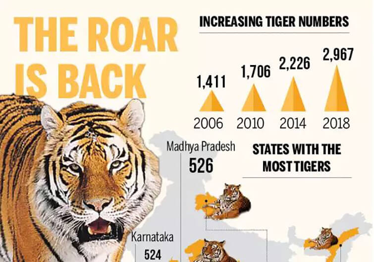
    India’s tiger population has reached a new high at 2,367.

    Before reading this newscard, try these PYQs:

    1. The term ‘M-STrIPES’ is sometimes seen in the news in the context of: (CSP 2017)

    (a) Captive breeding of Wild Fauna

    (b) Maintenance of Tiger Reserves

    (c) Indigenous Satellite Navigation System

    (d) Security of National Highways

    Q.Consider the following protected areas: (CSP 2012)

    1. Bandipur
    2. Bhitarkanika
    3. Manas
    4. Sunderbans

    Which of the above are declared Tiger Reserves?

    (a) 1 and 2 only

    (b) 1, 3 and 4 only

    (c) 2, 3 and 4 only

    (d) 1, 2, 3 and 4

    All India Tiger Estimation

    MP-tops-country-with-526-tigers-as-per-All-India-Tiger-Estimation-2018
    • The tiger count is prepared after every four years by the National Tiger Conservation Authority (NTCA) provides details on the number of tigers in the 18 tiger reign states with 50 tiger reserves.
    • However, this time, the census also included data collected from the rough terrains of north-eastern states which were not possible due to logistic constraints before.
    • The entire exercise spanned over four years is considered to be the world’s largest wildlife survey effort in terms of coverage and intensity of sampling.
    • Over 15, 000 cameras were installed at various strategic points to capture the movement of tigers. This was supported by extensive data collected by field personnel and satellite mapping.

    Details of the report

    • India has 70% of the world’s tigers, says the report.
    • Madhya Pradesh has the highest number of tigers at 526, closely followed by Karnataka (524) and Uttarakhand (442).
    • Chhattisgarh and Mizoram saw a decline in tiger population and all other States saw a “positive” increase, according to a press statement.

    Implementing CATS frameworks

    • India had embarked upon assessing management interventions through the globally developed Conservation Assured | Tiger Standards (CA|TS) framework.
    • This framework will now be extended to all fifty tiger reserves across the country.

    Back2Basics: Project Tiger

    • Project Tiger is a tiger conservation programme launched in April 1973 during PM Indira Gandhi’s tenure.
    • In 1970 India had only 1800 tigers and Project Tiger was launched in Jim Corbett National Park.
    • The project is administrated by the National Tiger Conservation Authority (NTCA).
    • It aims at ensuring a viable population of Bengal tigers in their natural habitats, protecting them from extinction etc.
    • Under this project the govt. has set up a Tiger Protection Force to combat poachers and funded relocation of villagers to minimize human-tiger conflicts.
  • Global Forest Resources Assessment (FRA)

    India has ranked third among the top 10 countries that have gained in forest areas in the last decade a/c to the latest Global Forest Resources Assessment (FRA).

    Possible prelim question:

    Q.The Global Forest Resources Assessment Report recently seen in news is published by-

    a) UN-FAO

    b) UN Forum on Forests

    c) International Union of Forest Research Organizations

    d) None of these

    India gains in forest cover

    • The top 10 countries that have recorded the maximum average annual net gains in a forest area during 2010-2020 are China, Australia, India, Chile, Vietnam, Turkey, the US, France, Italy and Romania.
    • India accounts for two per cent of total global forest area.
    • Globally, 12.5 million people were employed in the forestry sector. Out of this, India accounted for 6.23 million, or nearly 50 per cent.

    Global prospects

    • The Asian continent reported the highest net gain in a forest area in 2010-2020, according to the report.
    • It recorded a 1.17 million hectares (ha) per year net increase in forests in the last decade.
    • However, the South Asia sub-region reported net forest losses during 1990-2020.
    • But, this decline would have been much higher without the net gain in India’s forest during this period, according to FRA 2020.

    How did India gain?

    • The FRA 2020 has credited the government’s Joint Forest Management programme for the significant increase in community-managed forest areas in the Asian continent.
    • The forest area managed by local, tribal and indigenous communities in India increased from zero in 1990 to about 25 million ha in 2015, the assessment said.
    • India has been taking up massive afforestation and plantation schemes.

    About Global Forest Resources Assessment

    • The Global Forest Resources Assessment (FRA) reports on the status and trends of the world’s forest resources.
    • It is led by the Forestry Department of the Food and Agriculture Organization of the UN.
    • It reports the extent of the world’s forest area as well as other variables, including land tenure and access rights, sustainable forest management (SFM), forest conservation, and sustainable use.

    Back2Basics: Defining forests as per FRA

    • The definition excludes tree stands in agricultural production systems, such as fruit tree plantations, oil palm plantations, olive orchards, and agroforestry systems when crops are grown under tree cover.

    The FAO definition of a forest includes:

    • land spanning more than 0.5 hectares with trees higher than 5 meters and a canopy cover of more than 10 per cent, or trees able to reach these thresholds in situ
    • does not include land that is predominantly under agricultural or urban land use
  • In news: Ghazipur Landfill

    The Ghazipur landfill site rises by nearly 10 metres a year and is expected to surpass the height of Qutub Minar and other vertical structures in the country.

    Try this PYQ from CSP 2016:

    Q.What can be the impact of excessive/inappropriate use of nitrogenous fertilizers in agriculture?

    1. Proliferation of nitrogen-fixing microorganisms in soil can occur.
    2. Increase in the acidity of soil can take place.
    3. Leaching of nitrate to the ground-water can occur.

    Select the correct answer using the code given below:

    (a) 1 and 3 only

    (b) 2 only

    (c) 2 and 3 only

    (d) 1, 2 and 3

    What are Landfills?

    • A landfill site, also known as a tip, dump, rubbish dump, garbage dump, or dumping ground, is a site for the disposal of waste materials.
    • Some landfill sites are also used for waste management purposes, such as temporary storage, consolidation and transfer, or for various stages of processing waste material, such as sorting, treatment, or recycling.

    Threats posed by landfills

    Landfills have the potential to cause a number of issues. Infrastructure disruption, such as damage to access roads by heavy vehicles, may occur amongst others.

    1) Leachate

    • When precipitation falls on open landfills, water percolates through the garbage and becomes contaminated with suspended and dissolved material, forming leachate.
    • If this is not contained it can contaminate groundwater.

    2) Decomposition gases

    • Rotting food and other decaying organic waste create decomposition gases, especially CO2 and CH4 from aerobic and anaerobic decomposition, respectively.
    • Both processes occur simultaneously in different parts of a landfill.

    3) Other threats

    • Poorly run landfills may become nuisances because of vectors such as rats and flies which can spread infectious diseases.
    • The occurrence of such vectors can be mitigated through the use of daily cover.
    • Other potential issues include wildlife disruption due to occupation of habitat and animal health disruption caused by consuming waste from landfills, dust, odour, noise pollution, and reduced local property values.
  • What is Khazan Farming System?

    The Salim Ali Bird Sanctuary in low-lying floodplains of Goa is characterized by an estuarine agricultural system called Khazan farming.

    Try this question from our AWE initiative:

    How far is the Integrated Farming System (IFS) helpful in sustaining agricultural production? (10 Marks)

    Khazan Farming

    • The low-lying floodplains of Goa host an estuarine agricultural system called Khazan farming.
    • This system is a carefully designed topo-hydro-engineered agro-aquacultural ecosystem mainly based on the regulation salinity and tides.

    How does it work?

    • Centuries ago, people in this region reclaimed low-lying brackish coastal floodplains and mangrove forests.
    • They constructed bunds using locally available material to prevent the ingress of saltwater, which killed the halophilic mangroves.
    • To control the flow of tidal waters, they built openings in bunds fitted with one-way gates.
    • These channels would fill in with the oncoming tide and bring with them fish, crab and shrimp, and the gates would automatically shut when the water level was equal on both sides.
    • This prevented the water from overflowing into the fields used to grow paddy and which has a low tolerance to salt.
    • When the tide receded, these gates would open outwards automatically, allowing the water to drain out.
    • During this time, a bag net was set at the gate to catch fish that had entered in earlier.

    Benefits of Khazan

    • Every bit of space was precious and used efficiently — the bunds were used to grow a variety of vegetables.
    • The Khazan system allowed for the farmer and the fisher to harmoniously coexist and was the key to sustaining what is considered Goa’s staple — fish, curry and rice.

    Why is it neglected these days?

    • Today, for various reasons, but primarily due to post-independence agrarian reforms of 1961, these lands largely lie fallow and are in a state of decay.
    • Lack of cultivation and maintenance of the bunds and sluice gates is leading to their breaching and the natural reclamation of these fallow lands by mangroves.
    • Moreover, mangroves are protected by law and it is illegal to cut them.
    • Areas that have these trees growing on them also come under the purview of the coastal regulation zone (CRZ); according to the 2011 notification, the mangrove areas are classified as CRZ I and cannot be developed upon.

    Back2Basics: Salim Ali Bird Sanctuary

    • The Salim Ali Bird Sanctuary is Goa’s smallest protected area — it comprises barely two square kilometres of lush mangrove forests.
    • The sanctuary is located on ChorĂŁo, one of Goa’s estuarine islands in the Mandovi river approximately five kilometres from capital Panaji.
    • The sanctuary and its surrounds are home to marsh crocodiles, smooth-coated otter, the unique glossy-marsh snake that feeds on crabs, mud lobsters, sap-sucking sea slugs, among others.