💥Join UPSC 2027,2028 Mentorship (July Batch) + XFactor Notes & Microthemes PDF

Subject: Conservation & Mitigation

1. Conservation Progs.
2. Worldwide initiatives
3. Mitigation Strategies
4. Conventions and Protocols

  • Species in news: Alpine Musk Deer

    Why in the News?

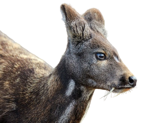
    A Central Zoo Authority (CZA) report reveals a major conservation error — the critically endangered Alpine musk deer was wrongly replaced by the Himalayan musk deer in India’s breeding programmes.

    Species in news: Alpine Musk Deer

    Back2Basics: Central Zoo Authority (CZA):

    • Establishment: Formed in 1992 under Wildlife (Protection) Act, 1972.
    • Mandate: Captive breeding, zoo oversight, and assigning species to zoos.
    • Expanded Scope (2022): Includes rescue centres, off-display facilities, and conservation breeding centres.

    About Alpine Musk Deer (Moschus chrysogaster):

    • Not a true Deer: closer to goats and antelopes (Bovidae).
    • Musk Sac: Males have a visible musk sac between the testes.
    • Canines: Grows fang-like canines during the mating season.
    • Habitat: Found at 3,000–5,000 m in forests of the Himalayas.
    • Range: India (J&K, HP, Uttarakhand, Sikkim, Arunachal), Nepal, Bhutan, China.
    • Diet: Eats grasses, leaves, lichens, mosses, and twigs.
    • Behaviour: Solitary and crepuscular (active at dawn/dusk).
    • Legal Protection:  IUCN Status Critically Endangered (2014), CITES Appendix I; Indian Wildlife Act- Schedule I.
    • Threats: Poaching for musk and habitat loss.
    • Key Habitats: Askot, Gangotri & Kedarnath Wildlife Sanctuaries (Uttarakhand).
    [UPSC 2020] Which of the following are the most likely places to find the musk deer in its natural habitat?

    1. Askot Wildlife Sanctuary 2. Gangotri National Park

    3. Kishanpur Wildlife Sanctuary 4. Manas National Park

    Options: (a) 1 and 2 only * (b) 2 and 3 only (c) 3 and 4 only (d) 1 and 4 only


  • [31st July 2025] The Hindu Op-ed: Restoring mangroves can turn the tide on India’s coastal security 

    PYQ Relevance:

    [UPSC 2019] Discuss the causes of depletion of mangroves and explain their importance in maintaining coastal ecology.

    Linkage: The article explicitly details the importance of mangroves, stating they are “critical in India’s pursuit of climate resilience, biodiversity conservation, and the empowerment of coastal communities”. It explains their role as “natural barriers, protecting coastal communities from cyclones, tidal surges, and erosion”, and their significance in “biodiversity conservation”. The article also discusses the threats leading to their “depletion,” such as “urban expansion, aquaculture, pollution, and changing climate patterns”.


    Mentor’s Comment:  India’s mangrove forests have come into focus due to growing efforts to restore and protect them amid increasing threats from urban expansion, climate change, and pollution. Recent successful restoration projects in Tamil Nadu, Gujarat, and Mumbai, along with support from government missions and private partners, highlight India’s growing role in mangrove conservation. These forests are vital for climate resilience, coastal protection, and biodiversity, making their preservation a national priority.

    Today’s editorial analyses India’s growing efforts to restore mangrove forests. This topic is important for GS Paper III (Environment) in the UPSC mains exam.

    _

    Let’s learn!

    Why in the News?

    Recently, mangrove restoration efforts in Tamil Nadu, Gujarat, and Mumbai have been successful.

    What is the extent of Mangroves in India?

    • India’s total mangrove cover is 4,992 sq km, accounting for 0.15% of the country’s geographical area (as per ISFR 2021).
    • West Bengal, Gujarat, and the Andaman & Nicobar Islands hold the largest mangrove areas, with West Bengal (Sundarbans) alone covering over 42% of the total.

    Why are mangroves vital for climate and coastal resilience in India?

    • Natural Coastal Shield: Mangroves act as buffers against cyclones, storm surges, and coastal erosion. Eg: During the 2004 tsunami, villages protected by mangroves in Tamil Nadu suffered less damage compared to those without them.
    • Climate Change Mitigation: They store “blue carbon” in biomass and deep soil, helping to absorb excess CO₂. Eg: India’s mangroves contribute significantly to carbon sequestration, aiding in climate targets under the Paris Agreement.
    • Biodiversity Hotspots: Provide breeding grounds for fish, crabs, birds, and other marine life. Eg: Thane Creek Flamingo Sanctuary in Mumbai supports over 180 bird species due to nearby mangroves.
    • Livelihood Support for Communities: Sustain traditional occupations like fishing, honey gathering, and crab farming. Eg: Sunderbans communities rely on mangroves for fishing and honey collection.
    • Disaster Risk Reduction: Reduce the impact of natural disasters by slowing floodwaters and stabilising shorelines. Eg: In Odisha, mangroves helped minimise damage during Cyclone Phailin (2013).

    What threatens India’s mangroves?

    • Urbanisation and Industrial Expansion: Mangrove areas are cleared for ports, housing, and industrial zones. Eg: Mangrove loss in Mumbai due to Navi Mumbai airport construction.
    • Aquaculture and Agriculture Encroachment: Conversion of mangrove land into shrimp farms or paddy fields disrupts ecosystems. Eg: Andhra Pradesh lost mangroves to extensive aquaculture projects.
    • Pollution: Discharge of industrial effluents, plastic, and sewage harms mangrove health. Eg: Thane Creek, Mumbai, faces heavy pollution impacting biodiversity.
    • Climate Change and Sea Level Rise: Changes in salinity, temperature, and rising sea levels affect mangrove regeneration. Eg: Sundarbans face submergence and loss due to rising sea levels.
    • Overexploitation of Resources: Excessive collection of wood, honey, and fodder leads to degradation. Eg: In West Bengal, unsustainable practices by local communities reduce forest cover.

    How has community involvement aided mangrove restoration in Tamil Nadu?

    • Collaborative Restoration Projects: Community members partnered with institutions like the M.S. Swaminathan Research Foundation and the Tamil Nadu Forest Department for restoring degraded mangroves. Eg: In Muthupettai’s Pattuvanachi estuary, locals helped implement a 115-hectare restoration plan.
    • Tidal Canal Digging for Hydrology Restoration: Villagers participated in digging 19 major canals to restore natural tidal flow, crucial for mangrove survival. Eg: This intervention successfully revived water movement in Muthupettai, enabling mangrove regrowth.
    • Seed Collection and Plantation: Locals actively collected and planted seeds of native mangrove species like Avicennia and Rhizophora. Eg: Over 4.3 lakh Avicennia seeds and 6,000 Rhizophora propagules were planted by community members.
    • Removal of Invasive Species: Community groups helped clear invasive weeds like Prosopis juliflora, which compete with mangroves for space and nutrients. Eg: In Kazhipattur near Buckingham Canal, Chennai, invasive plants were removed before mangrove restoration began.
    • Support for Green Missions and Monitoring: Local residents supported and maintained mangrove cover under the Green Tamil Nadu Mission, ensuring long-term success. Eg: Community participation helped double Tamil Nadu’s mangrove area from 4,500 ha to 9,000 ha (2021–2024).

    What is the role of corporate partnerships in mangrove revival in Mumbai?

    • Financial and Technical Support: Amazon’s Right Now Climate Fund invested $1.2 million (₹10.3 crore) in a restoration project along Thane Creek, enabling large-scale ecological rehabilitation.
    • Pollution Control and Ecosystem Restoration: Partnered with Hasten Regeneration and Brihanmumbai Municipal Corporation to install trash booms that intercept plastic waste, aiming to collect 150 tonnes over 3 years while planting 3.75 lakh mangrove saplings.
    • Community Empowerment and Livelihood Generation: Created paid employment opportunities for local women in planting and maintenance, linking ecological recovery with socio-economic upliftment.

    Why is Gujarat leading in mangrove restoration?

    • Ambitious Scale under MISHTI Scheme: Under the Mangrove Initiative for Shoreline Habitats and Tangible Incomes (MISHTI), launched in 2023, Gujarat planted over 19,000 hectares of mangroves within two years—far exceeding the national five-year target of 54,000 hectares.
    • Strategic Coastal Coverage & Biodiversity Focus: Gujarat holds about 23.6% of India’s total mangrove cover, with major plantations in Kutch, Bhavnagar, Surat, and Dumas-Ubhrat. These areas support critical ecological balance, biodiversity, and local livelihoods.
    • Strong Governance, Planning & Local Institutional Support: Efficient coordination between the Gujarat Forest Department, state environment agencies, and local communities has ensured success. Structured coastal mapping, restoration planning, and promotion of ecotourism-linked livelihoods have further strengthened outcomes.

    What are the steps taken by the Indian government? 

    • Green India Mission & State Missions: Through the National Green India Mission and state-level initiatives like the Green Tamil Nadu Mission, the government supports afforestation, ecosystem restoration, and community-based conservation efforts.
    • Inclusion in Coastal Regulation Zone (CRZ) Rules: Mangrove areas are designated as Ecologically Sensitive Zones (ESZ) under the CRZ Notification, restricting construction and promoting their protection through legal safeguards and regulatory oversight.

    Way forward: 

    • Strengthen Community-Based Conservation: Empower local communities through training, incentives, and formal roles in monitoring and maintaining mangroves to ensure sustainable, long-term protection.
    • Integrate Mangroves into Climate and Development Planning: Recognise mangroves as vital climate infrastructure by integrating them into coastal zone management, disaster resilience strategies, and carbon credit frameworks.
  • New Guidelines for Management of Contaminated Sites

    Why in the News?

    The Union Environment Ministry has notified the Environment Protection (Management of Contaminated Sites) Rules, 2025 under the Environment (Protection) Act, 1986.

    About the Environment Protection (Management of Contaminated Sites) Rules, 2025:

    • Nodal Agency: Ministry of Environment, Forest and Climate Change (MoEFCC).
    • Legal Basis: Framed under the Environment (Protection) Act, 1986.
    • Purpose: India’s first dedicated legal framework to identify, clean up, and monitor contaminated sites.
    • Goal: Prevent environmental degradation, enforce clean-up, and ensure polluter accountability.
    • Funding Pattern:
      • Himalayan & Northeast states: 90% Centre – 10% State
      • Other states: 60% Centre – 40% State
      • Union Territories: 100% Centre

    Key Features:

    • Site Classification: Sites categorized as suspected, potentially contaminated, or confirmed, based on scientific evidence.
    • Exclusions: Sites involving radioactive waste, mining, marine oil spills, or municipal solid waste (regulated separately).
    • Transparency & Tracking: Central Pollution Control Board (CPCB) to maintain a real-time online portal with public access.
    • Public Participation:
      • 60-day window for stakeholder feedback post-listing.
      • Final site lists must be published in regional newspapers.
    • Polluter Pays Principle:
      • Identified polluters must bear full remediation cost and repay within 3 months.
      • Land use changes or ownership transfers restricted during/post clean-up.
    • Orphan Sites (No Known Polluter): Clean-up funded through:
      • Environment Relief Fund
      • Environmental violation penalties
      • Government budgetary support
    • Voluntary Remediation: Private entities with technical capacity may remediate sites with landowner consent.
    • Monitoring Committees: State and Central-level bodies to oversee implementation and submit annual compliance reports.

    Back2Basics: Environment (Protection) Act, 1986

    • Enactment: In response to the Bhopal Gas Tragedy; derives authority from Article 253 of the Constitution.
    • Objective: To protect and improve the environment and prevent hazards to life and property.
    • Significance: Acts as India’s umbrella environmental legislation, coordinating with the Water Act (1974) and Air Act (1981).
    • Key Provisions:
      • Pollution standards via Environment (Protection) Rules.
      • Hazardous Waste Rules, 1989 – manage toxic waste.
      • Chemical Safety Rules – control handling of hazardous chemicals.
      • Cells Rules, 1989 – govern gene tech and genetically modified organisms.
    • Power: Empowers the Central Government to act directly for environmental protection.


    [UPSC 2019] Consider the following statements:

    The Environment Protection Act, 1986 empowers the Government of India to:

    1. State the requirement of public participation in the process of environmental protection, and the procedure and manner in which it is sought.

    2. Lay down the standards for emission or discharge of environmental pollutants from various sources.

    Which of the statements given above is/are correct?

    Options: (a) 1 only (b) 2 only* (c) Both 1 and 2 (d) Neither 1 nor 2


  • Grassland Bird Census in Kaziranga

    Why in the News?

    The Prime Minister recently highlighted a first-of-its-kind grassland bird census in Kaziranga National Park, Assam.

    About the Bird Census:

    • Significance: India’s first-ever dedicated census of grassland birds
    • Led by: Chiranjib Bora (PhD scholar), supported by INSPIRE Fellowship from the Department of Science & Technology
    • Organised by: Park authorities, scientists, and conservationists
    • Objective:
      • Document rare, endemic, and threatened grassland bird species
      • Focused on 10 priority species endemic to the Brahmaputra floodplains

    Methodology Used:

    • Passive Acoustic Monitoring (PAM):
      • Recording devices placed in tall trees during breeding season
      • Recordings captured across 29 locations over 3 days
      • Ideal for detecting small, shy, camouflaged birds not easily visible
    • Sound Identification Tools:
      • BirdNet: Machine learning tool used to identify bird calls
      • Spectrograms: Visual analysis of sound patterns; Final identifications verified by ornithologists

    Key Findings:

    • Total Species Recorded: 43 grassland bird species
    • Priority Species Identified: Bengal Florican, Swamp Francolin, Finn’s Weaver, Jerdon’s Babbler, Black-breasted Parrotbill, among others
    • Major Discovery: A breeding colony of over 85 Finn’s Weaver nests—first-ever documentation
    [UPSC 2014] If you walk through countryside, you are likely to see some birds stalking alongside the cattle to seize the insects disturbed by their movement through grasses. Which of the following is/are such bird/birds?

    1. Painted Stork  2. Common Myna  3. Black-necked Crane

    Options: (a) 1 and 2 (b) 2 only* (c) 2 and 3 (d) 3 only


  • In news: Kyoto Protocol

    Why in the News?

    Vijai Sharma, a 1974-batch IAS officer and architect of India’s climate diplomacy, who helped shape the Kyoto Protocol for safeguarding the interests of developing countries like India, has passed away.

    About Kyoto Protocol:

    • Adopted: 11 December 1997 (UNFCCC COP-3, Kyoto, Japan); Came into Force: 16 February 2005
    • Legal Status: Legally binding on developed (Annex I) countries
    • Parent Treaty: United Nations Framework Convention on Climate Change (1992)
    • Objective: Reduce greenhouse gas emissions and address climate change
    • Principle: Common but Differentiated Responsibilities and Respective Capabilities (CBDR-RC)
    • Parties: 192 ratified; key non-parties include United States and Canada

    Key Features:

    • Emission Targets:
      • Annex B nations to cut emissions by 5% below 1990 levels (2008–2012)
      • Doha Amendment (2012): 18% cut for 2013–2020
    • Greenhouse Gases Covered:
      • Carbon dioxide, Methane, Nitrous oxide, Hydrofluorocarbons, Perfluorocarbons, Sulfur hexafluoride
    • Market Mechanisms:
      • Clean Development Mechanism (CDM): Carbon credits via projects in developing nations
      • Joint Implementation (JI): Emission reduction between Annex I countries
      • International Emissions Trading: Trade surplus emission units
    • Monitoring and Enforcement:
      • Mandatory reporting and independent verification
      • Compliance Committee oversight
      • Land Use, Land-Use Change and Forestry (LULUCF) included; aviation/shipping excluded
    • Equity Element:
      • No binding targets for developing nations like India and China
      • Developed nations held accountable for historical emissions

    Vijai Sharma’s Contributions:

    • Climate Negotiations Leader: India’s chief negotiator (1995–2001), led G77+China, defended equity and exemptions for developing nations
    • Policy Architect: Helped shape CDM governance, promoted India’s clean-tech access
    • Environmental Reformer: As Environment Secretary (2008–2010), improved clearance processes
    • Legacy: Called “Sir Humphrey Sharma” for his sharp wit and bureaucratic skill; key figure in India’s Kyoto-era climate diplomacy
    [UPSC 2016] Consider the following pairs:

    Terms sometimes seen in the news : Their origin

    1. Annex-I Countries : Cartagena Protocol

    2. Certified Emissions Reductions : Nagoya Protocol

    3. Clean Development Mechanisms : Kyoto Protocol

    Which of the pairs given above is/are correctly matched?

    Options: (a) 1 and 2 only (b) 2 and 3 only (c) 3 only* (d) 1, 2 and 3


  • Sundarbans set to become India’s Second-Largest TR

    Why in the News?

    The proposal to expand the Sundarbans Tiger Reserve by 1,100 sq km has received clearance from the National Tiger Conservation Authority (NTCA) and awaits approval from National Board for Wildlife (NBWL).

    Sundarbans set to become India’s Second-Largest TR

    About Sundarbans Tiger Reserve (STR):

    • Location: Situated in South and North 24-Parganas districts, West Bengal; lies at the southern tip of the Gangetic Delta.
    • Area: Presently 2,585.89 sq km; expansion to 3,629.57 sq km under proposal.
    • Status: Notified as a Tiger Reserve, National Park, Biosphere Reserve; part of the UNESCO World Heritage Site.
    • Unique Feature: World’s only mangrove forest with a viable tiger population.
    • Tiger Count: Over 100 tigers – 80 in core area, 21 in adjoining forests.
    • Landscape: Interconnected estuaries, tidal creeks, and 105 mangrove-covered islands.
    • Flora: Dominated by mangrove species like Avicennia, Rhizophora, Heritiera.
    • Fauna: Includes Royal Bengal Tigers, Fishing Cats, Estuarine Crocodiles, Irrawaddy Dolphins, King Cobras, and endangered reptiles and birds.
    • Boundaries:
      • East: Bangladesh border (Raimangal, Harinbhanga rivers)
      • South: Bay of Bengal
      • North/West: Matla, Bidya, Gomdi Rivers

    Back2Basics: Tiger Reserves in India

    • Overview: A Tiger Reserve is a legally notified area under the Wildlife (Protection) Act, 1972 for the conservation of tigers and biodiversity.
    • Governing Authority: National Tiger Conservation Authority (NTCA), Ministry of Environment, Forest and Climate Change.
    • Origin: Initiated under Project Tiger, launched in 1973.
    • Structure:
      • Core Zone: Highly protected; no human activity allowed; declared as National Park or Sanctuary.
      • Buffer Zone: Surrounds core; allows regulated human use and supports conservation-compatible livelihoods.

    Tiger Reserve Landscape in India (as of 2025):

    • Total Reserves: 58 (up from 46 in 2014)
    • Largest Reserve: Nagarjunasagar-Srisailam, Andhra Pradesh – 3,727.82 sq km
    • Oldest Reserve: Corbett Tiger Reserve, Uttarakhand – established in 1973
    • Newest Reserves: Guru Ghasidas (Chhattisgarh), Ranipur (Uttar Pradesh), Ramgarh Vishdhari (Rajasthan)
    • Top State: Madhya Pradesh – 7 Tiger Reserves
    • Tiger Density: Bandipur TR > Corbett TR > Kaziranga TR (148, 18.6 tigers/sq. km.)
    • Global Tiger Day: Celebrated on 29th July every year


    [UPSC 2020] Among the following Tiger Reserves, which one has the largest area under “Critical Tiger Habitat”?”

    Options: (a) Corbett (b) Ranthambore (c) Nagarjunsagar-Srisailam* (d) Sunderbans


  • [28th July 2025] The Hindu Op-ed: How is India preparing against GLOF events?

    PYQ Relevance:

    [UPSC 2024] What is disaster resilience? How is it determined? Describe various elements of a resilience framework. Also mention the global targets of the Sendai Framework for Disaster Risk Reduction (2015-2030).

    Linkage: The article explicitly states that the NDMA has “markedly accelerated its efforts to manage these increasing risks” and initiated a “proactive shift from mere post-disaster response to risk reduction through its Committee on Disaster Risk Reduction (CoDRR)”. This directly links to the concept of “disaster resilience” and “Disaster Risk Reduction (DRR),” which are central to India’s preparedness strategy for GLOF events.


    Mentor’s Comment:  On July 8, 2025, Nepal experienced a major Glacial Lake Outburst Flood (GLOF), which triggered a flash flood along the Lende River, destroying a China-built friendship bridge and disabling four hydropower plants, cutting off 8% of Nepal’s power supply. This catastrophe highlights the growing threat of GLOFs due to glacial melt from rising temperatures in the Himalayas. The incident has raised concerns over the lack of trans-boundary early warning systems, particularly between China and Nepal. It also drew attention to India’s vulnerability, as the Indian Himalayan Region (IHR) contains 7,500 glacial lakes, many at high risk of GLOF due to climate change, poor monitoring infrastructure, and lack of early warning systems. India’s National Disaster Management Authority (NDMA) has responded by launching a national programme targeting 195 at-risk glacial lakes, focusing on hazard assessment, early warning systems, risk mitigation, and community engagement.

    Today’s editorial analyses the major Glacial Lake Outburst Flood (GLOF) in Himalaya region. This topic is important for GS Paper III (Environment) in the UPSC mains exam.

    _

    Let’s learn!

    Why in the News?

    Recently, Nepal faced a major Glacial Lake Outburst Flood (GLOF), which led to a sudden flash flood along the Lende River.  

    What are GLOFs?

    • GLOFs are sudden floods caused by the breach of natural or man-made dams holding glacial lakes, releasing large volumes of water.
    • Himalayan Spread: The Himalayas across India, Nepal, Bhutan, and Tibet host thousands of glacial lakes, many near international borders. India has 7,500+ glacial lakes, with 200+ deemed potentially dangerous.


    What are their transboundary risks in the Himalayas?

    • Trans-boundary Risk: GLOFs from upstream countries (e.g. China) can impact downstream nations (India, Nepal, Bhutan) without early warning. Eg: The July 2024 Tibetan GLOF damaged Nepal’s Rasuwagadhi hydropower project with no prior alert.
    • Lack of Data Sharing: Minimal real-time data exchange between neighbours hampers early warning and risk management. Eg: Nepal got no warning from China during the 2024 GLOF.

    How has climate change increased GLOF frequency in the IHR?

    • Accelerated Glacier Melting: Rising temperatures cause glacier retreat and formation of unstable glacial lakes. Eg: Milam Glacier, Uttarakhand shows rapid retreat, increasing GLOF risk.
    • Extreme Precipitation: Intense rainfall from climate change can overfill lakes, causing breaches. Eg: Gya GLOF (2014) in Ladakh followed heavy rainfall, damaging infrastructure.
    • Increased Landslides: Thawing permafrost and unstable slopes trigger landslides into lakes, displacing water and causing GLOFs. Eg: 2013 Chorabari Glacier landslide near Kedarnath worsened the flood impact.

    What measures has India taken for GLOF mitigation?

    • Early Warning Systems (EWS): Installed to detect rising water levels and trigger alerts. Eg: EWS at South Lhonak Lake, Sikkim before 2023 GLOF.
    • Satellite Monitoring: ISRO-NRSC use remote sensing to track glacial lakes. Eg: Monitored via Bhuvan portal in Ladakh, Uttarakhand, Himachal Pradesh.
    • Risk Mapping: NMSHE identifies high-risk areas for targeted intervention. Eg: Studies in Kinnaur and Chamoli flagged vulnerable lakes.
    • Engineering Measures: Lake drainage and structural control to prevent overflow. Eg: Work at Tsho Rolpa Lake (Nepal) as a replicable model.
    • Community Preparedness: NDMA and states run drills and awareness programs. Eg: Mock drills in Uttarkashi and Kullu.

    What are the gaps? 

    • Weak Early Warning Systems (EWS): India lacks real-time sensors, automated sirens, and alert mechanisms. Eg: No early alerts during Chamoli disaster (2021).
    • Low Community Preparedness: Most villages in Sikkim and Uttarakhand lack evacuation protocols and disaster training.
    • Poor Transboundary Coordination: Minimal data sharing with China hinders early action in regions like Arunachal Pradesh.
    • Infrastructure Vulnerability: Bridges and dams not designed for GLOFs.
      Eg: Chungthang dam breach (2023) exposed weak infrastructure.
    • Limited Scientific Capacity: Shortage of glaciologists, risk modelers, and ground validation limits NDMA’s effectiveness.

    Way forward: 

    •  Strengthen Early Warning Systems: Deploy real-time sensors, sirens, and automated alerts in high-risk zones.
    • Enhance Transboundary Cooperation: Establish formal data-sharing agreements with China, Nepal, and Bhutan.
    • Build Local Preparedness: Conduct regular community drills, awareness drives, and evacuation planning.
    • Climate-Resilient Infrastructure: Design dams, bridges, and power projects to withstand GLOF surges.
    • Invest in Research & Capacity: Train glaciologists, improve satellite-ground integration, and support Himalayan climate studies.
  • The scientist who made ‘mangroves’ a buzzword

    Why in the News?

    World Mangrove Day was observed on July 26. The occasion also recalled the pioneering role of M.S. Swaminathan in promoting mangrove conservation through initiatives like the International Society for Mangrove Ecosystems (ISME), GLOMIS, and the fishbone canal method of restoration.

    Role of M.S. Swaminathan in mangrove conservation

    • As early as 1989, he advocated using mangroves for climate resilience in coastal areas.
    • Proposed developing salinity-tolerant crops (e.g., rice) using mangrove genes.
    • Played a key role in founding the International Society for Mangrove Ecosystems (ISME) in 1990, promoting global knowledge exchange.
    • Co-authored the Charter for Mangroves, which was later included in the World Charter for Nature (1992) by the UN.
    • Led Community-Based Restoration in India through the M.S. Swaminathan Research Foundation (MSSRF).

    What is the ‘fishbone canal’ method? What are its advantages?

    The method mimics the natural branching pattern of rivers. It allows tidal waters to penetrate deep into degraded mangrove areas. Eg: In Tamil Nadu’s Pichavaram, fishbone canals revived previously stagnant mangrove zones, promoting natural seed dispersal.

    Advantages of the method

    1. Facilitates Natural Regeneration: By improving hydrology, it creates conditions suitable for natural mangrove seedling establishment without extensive manual planting. Eg: In Odisha’s Bhitarkanika, the method led to spontaneous growth of native mangrove species.
    2. Cost-Effective: Compared to large-scale planting, this method is less resource-intensive 
    3. It preserves ecosystem integrity.

    How have global and national initiatives reshaped mangrove management?

    • Shift Towards Community-Based Conservation: Focus has moved from government-led to community-driven models, recognising local knowledge and stakeholder participation. Eg: Eg: Sundarbans’ Joint Forest Committees empower villagers in conservation.
    • Integration with Climate Resilience Strategies: Mangroves are now seen as vital for disaster risk reduction and carbon sequestration. Eg: Indonesia’s “Mangroves for Coastal Resilience” project links mangrove conservation with coastal protection and blue carbon goals.
    • Technological Interventions and Scientific Planning: Use of GIS mapping, remote sensing, and hydrological modelling has made restoration more precise and scalable. Eg: In Andhra Pradesh, the Integrated Coastal Zone Management Project used satellite data to identify degraded mangrove areas for targeted restoration.

    How did India’s mangrove policy evolve post-1980 ?

    • CRZ Inclusion (1991): Mangroves declared ecologically sensitive under CRZ Rules, restricting commercial activity.
    • Post-Tsunami Shift (2004): Indian Ocean Tsunami highlighted mangroves as bio-shields, leading to their inclusion in disaster risk and coastal zone policies.
    • Boost in Support (Post-2005): Initiatives like the National Coastal Mission and remote sensing-based mapping promoted monitoring and restoration.

    What are ISME and GLOMIS?

    • ISME (International Society for Mangrove Ecosystems) is a global non-profit organization founded in 1990 to promote the conservation, restoration, and sustainable use of mangrove ecosystems through research, training, and international cooperation. It also offers technical support and capacity building for sustainable mangrove management.
    • GLOMIS (Global Mangrove Database and Information System), developed by ISME, is a centralized database that provides scientific data, GIS mapping, and case studies to support effective mangrove management and policymaking worldwide. GLOMIS serves as a database for mangrove species, restoration efforts, and GIS data.

    Way forward: 

    • Strengthen Community-Based Restoration: Empower local communities through training, sustainable livelihood support, and participation in restoration using techniques like the ‘fishbone canal’ method for greater ecological success.
    • Leverage Technology and Global Networks: Use remote sensing, GIS, and platforms like GLOMIS for monitoring mangrove health, while collaborating with international bodies like ISME to adopt best global practices.

    Mains PYQ:

    [UPSC 2019] Discuss the causes of depletion of mangroves and explain their importance in maintaining coastal ecology.

    Linkage: This question is directly and explicitly about mangroves, focusing on two key aspects: their depletion and their importance in maintaining coastal ecology. The fact that such a detailed question appeared in the examination signifies the recognized environmental importance and public awareness surrounding mangroves. A scientist’s work to popularize mangroves would logically contribute to this level of public and academic interest.

  • Ramsar COP15 opens in Zimbabwe

    Why in the News?

    Delegates from 172 countries convened in Victoria Falls, Zimbabwe, for the 15th Meeting of the Conference of the Contracting Parties (COP15) to the Ramsar Convention on Wetlands.

    Highlights of Ramsar COP15

    • Theme: Protecting Wetlands for Our Common Future
    • Host Nation: Zimbabwe (holds presidency of the Ramsar Convention for 3 years)
    • Expected Outcome: Adoption of the Victoria Falls Declaration, a global framework to protect wetlands

    About the Ramsar Convention:

    • Adopted on: 2 February 1971, in Ramsar, Iran.
    • Objective: Conserve and ensure the wise use of wetlands globally.
    • Key Functions:
      • Identify wetlands of international importance.
      • Promote sustainable management practices.
      • Foster international cooperation in wetland conservation.
    • Governing Body:
      • Conference of the Contracting Parties (COP) meets every 3 years.
      • Reviews implementation, adopts site designations, budgets, and policy actions.
      • Includes member + non-member states, IGOs, and NGOs as observers.

    Criteria for Ramsar Site Designation:

    A wetland must meet at least one of the following 9 criteria:

    1. Unique or rare wetland type.
    2. Habitat for endangered, vulnerable, or endemic species.
    3. Crucial for migratory waterbirds.
    4. High ecological, hydrological, or biodiversity value.
    5. Supports ecosystem services (e.g., flood control, water purification).
    6. Provides cultural or spiritual value.
    7. Serves sustainable community livelihoods.
    8. Holds scientific or educational importance.
    9. Requires global cooperation due to threats.

    India and the Ramsar Convention:

    • Joined on: 1 February 1982.
    • First Ramsar Site: Chilika Lake (Odisha), 1981.
    • As of July 2025:
      • Total sites: 91
      • Total area: ~13.58 lakh hectares
      • % of India’s wetland area under Ramsar: ~10%
    • Top States: Tamil Nadu: 20 sites (highest); Uttar Pradesh: 10 sites
    • Note: India has never chaired a Ramsar COP session.

    Global Snapshot and Other Facts:

    • Total Members: 171 countries.
    • Leading Countries:
      • United Kingdom: 175 sites (most)
      • Mexico: 142 sites
      • Bolivia: Largest area (~1.48 lakh sq. km under protection)
    • World Wetlands Day: Celebrated on 2 February annually.
    • Montreux Record: Register for Ramsar sites under serious threat needing urgent conservation.
    [UPSC 2019] Consider the following statements:

    1. Under Ramsar Convention, it is mandatory on the part of the Government of India to protect and conserve all the wetlands in the territory of India.

    2. The Wetlands (Conservation and Management) Rules, 2010 were framed by the Government of India based on the recommendations of Ramsar Convention.

    3. These Rules also encompass the drainage area or catchment regions of the wetlands as determined by the authority.

    Which of the statements given above is / are correct?

    Options: (a) 1 and 2 only (b) 2 and 3 only (c) 3 only* (d) 1, 2 and 3


  • 150 years of Jim Corbett

    Why in the News?

    As India marks Jim Corbett’s 150th birth anniversary (1875–2025), it reflects on his legacy as a hunter, naturalist, author, and conservationist—after whom Corbett National Park is named.

    https://www.downtoearth.org.in/wildlife-biodiversity/150-years-of-jim-corbett-will-the-real-carpet-sahib-please-stand-up 

    Who was Jim Corbett?

    • Full Name: Edward James Corbett (1875–1955), nicknamed Carpet Sahib in Kumaon.
    • Profession: British hunter, naturalist, author, and later a wildlife conservationist.
    • Famous Books: Man-Eaters of Kumaon, The Man-Eating Leopard of Rudraprayag, My India, Jungle Lore, Tree Tops.
    • Hunter Turned Hero:
      • Known for tracking and killing man-eating tigers and leopards in Kumaon and Garhwal.
      • Used patient observation and deep knowledge of terrain and animal behaviour.
    • Shift to Conservation:
      • Grew concerned about dwindling tiger numbers and deforestation.
      • Advocated for wildlife protection and ecological balance.
    • Commemoration: India’s first national park was renamed Jim Corbett National Park in 1957 in his honour.

    Back2Basics: Jim Corbett National Park

    • Established: 1936 as Hailey National Park; later renamed in 1957.
    • Location: Nainital district, Uttarakhand; core of Corbett Tiger Reserve.
    • Historical Importance:
      • Launch site of Project Tiger in 1973, India’s flagship tiger conservation programme.
    • Geography:
      • Lies in Shivalik and Outer Himalayan foothills.
      • Rivers: Ramganga, Sonanadi, Mandal, Palain, and Kosi.
      • Area: Over 500 sq km (includes Sonanadi Wildlife Sanctuary as buffer).
    • Biodiversity:
      • Flora: Moist deciduous forest with Sal, Khair, and Sissoo; 600+ plant species.
      • Fauna: Over 230 tigers (highest density in the world), elephants, leopards, deer (sambar, chital, barking), sloth bears, wild boars, birds, and reptiles.


    [UPSC 2013] Consider the following pairs : National Park River flowing through the Park

    1. Corbett National Park : Ganga

    2. Kaziranga National Park : Manas

    3. Silent Valley National Park : Kaveri

    Which of the above pairs is/are correctly matched?

    (a) 1 and 2 (b) 3 only (c) 1 and 3 (d) None*