The UN Convention to Combat Desertification (UNCCD) recently published the “Global Land Outlook Thematic Report” on Rangelands and Pastoralists, revealing that up to 50% of Rangelands are degraded.
About UNCCD:
UNCCD adopted in 1994 (effectively from 1996), is a legally binding agreement that aims to protect and restore land and combat desertification and drought.
It is one of the three Rio Conventions (the other two being – the Convention on Biological Diversity (UNCBD) and United Nations Framework Convention on Climate Change (UNFCCC)).
What is the Rangeland?
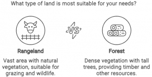
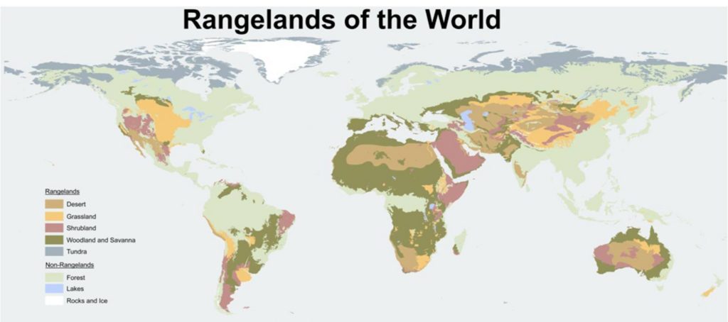
Rangeland, is any extensive area of land that is occupied by native herbaceous or shrubby vegetation which is grazed by domestic or wild herbivores.
It may include tallgrass prairies, steppes (shortgrass prairies), desert shrublands, shrub woodlands, savannas, chaparrals, and tundras.
These lands constitute 54% of all land cover, account for 1/6th of global food production, and represent nearly 1/3rd of the planet’s carbon reservoir.
World areas that are most acutely affected by Rangeland Degradation:
Central Asia, China, Mongolia: The replacement of government management with privatization and agricultural industrialization led to the abandonment of herders and reliance on insufficient natural resources, causing degradation.
North Africa and the Near East: Climate change is pushing pastoralists into poverty and degrading rangelands.
Sahel and West Africa: Conflict, power imbalances, and border issues have disrupted livestock mobility, leading to degradation.
South America: Climate change, deforestation from industrial agriculture, and land use conversion are primary drivers of degradation.
East Africa: Migration and forced displacement due to competing land uses are evicting pastoralists, causing degradation.
North America: Degradation of ancient grasslands and dry rangelands threatens biodiversity in ecosystems like tall-grass prairies and southern deserts.
Europe: Policies favoring industrial farming over pastoralism and misguided incentives are causing the abandonment and degradation of rangelands.
South Africa and Australia: Afforestation, mining, and land conversion are causing degradation and loss of rangelands.
How does it impact the Food chain?
Over two billion people, including small-scale herders, ranchers, and farmers, depend on healthy rangelands for their livelihoods, underscoring the critical link between rangeland health and food chain cycle.
Up to 50% of rangelands are degraded due to various factors including overuse, misuse, climate change, and biodiversity loss, posing a severe threat to food security.
The Economic significance of Rangelands:
Livestock Grazing and Agriculture: Rangelands are crucial for livestock production, providing natural forage for cattle, sheep, goats, and other herbivores. This grazing land supports the meat and dairy industries, which are vital to the global food supply and rural economies.
Eco-tourism and hunting: These areas support a wide range of wildlife, contributing to biodiversity and offering opportunities for eco-tourism and hunting, both of which generate significant income for local economies.
Ecosystem Services: Rangelands provide vital services like water filtration, carbon storage, and soil preservation, yielding economic advantages through climate regulation and conservation.
Income and employment opportunities: Harvesting these resources provides income and employment opportunities for rural populations. The economic contributions made by different countries are as follows:
Ethiopia: Livestock production from rangelands accounts for 19% of the country’s GDP.
India: Livestock from rangelands contributes 4% to the national GDP.
Brazil: As a major beef producer, Brazil generates one-third of its agribusiness GDP from cattle livestock, producing 16% of the world’s beef.
What is the innovative approach presented by the UNCCD Report?
The past estimates by UNCCD of degraded rangeland of roughly 25% are significantly underestimated, where the actual loss of rangeland’s health and productivity was potentially reaching up to 50%.
Conceptual Approach: The report outlines a new conceptual approach designed to help policymakers stabilize, restore, and manage rangelands more effectively.
This new approach is supported by detailed case studies from nearly every world region, which provide important lessons from both the successes and failures in rangeland management.
Core Recommendation – Protect Pastoralism: The report emphasizes the importance of protecting pastoralism a traditional, mobile way of life based on pasture-based livestock production as a key strategy for sustainable rangeland management.
Conclusion: Many countries like the U.S. and Canada makingare trying to reintroduce bison, an animal with significant cultural importance to indigenous peoples. This initiative aims to promote rangeland health and enhance food security.
Mains PYQ:
Q The process of desertification does not have climate boundaries. Justify with examples.(UPSC IAS/2020)
Wildlife authorities in Himachal Pradesh’s Lahaul & Spiti district have initiated surveys to estimate the population of Blue Sheep (bharal) and Himalayan Ibex (Tangor), vital prey species for the iconic snow leopard.
This move aims to assess the region’s biodiversity and promote conservation efforts.
About the Species Mentioned
Bharal (Blue Sheep)
Himalayan Ibex (Tangor)
Scientific Name
Pseudois nayaur
Capra sibirica hemalayanus
Genus
Pseudois
Capra
Distribution
India, Bhutan, China (Gansu, Ningxia, Sichuan, Tibet, Inner Mongolia), Myanmar, Nepal, Pakistan
Himalayan region of India, Pakistan, Tibet, Nepal
Features
Slate grey coat with bluish shine
Horns grow upwards, curve out, and then towards the back
Large curved horns with notches on the front
Light brown to reddish-brown coat, white belly, black and white markings on legs
Thick, woolly coat in winter, shed in early summer
Behavior
Active throughout the day, alternating between feeding and resting on grassy mountain slopes
Usually found in small herds, sometimes around 50 together;
Q) ‘Clean energy is the order of the day.’ Describe briefly India’s changing policy towards climate change in various international fora in the context of geopolitics. (UPSC CSE 2022)
Q) Describe the major outcomes of the 26th session of the Conference of the Parties (COP) to the United Nations Framework Convention on Climate Change (UNFCCC). What are the commitments made by India in this conference? (UPSC CSE 2021)
Prelims: Consider the following statements: (UPSC CSE 2016) 1. The International Solar Alliance was launched at the United National Climate Change Conference in 2015. 2. The Alliance includes all the member countries of the United Nations. Which of the statements given above is/are correct? (a) 1 only (b) 2 only (c) Both 1 and 2 (d) Neither 1 nor 2
Note4Students:
Prelims: Climate change; Policies and Programs in India
Mains: Climate change policies in India;
Mentor comment: India, as one of the most vulnerable countries to climate change, faces significant challenges due to rising temperatures, changing weather patterns, and environmental degradation. The impact of climate change is evident in the reduction of monsoon duration and rainfall levels, melting Himalayan glaciers, and rising sea levels threatening coastal regions. These changes pose risks to agriculture, food security, water availability, and overall environmental sustainability in the country. This article presents the reasons behind the relative lack of political focus on climate change in India and the potential implications for the country’s future.
Let’s learn.
–
Why in the News?
Our Indian politics is overshadowed by merely immediate concerns and political agendas while leaving behind the major challenges like Climate Change and addressing its impacts.
This absence stands out even more when we consider the urgent need for sustainable development amidst worldwide environmental challenges.
Current State of Climate Change in India
According to India’s first-ever Climate Change Assessment Report carried out in 2020, the country’s average temperature is expected to rise by 4.4°C by the end of 2100. A decline in monsoon rainfall since the 1950s has already been observed. A 2°C rise in global average temperatures will make India’s summer monsoon highly unpredictable. At 2.5°C warming, melting glaciers, and loss of snow cover are expected to threaten the stability and reliability of northern India’s glacier-fed rivers. Global sea level has risen about 8 inches in the last century, which is expected to nearly double in this century.
The Present Dilemma: Prioritization of Economic Growth
As a developing nation, India prioritizes economic growth and development as a means to alleviate poverty and improve the standard of living for its citizens.
This focus often leads to a trade-off between environmental protection and industrial expansion, with climate change considerations taking a lower priority in the political discourse.
Challenges associated with generating political will and public support for climate action:
Lack of Immediate Visibility: The effects of climate change are often gradually visible to the general public. This lack of immediate consequences makes it challenging for politicians to garner public support for climate action, as voters tend to prioritize issues that directly impact their daily lives.
Competing Priorities and Short-term Thinking: Indian politics is often characterized by a focus on short-term goals and immediate concerns, such as job creation, infrastructure development, and social welfare schemes. Climate change, with its long-term implications, struggles to gain traction in a political landscape dominated by these pressing issues.
Perceived Conflict with Development Agenda: Some politicians and policymakers view climate action as a hindrance to economic development, fearing that it may limit industrial growth and restrict access to energy resources. This perception creates a barrier to implementing comprehensive climate policies.
Lack of Awareness and Education: Despite growing global awareness of climate change, there is still a need for greater education and understanding of the issue among the general public and political leaders in India.
Government Policies to Address Climate ChangeInternational Solar Alliance (ISA):
India collaborates with solar energy-rich countries to promote solar energy utilization and reduce reliance on non-renewable energy sources. One Sun, One World, One Grid Project: This project seeks to provide energy (SDG 7 – affordable and clean energy) to around 140 countries through a common grid that transfers solar power. By promoting solar energy on a global scale, this initiative addresses energy challenges and supports sustainable development. Swachh Bharat Mission: It focuses on cleanliness and sanitation (SDG 6 – Clean Water and Sanitation) across urban and rural areas in India. By ensuring access to sanitation facilities and promoting cleanliness, this initiative contributes to environmental health and sustainability. COP26 Glasgow Summit Commitments: During the COP26 summit, India made significant commitments to combat climate change, including achieving net zero emissions by 2070, meeting 50% of energy requirements from renewable sources by 2030, reducing carbon emissions, increasing non-fossil energy capacity, and decreasing carbon intensity by 2030. (SDG 13 – mitigating climate change).The Climate Action Tracker gives India an overall rating of “Highly Insufficient” in its policies and actions tracking, based on 2030 projections. Recent Judicial Stance: M.K. Ranjitsinh and Others vs Union of India (March 2024): The Supreme Court of India ruled that the people of India have the right to be free from the adverse effects of climate change by drawing upon Article 21 and Article 14 of the Indian Constitution. Recent Legislations: Some important policies and laws covering the energy sector emerged, which included the National Electricity Plan 2023, the National Green Hydrogen Mission and the Energy Conservation (Amendment) Act, 2022.
The Way Forward: To elevate climate change as a priority in Indian politics, a multi-pronged approach is necessary:
Emphasizing the economic benefits of climate action: Highlighting the potential for green jobs, sustainable development, and long-term cost savings can help align climate action with economic interests.
Promoting public awareness and engagement: Investing in education campaigns and fostering grassroots movements can help raise awareness and generate public pressure for climate action.
Incorporating climate change into political manifestos: Encouraging political parties to include climate change as a key issue in their election manifestos can help mainstream the topic and ensure its prominence in the political discourse.
Fostering cross-party collaboration: Building consensus and cooperation across political parties on climate change can help ensure continuity and long-term commitment to climate action, regardless of which party is in power.
It was formed as part of the Environmental Protocol (Madrid Protocol, 1991) to the Antarctic Treaty, which came into force in 1998.
Aim: To advice and formulate recommendations on environmental protection measures in the Antarctic region.
Composition: It consists of representatives from the consultative parties to the Antarctic Treaty, which includes countries active in Antarctic research and governance.
Functions:
Environmental Impact Assessment (EIA): The CEP oversees the EIA process for activities conducted in the Antarctic region to ensure they minimize environmental impacts.
Site Inspections: It conducts inspections of Antarctic facilities and activities to verify compliance with environmental regulations.
Scientific Research: The CEP promotes scientific research on Antarctic ecosystems and advises on measures to conserve biodiversity.
Waste Management: It develops guidelines for waste management and pollution prevention in the Antarctic, aiming to minimize human impact on the environment.
Policy Formulation: The CEP formulates policies and guidelines related to environmental protection in the Antarctic Treaty.
Back2Basics: Madrid Protocol, 1991
The Madrid Protocol refers to the Protocol on Environmental Protection to the Antarctic Treaty.
It is an international agreement that was adopted in 1991 and entered into force in 1998.
Key aspects of the Madrid Protocol include:
Environmental Principles: The Protocol outlines principles for the protection of the Antarctic environment, including the conservation of living resources, the prevention of pollution, and the protection of wilderness and scientific values.
Designation of Protected Areas: It designates certain areas of Antarctica as specially protected areas (SPAs) and sites of special scientific interest (SSSI), where specific environmental protection measures apply to safeguard their ecological, scientific, and aesthetic values.
Waste Management: It establishes guidelines and regulations for waste management and pollution prevention in Antarctica, aiming to minimize human impact on the environment and prevent pollution of the Antarctic ecosystem.
Prohibition of Mineral Resource Activities: The Protocol prohibits all mineral resource activities, including exploration and exploitation, in Antarctica. This provision aims to preserve the pristine and fragile nature of the Antarctic environment and prevent the potential environmental damage associated with mineral extraction.
Consultative Mechanisms: The Protocol establishes mechanisms for consultation and cooperation. This includes the CEP, which provides advice and recommendations on environmental matters to the Antarctic Treaty Consultative Meeting (ATCM).
PYQs:
[2021] How do the melting of the Arctic ice and glaciers of the Antarctic differently affect the weather patterns and human activities on the Earth? Explain.
[2011] The formation of ozone hole in the Antarctic region has been a cause of concern. What could be the reason for the formation of this hole?
(a) Presence of prominent tropospheric turbulence; and inflow of chlorofluorocarbons.
(b) Presence of prominent polar front and stratospheric clouds; and inflow of chlorofluorocarbons.
(c) Absence of polar front and stratospheric clouds; and inflow of methane and chlorofluorocarbons.
(d) Increased temperature at polar region due to global warming.
The National Centre for Polar and Ocean Research, Goa, through the Ministry of Earth Sciences (MoES), has organised the meeting, which will be attended by the 56 member countries of the Antarctic Treaty.
What is the Antarctic Treaty Consultative Meeting (ATCM)?
ATCM is the primary forum for discussing and coordinating activities related to the Antarctic Treaty System.
It was established under the Antarctic Treaty, which was signed in 1959 and entered into force in 1961.
It serves as the annual meeting of the parties to the Antarctic Treaty, known as Consultative Parties.
The ATCM adopts legally binding agreements, known as Antarctic Treaty Measures (ATMs), as well as non-binding recommendations on various matters.
Decisions within the ATCM are made by consensus among the Consultative Parties.
The ATCM established the Committee for Environmental Protection (CEP) as a subsidiary body to provide advice and recommendations on environmental matters.
India had last hosted the ATCM in New Delhi in 2007.
India’s Agenda at ATCM 46
During the Kochi meet, India will table its plan to construct Maitri II before the members.
Any new construction or initiative in Antarctica requires the ATCM’s approval.
About Antarctic Treaty
Details
Signing and Entry into Force
Signed on December 1, 1959 at Washington DC.
Entered into force on June 23, 1961.
12 Initial Countries: Argentina, Australia, Belgium, Chile, France, Japan, New Zealand, Norway, South Africa, the USSR, the UK, and the US.
Objective
Ensure Antarctica remains exclusively for peaceful purposes, free from international discord.
Key Provisions
Art. I: Antarctica shall be used for peaceful purposes only
Art. II: Freedom of scientific investigation in Antarctica and cooperation
Art. III: Scientific observations and results from Antarctica shall be exchanged and made freely available
Antarctic Treaty Secretariat (ATS), established in 2004, serves as the administrative hub for the Antarctic Treaty System.
Annual Antarctic Treaty Consultative Meetings (ATCM) where member states discuss treaty implementation and cooperation.
Environmental Protection
Promotes protection of the Antarctic environment.
Prohibits activities causing pollution or environmental damage
Mineral Resource Exploitation
Bans mining activities until at least 2048.
Requires consensus for any review or modification
Membership
54 parties as of 2024.
29 Consultative Parties actively participate in decision-making.
25 Non-Consultative Parties.
India ratified the treaty in 1983.
Madrid Protocol
Adopted in 1991.
Entered into force in 1998.
Strengthens environmental protection measures in Antarctic.
India in Antarctica
1. Governance:
Since 1983, India has been a consultative party to the Antarctic Treaty.
Of the 56 nations that are part of the Antarctic Treaty, 29 have consultative party status.
In this capacity, India votes and participates in all key decision-making processes regarding Antarctica.
India has undertaken scientific research in Antarctica since 1981.
2. Scientific Expeditions:
The first Indian Antarctica research station, Dakshin Gangotri, was set up in 1983, some 2,500 km from the South Pole in Queen Maud Land. The station operated till 1990.
In 1989, India set up its second Antarctica research station, Maitri, in the Schirmacher Oasis, a 3-km wide ice-free plateau with over 100 freshwater lakes.
It is still operational and located about 5 km from Russia’s Novolazarevskaya Station, and 90 km from Dakshin Gangotri.
In 2012, India inaugurated Bharati, its third Antarctica research station, located around 3,000 km east of Maitri, on the Prydz Bay coast.
Although the station focuses on oceanographic and geologic study, the Indian Space Research Organisation (ISRO) utilises it for receiving Indian Remote sensing Satellite (IRS) data.
India plans to open a new station, Maitri II, a few kilometres from the ageing Maitri station. Operations are set to begin by 2029.
In 2022, India enacted the Antarctic Act, reaffirming its commitment to the Antarctic Treaty.
About the National Centre for Polar and Ocean Research (NCPOR)
NCPOR is an Indian research and development institution, situated in Vasco da Gama, Goa.
It is an autonomous institution of the Department of the Ministry of Earth Sciences, established in 1998.
It is responsible for scientific and strategic endeavors in the Polar Regions (Arctic and Antarctic), the Himalayas, and the Southern Ocean.
PYQ:
[2015] The term ‘IndARC’ sometimes seen in the news is the name of
(a) An indigenously developed radar system inducted into Indian Defence.
(b) India’s satellite to provide services to the countries of Indian Ocean Rim.
(c) A scientific establishment set up by India in Antarctic region.
(d) India’s underwater observatory to scientifically study the Arctic region.
The World Bank report, titled “Water for Shared Prosperity,” was released at the 10th World Water Forum in Bali, Indonesia.
It underscores the widening gap in access to water resources and services, exacerbated by factors like population growth, urbanization, and climate change.
Water for Shared Prosperity: Key Highlights of the Report
In 2022, 2.2 billion people lacked access to safely managed drinking water services, while 3.5 billion lacked access to safely managed sanitation.
Over 800 million people globally are at high risk of drought, with double that number living in flood-prone areas.
Low-income countries have seen a regression in access to safe drinking water, with an additional 197 million people lacking access since 2000.
Rural-urban access gaps in low-income countries have remained largely unchanged over the last two decades.
Hotspots in regions like the Sahel, Southeastern Africa, and South and Central Asia experience the highest water stress.
The Democratic Republic of the Congo holds over half of Africa’s total water resources.
About World Water Forum:
It is a large-scale international event that focuses on the discussion and development of solutionsto global water-related challenges.
It is held every three years. The first forum took place in took place in Marrakesh, Morocco in March 1997.
It is organized by the World Water Council, an international organization.
It brings together stakeholders from various sectors including governments, organizations, businesses, and academia to promote awareness, build political commitment, and trigger action on critical water issues at all levels.
What is the World Water Council (WWC)?
The World Water Council was founded in 1996.
The idea for the WWC emerged from discussions during the International Water and Sanitation Congress & Exhibition in 1994 and the subsequent Ministerial Conference on Drinking Water and Environmental Sanitation in 1996.
WWC’s activities focus on targets related to SDG 6 (Clean Water and Sanitation), among others.
The Council was established by renowned water specialists and international organizations, including academic institutions, private companies, governments, and NGOs etc.
Objective: The primary aim of the Council is to raise awareness about critical water issues at all levels, including the highest decision-making levels, to facilitate efficient conservation, protection, development, planning, management, and use of water resources globally.
Membership: The WWC boasts a diverse membership base comprising over 300 member organizations in approximately 50 countries.
Key Functions and Contributions:
World Water Forums: It is the world’s largest event on water and gathers participants from various sectors to discuss and collaborate on water issues.
Policy Influence: The WWC works to influence policy by facilitating discussions among political and economic decision-makers.
Research and Advocacy: Through its publications, policy papers, and strategic projects, the WWC fosters greater understanding and awareness of water issues.
PYQ:
[2016] The effective management of land and water resources will drastically reduce the human miseries. Explain.
[2012] If National Water Mission is properly and completely implemented, how will it impact the country?
Part of the water needs of urban areas will be met through recycling of waste water.
The water requirement of coastal cities with inadequate alternative sources of water will be met by adopting appropriate technologies that allow for use of ocean water.
All the rivers of Himalayan origin will be linked to the rivers of peninsular India.
The expenses incurred by farmers for digging bore wells and for installing motors and pump sets to draw groundwater will be completely reimbursed by the Government.
Select the correct answer using the codes given below:
The International Organization for Migration (IOM) has recently launched the World Migration Report 2024.
Back2Basics: International Organization for Migration (IOM)
Details
About
Originated in 1951 as the Provisional Intergovernmental Committee for the Movement of Migrants from Europe (PICMME) after World War II’s upheavals.
In 2016, IOM agreed with the United Nations, becoming a related organization.
Headquarters
Geneva, Switzerland
Members
Currently has 175 Member States and 8 states with Observer status.
India became an IOM Member State on 18th June 2008.
Key Highlights of the Report:
Climate Change Impacts on Migration
The report highlights a significant increase in global migration due to environmental impacts and climate change, with more than 216 million people projected to be on the move within their countries by 2050.
Migration is being used as a strategy to cope with and adapt to the adverse effects of climate change, although its effectiveness varies based on individual circumstances and active involvement of migrants.
Specific Regional Insights:
Africa:
Climate change has led to severe weather changes, including decreased rainfall and increased temperatures in North Africa, contributing to migration.
Countries like Libya, Algeria, and Morocco have seen migration due to reduced rainfall and increased drought conditions.
Asia:
In South Asia, particularly Pakistan and Bangladesh, extreme weather events like floods have led to substantial displacement.
The 2022 floods in Pakistan resulted in nearly 1.7 million displacements and in Bangladesh, record-breaking floods in 2022 triggered over 1.5 million displacements.
In India, strong influence of climate impacts on internal migration from Rajasthan, Uttar Pradesh and Madhya Pradesh.
Remittances Inflows in India
According to the Report, India has consistently been the top recipient of remittances globally. In 2022, India received a record-breaking $111.22 billion in remittances.
Remittance Inflows:
India is way ahead of its closely ranked peers Mexico ($61.1 billion), China ($51 billion), Philippines ($38.05 billion) and France ($30.04 billion).
This is the first time any country has crossed the USD 100 billion mark in remittance inflows.
The largest contributions to India’s remittances come from the UAE, USA, and Saudi Arabia, reflecting the extensive Indian diaspora in these regions.
Migration Statistics:
With 18 million international migrants residing primarily in the UAE, USA, and Saudi Arabia, India hosts the world’s largest number of international migrants.
This large diaspora plays a crucial role in the economic linkage between India and these countries through remittances.
India came in 13th as the destination country for immigrants, with 4.48 million.
PYQ:
[2015] Discuss the changes in the trends of labour migration within and outside India in the last four decades.
At the upcoming COP29 in Baku in November this year, Azerbaijan, the primary discussion will center on the New Collective Quantitative Goal (NCQG) for climate finance.
Recent Climate Conferences and Decisions:
2022 Sharm el-Sheikh Conference: A Loss and Damage Fund was established to assist developing countries in recovering from climate disasters.
Dubai Conference: The focus was on the Global Stocktake (GST) of climate actions, acknowledging the need to transition away from fossil fuels and tripling global renewable energy capacity by 2030.
What is the New Collective Quantitative Goal (NCQG)?
All the parties of the Paris Agreement participate and review the implementation of the Agreement and make decisions. CMA is held once a year.
This goal will start with a target of at least $100 billion per year, focusing on the requirements and priorities of developing countries.
It will replace the previous commitment of USD 100 billion per year that developed nations had pledged in 2009 but never delivered.
NCQG:A timeline
In 2009: The developed countries agreed to provide approximately $30 billion in ‘new and additional’ financial resources to developing countries from 2010 to 2012.
Additionally, these countries committed to collectively raising $100 billion annually by 2020 to support climate action in developing countries.
In 2015: It was decided to continue this collective goal of mobilizing $100 billion yearly by developed countries up to 2025.
A new climate finance target is to be set before 2025, maintaining at least $100 billion per year and considering the needs and priorities of developing countries. This is referred to as the NCQG or the new goal for post-2025.
Financial Requirements for Effective Climate Action:
Current Funding Gaps: The scale of annual climate finance has consistently fallen short of the $100 billion promised by developed countries.
Projected Needs: Developing countries require about $6 trillion annually until 2030 to implement their climate action plans, according to a 2021 UN Climate Change report. An updated version of this report is expected to raise this figure even higher.
Global Transition Costs: A global transition to a low-carbon economy is estimated to require about $4-6 trillion every year until 2050.
Renewable Energy Expansion: Tripling renewable energy capacity, as agreed in Dubai, is estimated to cost $30 trillion until 2030, per the International Renewable Energy Association (IRENA).
Prospects for Meeting Financial Targets:
Realistic Expectations: Discussions are ongoing, with India suggesting a target of at least $1 trillion per year, primarily through grants and concessional finance.
Challenges: Developed countries have historically fallen short of even lesser goals, and achieving trillions in finance is seen as ambitious.
Back2Basics: GlobalInitiatives for Financing Climate Action
Established
Purpose
How it Works
Green Climate Fund (GCF)
2010
To support developing countries in adaptation and mitigation to counter climate change.
Mobilizes funding from developed to developing countries to reduce greenhouse gas emissions and enhance climate resilience. Operates under the UNFCCC financial mechanism.
Global Environment Facility (GEF)
1991
To tackle global environmental issues while supporting national sustainable development.
Provides grants for projects related to environmental conventions (biodiversity, climate change, international waters, land degradation, ozone layer, organic pollutants). Functions as a financial mechanism for multiple conventions including the UNFCCC.
Climate Investment Funds (CIF)
2008
To bridge funding and learning gaps for cleaner technology transformations.
Offers scaled-up financing to middle-income countries to initiate cleaner technology transformations. Includes funds like the Clean Technology Fund (CTF) and the Strategic Climate Fund (SCF).
Adaptation Fund
2001
To finance concrete adaptation projects in developing countries party to the Kyoto Protocol.
Financed by a share of proceeds from CDM project activities, it supports concrete adaptation projects in vulnerable communities.
Special Climate Change Fund (SCCF)
2001
To finance projects in adaptation, technology transfer, and various management sectors.
Managed by the GEF, supports projects in sectors not directly funded through other funds such as energy, transport, and waste management.
Least Developed Countries Fund (LDCF)
2001
To support the least developed countries (LDCs) in their climate change initiatives.
Finances the preparation and implementation of National Adaptation Programmes of Action (NAPAs) which identify priority activities for LDCs to adapt to climate change.
Carbon Pricing Mechanisms
NA
To internalize the cost of GHG emissions, incentivizing emission reductions.
Involves setting a price on carbon emissions either through carbon taxes or emissions trading schemes (ETS), encouraging businesses to reduce emissions.
To enhance cooperation to achieve NDC goals under the Paris Agreement.
Facilitates technical and financial support to help countries implement and enhance their NDC commitments for reducing emissions.
PYQ:
[2016] With reference to the Agreement at the UNFCCC Meeting in Paris in 2015, which of the following statements is/are correct?
The Agreement was signed by all the member countries of the UN, and it will go into effect in 2017.
The Agreement aims to limit the greenhouse gas emissions so that the rise in average global temperature by the end of this century does not exceed 2ºC or even 1.5ºC above pre-industrial levels.
Developed countries acknowledged their historical responsibility in global warming and committed to donate $ 1000 billion a year from 2020 to help developing countries to cope with climate change.
Select the correct answer using the code given below:
(a) 1 and 3 only
(b) 2 only
(c) 2 and 3 only
(d) 1, 2 and 3
Astronomers have identified a new Earth-sized exoplanet, named Speculoos-3b, orbiting an ultracool red dwarf star.
Back2Basics: Red Dwarf Star
A red dwarf is the most common type of star in the Milky Way galaxy.
However, due to their low luminosity, individual red dwarfs cannot be easily observed.
Proxima Centauri, the star nearest to the Sun, is a red dwarf, as are fifty of the sixty nearest stars.
According to some estimates, red dwarfs make up three-quarters of the fusing stars in the Milky Way.
About Speculoos-3b
Speculoos-3b is an Earth-sized exoplanet recently discovered orbiting an ultracool dwarf star.
It was discovered by a team of astronomers led by Michael Gillon from the University of Liege in Belgium.
It is located approximately 55 light-years away from Earth.
Due to its short orbital period, Speculoos-3b receives almost ten times more energy per second than Earth does from the Sun.
SPECULOOS Project
Project Overview: The discovery was made under the SPECULOOS project, aimed at exploring exoplanets around ultra-cool dwarf stars.
The SPECULOOS Southern Observatory is a project carried out by the University of Liège (Belgium) and the Cavendish Laboratory in Cambridge (United Kingdom)
Astrophysical Significance of the Discovery
Prevalence of Ultracool Dwarfs: Ultracool dwarf stars, like the host of Speculoos-3b, constitute about 70% of all stars in our galaxy and are known for their longevity, surviving up to 100 billion years.
Importance for Life’s Potential: The extended lifespan of these stars provides a stable environment that could potentially support the development of life on orbiting planets.
PYQ:
[2015] The term ‘Goldilocks Zone’ is often seen in the news in the context of:
(a) the limits of habitable zone above the surface of the Earth
(b) regions inside the Earth where shale gas is available
(c) search for the Earth-like planets in outer space
(d) search for meteorites containing precious metals
A rare hemi-parasitic terrestrial plant has been found in Phawngpui National Park of Mizoram.
It has been named ‘Phtheirospermum Lushaiorum’ after the Lushai tribe of Mizoram, honoring their commitment to biodiversity conservation.
About Lushai Tribe
Lushai is another tribe under the Kuki-chin group(racially from Mongolia) of tribes.
They are commonly known as Mizos.
In Tripura there are 5,384 persons (as per 2011 Census).
Occupation: They mostly reside in the Jampui Hills area of Tripura and have Jhum Cultivation and hunting of wild animals as their main occupation.
Culture and belief:
converted to Christianity and still follow Christianity as their religion.
Their Cheraw Dance (Bamboo Dance) is quiet famous.
About Phtheirospermum Lushaiorum
This plant lacks a fully developed root system and taps into the sap of host plants through specialized structures known as haustoria.
Despite its parasitic nature, it contains chlorophyll and can produce its food, showing some independence from its host.
It flowers from July to September, with fruit production occurring from August to October.
The plant grows near a popular trekking route in Phawngpui National Park, facing threats from both anthropogenic activities and natural factors.
Back2Basics: Phawngpui National Park
Also known as Blue Mountain National Park, it is one of the two national parks in Mizoram (the other being Murlen NP).
Geographical location:
Close to the border with Burma (Myanmar).
The park overlooks the Chhimtuipui River, which flows toward Burma.
The geography of Phawngpui is characterized by its cloud-covered mountain area, which gives it a distinctive blue appearance from a distance.
Flora and Fauna:
Bird species:Blyth’s tragopan, falcons, sunbirds, dark-rumped swifts, and the Mizoram state bird, Mrs. Hume’s pheasant.
Mammals: Mountain goat, slow loris, tiger, leopard, leopard cat, serow, goral, Asiatic black bear, stump-tailed macaque, and capped langur.
Flora: Grassy meadows, orchids, rhododendrons, and bamboo groves.
PYQ:
[2016] Recently, our scientists have discovered a new and distinct species of banana plant which attains a height of about 11 meters and has orange-coloured fruit pulp. In which part of India has it been discovered?