💥Join UPSC 2027,2028 Mentorship (July Batch) + XFactor Notes & Microthemes PDF

Subject: Geographical Features

  • Typhoon Gaemi 

    Why in the News?

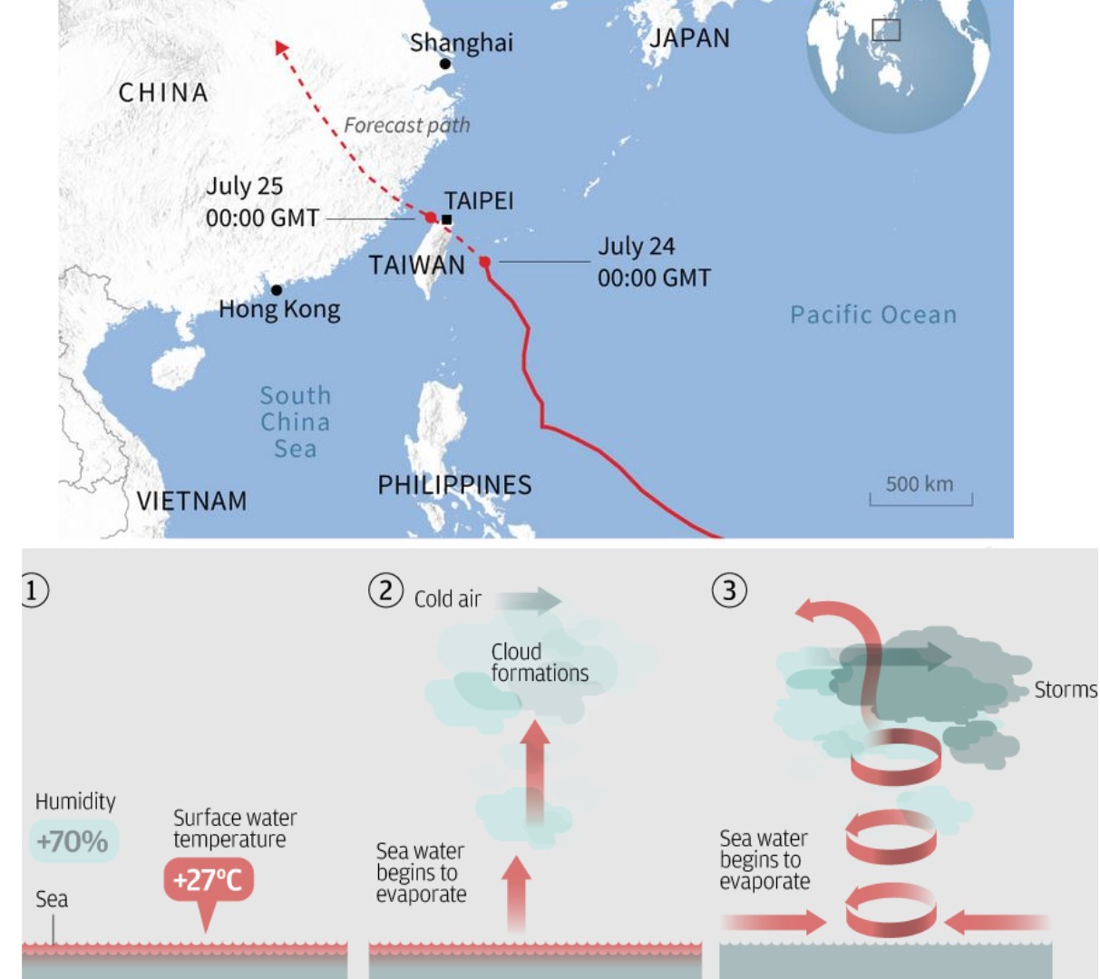
    After making landfall in the Philippines, Typhoon Gaemi is heading towards Taiwan.

    What is a Typhoon?

    • A typhoon is a mature tropical cyclone that forms in the Northwest Pacific Ocean, primarily between 100°E and 180°E.
    • It is characterised by strong winds, and heavy rain, and can cause significant damage due to high wind speeds, storm surges, and flooding.

    Factors causing its formation:

    • It needs sustained ocean temperatures of 26.5°C or higher.
    • High moisture content in the mid-troposphere.
    • Presence of the Coriolis force to initiate rotation.
    • Minimal vertical wind shear to allow for storm growth.
    • Atmospheric instability to promote rising motion and thunderstorm activity.
    • An initial low-pressure area or tropical wave to trigger development.
      • Formation Regions: Northwest Pacific Ocean in areas east of the Philippines, southeast of Japan, and near Taiwan; South China Sea and in Western North Pacific near the Mariana Islands and Guam.
    Note: Typhoons do not form in the South Atlantic Ocean and the southeastern Pacific Ocean because of cooler sea surface temperatures and higher wind shear in those regions.


    PYQ:

    [2015] In the South Atlantic and South-Eastern Pacific regions in tropical latitudes, cyclone does not originate. What is the reason?

    (a) Sea surface temperatures are low
    (b) Inter-Tropical Convergence Zone seldom occurs
    (c) Coriolis force is too weak
    (d) Absence of land in those regions

  • Last Universal Common Ancestor (LUCA)

    Why in the News?

    • The origin of life on Earth remains one of the world’s most enduring mysteries.
      • Numerous competing theories exist, but none have conclusive proof.
      • A significant concept in understanding the origin of life is the Last Universal Common Ancestor (LUCA).

    What is the Last Universal Common Ancestor (LUCA)?

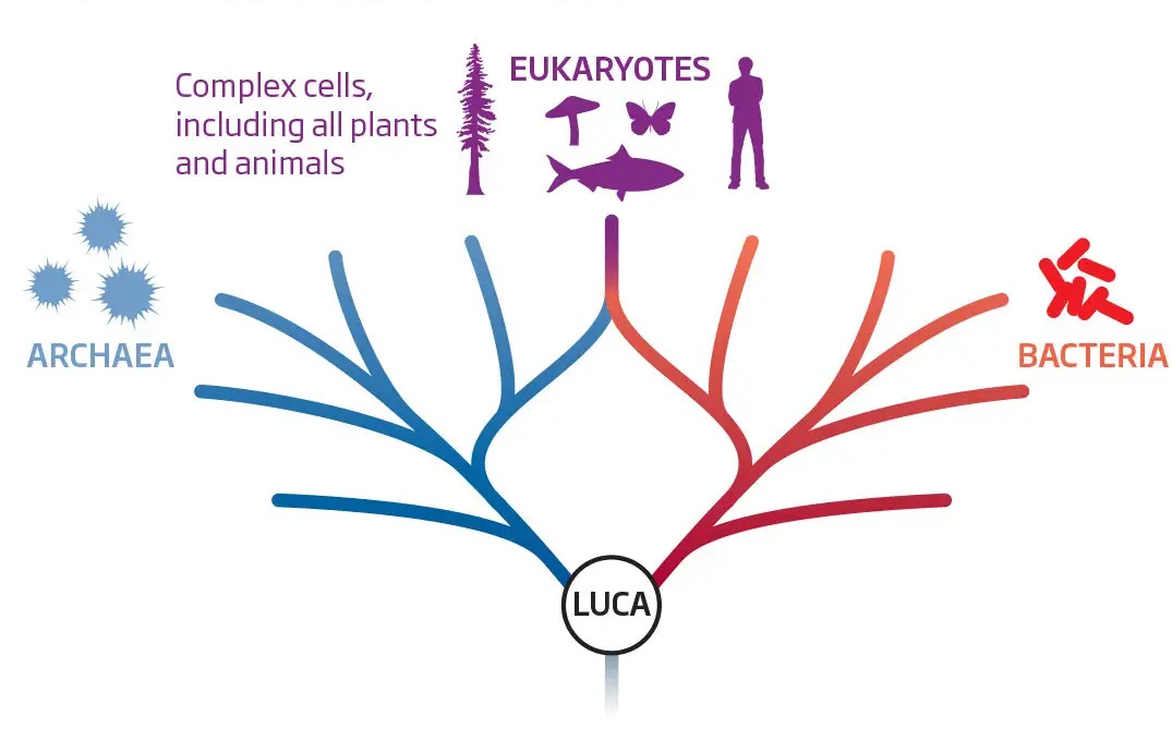
    • Researchers believe that all life forms— the Bacteria, the Archaea, and the Eukarya —originated from a single cell known as the last universal common ancestor (LUCA).
    • It is suggested to have been a “cellular organism that had a lipid bilayer and used DNA, RNA, and protein“.
    • There is a lack of clarity about direct fossil evidence of LUCA.
    • However, the shared features of modern genomes provide significant insights into this ancient ancestor.

    LUCA and the Molecular Clock:  

    • The molecular clock theory was proposed by molecular biologist Emile Zuckerkandl and biochemist Linus Pauling in the 1960s and later refined by biologist Motoo Kimura.
    • The theory allows scientists to reconstruct the evolutionary timeline.
    • According to the theory, the rate at which mutations are added or removed from a population’s genome is proportional to the rate of acquiring new mutations, which is constant.
    • By calibrating the molecular clock with known events, such as the emergence of the first mammals or the age of certain fossils, researchers can estimate the time between evolutionary events.

    Recent Research Findings on LUCA’s Age and Genome

    • Researchers at the University of Bristol and Exeter estimate that LUCA originated around 4.2 billion years ago, nearly 1 billion years earlier than previously thought. 
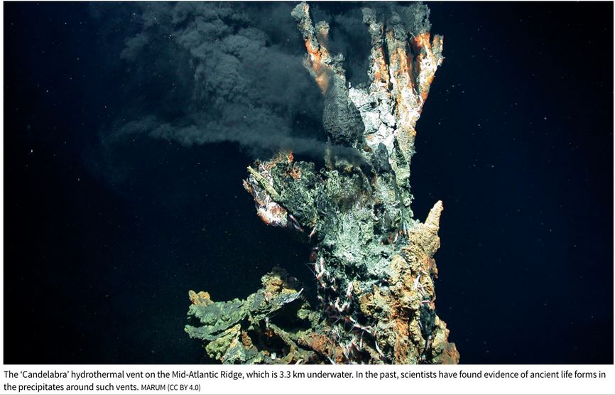
      • They obtained evidence from the 3.3 km deep Candelabra’ hydrothermal vent on the Mid-Atlantic Ridge.
    • LUCA had a small genome of about 2.5 million bases encoding 2,600 proteins, sufficient for survival in a unique niche.
    • Its metabolites may have created a secondary ecosystem for other microbes.
    • The presence of immunity genes in LUCA suggests it had to defend against viruses.

    Evidence Verification using Miller-Urey Experiment

    • In 1952, Stanley Miller and Harold Urey conducted an experiment at the University of Chicago, simulating lightning strikes on a mixture of methane, ammonia, and water, which resulted in the formation of amino acids.
    • This demonstrated that complex organic compounds could arise from inorganic compounds under the right conditions.

    Which is older: LUCA or fossils?

    • LUCA’s estimated origin at 4.2 billion years predates the earliest fossil records by almost 1 billion years.
    • Fossil records from the Pilbara Craton in Australia suggest life emerged around 3.4 billion years ago, but the study pushes this date back.

    Alternative Theories: 

    (1) Extraterrestrial Origin

    • Another prominent theory suggests that meteorites from space could have brought the building blocks of life to Earth.
    • This theory is supported by various discoveries.
    • In August 2019, French and Italian scientists reported finding 3.3 billion-year-old extraterrestrial organic material.
    • Japan’s Hayabusa 2 mission to the asteroid Ryugu detected more than 20 amino acids, further supporting the possibility of an extraterrestrial origin for the building blocks of life.

    (2) Oparin-Haldane Hypothesis

    • In the 1920s, Alexander Oparin and J.B.S. Haldane independently proposed theories regarding the origin of life.
    • They suggested that life originated from a “primordial soup” in a prebiotic environment on the young Earth.
    • This concept is now known as the Oparin-Haldane hypothesis.


    PYQ:

    [2012] Which one of the following sets of elements was primarily responsible for the origin of life on the Earth?

    (a) Hydrogen, Oxygen, Sodium

    (b) Carbon, Hydrogen, Nitrogen

    (c) Oxygen, Calcium, Phosphorus

    (d) Carbon, Hydrogen, Potassium

  • What is Aphelion?

    Why in the News?

    Early on July 5, the Earth reached aphelion, its farthest distance from the sun in our year-long journey around our nearest star.

    What is Aphelion? 

    • Aphelion is a term used in astronomy to denote the point in the orbit of a planet or celestial body where it is farthest from the Sun. 
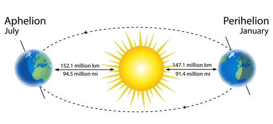
    • The Earth’s orbit around the Sun is not a perfect circle but rather an ellipse, with the Sun situated at one of the two foci of the ellipse. 
    • Aphelion marks the moment when Earth is at its maximum distance from the Sun along this elliptical path.
    • The concept of aphelion was crucial in Johannes Kepler‘s formulation of his laws of planetary motion during the 17th century.

    How far is the Earth from the Sun at aphelion? 

    • At aphelion, which occurs around July 4th– 5th each year, the Earth is approximately 152.1 million kilometers (about 94.5 million miles) away from the Sun. 
    • This distance is about 3.3% greater than its average distance from the Sun, known as its semi-major axis, which is about 147.1 million kilometers.

    Does aphelion affect temperatures on Earth? 

    • Aphelion has a slight effect on temperatures on Earth, but its impact is minimal compared to other factors such as axial tilt and atmospheric circulation patterns. 
    • Despite being farther from the Sun during aphelion, the Earth’s tilt towards the Sun during the northern hemisphere’s summer results in warmer temperatures for that region. 
    • This phenomenon is primarily responsible for the seasons on Earth.

    What would happen if there were no aphelion? 

    • If Earth’s orbit were perfectly circular, without aphelion or perihelion (the closest point to the Sun), the distance between Earth and the Sun would remain constant throughout the year. 
    • This scenario would result in less variation in seasonal temperatures between the northern and southern hemispheres. 
    • The distinct seasons that we experience today, which are essential for ecological diversity and agricultural cycles, would be significantly altered.

    PYQ:

    [2013] Variations in the length of daytime and night time from season to season are due to-

    (a) The earth’s rotation on its axis

    (b) The earth’s revolution round the sun in an elliptical manner

    (c) Latitudinal position of the place

    (d) Revolution of the earth on a tilted axis

  • What are hurricanes, their types?    

    Why in the news?

    Due to Hurricane Beryl sweeping through the Windward Islands, the Indian Men’s cricket team, victorious in the T20 World Cup, finds itself stranded in Barbados.

    What do we know about Hurricane Beryl?

    • Early Category 4 Storm: Hurricane Beryl is the earliest category 4 storm of the Atlantic hurricane season, sustaining winds of at least 130 miles per hour (209 kilometres per hour).
    • Location and Impact: It is currently affecting the Windward Islands in the southern part of the Lesser Antilles, including Barbados, Grenada, and Trinidad and Tobago.
    • Forecast: The National Hurricane Centre has issued warnings for life-threatening winds and storm surges in the affected islands, with the potential for violent winds and flash flooding.
    • Preparations: Local authorities in Barbados have suspended school classes and taken other precautions, such as shutting down the water supply, in anticipation of the hurricane’s impact.
    • Historical Context: Hurricane Beryl is noted as the strongest storm to impact the Windward Islands since Hurricane Ivan in September 2004.

    What are hurricanes and how do they form?

    • Formation: Hurricanes form over warm ocean waters near the equator where warm, moist air rises from the ocean’s surface, creating low air pressure.
    • Fuel: They are fueled by the heat and moisture evaporating from the ocean, forming clouds and spinning due to the Earth’s rotation.
    • Eye Formation: As the storm system intensifies, an eye forms at its centre, with storms rotating counterclockwise north of the equator and clockwise south of it.
    • Impact of Warming World: Warmer sea surface temperatures due to climate change may lead to slower decay of hurricanes upon landfall, potentially increasing their severity.

    Are hurricanes becoming more severe now?

    • Research Findings: Studies suggest that warmer sea surface temperatures contribute to the slower decay of hurricanes, potentially prolonging their destructive impacts inland.
    • Record-Breaking Seasons: The 2020 Atlantic Hurricane season has seen a record number of named storms, indicating a trend towards more frequent and intense hurricane activity.

    What is the difference between a hurricane and a tropical storm?

    • No Fundamental Difference: Hurricanes, typhoons, and cyclones are all types of tropical cyclones, named differently based on their location:
    • Hurricanes: Form over the Atlantic Ocean and the eastern Pacific Ocean.
    • Typhoons: Form in the Northwest Pacific Ocean.
    • Cyclones: Form in the Bay of Bengal and the Arabian Sea.
    • Naming Conventions: The different names signify regional differences but refer to the same meteorological phenomenon of tropical cyclones.

    Way forward: 

    • Implementation of Advanced Forecasting Technologies: Invest in state-of-the-art meteorological tools and satellite technology to enhance the accuracy and lead time of hurricane forecasts.
    • Community Preparedness Programs: Establish comprehensive community outreach programs to educate residents about hurricane risks, evacuation procedures, and emergency shelter locations.

    Mains PYQ:

    Q Discuss the meaning of colour-coded weather warnings for cyclone prone areas given by India Meteorological Department. (UPSC IAS/2014)

  • In news: Shyok River

    Why in the News?

    Five soldiers lost their lives when a tank was drowned away by powerful water currents in the Shyok River during a military training exercise in Ladakh.

    About Shyok River

    • The Shyok River is a significant river flowing through the Ladakh region of India and the Gilgit-Baltistan region of Pakistan.
    • It is a tributary of the Indus River and is known for its length and the rugged terrain it traverses.
    • The Shyok River spans approximately 550 kilometres in length.
    • It has a drainage basin covering parts of both India and Pakistan, making it an essential water source for the regions it traverses.

    Source and Course:

    • The river originates from the Rimo Glacier, located to the southeast of the Karakoram Pass.
    • It flows northwest to enter the Nubra Valley in Ladakh, a region known for its picturesque landscapes and sand dunes.
    • The river then turns southwest and flows through the disputed region of Gilgit-Baltistan, eventually joins the Indus River near Skardu.

    Tributaries:

    • The Shyok River has several tributaries, the most notable being the Nubra River, which flows through the Nubra Valley.
    • Other significant tributaries include the Saltoro River, originating from the Siachen Glacier region.

    Cultural and Historical Significance:

    • The river flows through that have been part of ancient trade routes between Central Asia and South Asia.
    • The Nubra Valley, through which the Shyok flows, is also known for its ancient monasteries and the Bactrian camels, which were used for trade along the Silk Route.

    Geographical significance of Shyok River 

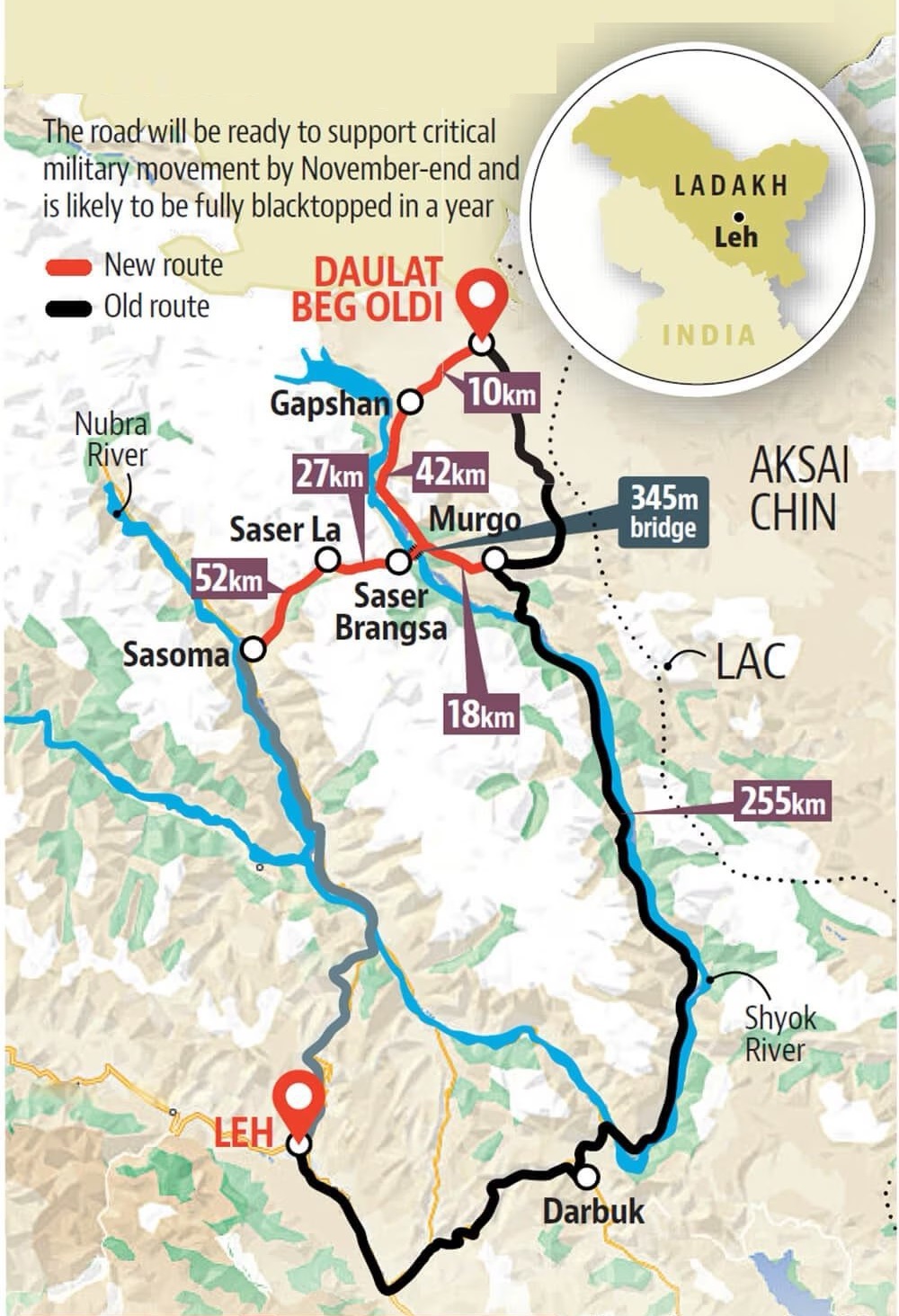
    • Strategic Location: The Shyok River flows through the Ladakh region of India and serves as a vital geographical feature due to its proximity to the Line of Actual Control (LAC) between India and China. Its strategic location influences military deployments and infrastructure development in the region, particularly in the context of border disputes and security concerns.
    • Glacial Melt and Water Resources: Originating from the Rimo Glacier and fed by numerous tributaries, the Shyok River contributes significantly to the water resources of the region. Its flow is crucial for agriculture, hydroelectric power generation, and sustenance of local ecosystems, impacting the livelihoods and socio-economic activities of communities along its banks.

    PYQ:

    [2020] Siachen Glacier is situated to the

    (a) East of Aksai Chin

    (b) East of Leh

    (c) North of Gilgit

    (d) North of Nubra Valley

  • Read the rocks to improve India’s geological literacy


    PYQ Relevance: 

    Q Safeguarding the Indian art heritage is the need of the moment. Comment (10) (UPSC IAS/2018)

    Q Do you agree that regionalism in India appears to be a consequence of rising cultural assertiveness? Argue. (UPSC IAS/2020)

    Mentors’ comment: India, with its landscapes ranging from the world’s highest peaks to low-lying coastal plains, showcases a diverse morphology that has evolved over billions of years. Numerous locations feature a variety of rocks, minerals, and distinctive fossil assemblages. These geological features and landscapes reveal spectacular ‘origin’ stories based on scientific interpretations rather than mythology. India’s tumultuous geological past is etched in its rocks and terrains and should be regarded as part of our non-cultural heritage. The country offers many such examples. Geo-heritage sites serve as educational spaces where people can gain much-needed geological literacy, especially given India’s generally poor regard for this legacy.

    Let’s learn!

    Why in the news?

    India’s turbulent geological history is captured in its rocks and landscapes and should be regarded as part of our non-cultural heritage.

    Scant Traction in India:

    • Lack of Awareness and Importance: Despite international advancements in geological conservation, India has not prioritized geo-conservation, with many fossil-bearing sites destroyed due to development and real estate growth.
    • Destructive Activities: Stone mining activities, covering more than 10% of India’s total area, have led to significant destruction of geological sites, undermining the preservation of these natural laboratories.
    • Neglect of Geological Heritage: There is a paradox in India’s approach—seeking evidence of early life on Mars while destroying crucial geological evidence within its own territory, such as the little-known Dhala meteoritic impact crater.
    • Absence of Legislation: India lacks specific legislation or policies to protect geo-heritage, despite being a signatory to international agreements advocating geological conservation.

    Half-hearted Measures:

    • Abandoned Legislation Attempts: In 2009, a Bill to constitute a National Commission for Heritage Sites was introduced but later withdrawn, indicating a lack of commitment to geo-heritage conservation.
    • Ineffective Notification by GSI: The Geological Survey of India (GSI) has notified 34 geological monuments but lacks regulatory power to enforce preservation measures, leading to threats against these sites.
    • Draft Bill with No Progress: In 2022, the Ministry of Mines drafted a Bill for the preservation and maintenance of geo-heritage sites, but there has been no further progress, reflecting a lack of urgency and follow-through.
    • Recent Cliff Demolition Example: The demolition of part of the Varkala cliff, a designated geological heritage site, by the district administration citing landslide hazards highlights the inadequate protection and respect for such sites.

    Impact:

    • Loss of Scientific Knowledge: The destruction of fossil-bearing sites and other geological features due to development, real estate growth, and stone mining activities results in the permanent loss of invaluable scientific data. This hampers the understanding of India’s geological history and reduces opportunities for education and research in earth sciences.
    • Erosion of Cultural and Natural Heritage: Neglecting geological conservation undermines India’s rich natural heritage, which is integral to the country’s identity. The demolition of sites like the Varkala Cliff demonstrates a disregard for preserving unique geological formations that are part of India’s natural legacy.
    • Missed Economic Opportunities: Geo-heritage sites have the potential to attract tourism, contributing to local and national economies. The lack of legislative protection and promotion of these sites means missed opportunities for sustainable tourism development, which could generate income and create jobs while educating the public about the importance of geological conservation.

    Way forward: 

    • Legislative Framework for Geo-Conservation: Enact specific legislation to protect and conserve geo-heritage sites, similar to the Biological Diversity Act, 2002. This legislation should establish clear guidelines for the preservation, management, and sustainable use of geo-heritage sites, ensuring they are protected from destructive activities and development pressures.
    • National Geo-Conservation Authority: Establish a National Geo-Conservation Authority to oversee the identification, protection, and promotion of geo-heritage sites.  
    • Promotion of Geo-Tourism: Develop and promote geo-heritage sites as sustainable tourism destinations. This includes investing in infrastructure, providing educational resources, and marketing these sites to attract both domestic and international tourists.  
  • Why the Thar Desert on the borders of India and Pakistan is getting greener?

    Why in the news?

    Rajasthan’s barren Thar Desert may turn green, says a recent study in the journal Earth’s Future.  

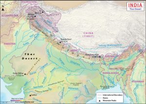
    About Thar Desert

    • The Thar Desert is the 18th largest subtropical desert globally and is one of the most densely populated deserts.
    • Approximately 40% of the human population in Rajasthan resides in the Thar Desert.
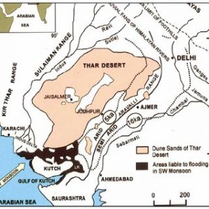
    • It extends from the Sutlej River and is bounded by the Rann of Kutch, the Aravalli Mountains, and the Indus River.
    • About 85% of the Thar Desert is located in India, with the remainder in Pakistan. 
    • In India, it spans across Rajasthan, Gujarat, Haryana, and Punjab as well.
    • Civilizations are believed to have thrived in the Thar region around 50,000 years ago across the extinct Saraswati River.
    • The Desert National Park (home to the endangered Great Indian Bustard, desert fox, desert cat, blackbuck, and Indian gazelle) is situated in the Thar Desert in the northwest Indian state of Rajasthan.

    Why the thar desert getting greener?

    • Climate Change Effects:
        • Alteration of Weather Patterns: Climate change is causing shifts in rainfall distribution in the thar desert area.
        • Potential for Vegetation Growth: The increased precipitation could provide favorable conditions for vegetation growth, contributing to the greening of the desert.
    • Indian Monsoon Dynamics:
        • Westward Extension of Indian Monsoon: The Indian monsoon, known for bringing heavy rainfall to eastern India, is now extending further westward into regions like the Thar Desert.
        • Impact on Moisture and Rainfall: This change in monsoon dynamics could lead to increased moisture and rainfall in the desert region, facilitating the growth of vegetation.
    • Expansion of Indian Ocean Warm Pool (IOWP):
        • Influence on Monsoon Patterns: The Indian Ocean Warm Pool (IOWP) influences monsoon patterns and rainfall distribution over the Indian subcontinent.
        • Westward Expansion due to Climate Change: Climate change is causing the IOWP to expand westward, potentially resulting in increased rainfall over semi-arid regions like the Thar Desert and promoting greening.
    • Water Management Practices:
        • Contribution to Greening: Effective water management practices, such as rainwater harvesting and irrigation techniques like johad, kuis, and kunds, may be playing a role in the greening of the Thar Desert.
        • Utilization of Water Resources: By harnessing and efficiently utilizing available water resources, local communities and authorities can support vegetation growth and ecosystem restoration efforts in the desert.
    • Introduction of Irrigation  
      • Commercial Cropping: Irrigation was introduced during British colonial rule in the 19th and 20th centuries to convert arid and semi-arid ecosystems into cropland.
      • Restrictions on Grazing: The right to graze animals was restricted to landowners who cultivated crops, leading to the transformation of nomadic pastoralists into sedentary agropastoralists.
    Sustainability of this transformation

    • Recent greening activities, largely on arid scrub savannahs, have threatened species adapted to such climates and have been linked to locust outbreaks.
    • The Indira Gandhi Canal project in the 1980s led to extensive crop cover in the Thar Desert, resulting in areas becoming infertile due to waterlogging and salinity.
    • Planting invasive species, such as prosopis juliflora and acacia tortilis, has led to habitat degradation and biodiversity loss.


    PYQ:

    [2018] Which of the following leaf modifications occur(s) in the desert areas to inhibit water loss?

    1. Hard and waxy leaves
    2. Tiny leaves
    3. Thorns instead of leaves

    Select the correct answer using the code given below:

    (a) 2 and 3 only

    (b) 2 only

    (c) 3 only

    (d) 1, 2 and 3

    [2020] The process of desertification does not have climate boundaries. Justify with examples.

    [2013] Major hot deserts in northern hemisphere are located between 20-30 degree north and on the western side of the continents. Why?  


  • Critical Minerals under iCET

    Why in the News?

    What are Critical Minerals?

    • Critical minerals are elements that are crucial to modern-day technologies and are at risk of supply chain disruptions.
    • These minerals are mostly used in making electronic equipment such as mobile phones, computers, batteries, electric vehicles, and green technologies like solar panels and wind turbines.
    • Many of these are required to meet the manufacturing needs of green technologies, high-tech equipment, aviation, and national defence.

    List of critical minerals includes:

    The centre has released a list of 30 critical minerals for India in 2023:

    1. Identified Minerals: Antimony, Beryllium, Bismuth, Cobalt, Copper, Gallium, Germanium, Graphite, Hafnium, Indium, Lithium, Molybdenum, Niobium, Nickel, Platinum Group elements (PGE), Phosphorous, Potash, Rare Earth Elements (REE), Rhenium, Silicon, Strontium, Tantalum, Tellurium, Tin, Titanium, Tungsten, Vanadium, Zirconium, Selenium and Cadmium.
    2. Fertilizer Minerals: Two minerals critical for fertilizer production, phosphorous and potash, are also included in the above list.

    Critical Mineral Blocks in India

    • Distribution: There are 20 blocks spread across eight states, including Tamil Nadu, Odisha, Bihar, Uttar Pradesh, Gujarat, Jharkhand, Chhattisgarh, and Jammu & Kashmir.
    • Types of Licenses: Four blocks are for a Mining License (ML), allowing immediate mining post-clearance. The remaining 16 blocks are for a Composite License (CL), permitting further exploration before potentially converting to an ML.
    • Approvals Required: Licensees must obtain various approvals, including forest clearance and environmental clearance.
    • Forest Land: Approximately 17% of the total concession area, or 1,234 hectares, is forest land.

    India’s Critical Mineral Imports

    • Lithium Imports: In FY23, India imported 2,145 tonnes of lithium carbonate and lithium oxide, costing Rs 732 crore.
    • Nickel and Copper Imports: The country imported 32,000 tonnes of unwrought nickel and 1.2 million tonnes of copper ore, costing Rs 6,549 crore and Rs 27,374 crore, respectively.
    • Import Dependence: India relies entirely on imports for lithium and nickel, and 93% for copper.

    Country-wise dependence:

    1. China: India heavily relies on China for the import of critical minerals like lithium, cobalt, nickel, and graphite.
    2. Australia: India is actively engaged with Australia for acquiring mineral assets, particularly lithium and cobalt, to secure its supply chain for critical minerals.
    3. Argentina, Bolivia, and Chile: India is engaging with these countries, known for their reserves of battery metals like lithium and cobalt, to diversify its sources for critical minerals.

    India’s Strategic Mineral Initiatives

    • Amendments to the Mines and Minerals (Development and Regulation) Act, 1957 support expanded exploration.
    • Establishment of Khanij Bidesh India Ltd. (KABIL) with equity from National Aluminium Company Ltd, Hindustan Copper Ltd, and Mineral Exploration and Consultancy Ltd for global mineral asset acquisition.

    International Collaborations and Partnerships

    • India joined the U.S.-led mineral security partnership to secure critical mineral supply chains.
    • Creation of an India-U.S. advanced materials research forum to foster collaboration in universities, laboratories, and private sectors.
    • Bilateral technology collaboration on neodymium-iron-boron and studies on minerals like lithium, titanium, gallium, and vanadium.

    Back2Basics: Indo-US Comprehensive Economic and Trade Agreement (iCET)

    Details
    Initiation Announced in May 2022, officially launched in January 2023
    Management Overseen by the National Security Councils of India and the US
    Objectives Enhance bilateral cooperation in critical and emerging technologies
    Focus Areas of the Initiative
    1. AI Research Agency Partnership
    2. Defense Industrial and Technological Cooperation
    3. Innovation Ecosystems
    4. Semiconductor Ecosystem Development
    5. Cooperation on Human Spaceflight
    6. Advancement in 5G and 6G Technologies
    Key Achievements
    • Quantum Coordination Mechanism
    • Public-private dialogues on telecommunications and AI
    • MoU on semiconductor supply chain
    • Defense industrial cooperation roadmap
    Upcoming Initiatives
    • Finalization of major jet engine deal
    • Launch of India-US Defence Acceleration Ecosystem (INDUS-X)
    • Strategic Trade Dialogue establishment


    PYQ:

    [2019] With reference to the management of minor minerals in India, consider the following statements:

    1. Sand is a ‘minor mineral’ according to the prevailing law in the country.
    2. State governments have the power to grant mining leases of minor minerals, but the powers regarding the formation of rules related to the grant of minor minerals lie with the Central Government.
    3. State Governments have the power to frame rules to prevent illegal mining of minor minerals.

    Which of the statements given above is/are correct?

    (a) 1 and 3

    (b) 2 and 3

    (c) 3 only

    (d) 1, 2 and 3

  • ‘Cold Lava’ Rivers flow in Philippines after Mount Canlaon eruption

    Why in the News?

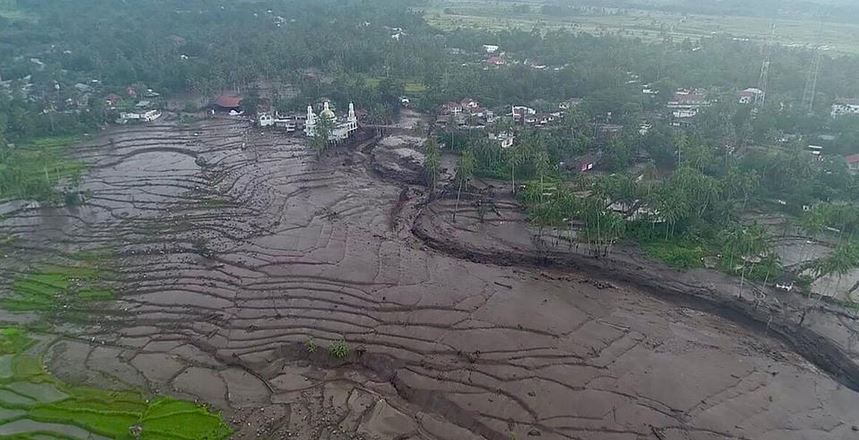
    • After Mount Canlaon erupted in the Philippines, cold lava started flowing through streets and rivers.
      • It was followed by ashfall, and dangers like floods and mudflows downstream.

    What is Cold Lava?

    • Cold lava, also known as “lahar,” is a mixture of water and rock fragments that flows rapidly down the slopes of a volcano, often triggered by heavy rainfall or volcanic eruptions.
    • The mixture forms a concrete-like substance that destroys everything in its path.
    • This can also include smooth, glassy textures or rough and jagged textures.

    Another example of cold Lava in the world

    • Mount Merapi, Indonesia (2023): An eruption of Mount Merapi resulted in the deaths of at least 23 climbers and spewed ash up to 3,000 meters into the air, covering towns and villages

    How harmful is Cold Lava?

    • Rain can carry cold lava down the slopes of a volcano during an eruption and into the path of nearby towns or villages.
    • According to the United States Geological Survey, cold lava has the power to crush and bury things in its path.
    • It also moves quickly like wet concrete and is considered more destructive than hot lava.

    About Mount Canlaon

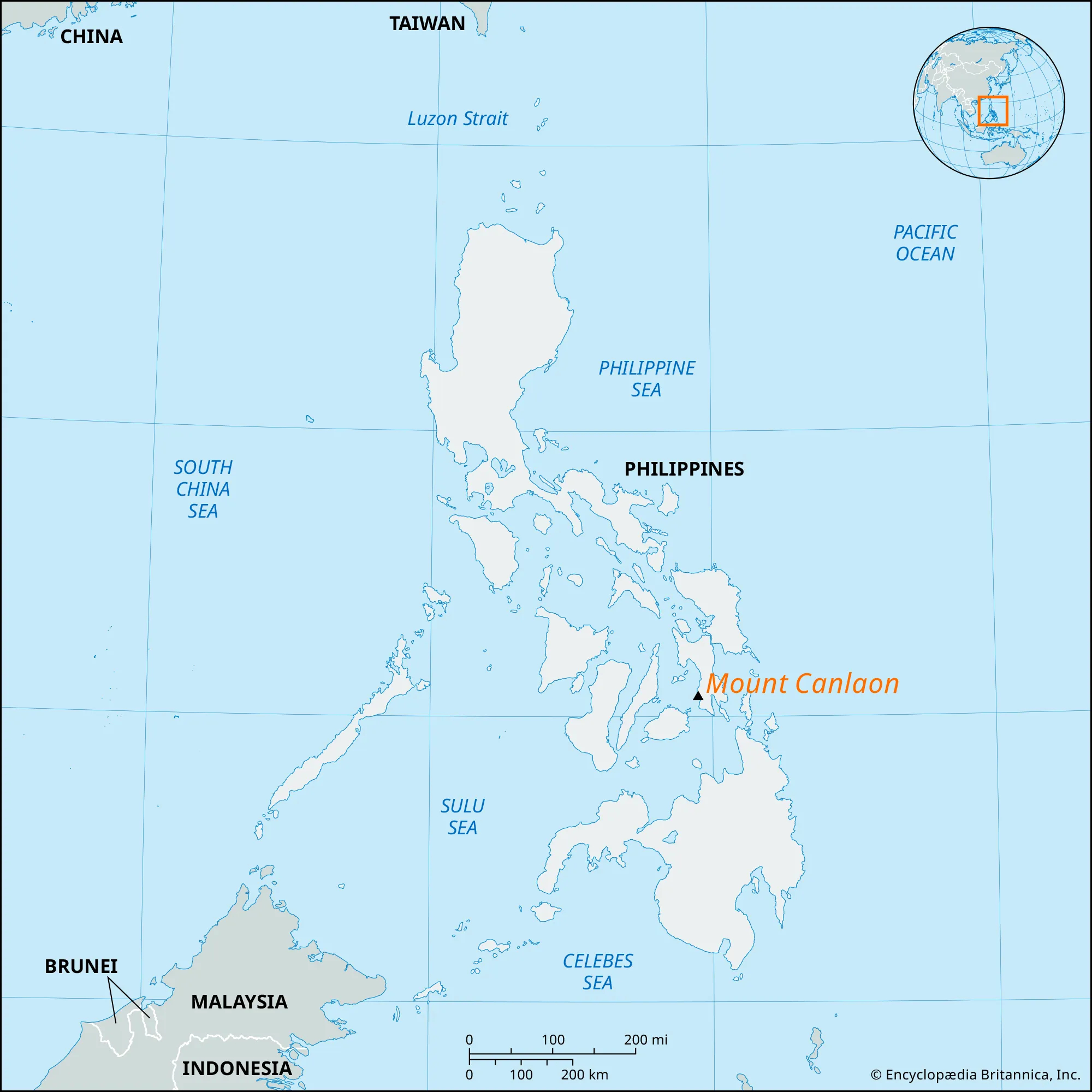
    • Mount Canlaon, located in the Philippines, is an active stratovolcano known for its frequent eruptions and volcanic activity.
    • It is situated on the island of Negros in the Visayas region of the Philippines.
    • It is part of the Pacific Ring of Fire, known for its high volcanic activity.
    • It poses hazards such as ash fall, lava flows, pyroclastic flows, and lahars (mudflows) that can endanger nearby communities and agriculture.


    PYQ:

    [2021] Discuss about the vulnerability of India to earthquake-related hazards. Give examples including the salient features of major disasters caused by earthquakes in different parts of India during the last three decades.

  • In news: Volkhov River

    Why in the News?

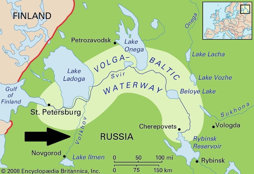
    Four medical students from India studying in a university in Russia drowned in Volkhov River near St. Petersburg.

    About Volkhov River

    • The Volkhov River is a significant waterway in northwestern Russia.
    • It is located in the Leningrad Oblast and Novgorod Oblast of Russia, in the northwestern part of the country.
    • It stretches approximately 224 kilometers (139 miles) from Lake Ilmen to Lake Ladoga.
    • Origin: It flows out of Lake Ilmen north into Lake Ladoga, the largest lake in Europe.
    • Tributaries: The Msta River is the largest tributary of the Volkhov.
    • Major Cities: Several cities and settlements are situated along the banks of the Volkhov River, including Novgorod, Veliky Novgorod, and Volkhov.

    PYQ:

    [2020] Consider the following pairs:

    River – Flows into

    1. Mekong – Andaman sea
    2. Thames – Irish Sea
    3. Volga – Caspian Sea
    4. Zambezi – Indian Ocean

    Which of the pairs above is/are correctly matched?

    (a) Only 1

    (b) Only 2

    (c) 3 Only

    (d) None of the above/More than one of the above.