💥Join UPSC 2027,2028 Mentorship (July Batch) + XFactor Notes & Microthemes PDF

Subject: Geographical Features

  • Hunga Tonga Volcanic Eruption

    Why in the News?

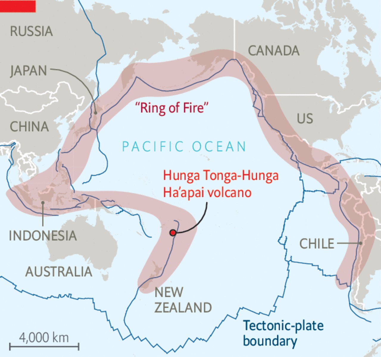
    Hunga Tonga-Hunga Ha’apai (Hunga Tonga) erupted in Tonga, triggering a tsunami and global seismic waves.

    About Hunga Tonga Volcano

    • The Hunga Tonga-Hunga Ha’apai volcano is situated in the western South Pacific Ocean, west of the main inhabited islands in the Kingdom of Tonga. It lies on the Pacific Ring of Fire.
    • It forms part of the Tofua Arc, within the larger Tonga-Kermadec volcanic arc, resulting from the subduction of the Pacific Plate beneath the Indo-Australian Plate.
    • It comprises two small uninhabited islands, Hunga-Ha’apai and Hunga-Tonga.
    • Hunga Tonga is one of 12 confirmed submarine volcanoes along the Tofua Arc.

    Key Findings on Hunga Tonga Eruption

    • The Hunga Tonga eruption primarily emitted water vapour, which reached the stratosphere, affecting ozone depletion and acting as a potent greenhouse gas. Minimal smoke was produced.

    Impact on Weather

    • Ozone Hole: The study reveals that Hunga Tonga contributed to the exceptionally large ozone hole in the preceding year and the unexpectedly wet summer of 2024.
    • Global Mean Temperatures: While the eruption had a negligible effect on global temperatures, it induced lasting regional disruptions in atmospheric wave patterns.
      • Traditionally, massive volcanic eruptions reduce temperatures by emitting sulfur dioxide, which forms sulphate aerosols reflecting sunlight.
    • Regional Effects: Anticipated changes include colder and wet winters in northern Australia, warmer winters in North America, and colder winters in Scandinavia until approximately 2029.

    Do you know?

    Previous volcanic eruptions, such as Tambora in 1815 and Samalas in 1257, have significantly impacted global climate, leading to phenomena like the “year without a summer” and the onset of the Little Ice Age.


    PYQ:

    [2021] Discuss about the vulnerability of India to earthquake-related hazards. Give examples including the salient features of major disasters caused by earthquakes in different parts of India during the last three decades.

  • Sundhnuksgigar Volcano erupts in Iceland

    Why in the News?

    Southwest Iceland witnessed the eruption of the Sundhnuksgigar volcano, triggering evacuations in the nearby areas.

    About Sundhnuksgigar Volcano 

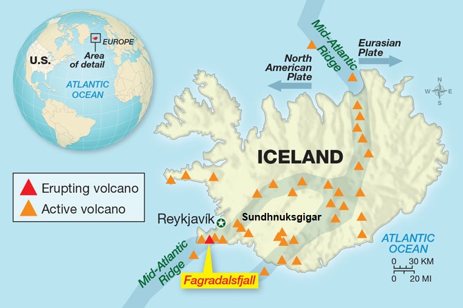
    • Sundhnuksgigar is a row of craters just outside the town of Grindavik on the Reykjanes peninsula
    • It is situated on the Mid-Atlantic Ridge, a divergent boundary where the Eurasian and North American tectonic plates are moving apart.

    What is a Volcano?

    • A volcano is a fissure or vent in the Earth’s crust through which gases, molten rock materials (lava), ash, steam, sulphur dioxide etc., are expelled during an eruption.
    • These openings occur where the rock layers in the Earth’s crust are relatively weak.
    • Volcanic activity is categorized as an endogenic process, originating from within the Earth.
    • Depending on the explosivity of the volcano, various extrusive and intrusive landforms can be formed.

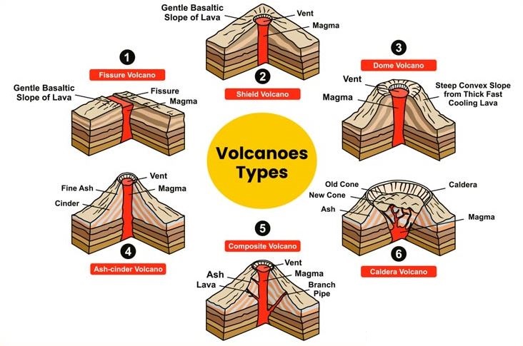
    Different types of volcanoes can be classified based on the frequency of eruption and the nature of the eruption:

    1.   Frequency of eruption:

    • Active volcanoes: Frequent eruptions in Pacific Ring of Fire: New Zealand, Southeast Asia, Japan, western Americas. Linked to plate tectonics, like Kilauea and Santa Maria. High seismicity, volcanic activity.
    • Dormant Volcanoes: These are not currently erupting but have the potential to erupt again in the future. An example is Mount Kilimanjaro in Tanzania, the highest mountain in Africa.
    • Extinct or inactive volcanoes: These have not erupted in the distant geological past. Dhinodhar Hill in Gujarat is an example.

    2.   Nature of Eruption:

    • Shield Volcanoes: Largest and least explosive volcanoes, formed from basalt lava. Often low in explosivity, except when water interacts. Hawaiian volcanoes exemplify this..
    • Composite Volcanoes: Volcanoes with cooler, thicker lava, built up through explosive eruptions. Layer ash, pyroclastic material, and lava flow. Examples: Mayon, Fuji, Rainier.
    • Calderas: The most explosive volcanoes, prone to collapsing inward during eruptions rather than building upwards. The resulting depressions are called calderas.
    • Flood Basalt Provinces: These volcanoes erupt highly fluid lava that travels long distances, covering vast areas with thick basalt flows.

    Reasons for Iceland’s Volcanism

    • Tectonic Activity: Iceland is situated on the Mid-Atlantic Ridge, where the Eurasian and North American plates diverge. This creates volcanic rift zones where magma rises to the surface, leading to eruptions.
    • Hotspots: Additionally, Iceland is positioned over a hotspot, contributing to heightened volcanic activity. Hotspots are areas where magma from the mantle rises towards the surface, fueling eruptions.
    • Subglacial Volcanism: Iceland’s volcanic activity is not limited to the surface; some eruptions occur beneath glaciers, leading to explosive interactions between lava and ice. These subglacial eruptions can produce powerful steam explosions, ash clouds, and catastrophic floods known as jokulhlaup.

    PYQ:

    [2021] Mention the global occurrence of volcanic eruptions in 2021 and their impact on the regional environment.

    [2013] Consider the following:

    1. Electromagnetic radiation
    2. Geothermal energy
    3. Gravitational force
    4. Plate movements
    5. Rotation of the earth
    6. Revolution of the earth

    Which of the above are responsible for bringing dynamic changes on the surface of the earth?

    (a) 1, 2, 3 and 4 only

    (b) 1, 3, 5 and 6 only

    (c) 2, 4, 5 and 6 only

    (d) 1, 2, 3, 4, 5 and 6

  • In news: Sharavathi River

    Why in the News?

    The National Green Tribunal (NGT) has directed the State Environment Impact Assessment Authority (SEIAA) and the mines and geology department to stop any unlawful/illegal sand mining in the Sharavathi River coastal zone.

    About National Green Tribunal (NGT)

    Description
    Establishment Formed in 2010 under the National Green Tribunal Act as a statutory body.
    Objective
    • To deal with cases related to environmental issues and ensure speedy implementation of decisions.
    • Responsible for giving many prominent decisions aimed at environmental protection, including addressing air pollution in Delhi and canceling coal block clearances.
    Composition
    • Headquartered in Delhi, chaired by a retired Supreme Court judge
    • Included Judicial Members and Expert Panel.
    Powers Empowered to decide on questions related to various environmental laws and hear civil cases concerning environmental issues:

    1. The Water (Prevention and Control of Pollution) Act, 1974;
    2. The Water (Prevention and Control of Pollution) Cess Act, 1977;
    3. The Forest (Conservation) Act, 1980;
    4. The Air (Prevention and Control of Pollution) Act, 1981;
    5. The Environment (Protection) Act, 1986;
    6. The Public Liability Insurance Act, 1991;
    7. The Biological Diversity Act, 2002.
    Exceptions Prohibited to hear any issues which are covered under:

    1. The Indian Forest Act, 1927,
    2. The Wildlife (Protection) Act, 1972, and
    3. Any other laws made by States which are related to protection of trees, forests, etc.
    Places
    • Principal bench in Delhi;
    • Additional benches in Bhopal, Pune, Kolkata, and Chennai.
    Governing Principles
    • Governed by principles of natural justice, not bound by Indian Evidence Act.
    • Applies principles of sustainable development, precautionary, and polluter pays.
    Review and Challenge
    • NGT orders can be reviewed as per Rule 22 of NGT Rules.
    • Can be challenged before the Supreme Court within 90 days.
    Jurisdiction
    • Jurisdiction over all civil cases involving a substantial question relating to environment.
    • Powers vested are the same as in a civil court under the Code of Civil Procedure, 1908.
    • Decisions are binding.
    Disposal of Cases Disposal of applications or appeals finally within 6 months of filing of the same.

    About Sharavathi River

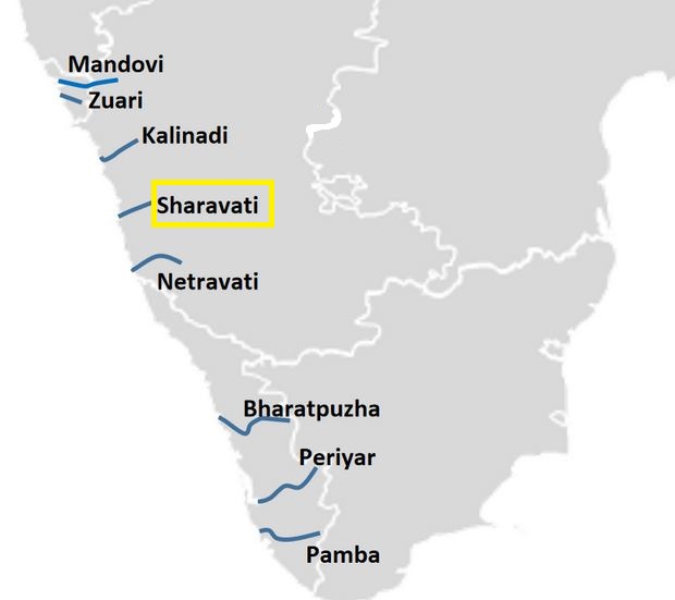
    • It originates and flows entirely within Karnataka.
    • It is among the few westward-flowing rivers in the country and a significant part of its basin lies in the Western Ghats.
    • Origin: The river originates at Ambutheertha in the Thirthahalli taluk.
    • Legend: According to ancient legend, the god Rama shot an arrow (Ambu) into the ground to quench his wife Sita’s thirst. The water that poured out was named “Thirtha,” hence the river’s name “Sharavati,” with “Shara” meaning arrow.

    Geography and Length:

    • The river stretches about 128 km (80 mi) and joins the Arabian Sea at Honnavar in Uttara Kannada district.
    • Jog Falls, formed by the Sharavati River, is located approximately 25 km from Siddapura.

    Tributaries and Basin:

    • Major tributaries: Nandihole, Haridravathi, Mavinahole, Hilkunji, Yennehole, Hurlihole, and Nagodihole.
    • River basin: divided between Uttara Kannada and Shimoga districts.
    • Pre-Cambrian rocks, including the Dharwar system and peninsular gneiss, dominate the basin.

    Soils and Agriculture:

    • Soils in the basin are predominantly lateritic and tend to be acidic, ranging from clay loamy to loamy.
    • Four soil orders are found: ultisols, alfisols, inceptisols, and entisols.

    Dams:

    • The Linganamakki Dam, constructed in 1964, spans the Sharavati River, with a catchment area of nearly 1,991.71 km2.
    • The Gerusoppa Dam, completed in 2002, primarily serves for electricity generation.

    Flora and Fauna:

    • The Sharavati Valley Wildlife Sanctuary declared in 1972, protects diverse ecosystems and endangered species.
    • The river basin is rich in biodiversity, home to rare species of flora and fauna.

    Regulation of Sand Mining in India:

    Mines and Minerals Act, 1957

    Definition of Sand as a Minor Mineral Sand is categorized as a minor mineral under section 3(e) of the MMDR Act.
    State Governments’ Role Section 15 empowers state governments to regulate mineral concessions for minor minerals, leading to the formulation of state-specific concession rules.
    Control of Illegal Mining Section 23C places the jurisdiction over controlling illegal mining under the purview of state governments.

    Sustainable Sand Mining Management Guidelines, 2016

    Purpose Released by the Ministry of Environment, Forest and Climate Change, aims to promote scientific and environmentally friendly sand mining practices.
    Recommendations Emphasizes sustainable sand extraction, monitoring, and district-wise mapping of sand availability.

    Sand Mining Framework, 2018

    Issued by Released by the Ministry of Mines, provides states with guidance for policy formulation and combating illegal sand mining.
    Recommended Measures Suggests geo-fencing, GPS-enabled transportation tracking, price control, involvement of women’s self-help groups, and exploration of alternative sand sources.


    PYQ:

    [2018] Which of the following is/are the possible consequence/s of heavy sand mining in riverbeds?

    1. Decreased salinity in the river
    2. Pollution of groundwater
    3. Lowering of the water-table

    Select the correct answer using the code given below:

    (a) 1 only

    (b) 2 and 3 only

    (c) 1 and 3 only

    (d) 1, 2 and 3

    [2019] With reference to the management of minor minerals in India, consider the following statements :

    1. Sand is a ‘minor mineral’ according to the prevailing law in the country.
    2. State governments have the power to grant mining leases of minor minerals, but the powers regarding the formation of rules related to the grant of minor minerals lie with the Central Government.
    3. State Governments have the power to frame rules to prevent illegal mining of minor minerals.

    Which of the statements given above is/are correct?

    (a) 1 and 3 only

    (b) 2 and 3 only

    (c) 3 only

    (d) 1, 2 and 3

  • In news: Campi Flegrei Super Volcano 

    Why in the News?

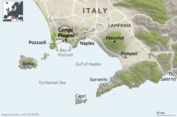
    A 4.4 magnitude earthquake struck Italy’s Campi Flegrei super volcano, with Pozzuoli as the epicentre. Felt as far as Naples, it’s the strongest tremor in 40 years

    Bradyseism Concerns near Campi Flegrei:

    • Campi Flegrei is prone to bradyseism, where ground elevation changes due to subsurface pressure.
    • The area, located 50 kilometres from Mt. Vesuvius, is undergoing a new cycle of bradyseism, according to volcanologists.
    • Over 500,000 people reside in the red zone adjacent to Campi Flegrei, prompting the Italian Civil Protection Agency to update evacuation plans.

    About Campi Flegrei Volcano

    • Campi Flegrei, also known as the Phlegraean Fields, is a large volcanic area located in the western suburbs of Naples, Italy.
    • It is one of the most active volcanic systems in the world and has been active for at least 50,000 years.

    Its Volcanic System:

    • Location: Campi Flegrei is situated within the Campanian volcanic arc in southern Italy, extending from the city of Naples to the Gulf of Pozzuoli.
    • Geological Formation: The volcanic system of Campi Flegrei is characterized by a large caldera, which is a collapsed volcanic crater, surrounded by numerous volcanic vents, craters, and lava domes. The caldera has a diameter of about 13 kilometers (8 miles).
    • Volcanic Activity: Campi Flegrei is considered a supervolcano due to its size and potential for large eruptions. It has experienced numerous periods of volcanic activity throughout its history, including explosive eruptions, lava flows, and phreatic (steam-driven) eruptions.
    • Terrain Features: The landscape of Campi Flegrei is characterized by volcanic features such as craters, fumaroles (steam vents), mud pots, and hot springs.

    PYQ:

    [2021] Mention the global occurrence of volcanic eruptions in ‘2021’ and their impact on regional environment.

    [2018] Consider the following statements:

    1. The Barren Island volcano is an active volcano located in the Indian Territory.
    2. Barren Island lies about 140 km east of Great Nicobar.
    3. The last time the Barren Island volcano erupted was in 1991 and it has remained inactive since then.

    Which of the statements given above is/are correct?

    (a) 1 only

    (b) 2 and 3

    (c) 3 only

    (d) 1 and 3

  • Speculoos-3b: A New Earth-Sized Exoplanet Discovered

    Why in the News?

    • Astronomers have identified a new Earth-sized exoplanet, named Speculoos-3b, orbiting an ultracool red dwarf star.

    Back2Basics: Red Dwarf Star

    • A red dwarf is the most common type of star in the Milky Way galaxy.
    • However, due to their low luminosity, individual red dwarfs cannot be easily observed.
    • Proxima Centauri, the star nearest to the Sun, is a red dwarf, as are fifty of the sixty nearest stars.
    • According to some estimates, red dwarfs make up three-quarters of the fusing stars in the Milky Way.

    About Speculoos-3b

    • Speculoos-3b is an Earth-sized exoplanet recently discovered orbiting an ultracool dwarf star.
    • It was discovered by a team of astronomers led by Michael Gillon from the University of Liege in Belgium.
    • It is located approximately 55 light-years away from Earth.
    • Due to its short orbital period, Speculoos-3b receives almost ten times more energy per second than Earth does from the Sun.

    SPECULOOS Project 

    • Project Overview: The discovery was made under the SPECULOOS project, aimed at exploring exoplanets around ultra-cool dwarf stars.
    • The SPECULOOS Southern Observatory is a project carried out by the University of Liège (Belgium) and the Cavendish Laboratory in Cambridge (United Kingdom)

    Astrophysical Significance of the Discovery

    • Prevalence of Ultracool Dwarfs: Ultracool dwarf stars, like the host of Speculoos-3b, constitute about 70% of all stars in our galaxy and are known for their longevity, surviving up to 100 billion years.
    • Importance for Life’s Potential: The extended lifespan of these stars provides a stable environment that could potentially support the development of life on orbiting planets.

    PYQ:

    [2015] The term ‘Goldilocks Zone’ is often seen in the news in the context of:

    (a) the limits of habitable zone above the surface of the Earth

    (b) regions inside the Earth where shale gas is available

    (c) search for the Earth-like planets in outer space

    (d) search for meteorites containing precious metals

  • In News: Mahi River 

    Why in the News?

    Incidences of people drowning down into the Mahi River have become more frequent.

    About Mahi River

    • The Mahi River originates in the Vindhya Range of Madhya Pradesh (hot semi-arid and watershed region), near Dhar.
    • It flows northward through Madhya Pradesh before turning westward upon entering Rajasthan. It then moves southwest, passing through Gujarat, and eventually empties into the Arabian Sea.
    • The river stretches for about 580 kilometers.
      • Soil Type: The Mahi River Basin consists of Deep Black soil (southern region) and Alluvial soil (northern region).
      • Major Tributaries: the Som, the Anas, the Panam, and the Goma.
      • Major Dams: Kadana Dam and the Mahi Bajaj Sagar (Banswara) Dam are significant hydroelectric and irrigation projects on the Mahi River.
      • Biodiversity: Supports diverse flora and fauna, including endangered species like the Indian Skimmer and Gharial.

    Key Features:

    • It is surrounded by the Aravalli Hills to the north and northwest, the Malwa Plateau to the east, the Vindhyas to the south, and the Gulf of Khambhat to the west.
    • One of the most notable features of the Mahi River is its crossing of the Tropic of Cancer twice; once in Madhya Pradesh and again near the Gujarat-Rajasthan border.

    PYQ:

    [2017] With reference to river Teesta, consider the following statements:

    1. The source of river Teesta is the same as that of Brahmaputra but it flows through Sikkim.

    2. River Rangeet originates in Sikkim and it is a tributary of river Teesta.

    3. River Teesta falls into Bay of Bengal at the border of India and Bangladesh.

    Which of the statements given above is/are correct?

    (a) 1 and 3 only

    (b) 2 only

    (c) 2 and 3 only

    (d) 1, 2 and 3

    With inputs from: https://indiawris.gov.in/downloads/Mahi%20Basin.pdf

  • Aurora Borealis: What are Northern and Southern lights? Why do they occur?

    Why in the news?

    • In a rare event, the night sky over Hanle village in Ladakh was illuminated by the northern lights or aurora borealis.
      • Concurrently, the southern lights, or aurora australis, were observed in New Zealand and Australia.

    What are Auroras?

    • Auroras are natural light displays that appear as bright, swirling curtains in the night sky.
    • They are typically seen near the Poles but can occasionally be observed at lower latitudes.
    • These lights can display a range of colors, including blue, red, yellow, green, and orange, due to the interaction of solar particles with different gases in the Earth’s atmosphere.
    • The phenomenon is known as:
    1. Aurora borealis in Northern Hemisphere and
    2. Aurora australis in Southern Hemisphere

    What causes Auroras?

    • Interaction with Earth’s Magnetic Field: As the solar wind approaches Earth, it interacts with the planet’s magnetic field, causing some charged particles to enter the atmosphere near the poles.
    • Interaction with Gases: These particles interact with gases in the upper atmosphere, producing colourful flashes of light. Collision with oxygen produces green light, while interaction with nitrogen results in shades of blue and purple.

    Reasons for Aurora in Ladakh:

    • Intense Solar Activity: Auroras can extend to lower latitudes during periods of intense solar activity, such as solar flares and coronal mass ejections (CMEs).
      • The CMEs are from the AR13664 region of the sun that has produced several high-energy solar flares
    • Localized magnetic anomalies: Variations in Earth’s magnetic field could potentially influence the occurrence of auroras in specific areas, including regions at lower latitudes.

    Impact on Tech Infrastructure 

    • Auroras can pose challenges to space-dependent technologies and operations.
    • Disruptions in Global Positioning Systems (GPS), radio communications, flight operations, power grids, and space exploration endeavors may occur during such events.

    PYQ:

    [2022] If a major solar storm (solar flare) reaches the Earth, which of the following are the possible effects on the Earth?

    1. GPS and navigation systems could fail.
    2. Tsunamis could occur at equatorial regions.
    3. Power grids could be damaged.
    4. Intense auroras could occur over much of the Earth.
    5. Forest fires could take place over much of the planet.
    6. Orbits of the satellites could be disturbed.
    7. Shortwave radio communication of the aircraft flying over Polar Regions could be interrupted.

    Select the correct answer using the code given below:

    (a) 1, 2, 4 and 5 only
    (b) 2, 3, 5, 6 and 7 only
    (c) 1, 3, 4, 6 and 7 only
    (d) 1, 2, 3, 4, 5, 6 and 7


  • Positive Indian Ocean Dipole (IOD) to aid Monsoon this year

    Why in the News?

    Australian weather agencies predict the possible return of a positive Indian Ocean Dipole (IOD) in the latter half of 2024.

    What is the Indian Ocean Dipole (IOD)?

    • The IOD is also known as the Indian Nino. It is characterized by the differential heating of ocean waters in the eastern and western parts of the basin.
    • Similar to the El Nino Southern Oscillation (ENSO) in the Pacific, the IOD involves phases of ocean temperatures and atmospheric conditions that affect weather patterns across the region and beyond.
    • There are two main phases of the IOD:
      • Positive Phase: In this phase, the western Indian Ocean becomes warmer than average, and the eastern part cooler than average. This results in greater convection and rainfall over the western Indian Ocean and adjacent land areas like East Africa, while reducing rainfall over the eastern Indian Ocean and places like Indonesia and Australia.
      • Negative Phase: The opposite conditions prevail during this phase, with cooler waters in the western Indian Ocean and warmer waters in the east. This leads to increased rainfall in the eastern Indian Ocean regions and drier conditions in the western part and East Africa.

    Back2Basics: El Nino-Southern Oscillation (ENSO)

    • El Nino and La Nina are two opposite phases of the El Nino-Southern Oscillation (ENSO) cycle.
    • ENSO is a naturally occurring phenomenon that involves the interaction between the ocean and atmosphere in the equatorial Pacific.

    Here is a detailed comparison of El Nino and La Nina

    El Nino La Nina
    Definition Warmer-than-normal sea surface temperatures Cooler-than-normal sea surface temperatures
    Frequency Every two to seven years Every two to seven years
    Duration Several months to a year or more Several months to a year or more
    Impact on winds Weakens trade winds, leading to changes in patterns Strengthens trade winds, leading to changes in patterns
    Impact on rains Reduces rainfall and can cause droughts Increases rainfall and can cause flooding
    Impact on temp. Warmer-than-average temperatures Colder-than-average temperatures
    Global effects Droughts in Asia and Africa, floods in Americas Floods in Asia and Africa, droughts in South America


    Impact on the Indian Monsoon:

    The Indian Ocean Dipole has significant impacts on the Indian monsoon system:

    1. Positive IOD often coincides with a stronger Southwest Monsoon, bringing more rainfall to India. This is due to the shift in warm water and accompanying convection towards India, which enhances the monsoon rainfall.
    2. Negative IOD can weaken the Southwest Monsoon, resulting in less rainfall and potential drought conditions in India. The shift of warm water away from India reduces the necessary heat and moisture that drive the monsoon rains.

    PYQ:

    [2017] With reference to ‘Indian Ocean Dipole (IOD)’ sometimes mentioned in the news while forecasting Indian monsoon, which of the following statements is/are correct?

    1. IOD phenomenon is characterised by a difference in sea surface temperature between tropical Western Indian Ocean and tropical Eastern Pacific Ocean.

    2. An IOD phenomenon can influence an El Nino’s impact on the monsoon.

    Select the correct answer using the code given below:

    (a) 1 only

    (b) 2 only

    (c) Both 1 and 2

    (d) Neither 1 nor 2

  • Eta Aquariid Meteor Shower and how it can be spotted

    Why in the news?

    • The Eta Aquariid meteor shower, an annual event, will reach its peak on May 5 and 6.
    • This meteor shower is a result of Earth intersecting with the debris trail left by Halley’s Comet during its orbit.

    Halley’s Comet

    • Halley’s Comet is a short-period comet visible from Earth every 75–79 years.
    • It was last seen in Earth’s skies in 1986 and was met in space by an international fleet of spacecraft. It will return in 2061 on its regular journey around the Sun.

    What are Meteoric Showers?

    • Meteors, fragments of dust, rock and ice, are expelled from comets during their celestial orbits around the sun.
    • The Earth’s atmosphere heats these space rocks as they descend, leaving luminous streaks of gas in their way.
    • NASA’s records confirms existence of over 30 meteor showers annually.

    Origin of Meteor Showers:

    • Meteor showers originate from comets, remnants of the solar system’s formation composed of dust, rock, and ice.
    • Comets orbit the Sun in highly elliptical paths, and as they approach, they heat up, releasing gases and dust to form a glowing head and a tail stretching millions of miles.
    • When Earth traverses through the debris left behind by comets along their orbital plane, we witness meteor showers.

    About Eta Aquariids

    • Known for their rapid speed, Eta Aquariid meteors produce long, glowing tails lasting several minutes.
    • Observers in the Southern Hemisphere can witness approximately 30 to 40 meteors per hour during the peak, while those in the Northern Hemisphere may see around 10 meteors per hour.
    • They seem to originate from the Aquarius constellation, hence the name ‘Eta Aquariid.’

    PYQ:

    [2014] What is a coma, in the content of astronomy?

    (a) Bright half of material on the comet

    (b) Long tail of dust

    (c) Two asteroids orbiting each other

    (d) Two planets orbiting each other

  • Mapping: Garo Hills

    Why in the news?

    • Geological Survey of India (GSI) explorers have made a breakthrough, uncovering ancient fossils in Tolegre, South Garo Hills of Meghalaya.
    • It is speculated that the fossils could be linked to the genera Rhodocetus or Amulocetus (now extinct), considered ancestors of modern whales.

    About Garo Hills

    • The Garo Hills, located in Meghalaya, are part of the Garo-Khasi range, one of the hill ranges in the northeastern region of India.
    • They are situated in the western part of Meghalaya, bordering Bangladesh to the south and west.
    • The terrain of the Garo Hills is rugged and hilly, characterized by dense forests, steep slopes, and deep valleys.
    • The Nokrek is highest Peak, which stands at approximately 1,415 meters (4,642 feet) above sea level.
    • The climate in the Garo Hills is typically humid subtropical, with heavy rainfall during the monsoon season, which usually lasts from June to September.
    • Numerous rivers and streams, including the Brahmaputra, Someshwari, and Jinjiram rivers crisscross this region.
    • The region is also known for its picturesque waterfalls, such as the Pelga Falls, located near Tura, the largest town in the Garo Hills.
    • The Nokrek National Park, located within, is recognized as a UNESCO Biosphere Reserve and is home to various endangered species, including the Asian elephant and the red panda.
    • The Garo Hills are inhabited predominantly by the Garo tribe, one of the major ethnic groups in Meghalaya.


    PYQ:

    [2013] Consider the following pairs:

    1. Nokrek Bio-Sphere Reserve : Garo Hills

    2. Logtak (Loktak) Lake : Barail Range

    3. Namdapha National Park: Daphla Hills

    Which of the above pairs is/are correctly matched?

    (a) 1 only

    (b) 2 and 3 only

    (c) 1, 2 and 3

    (d) None