đŸ’„Join UPSC 2027,2028 Mentorship (July Batch) + XFactor Notes & Microthemes PDF

Subject: Geography

  • Kavachi Volcano

    Why in the News?

    Scientists have reported rare underwater footage showing sharks living inside the crater of Kavachi volcano, near the Solomon Islands. This discovery challenges earlier assumptions about marine survival in extreme volcanic environments.

    About Kavachi Volcano

    • A shallow submarine volcano located in the South Pacific Ocean
    • Situated south of Vangunu Island in the Solomon Islands
    • Lies on the Pacific Ring of Fire, a highly tectonically active zone
    • Among the few active and visible undersea volcanoes in the world

    Volcanic Activity

    • Known for frequent but unpredictable eruptions
    • First documented eruptive activity in 1939
    • Has experienced multiple temporary island forming events

    Prelims Pointers

    ‱ Type: Submarine volcano
    ‱ Location: South Pacific Ocean
    ‱ Tectonic setting: Pacific Ring of Fire
    ‱ Key feature: Temporary island formation
    ‱ Recent relevance: Sharks observed inside a volcanic crater

    [2024] Consider the following: 1. Pyroclastic debris 2. Ash and dust 3. Nitrogen compounds 4. Sulphur compounds. How many of the above are products of volcanic eruptions? 

    (a) Only one

    (b) Only two

    (c) Only three

    (d) All four 

  • Hormuz Island

    Why in the News?

    ‱ A rare natural phenomenon turned the coastlines of Hormuz Island into a blood red landscape, drawing global attention

    About Hormuz Island

    ‱ Location: Iran, on the Strait of Hormuz
    ‱ Lies between the Persian Gulf and the Gulf of Oman
    ‱ Situated about 8 km off the Iranian coast
    ‱ Area: 41.9 sq km
    ‱ A hilly island with distinctive geomorphology

    Geological Features

    ‱ Composed mainly of sedimentary rocks and volcanic ash
    ‱ Dominant red colour due to high iron oxide content
    ‱ Presence of hematite mineral gives the soil its deep red hue
    ‱ Ocean waves turn pink when they wash over iron rich sands

    Soil and Climate

    ‱ Experiences low precipitation
    ‱ Soil and water are saline in nature
    ‱ Landscape is largely barren

    Unique Identity

    ‱ Known as Rainbow Island due to multi coloured soil
    ‱ Sand and soil colours include red, gold, silver, and white

    Human Settlement and Livelihood

    ‱ Hormuz village is the only permanent settlement
    ‱ Fishing is the primary source of livelihood
    ‱ Inhabited mainly by the Bandari ethnic group

    What is the importance of developing Chabahar Port by India? (2017)

    (a) India’s trade with African countries will enormously increase. 

    (b) India’s relations with oil-producing Arab countries will be strengthened. 

    (c) India will not depend on Pakistan for access to Afghanistan and Central Asia. 

    (d) Pakistan will facilitate and protect the installation of a gas pipeline between Iraq and India.

  • Bitra Island

    Why in the News?

    The Chief of Staff, Southern Naval Command, announced that the Indian Navy is setting up a detachment on Bitra Island, and the facility is almost completed. This will make Bitra the third island in Lakshadweep to host a defence establishment.

    About Bitra Island

    • Location: Northern Lakshadweep, Arabian Sea
    • Smallest inhabited island in Lakshadweep
    • Land area: 0.105 sq. km
    • Dimensions: Length – 0.57 km | Width – 0.28 km
    • Lagoon area: 45.61 sq. km (significantly larger than the landmass)
    • Population (2011): 271

    Key Features

    • Cultural Significance: Hosts a shrine of Malik Mulla, an Arab saint believed to be buried there.
      • Important pilgrimage site for locals across Lakshadweep.
    • Ecology: Once covered with thick shrubs.
      • Historically a major breeding ground for seabirds, which declined in the 19th century due to human interference.
    • Climate: Similar to Kerala’s climate.
    • Hottest months: March–May
    • Temperature: 25°C – 35°C
    • Humidity: 70–76% throughout most of the year.

    Strategic Importance

    • Located in a key position in the Arabian Sea, critical for maritime security.
    • Enhances surveillance over sea lanes close to India’s western maritime frontier.
    • Adds to Lakshadweep’s defence infrastructure:
      • INS Dweeprakshak – Kavaratti
      • INS Jatayu – Minicoy
      • New Navy detachment – Bitra Island

    Prelims Pointers

    • Bitra = smallest inhabited island of Lakshadweep
    • Features a shrine of Malik Mulla
    • Large lagoon-to-land ratio
    • Strategically vital for India’s naval presence in the Arabian Sea
    • Climate closely resembles Kerala
    Which one of the following pairs of islands is separated from each other by the ‘Ten Degree Channel’? (2014)

    (a) Andaman and Nicobar 

    (b) Nicobar and Sumatra 

    (c) Maldives and Lakshadweep 

    (d) Sumatra and Java

  • India’s disaster response, a slippery slope for federalism

    Introduction

    The Wayanad tragedy of July 2024, claiming nearly 300 lives and destroying thousands of homes, revealed deep weaknesses in India’s disaster financing structure. Though Kerala estimated losses at â‚č20,820 crore, the Union approved only â‚č260 crore, signalling a widening disconnect between State needs and Union allocations. As climate disasters intensify, India’s disaster-risk financing model shows visible drift, raising questions on fiscal federalism, institutional design, and equity.

    Why in the news

    The Wayanad landslides (July 2024) brought focus to an unprecedented gap between State-estimated losses (â‚č20,820 crore) and Union-approved relief (â‚č260 crore). For the first time, the mismatch was so steep that the State sought a special memorandum to claim recovery support. This experience, mirroring similar delays in Himachal, Uttarakhand, Assam, and Odisha, highlights growing centralisation of disaster financing, outdated relief norms, and procedural bottlenecks that slow down urgent aid.

    Where is the drift in India’s disaster financing framework?

    1. Two-tier structure: SDRF (shared) and NDRF (Union-funded) forms the legal basis under Disaster Management Act, 2005; however, practice diverges from cooperative design.
    2. Outdated norms: Relief amounts, like â‚č6 lakh for death and â‚č1.2 lakh for fully damaged houses, have not kept pace with current needs.
    3. Limited use flexibility: States face constraints using SDRF funds beyond notified categories, leaving gaps during reconstruction needs.
    4. Delayed releases: Sequential approvals (State-Centre-High-level committees) slow down disbursal even during severe calamities.

    Why does classification and discretion weaken the system?

    1. Ambiguous disaster definition: The Act gives no clarity on what qualifies as a ‘severe’ disaster for NDRF aid, leaving room for variable central discretion.
    2. Procedural-not automatic triggers: India relies on approvals; unlike global practices using rainfall thresholds, satellite data, or actuarial triggers.
    3. Bias in allocations: Finance Commission criteria use population and geography proxies; actual vulnerability (poverty, hazard exposure) gets underestimated.

    How did the Wayanad episode reveal institutional deficiencies?

    1. Unspent SDRF balances: Kerala had â‚č780 crore in SDRF and earlier deposits but faced constraints using them due to rigid rules.
    2. Cuts in interest support: â‚č529 crore Centre interest-free support was withdrawn, reducing flexibility.
    3. Mismatch in severity classification: Landslides treated as “severe disaster” only after delays, reducing timely access to NDRF.
    4. Comparative delays: Similar underfunding seen in Himachal, Uttarakhand, Assam, Nagaland, and Karnataka after recent floods.

    How can global models inform India’s reforms?

    1. US FEMA: Catastrophe declarations based on clear, measurable thresholds; faster releases.
    2. Mexico FONDEN: Automatic fund release beyond rainfall limits; rules-based framework.
    3. Philippines model: Quick-response funds tied to rainfall-fatality indices.
    4. Australia: Funds tied to State expenditure and accountability.
    5. African/Caribbean insurance pools: Satellite-data triggers reduce discretion and delays.

    What is needed to restore India’s federal spirit?

    1. Sixteenth Finance Commission: Expected to overhaul financing architecture, align relief norms to actual costs, revise allocation formulas, and integrate vulnerability indicators.
    2. Unified disaster authority: A national, airshed-like authority beyond NCR to manage transboundary disaster risks.
    3. Stable fiscal autonomy: Allow States greater control over disaster funds without excessive approvals.
    4. Rules-based financing: Objective, measurable triggers (rainfall intensity, satellite data, loss-to-GSDP ratio) to reduce delays.

    Conclusion

    India’s disaster-response financing, originally structured for cooperative federalism, has shifted toward centralised discretion, resulting in mismatches between actual losses and approved relief. The Wayanad landslides demonstrate the urgent need for rules-based, automatic, and scientifically triggered fund release mechanisms. Strengthening fiscal autonomy, updating norms, and adopting global best practices are essential for a resilient, federal, and future-ready disaster management system.

    PYQ Relevance

    [UPSC 2020] Discuss the recent measures initiated in disaster management by the Government of India departing from the earlier reactive approach.

    Linkage: The question aligns with the article’s focus on outdated, reactive SDRF-NDRF procedures and delays exposed during the Wayanad disaster. It reinforces the need for proactive, rules-based, science-triggered disaster financing and stronger federal coordination.


  • Volcanic Eruption in Ethiopia and Impact on India

    Why in the news?

    The Hayli Gubbi volcano in Ethiopia’s Afar region erupted on 23 November 2025 after nearly 12,000 years of dormancy, producing a massive ash plume rising to ~14 km (45,000 ft). High-level winds transported volcanic ash across the Red Sea and Arabian Peninsula towards western and northern India, causing temporary disruption in aviation operations.

    Key Facts: Location & Geological Background 

    Hayli Gubbi Volcano

    • Type: Shield volcano
    • Location: Afar Region, Ethiopia (part of the East African Rift System)
    • Dormancy: Last known activity ~10,000–12,000 years ago (Holocene threshold)
    • Geological Setting: Lies on the triple junction where the Arabian, Nubian, and Somali plates are diverging → high tectonic activity.

    East African Rift System (EARS)

    • A major continental rift zone.
    • Known for active volcanism (Erta Ale, Dabbahu, Nabro, etc.).
    • Possible future site of a new ocean basin due to plate divergence.

    Impact on India

    1. Flight Disruptions

    • Several international flights cancelled or delayed (Delhi, Mumbai, Hyderabad, Kochi).
    • Airlines: Air India, IndiGo, Akasa Air initiated precautionary measures.
    • Aircraft inspections ordered for those that flew through potentially affected air corridors.

    2. Airspace Management

    • Civil Aviation Ministry, Air Traffic Control (ATC), and the India Meteorological Department (IMD) issued continuous advisories.\
    • No major safety threat, but routing adjustments and cancellations made as precaution.

    3. No Impact on Local Weather or Air Quality

    • IMD clarified:
      • Ash remained in upper troposphere.
      • No impact on ground-level AQI.
      • Delhi’s poor air quality is unrelated, caused by local pollution.

    4. Clearance Timeline

    • Ash plume expected to move completely towards China by 7:30 pm, Nov 25.

    Why Aviation Avoids Volcanic Ash? 

    • Ash melts inside jet engines → forms glassy deposits → engine flameout.
    • Damages navigation systems & windshields.
    • Reduces visibility.
    • Can cause stalls, loss of thrust, and total engine failure.

    Relevant Organisation:
    ▶ Volcanic Ash Advisory Centers (VAACs) issue global alerts—here, Toulouse VAAC monitored the plume.

    Consider the following: (2024)

    1. Pyroclastic debris 

    2. Ash and dust 

    3. Nitrogen compounds 

    4. Sulphur compounds 

    How many of the above are products of volcanic eruptions? 

    (a) Only one 

    (b) Only two 

    (c) Only three 

    (d) Only four

  • Low-Pressure Area in Bay of Bengal (November 2025) 

    Why in the news?

    According to the India Meteorological Department (IMD), a low-pressure area formed over the Bay of Bengal on November 22, 2025. It is expected to intensify into a depression by November 24 and move west-northwestwards.

    What Has the IMD Reported?  

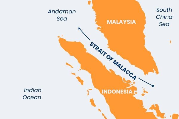
    a) Formation: Low-pressure area formed near the Malacca Strait over the South Andaman Sea. It arose due to a cyclonic circulation.

    b) Likely Path: Expected to move west-northwestwards. Likely to intensify into a depression over southeast Bay of Bengal & adjoining south Andaman Sea by November 24.

    c) Further IntensificationCould intensify further over the southwest Bay of Bengal within 48 hours after formation. IMD is uncertain whether it will develop into a cyclonic storm.

    d) State Impact (Odisha & Coastal Areas): System is far from Odisha coast → dry weather Farmers in coastal and southern regions have started harvesting mature paddy in anticipation of possible heavy rains. The State Agriculture Department has not yet issued advisories.

    (2015) In the South Atlantic and South-Eastern Pacific regions in tropical latitudes, cyclone does not originate. What is the reason? 

    (a) Sea surface temperatures are low 

    (b) Inter-Tropical Convergence Zone seldom occurs 

    (c) Coriolis force is too weak 

    (d) Absence of land in those regions

  • Sakurajima Volcano erupts in Japan’s Kyushu

    Why in the News?

    Japan’s Sakurajima volcano has erupted several times sending ash plumes up to 4.4 km into the atmosphere.

    Sakurajima Volcano erupts in Japan's Kyushu

    About Sakurajima Volcano:

    • Location: Kagoshima Prefecture, Kyushu, sitting on the southern rim of the Aira caldera inside Kagoshima Bay.
    • Geological Origin: Linked to formation of the Aira caldera (22,000–29,000 years ago); Sakurajima developed as a post-caldera cone about 13,000 years ago.
    • Volcano Type: A classic stratovolcano built from alternating lava and ash layers; active vents include Minamidake crater and the Showa flank crater.
    • Physical Features: Height 1,117 m, circumference ≈50 km; originally an island until 1914 lava flows connected it to the Osumi Peninsula.
    • Eruption Style: Dominantly Strombolian eruptions (ash, bombs, lapilli) but historically capable of large Plinian eruptions.
    • Historical Activity: Continuous eruptive record since 963 AD; major episodes in 1471–76, 1779–82, and the 1914 catastrophic eruption.
    • Risk Status: Considered one of Japan’s most dangerous volcanoes due to high activity, caldera-linked magma supply and extreme proximity to inhabited zones.

    What makes it unique?

    • Near-Continuous Activity: Erupts hundreds of times annually, ranking among the world’s most persistently active volcanoes.
    • Caldera System: Built on the Aira caldera, giving it a deep, complex, highly active magma plumbing network.
    • Landform Transformation: The 1914 eruption converted Sakurajima from an island into a peninsula, an unusual event in recorded volcanology.
    [UPSC 2005] Where is the volcanic mountain, Mount St- Helens located?

    Options: (a) Chile (b) Japan (c) Philippines (d) United States of America*


  • What is the Rare Earth Hypothesis?

    Why in the News?

    This newscard is an excerpt from the original article published in The Hindu.

    What is the Rare Earth Hypothesis?

    • About: Proposed by Peter Ward (palaeontologist) and Donald Brownlee (astronomer) in 2000, it suggests that simple life (like microbes) may be common, but complex life (like plants and animals) is extremely rare in the universe.
    • Core Idea: Earth supports advanced life because of a unique mix of conditions such as a stable orbit, a protective magnetic field, active plate tectonics, and giant planets like Jupiter that shield it from asteroids.
    • Meaning: The Earth is not an ordinary planet; it is a special case where everything aligned perfectly to allow complex life to evolve.

    How does it differ from other Theories?

    • Drake Equation / Mediocrity Principle: Say that life should be common since there are billions of stars; the Rare Earth Hypothesis says complex life is rare even if basic life is not.
    • Fermi Paradox: Asks “Where is everybody?” The Rare Earth answer is that complex intelligent life is rare, so we don’t see others.
    • Copernican Principle: Claims Earth is ordinary; the Rare Earth Hypothesis argues Earth is extraordinary and rare in its conditions.

    Evidence supporting the Hypothesis:

    • Exoplanet Studies (Kepler Mission): Thousands of Earth-sized planets found, but few have stable climates or protective atmospheres like Earth.
    • M-dwarf Planets: Many orbit small stars and lose their atmospheres due to strong radiation.
    • No Alien Signals: Breakthrough Listen and other searches found no technosignatures from intelligent civilizations.
    • Earth’s Uniqueness: Plate tectonics and a carbon cycle help Earth keep a stable climate for billions of years; such conditions have not yet been found elsewhere.

    Scientific Outlook and Future Research:

    • Current View: Microbial life might exist on many planets, but stable, complex ecosystems like Earth’s are probably rare.
    • Ongoing Studies:
      • James Webb Space Telescope (JWST) searches for gases like oxygen, methane, and water on distant planets.
      • Planetary models test if other worlds have tectonics or internal heat for climate balance.
      • Technosignature surveys continue for traces of intelligent life.
    • Future Missions: Extremely Large Telescope (ELT) and Habitable Worlds Observatory (HWO) will study exoplanet atmospheres more closely.
    • Significance: The Rare Earth Hypothesis remains plausible but unproven, showing that life may be widespread, but Earth-like complexity could be one of the universe’s rarest achievements.
    [UPSC 2018] Which of the following phenomena might have influenced the evolution of organisms?

    1. Continental drift

    2. Glacial cycles

    Select the correct answer using the code given below.

    Options: (a) 1 only (b) 2 only (c) Both 1 and 2* (d) Neither 1 nor 2


  • Meghalaya’s Umngot River turns Muddy

    Why in the News?

    The Umngot River, celebrated for its crystal-clear waters and tourist appeal at Dawki and Shnongpdeng, has turned murky and opaque.

    Meghalaya’s Umngot River turns Muddy

    About Umngot River:

    • Location: Flows through West Jaintia Hills district, Meghalaya, close to the India–Bangladesh border.
    • Origin: Arises from the Jaintia Hills, traversing limestone-rich terrain that naturally filters impurities and maintains clarity.
    • Distinct Appearance: Known for its crystal-clear waters that create the illusion of boats floating on air, earning it global recognition.
    • Length & Course: Flows southward to Dawki town, where it merges with Bangladesh’s Piyain River.
    • Ecological Features: Possesses high dissolved oxygen levels, preventing algal growth and supporting diverse aquatic biodiversity.
    • Tourism Hub: Popular at Dawki and Shnongpdeng for boating, fishing, camping, and eco-tourism, drawing thousands of visitors annually.
    • Infrastructure Landmark: The Dawki Suspension Bridge (1932) is a heritage structure spanning the river and serving as a trade route link.
    • Economic Role: Sustains cross-border trade, local fishing, and tourism-driven livelihoods vital to Meghalaya’s rural economy.
    • Cultural Boundary: Serves as a natural divider between Ri Pnar (Jaintia Hills) and Hima Khyrim (Khasi Hills).

    Cause of Discoloration:

    • Primary Cause: Linked to Shillong–Dawki road-widening project upgrading it to a two-lane highway with a 400 m bridge at Dawki.
    • Pollution Source: Hill-cutting, excavation, and soil dumping along sites near Umtyngar and Dawki caused heavy sediment runoff.
    • Inspection Findings: The Meghalaya State Pollution Control Board (MSPCB) detected uncontained debris and sliding soil entering the river, reducing water transparency.
    [UPSC 2021] Consider the following rivers:

    1. Brahmani 2. Nagavali 3. Subarnarekha 4. Vamsadhara

    Which of the above rise from the Eastern Ghats?

    Options: (a) 1 and 2 (b) 2 and 4* (c) 3 and 4 (d) 1 and 3