Which of the following geographical features or phenomena is/are associated with the Peninsular Block of India?
1. Submergence of parts of the western coast due to tectonic activity
2. Presence of residual mountain ranges such as the Veliconda hills and Mahendragiri hills
3. Deep, V-shaped river valleys formed by fast-flowing rivers
Subject: Geography
-
Which of the following geographical features or phenomena is/are associated with the Peninsular Block of India
-
With reference to the climate of Andaman and Nicobar Islands, which of the following statements is/are correct
With reference to the climate of Andaman and Nicobar Islands, which of the following statements is/are correct?
1. The climate can be defined as a humid, tropical coastal climate.
2. It receives rainfall from both South-west monsoon and North-east monsoon.
3. Maximum precipitation is between December and May. -
With reference to Madhav National Park, which of the following statements is/are correct
With reference to Madhav National Park, which of the following statements is/are correct?
1. It was declared a Tiger Reserve in India in 2025.
2. Sakhya Sagar, which is designated as a Ramsar Site, is situated within this National Park.
3. Its area is shared between Madhya Pradesh and Rajasthan. -
Tungurahua Volcano, which was declared a Global Geopark by UNESCO in 2025, is situated in which one among the following countries
Tungurahua Volcano, which was declared a Global Geopark by UNESCO in 2025, is situated in which one among the following countries?
-
Which of the following with reference to Indian States is/are NOT correct
Which of the following with reference to Indian States is/are NOT correct?
1. Uttar Pradesh shares its boundary with the highest number of other Indian States.
2. Rajasthan shares the longest international border among all Indian States.
3. Sikkim is the only State that shares its boundary with just one other Indian State. -
Identify the river of the Indian sub-continent on the basis of the following information
Identify the river of the Indian sub-continent on the basis of the following information:
1. Antecedent drainage system.
2. Flows through three countries.
3. Originates in the Tibetan Plateau; important for irrigation.
4. Does not form distributaries.
Select the answer from the following: -
How ACs catch fire, and the role temperature plays in it
Why in the News?
A major fire in a residential apartment in Delhi’s Dwarka area, allegedly triggered by an AC blast, led to fatalities during an intense heatwave. The incident has drawn attention to the rising number of air-conditioner fire accidents during summers, as prolonged AC usage and extreme temperatures increase overheating and electrical risks.
What are Air Conditioners (ACs)?
Air conditioners (ACs) are electrical cooling devices that reduce indoor temperature and humidity by removing heat from enclosed spaces and releasing it outside through a refrigeration cycle.
They work using components such as a compressor, condenser, evaporator, and refrigerant gas to maintain comfortable room temperatures, especially during extreme summers and heatwaves.
Why are AC fire incidents increasing during extreme summers?
- Heatwave Conditions: Rising ambient temperatures force ACs to operate continuously for longer hours, increasing thermal stress on internal components.
- Higher Cooling Load: Elevated outdoor temperatures reduce cooling efficiency, compelling compressors to work harder and consume more electricity.
- Urban Dependence: Increased AC penetration in cities raises cumulative electricity demand and appliance stress, particularly in densely populated apartments.
- Climate Linkage: More frequent and intense heatwaves have expanded cooling requirements, converting household cooling devices into a potential urban safety concern.
- Delhi Case Example: The Dwarka apartment fire allegedly linked to an AC blast highlighted the severe consequences of overheating in enclosed residential spaces.
How do air conditioners catch fire?
- Overheating: Continuous operation during peak summers causes excessive heat generation in internal components, wiring, and insulation systems.
- Insulation Damage: Excessive heat degrades insulation materials inside the AC, exposing electrical parts and increasing ignition risk.
- Short Circuits: Electrical current may flow through unintended paths due to damaged wiring, overheating, or loose electrical connections, generating sparks capable of igniting combustible materials.
- Electrical Overload: Excessive current flow places stress on circuits and electrical systems, increasing fire probability.
- Faulty Components: Damaged compressors, malfunctioning parts, and ageing electrical systems increase operational risks.
- Indoor Unit Vulnerability: While external compressor units generally overheat, indoor AC units pose higher fire risks because electrical sparks generated internally can ignite surrounding household materials.
Major causes of AC overheating
How do blocked filters increase fire risk?
- Blocked Air Filters: Dust accumulation restricts airflow, forcing the AC to work harder and causing overheating.
- Cooling Inefficiency: Reduced ventilation decreases heat dissipation capacity and elevates internal temperature.
How do electrical faults trigger AC fires?
- Short Circuits: Loose wiring or damaged electrical circuits create sparks that may ignite nearby combustible materials.
- Voltage Fluctuation: Irregular power supply damages sensitive AC components and accelerates system wear.
- Poor Wiring Quality: Faulty or substandard wiring increases overheating probability.
Why are gas leaks dangerous in AC systems?
- Refrigerant Leakage: Leakage creates pressure imbalances and operational stress that may increase fire vulnerability.
- Compressor Stress: Improper refrigerant circulation forces compressors to overwork and malfunction.
Why does prolonged usage increase overheating?
- Extended Operation: Running ACs continuously for long durations during summers overheats internal components.
- Component Fatigue: Persistent use accelerates wear and malfunction in motors, compressors, and circuit boards.
Are inverter ACs safer than non-inverter ACs?
- Inverter Technology: Inverter AC compressors regulate speed gradually according to room temperature rather than repeatedly switching on and off.
- Reduced Stress: Continuous speed modulation lowers operational pressure on electrical components.
- Energy Efficiency: Inverter systems consume less power during sustained operation.
- Non-Inverter Limitation: Conventional ACs repeatedly restart compressors at full speed, increasing mechanical stress and overheating risks.
- Conditional Safety: Inverter ACs are relatively safer but remain vulnerable to poor installation, electrical faults, voltage fluctuation, and lack of maintenance.
What are the warning signs of an unsafe AC system?
- Frequent Tripping: Repeated circuit breaker shutdown indicates excessive load or electrical faults.
- Unusual Noise: Buzzing or abnormal sounds may indicate compressor or motor malfunction.
- Burning Smell: Smell from wiring or components signals overheating.
- Irregular Cooling: Reduced cooling performance may indicate blocked filters, gas leakage, or compressor problems.
- Frequent On-Off Cycling: Repeated switching suggests electrical instability or malfunction.
Safety measures that can reduce AC fire incidents
How can maintenance reduce overheating risks?
- Regular Servicing: Ensures cleaning, component inspection, refrigerant checks, and early detection of faults.
- Filter Cleaning: Maintains airflow and prevents internal overheating.
- Dust Removal: Cleaning indoor and outdoor units reduces heat accumulation.
How does electrical protection improve safety?
- Circuit Breakers: Ensures automatic disconnection during overload or short circuits.
- Dedicated Wiring: Supports safe electricity flow and reduces overloading.
- Voltage Stabiliser: Protects AC units from frequent power fluctuations.
What temperature practices improve efficiency and safety?
- Optimal Temperature Setting: Maintaining temperatures between 24-26°C reduces compressor burden and energy consumption.
- Controlled Usage: Prevents prolonged continuous operation during extreme heat.
Why does this issue matter for urban governance and climate resilience?
- Urban Fire Safety: Requires stronger residential electrical audits and appliance safety standards.
- Climate Adaptation Challenge: Rising temperatures are increasing dependence on cooling infrastructure.
- Power Infrastructure Stress: Greater electricity demand during heatwaves increases risks of overload and voltage fluctuations.
- Public Awareness: Safety education regarding AC maintenance and heatwave preparedness remains limited.
- Building Regulation: Strengthens need for fire-compliant residential design and electrical inspections.
Conclusion
AC fire incidents illustrate how climate change is interacting with urban infrastructure vulnerabilities to create new public safety risks. Rising temperatures, prolonged cooling demand, and inadequate electrical preparedness have increased overheating hazards. Strengthening appliance maintenance, electrical safety compliance, heatwave preparedness, and resilient urban infrastructure remains necessary to reduce climate-linked fire vulnerabilities.
India Cooling Action Plan (ICAP), 2019India Cooling Action Plan (ICAP), launched by the Ministry of Environment, Forest and Climate Change (MoEFCC), is the world’s first comprehensive national cooling strategy aimed at addressing rising cooling demand while ensuring environmental sustainability and energy efficiency.Cooling Demand Reduction: Targets a 20-25% reduction in cooling demand by 2037-38 across residential, commercial, transport, and cold-chain sectors through sustainable cooling technologies and better urban planning.
Energy Efficiency: Encourages adoption of energy-efficient cooling appliances, including higher star-rated ACs and sustainable building designs to reduce electricity consumption.Climate Sustainability: Promotes reduction in greenhouse gas emissions and transition toward environmentally safer refrigerants with lower global warming potential.
Thermal Comfort for All: Ensures affordable and accessible cooling, especially for vulnerable populations facing heat stress.Skilling and Innovation: Supports workforce development for cooling technicians and promotes domestic manufacturing under sustainable standards.
Why is ICAP relevant to AC fire incidents?
Reduced Cooling Load: Efficient cooling systems lower overheating risk during prolonged use.Energy Management: Reduced electricity demand decreases chances of voltage fluctuations and electrical overloads during heatwaves.Safer Cooling Infrastructure: Encourages improved appliance efficiency and maintenance practices.
National Disaster Management Authority (NDMA): Heatwave Guidelines. The NDMA has issued heatwave management guidelines to reduce mortality, infrastructure stress, and public health risks arising from extreme temperatures.
Preparedness: Encourages Heat Action Plans (HAPs) at city and district levels involving early warning systems, emergency coordination, hospital readiness, and inter-agency planning.
Early Warning Systems: Facilitates temperature alerts through IMD forecasts to prepare citizens and institutions for extreme heat events.
Public Awareness: Promotes behavioural adaptation through advisories on hydration, avoiding peak heat exposure, efficient appliance use, and household safety.
Infrastructure Resilience: Encourages cooling shelters, green cover expansion, and urban heat mitigation measures.
Vulnerable Group Protection: Prioritises elderly persons, outdoor workers, children, and economically weaker populations during heat stress.
Why are NDMA Heatwave Guidelines relevant here?
Heatwave-Driven AC Usage: Prolonged extreme temperatures increase AC dependence, overheating risks, and electricity demand.
Urban Risk Management: Heat preparedness indirectly reduces appliance-related fire hazards. -
Big Island (Hawaii)

Why in the news?
A magnitude 6.0 earthquake struck near Honaunau-Napoopoo on the Big Island.
About the Big Island
- The largest island in the Hawaiian archipelago
- Part of Hawaii in the Pacific Ocean
- Area: ~10,432 km²
- Formed through volcanic activity
Five Major Volcanoes
- Kohala
- Hualālai
- Mauna Kea
- Mauna Loa
- Kīlauea
Important Volcanoes
Mauna Loa
- One of the world’s largest volcanoes
- Shield volcano
- Greatest mass of any mountain on Earth
Kīlauea
- Among the world’s most active volcanoes
- Frequently erupting since 1983
Shield Volcano
- A volcano with broad, gentle slopes formed by fluid lava flows. Examples: Mauna Loa and Kīlauea
Mauna Kea
- The highest point in Hawaii above sea level
- Hosts major astronomical observatories
Hawaiʻi Volcanoes National Park
- UNESCO World Heritage Site
- Protects Kīlauea and Mauna Loa volcanoes
Why are Earthquakes Common in Hawaii?
Due to:
- Volcanic activity
- Movement of tectonic plates
- Hotspot volcanism
Hotspot Volcanism
- A hotspot is a place where hot magma rises from Earth’s mantle. As the Pacific Plate moves over it, volcanic islands form.
[2024] Consider the following:
1. Pyroclastic debris
2. Ash and dust
3. Nitrogen compounds
4. Sulphur compounds
How many of the above are products of volcanic eruptions?[A] Only one
[B] Only two
[C] Only three
[D] All four
-
Wind plus heat: The triggers for deadly UP storm
Why in the News?
More than 100 deaths in Uttar Pradesh due to pre-monsoon thunderstorms have brought renewed attention to India’s growing vulnerability to compound weather events. In such events, multiple meteorological factors combine to intensify disasters. The event stood out because of its unusual intensity, wider geographic spread, and exceptionally high wind speeds. Several districts recorded winds above 100 kmph and touching 130 kmph, far exceeding normal pre-monsoon conditions.
Why did the Uttar Pradesh thunderstorm become unusually deadly this year?
- Higher Fatality Burden: More than 100 deaths were reported, making it one of the deadliest thunderstorm events in recent years in northern India.
- Geographical Spread: The destruction was more widespread than usual, affecting multiple districts rather than isolated pockets.
- Extreme Wind Speeds: At least eight districts recorded wind speeds exceeding 100 kmph. Some locations witnessed gusts of nearly 130 kmph, substantially above the normal 40-60 kmph range associated with pre-monsoon storms.
- Infrastructure Vulnerability: Walls collapsed, electricity poles were uprooted, hoardings fell, and loose objects became projectiles, increasing casualties and injuries.
- Lightning Risk: Lightning strikes contributed to deaths, consistent with India’s recurring vulnerability to thunderstorm-associated lightning fatalities.
How do pre-monsoon thunderstorms normally develop over northern India?
- Seasonality: Pre-monsoon thunderstorms are common during April and May, sometimes extending into July, particularly in northern India.
- Surface Heating: Intense land heating raises surface temperatures, creating unstable atmospheric conditions conducive to thunderstorm formation.
- Moisture Inflow: Moist southeasterly winds from the Bay of Bengal transport humidity inland, providing the moisture required for cloud formation.
- Atmospheric Instability: Warm moist air near the surface rises rapidly, generating cumulonimbus clouds associated with thunder, lightning, rainfall, hail, and gusty winds.
- Global Occurrence: Such storms are not unique to India and frequently occur in arid and semi-arid regions globally.
What meteorological conditions intensified the storm beyond normal levels?
- Extreme Heat Conditions: Temperatures crossing 45°C across several regions increased surface heating and strengthened convective activity.
- Strong Southeasterly Winds: Persistent moisture transport from the Bay of Bengal extended unusually far inland, reportedly reaching even northwestern Uttar Pradesh.
- Western Disturbances: Rain-bearing systems originating beyond Iran introduced cool, dry air in the upper atmosphere, creating a sharp contrast with the warm, moist lower atmosphere.
- Thermal Contrast: Cool upper air interacting with hot lower air created severe instability, a classic condition for powerful thunderstorms.
- Compound Interaction: The storm emerged not from one factor but from the coincidence of multiple meteorological triggers operating simultaneously.
Why are strong winds during thunderstorms particularly destructive in northern India?
- Wind Intensity: Normal thunderstorm winds range between 40-60 kmph, but speeds above 90 kmph are sufficient to uproot trees and damage structures.
- Urban Exposure: Billboards, electricity poles, weak infrastructure, and informal settlements increase disaster exposure.
- Flying Debris: Loose construction materials and roadside objects transform into dangerous projectiles during high-speed winds.
- Agricultural Losses: Standing crops, orchards, and rural infrastructure remain vulnerable during pre-monsoon storm episodes.
- High Population Density: The densely populated Gangetic plain amplifies human and economic losses from weather extreme.
Why was forecasting unable to fully anticipate the scale of destruction?
- Forecast Availability: The India Meteorological Department (IMD) had already issued weather bulletins and warnings regarding thunderstorms.
- Underestimation of Wind Speed: Initial IMD forecasts predicted winds of up to 60 kmph, later revised to 70 kmph.
- Real-Time Escalation: Nowcast systems later indicated potential winds of 80-90 kmph, yet several districts experienced speeds exceeding 100 kmph.
- Forecasting Complexity: Thunderstorms are highly localised and dynamic phenomena, making precise prediction of intensity difficult.
- Evacuation Constraints: Unlike cyclones, thunderstorms lack a clear directional pathway, limiting targeted evacuation measures.
How does this event compare with earlier extreme thunderstorm episodes?
- Historical Similarity: The meteorological pattern resembled 2018, when a similar thunderstorm event caused over 100 deaths in northern India.
- Recurring Hazard: Northern India experiences dozens of deaths annually from thunderstorms of varying intensity.
- Changing Risk Profile: Recent events indicate increasing concern regarding high-intensity short-duration weather extremes, potentially linked to broader climate variability.
What governance and disaster-management lessons emerge from the Uttar Pradesh storm?
- Forecast Modernisation: Strengthens the need for high-resolution local forecasting systems and improved nowcasting capacity.
- Infrastructure Resilience: Ensures storm-resistant electricity networks, urban signage regulation, and structural safety standards.
- Early Warning Dissemination: Facilitates last-mile communication through SMS alerts, local administration, and community networks.
- Lightning Preparedness: Supports expansion of lightning detection systems and public advisories, especially in rural regions.
- Climate Adaptation: Reinforces the need for district-level climate-risk planning for compound extreme events.
Conclusion
The Uttar Pradesh thunderstorm demonstrates how heat stress, moisture transport, and upper-atmospheric disturbances can combine to produce severe local disasters. The event highlights the limits of conventional forecasting and reinforces the need for hyperlocal warning systems, resilient infrastructure, and climate-adaptive disaster planning. This has to be done to manage increasingly volatile pre-monsoon weather.
PYQ Relevance
[UPSC 2024] What is the phenomenon of ‘cloudbursts’? Explain
Linkage: The PYQ tests conceptual understanding of extreme atmospheric phenomena, weather instability, and disaster geography. Both thunderstorms and cloudbursts involve intense atmospheric instability caused by heat, moisture, and upper-air interactions.
-
Indian National Centre for Ocean Information Services and ‘Kallakkadal’ Monitoring
Why in the News
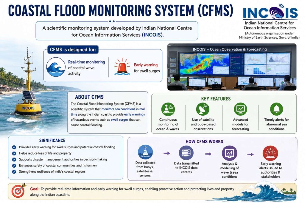
Indian National Centre for Ocean Information Services (INCOIS) has installed a second Coastal Flood Monitoring System (CFMS) near Kollam Harbour to improve forecasting of ‘Kallakkadal’ or swell surge events along India’s southwest coast.
What is ‘Kallakkadal’?
- “Kallakkadal” is a Malayalam term meaning: “Sea that comes stealthily”
- It refers to:
- Sudden high-energy swell surges
- Coastal flooding without local storms or rainfall
Purpose
- Improve accuracy of coastal flood forecasts
- Study nearshore wave transformation
- Build better early warning systems
About Coastal Flood Monitoring System (CFMS)
- A scientific monitoring system developed by Indian National Centre for Ocean Information Services for:
- Real-time monitoring of coastal wave activity
- Early warning for swell surges
Components of CFMS
- The system integrates:
- Coastal Automatic Weather Station
- Four high-frequency pressure sensors
- Installed at: Shallow depths of 3 to 7 metres
Why Kollam?
- Kollam Harbour was selected because:
- Kerala’s southwest coast frequently experiences swell surges
- Fishing communities are highly vulnerable
[2017] At one of the place in India, if you stand on the seashore and watch the sea, ‘you will find that the sea water recedes from the shore line a few kilometers and comes back to the shore, twice a day, and you can actually walk on the seafloor when the water recedes. This unique phenomenon is seen at
a. Bhavnagar
b. Bheemunipatnam
c. Chandipur
d. Nagapattinam