đŸ’„Join UPSC 2027,2028 Mentorship (July Batch) + XFactor Notes & Microthemes PDF

Subject: Geography

  • Boreal Summer Intra-Seasonal Oscillation (BSISO)

    Researchers at the Indian National Centre for Ocean Information Services (INCOIS), Hyderabad have reportedly found a way to better forecast the Boreal Summer Intra-Seasonal Oscillation (BSISO).

    Try this PYQ:

    Q.With reference to ‘Indian Ocean Dipole (IOD)’ sometimes mentioned in the news while forecasting Indian monsoon, which of the following statements is/are correct? (CSP 2017)

    1. IOD phenomenon is characterized by a difference in sea surface temperature between tropical Western Indian Ocean and tropical Eastern Pacific Ocean.
    2. An IOD phenomenon can influence an El Nino’s impact on the monsoon.

    Select the correct answer using the code given below:

    (a) 1 only

    (b) 2 only

    (c) Both 1 and 2

    (d) Neither 1 nor 2

    What is BSISO?

    • The BSISO of the Asian summer monsoon (ASM) is one of the most prominent sources of short-term climate variability in the global monsoon system.
    • It is the movement of convection (heat) from the Indian Ocean to the western Pacific Ocean roughly every 10-50 days during the monsoon (June-September).
    • Compared with the related Madden-Julian Oscillation (MJO) it is more complex in nature, with prominent northward propagation and variability extending much further from the equator.
    • It represents the monsoon’s ‘active’ and ‘break’ periods, in which weeks of heavy rainfall give way to brilliant sunshine before starting all over again.
    • The active phase also enhances monsoon winds and hence the surface waves.

    Why predict BSISO behaviour?

    • Some phases of boreal summer intraseasonal oscillation or BSISO induce high wave activity in the north Indian Ocean and the Arabian Sea, the researchers claimed.
    • Wave forecast advisories based on the BSISO would be more useful for efficient coastal and marine management.
    • This finding has a great significance in developing seasonal and climate forecast service for waves and coastal erosion for India.
  • Ammonium Nitrate:  Behind the massive explosion in Beirut

    The catastrophic explosion at Beirut port, Lebanon caused by the blast of over 2,700 tonnes of ammonium nitrate, has rocked the world.

    Practice question:

    Q. Despite a robust policy framework governing the hazardous chemicals in India, the recent gas leakage incident in Vizag highlights India’s unaddressed vulnerability to chemical disasters. Critically comment.

    What is Ammonium Nitrate?

    • In its pure form, ammonium nitrate (NH4NO3) is a white, crystalline chemical which is soluble in water.
    • A common chemical ingredient of agricultural fertilizers, the nitrogen-rich compound is also the main component of the explosive composition known as ANFO — ammonium nitrate fuel oil.
    • It is the main ingredient in the manufacture of commercial explosives used in mining and construction.
    • Many Improvised Explosive Devices (IEDs) used by terrorists around the world have ANFO as the main explosive, triggered by primary explosives like RDX or TNT.
    • In the majority of terror attacks in India, ammonium nitrate has been used along with initiator explosives like RDX.

    Ammonium nitrate as an explosive

    • Pure ammonium nitrate is not an explosive on its own.
    • It is classified as an oxidiser (Grade 5.1) under the UN classification of dangerous goods.
    • If mixed with ingredients like fuel or some other contaminants, or because of some other external factors, it can be very explosive.

    Stored ammonium nitrate is a major fire hazard

    • Large quantities of stored ammonium nitrate are regarded as a major fire hazard, with multiple reported cases across the world.
    • The explosion of large storage can happen primarily in two ways.
    • One is by some type of detonation or initiation because the storage comes in contact with the explosive mixture.
    • Second, the blast can result due to a fire which starts in the ammonium nitrate store because of the heat generated due to the oxidation process at large scale.

    Regulations in India about ammonium nitrate

    • Because it is used as an ingredient for the production of explosives, anaesthetic gases, fertilizers, cold packs and has a possibility of misuse, it is highly regulated in India.
    • There exists the Ammonium Nitrate Rules, 2012, under The Explosives Act, 1884.
    • It defines ammonium nitrate as the compound with formula NH4NO3 including any mixture or compound having more than 45 per cent ammonium nitrate by weight.
    • The manufacture, conversion, bagging, import, export, transport, possession for sale or use of ammonium nitrate is covered under The Ammonium Nitrate Rules, 2012.
    • The rules also make storage of ammonium nitrate in large quantities in populated areas illegal in India.
    • For the manufacture of ammonium nitrate, an Industrial licence is required under the Industrial Development and Regulation Act, 1951.
  • In news: Galapagos Islands

    Chinese ships are frequently entering Ecuador’s waters for commercial fishing near the Galapagos Islands.

    Try this question from CSP 2018:

    Q.Which one of the following can one comes across if one travels through the Strait of Malacca?

    (a) Bali

    (b) Brunei

    (c) Java

    (d) Singapore

    The Galapagos Islands

    • Renowned worldwide for its unique species, the islands host a wide array of aquatic wildlife, including marine iguanas, fur seals, and waved albatrosses.
    • The giant tortoises found here – ‘GalĂĄpagos’ in old Spanish– give the islands its name.
    • Ecuador made a part of the Galapagos a wildlife sanctuary in 1935, and the sanctuary became the Galapagos National Park in 1959.
    • In 1978, the islands became UNESCO’s first World Heritage Site.
    • It was here that the British naturalist Charles Darwin made key observations in 1835 that shaped his theory of evolution. Darwin described the islands as a “world in itself”.
  • [pib] Tuting-Tidding Suture Zone (TTSZ)

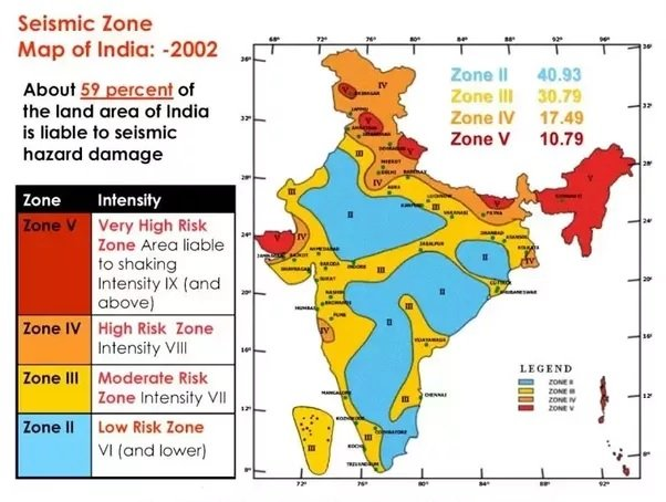
    Earthquake prone zones in India:

  • What is Seismic Noise?

    The seismic noise level has dropped by as much as 50 per cent between March and May due to lockdowns this year, according to researchers.

    Ever heard of space-based monitoring of seismic activities?  This topic creates a scope for potential prelims question


    What is Seismic Noise?

    • Seismic noise refers to vibrations within the Earth, which are triggered by natural and man-made phenomena like earthquakes, volcanoes and bombs.
    • Seismometers, specialised devices that record ground motions, also capture seismic noise.
    • Everyday human activity — such as road traffic, manufacturing in factories, the sound produced by planes roaring overhead, or simply people walking down the street.
    • The sound signals created by human beings are often referred to as anthropogenic seismic noise.
    • Seismic noise acts almost like background sound for seismologists — it is the unwanted component of signals recorded by a seismometer.

    Variations in noise levels

    • The level of anthropogenic seismic noise recorded varies based on a number of factors.
    • Highly-populated urban areas will generate more vibrations from human activity than less densely populated regions.
    • Timing too plays an important role. The degree of seismic noise is found to be much lower during public holidays.

    Why is this important to record this noise?

    • Due to this, scientists will be able to spot weaker signals.
    • Such small signals tell us about a geological fault making seismic hazard assessment more accurate.
    • This means that scientists will have a better shot at monitoring a whole range of seismogenic behaviour, including the smallest earthquakes or the early signs of a volcanic eruption.
  • [pib] Ravines of Chambal-Gwalior Region

    Union Minister of Agriculture & Farmers’ Welfare held a meeting with World Bank representatives to bring large Ravines of Gwalior–Chambal region under agriculture.

    Try this question for mains:

    Q.What is Badland Topography? Discuss the scope of their utilization as arable land in India.

    What are Ravines?

    • Badland topography is a major feature of the Chambal valley is characterized by an undulating floodplain, gullies and ravines.
    • Ravines are a type of fluvial erosional feature and are formed as a result of constant vertical erosion by streams and rivers flowing over semi-arid and arid regions.

    How are they formed?

    • Researchers consider the regional climate as a major factor in the formation of ravines.
    • Climate indeed plays a huge role by supplying the water in the form of rain or snow as well as providing the temperature variations.
    • However, the ravines of Chambal are a bit difficult to be explained solely on climatic terms.
    • The region through which the Chambal River flows does not receive enough rainfall to create ravines that are 60–80 m deep.
    • Researchers have attributed neotectonic activities to the Chambal ravines genesis.

    Other factors

    • It is well known that rivers are full of energy and actively erode in their initial phases and progressively become passive as they attain their base levels.
    • But sometimes, due to tectonic movements, the base level may be lowered further thus energizing the river and reactivating the erosion. This is known as River Rejuvenation.
    • Moreover, wind erosion has also contributed to the formation of Chambal ravines.

    Back2Basics: What are Badlands?

    • Badlands are erosional landforms of highly dissected morphology that are created on soft bedrock in a variety of climate conditions.
    • They develop in arid to semiarid areas where the bedrock is poorly cemented and rainfall is generally heavy and intermittent.
    • The dry, granular surface material and light vegetation are swept from the slopes during showers, leaving the gullies bare.
  • Lonar Lake turned pink due to ‘Haloarchaea’ microbes

    The colour of Lonar lake water in Maharashtra’s Buldhana district turned pink due to a large presence of the salt-loving ‘Haloarchaea’ microbes, a probe carried out by a Pune-based institute has concluded.

    Make a note of all saltwater lakes in India. Few of them are Pulicat, Pangong Tso, Chilika, and Sambhar Lakes etc.

    Haloarchaea’ microbes

    • Haloarchaea or halophilic archaea is a bacteria culture which produces pink pigment and is found in water saturated with salt.
    • The increased salinity and pH facilitated the growth of halophilic microbes, mainly Haloarchaea.
    • Basically, it is the biomass of these microbes and because of that, the surface of the water turned red or pink and as soon as the biomass subsided, the colour disappeared.
    • The scientist said the colour of the lake is now returning to original as the rainy season has kicked in, allowing dilution of the water.
    • Initially, it was thought for the red-pigmented Dunaliella algae due to which the water might have turned pink.
    • Because of that, the salinity and pH/alkalinity levels have also come down and green algae have started growing in the water body.

    About Lonar Lake

    • Lonar Lake, also known as Lonar crater, is a notified National Geo-heritage Monument, saline (pH of 10.5), Soda Lake, located at Lonar in Buldhana district, Maharashtra.
    • It was created by an asteroid collision with earth impact during the Pleistocene Epoch.
    • It is one of the four known, hyper-velocity, impact craters in basaltic rock anywhere on Earth.
    • It sits inside the Deccan Plateau—a massive plain of volcanic basalt rock created by eruptions some 65 million years ago.
    • Its location in this basalt field suggested to some geologists that it was a volcanic crater.
  • National Flood Commission

    At least 43 years after India’s first and last commission on floods was constituted, there is no national-level flood control authority in the country so far.

    Try this question for mains:
    Q. What are the various causes of urban floods in India?

    National Flood Commission

    • Rashtriya Barh Ayog or the National Flood Commission (NFC) was set up by the Ministry of Agriculture and Irrigation in 1976.
    • It aimed to study India’s flood-control measures after the projects launched under the National Flood Control Programme of 1954 failed to achieve much success.

    NFCs recommendation

    • In 1980, the NFC made 207 recommendations and four broad observations:
    • First, it said there was no increase in rainfall in India and, thus, the increase in floods was due to anthropogenic factors such as deforestation, drainage congestion and badly planned development works.
    • Second, it questioned the effectiveness of the methods adopted to control floods, such as embankments and reservoirs, and suggested that the construction of these structures be halted until their efficacy was assessed.
    • Third, it said there have to be consolidated efforts among the states and the Centre to take up research and policy initiatives to control floods.
    • Fourth, it recommended a dynamic strategy to cope with the changing nature of floods. An analysis of the report suggested that the problem began with the methods of estimating flood-prone areas of the country.

    Why revive NFC?

    • An accurate estimate is crucial for framing flood management programmes.
    • The NFC estimated that the total area vulnerable to floods in 1980 was around 40 million hectares.
    • There is another problem. The very definition of the flood-prone area does not reflect the effectiveness of the flood management works undertaken.
  • ‘Churachandpur Mao Fault’ in Mizoram

    Mizoram’s zone of “scary” earthquakes is caught between two subterranean faults called the ‘Churachandpur Mao Fault’.

    Try this question from CSE Mains 2014:

    Q.Why are the world’s fold mountain systems located along the margins of continents? Bring out the association between the global distribution of Fold Mountains and the earthquakes and volcanoes.

    Churachandpur-Mao Fault (CMF)

    • The CMF is named after two places in Manipur and runs north-south into Myanmar along the border of Champhai.
    • The Mat Fault runs northwest-southeast across Mizoram, beneath river Mat near Serchhip.
    • It is defined by straight valleys; most prominent being between Kangpokpi and Maram region of Mizoram.
    • The fault takes a north-easterly trend from Maram where the fault zone is characterized by active landslides during the monsoon.

    Why study CMF?

    • Faults are discontinuities or cracks that are the result of differential motion within the earth’s crust.
    • Vertical or lateral slippage of the crust along the faults causes an earthquake.
  • Rapid Intensification of Cyclones

    Tropical cyclones remain the deadliest natural climate hazard that causes an unacceptably high loss of life, property and infrastructure.  Global warming has already resulted in a detectable increase in the number of higher intensity cyclones as well as their intensification.

    Also read:

    [Burning Issue] Tropical Cyclones and India

    Try this question:

    Q. The Marsupial Theory often seen in news is related to which of the climatic phenomena?

    a) Heatwaves b) Monsoon Variability c) Formation of Cyclones d) Thunderstorms

    What is Rapid Intensification of Cyclones?

    • RI is defined as an increase in maximum sustained winds by at least 55 km/hour in a 24-hour period.
    • Such acceleration can only come with a rapid drop in the pressure in the eye of the cyclone.
    • Rapid intensification (RI) is making cyclone forecasts harder and intense cyclones with RI are expected to grow in number.
    • The lack of understanding of the transition from a seedling of a cyclone, like a low-pressure system to a tropical storm, limits extending the forecast lead times.

    Factors causing RI

    The most important environmental factors for cyclone genesis are-

    • the rotation or vorticity of a low-pressure system at the surface;
    • sea surface temperatures or the volume of warm water available;
    • the vertical motion of air in this low-pressure system;
    • the amount of humidity available in the middle atmosphere and
    • the vertical shear or the change in winds from the surface to the upper atmosphere.

    MJO and Cyclones

    • Madden-Julian Oscillations as they are known, dominate the tropics during October-April by propagating from the western Indian Ocean into the eastern Indian Ocean, across the Indonesian seas into the Pacific Ocean.
    • Referred to as MJOs, these Madden-Julian Oscillations throw seeds of rotational low-pressure systems over the Indian and the Pacific Oceans.
    • And thus, MJOs show a strong association with cyclogenesis, especially for the post-monsoon season.

    Impacts of MISO

    • Monsoon Intraseasonal Oscillations (MISO) are alternating periods of heavy and minimal rainfall, each lasting for about a month or so and tending to follow a cyclical, northward shifting pattern from the equator to southern Asia.
    • While the strong vertical shear suppresses cyclones during the monsoon season, MISOs influence cyclone genesis during the pre-monsoon season.

    Other factors

    • At longer timescales, phenomena like the El Niño and La Niña influence not only the number of cyclone seeds but also the location and the expanse of warm water.
    • For example, during the pre-monsoon season of La Niña year, the region of warm water over the Bay of Bengal increases. This leads cyclones to travel longer and grow stronger than during an El Niño year.
    • Over the Pacific Ocean, on the other hand, it is the El Niño that provides a larger swath of warm water and more intense cyclones.
    • West Africa produces waves called easterly waves that propagate west from land onto the tropical Atlantic Ocean and sow the seeds for most hurricanes.
    • Extensive analysis has produced theories that are evocatively called the Marsupial Theory — a wave pouch that allows cyclones to grow, or waves interacting to produce a Kelvin cat’s eye, which is a ‘sweet-spot’ for the birth of a cyclone.