💥Join UPSC 2027,2028 Mentorship (August Batch) + XFactor Notes & Microthemes PDF

Subject: Space Technology

  • What is the Air Drop Test (ADT-1) conducted by ISRO?

    Why in the News?

    ISRO has successfully conducted IADT-1, a key milestone for India’s maiden human spaceflight mission, Gaganyaan.

    What is the Air Drop Test (ADT-1) conducted by ISRO?

    About Air Drop Test (ADT-1):

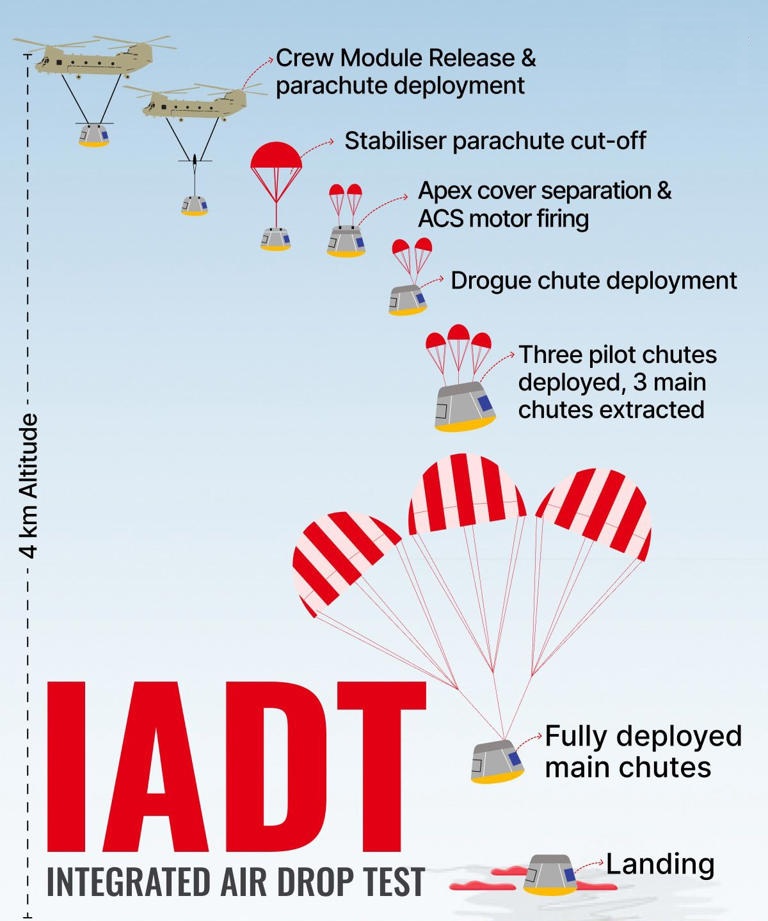
    • Test Setup: A dummy crew module weighing nearly 5 tonnes was dropped from an Indian Air Force Chinook helicopter at an altitude of about 3 km.
    • Purpose: To test the parachute-based deceleration system that will slow the crew module during re-entry and ensure a safe splashdown.
    • Parachute Sequence: Parachutes deployed in order — first drogue chutes, followed by three main parachutes — slowing the capsule to about 8 metres per second before landing.
    • Outcome: The touchdown matched expectations, successfully validating the design for human re-entry and landing.

    Roadmap for Gaganyaan:

    • Objective: The ultimate goal is to send Indian astronauts to low-earth orbit on a human-rated LVM3 rocket.
    • Validation Tests: A series of safety validation tests are planned before the crewed mission.
    • Crew Escape System (CES): Already tested with TV-D1 in October 2023; TV-D2 will demonstrate a more complex abort scenario.
    • First Uncrewed Mission (G1): Will carry the humanoid robot Vyommitra to simulate astronaut operations.
    • Parallel Trials: Multiple air drop tests and subsystem validations, including parachute trials and life-support system checks, will continue.
    • Key Technologies: Critical systems under development include the Environmental Control and Life Support System (ECLSS), the Integrated Vehicle Health Management System (IVHMS), and a strengthened human-rated LVM3 rocket.
    • Timeline: The first human spaceflight (H1) is currently targeted for 2027, though delays are possible due to complexity in human-rating systems.

    Long-term Goals:

    • Foundation: Gaganyaan marks the beginning of India’s long-term human spaceflight programme.
    • Space Station: The GoI has announced the Bharatiya Antariksh Station (BAS) to be established by 2035.
    • Lunar Mission: India aims to achieve a crewed lunar landing by 2040.
    • Critical Technologies: Capabilities such as in-orbit docking, demonstrated by the SpaDeX mission in 2025, will be essential for future missions.
    [UPSC 2025] Consider the following space missions:

    I. Axiom-4 II. SpaDeX III. Gaganyaan

    How many of the space missions given above encourage and support microgravity research?

    Options:

    (a) Only one (b) Only two (c) All the three* (d) None


  • Lunar Module Launch Vehicle (LMLV)

    Why in the News?

    The Indian Space Research Organisation (ISRO) is developing its heaviest-ever rocket, the Lunar Module Launch Vehicle (LMLV).

    About Lunar Module Launch Vehicle (LMLV):

    • Overview: India’s heaviest rocket under development by the Indian Space Research Organisation (ISRO).
    • Purpose: Designed mainly for lunar exploration, including India’s first human mission to the Moon by 2040.
    • Strategic Role: Replaces the Next Generation Launch Vehicle (NGLV) plan and will support India’s space station programme.
    • Scale: As tall as a 40-storey building, far larger than the current LVM-3.

    Key Features:

    • Payload Capacity: Can carry 80 tonnes to Low Earth Orbit (LEO) and 27 tonnes to the Moon, suitable for human-rated spacecraft.
    • Three-stage: Partially reusable super heavy-lift vehicle with:
      • First two stages using liquid propellants.
      • Third stage using cryogenic propellant.
      • Strap-on boosters taller than the entire LVM-3 rocket.
      • 27 engines in the first stage (core + boosters).
    • Timeline: Expected completion by 2035.
    • Indigenous Development: Conceived by ISRO within months; aligned with India’s long-term space exploration goals.

    Future Missions based on LMLV:

    • Human Lunar Mission (2040 target): Capable of carrying 18–20 tonne crew modules for India’s first astronaut landing on the Moon.
    • Bharatiya Antariksh Station (BAS): Will deploy heavy modules for India’s planned five-module space station by 2035.
    • Lunar Cargo Missions: Can transport ~27 tonnes to the Moon, supporting logistics and lunar infrastructure.
    • Deep Space Exploration: Its heavy-lift capacity could enable interplanetary missions in the 2040s, extending beyond lunar exploration.
    [UPSC 2018] With reference to India’s satellite launch vehicles, consider the following statements:

    1.PSLVs launch the satellites useful for Earth resources monitoring whereas GSLVs are designed mainly to launch communication satellites.

    2.Satellites launched by PSLV appear to remain permanently fixed in the same position in the sky, as viewed from a particular location on Earth.

    3.GSLV Mk III is a four-stage launch vehicle with the first and third stages using solid rocket motors, and the second and fourth stages using liquid rocket engines.

    Which of the statements given above is/are correct?


    Options: (a) 1 only* (b) 2 and 3 (c) 1 and 2 (d) 3 only


  • Why India needs a national space law

    India is entering a new era of space exploration with  lunar success, Gaganyaan, and the proposed Bharat Antariksh Station. Yet, one critical element is missing, a national space law. While India has ratified global treaties like the Outer Space Treaty (1967), it lacks a domestic legal framework to regulate private participation, ensure liability, and attract investment. As space activities expand beyond government agencies to startups and private players, the absence of clear laws poses risks to accountability, innovation, and global competitiveness.

    The Urgency of a National Space Law

    1. Major milestone vs. missing law: India’s scientific achievements are unmatched, but the legal architecture remains absent, risking accountability gaps.
    2. Private participation: With startups entering, lack of clarity on licensing, FDI rules, liability, and insurance creates operational hurdles.
    3. International responsibility: Under the Outer Space Treaty, India is responsible for both governmental and private activities, yet it lacks the domestic framework to enforce compliance.
    4. Global contrast: Countries like the U.S., Japan, and Luxembourg already have national legislation that provides legal certainty and attracts investment.

    Principles of the Outer Space Treaty

    1. Foundational principles: Space is the province of all mankind, prohibiting national appropriation and militarisation.
    2. State responsibility: Nations are responsible for activities in space, whether by state or private entities.
    3. Liability framework: Countries bear liability for damages caused by their space objects.
    4. Not self-executing: According to UNOOSA, national laws are essential to translate treaty principles into enforceable domestic regulations.

    India’s Incremental Approach to Space Legislation

    1. Methodical strategy: India is incremental and cautious, ensuring technical regulations precede overarching law.
    2. Catalogue of Indian Standards: A framework to ensure safety of space operations.
    3. Indian Space Policy (ISP), 2023: Encourages non-governmental participation in space activities.
    4. IN-SPACe Norms, Guidelines and Procedures (NPG): Provide procedures for authorisation of space activities.
    5. Pending gap: The broader Space Activities Law that incorporates treaty obligations is still not enacted.

    Industry Concerns and Operational Challenges

    1. Statutory authority gap: IN-SPACe lacks formal legal backing, leaving decisions open to procedural challenges.
    2. Licensing and delays: Companies face multiple ministry clearances, creating uncertainty.
    3. FDI rules: Industry demands clarity, such as 100% automatic FDI in satellite components to attract capital.
    4. Liability and insurance: While India is internationally liable, companies need affordable third-party insurance to cover risks.
    5. Intellectual property protection: Current frameworks risk talent and tech migration to IP-friendly nations.
    6. Space debris management: Absence of mandatory accident investigations and debris laws increases operational risks.

    The Importance of Affordable Insurance for Space Startups

    1. High-value assets: Satellites and payloads involve massive investments; startups cannot absorb losses alone.
    2. Global liability: India bears responsibility internationally, so private players must secure third-party insurance.
    3. Investor confidence: Insurance frameworks encourage investors, reducing risk aversion.
    4. Innovation support: Affordable insurance ensures startups can experiment and grow, without fear of crippling liability.

    Conclusion

    India’s space programme has made historic strides, but without a comprehensive national space law, its progress risks being undermined by regulatory gaps. A forward-looking framework ensuring clarity, liability management, insurance, IP protection, and statutory backing for IN-SPACe is essential to balance innovation with responsibility. The future of India’s space leadership will depend as much on strong laws as on strong rockets.

    Value Addition

    • UNOOSA Insight: National laws act as the domestic enabler of international obligations. Without them, treaty principles remain unenforceable.
    • Comparative Perspective:
      • United States: Commercial Space Launch Act allows private launches with liability coverage.
      • Luxembourg: Pioneered space mining rights to attract global investors.
      • Japan: Provides licensing, insurance, and debris mitigation guidelines.
    • Governance Lens: Reflects the larger theme of state capacity to regulate frontier technologies, similar to how data protection laws govern digital economies.
    • Economic Angle: A robust legal framework will strengthen India’s space economy, valued at nearly $9.6 billion (2020) and projected to grow to $13 billion by 2025.
    • Investor Confidence: Insurance frameworks, clear FDI rules, and IP protection create a trustworthy ecosystem for global investors.
    • Security Dimension: Dual-use nature of space technologies necessitates clarity in export controls and defence linkages.
    • Ethical Dimension: Covers responsibility towards space debris management and sustainability of outer space as a global commons.

    Mapping Microthemes

    • GS Paper II (Governance, International Relations):
      • Outer Space Treaty (1967) – India’s obligations and global responsibility
      • Role of UNOOSA – multilateral governance of outer space
      • Need for National Legislation – predictability, legal clarity, statutory backing for IN-SPACe
    • GS Paper III (Science & Technology, Economy, Security):
      • Growth of India’s Space Economy – Chandrayaan-3, Gaganyaan, startups, private players
      • Insurance and Liability – affordability for startups, international responsibility for damages
      • Intellectual Property Rights – preventing brain drain, encouraging innovation
      • Space Debris Management – sustainability and accident investigation procedures
      • Dual-Use Technology Challenge – balancing civilian and defence aspects
    • GS Paper IV (Ethics & Governance):
      • Accountability in Outer Space – who bears liability for damage?
      • Ethics of Space Exploration – sustainability, “province of mankind” principle
      • Equitable Access – preventing monopolisation of space resources by few nations

    PYQ Relevance

    [UPSC 2016] Discuss India’s achievements in the field of Space Science and Technology. How the application of this technology has helped India in its socio-economic development?

    Linkage: While India’s space achievements like Chandrayaan-3 and Gaganyaan highlight scientific progress, the absence of a national space law shows a governance gap. A legal framework is crucial to translate these achievements into sustainable socio-economic gains through private participation, investment, and accountability.


  • MIT Research of Ionic Liquids (ILs)

    Why in the News?

    MIT-led research suggests life may not need liquid water; ionic liquids (salts that stay liquid below 100°C) could support life on rocky super-Earths with volcanic activity and little water.

    About Ionic Liquids (ILs):

    • Overview: Salts in liquid form below 100°C, composed entirely of ions.
    • Properties: Non-volatile, non-flammable, thermally stable, and tunable as hydrophobic or hydrophilic.
    • Structure: Unlike water (neutral molecules), ILs consist of ions and ion pairs.
    • Electrochemical Use: Excellent electrolytes with broad electrochemical windows.
    • Applications: Used in synthesis, catalysis, electrochemistry, extraction, biotechnology, and as green alternatives to volatile solvents.

    Breakthrough Findings of MIT Study:

    • Life Without Water: Experiments showed life could potentially survive using ILs as solvents instead of water.
    • Natural Formation: Sulfuric acid mixed with nitrogen compounds can naturally form ILs.
    • Exoplanet Link: Such ILs may exist on rocky super-Earths with volcanic activity and thin atmospheres.
    • Venus Research Origin: Discovery emerged from studying Venus, where sulfuric acid clouds interact with organic molecules to form ILs.
    • Biological Relevance: ILs can provide stable environments for biomolecules, supporting metabolism.

    Significance of the Study:

    • Habitability Expansion: Broadens habitability definition beyond water-based models.
    • Biosignatures: Suggests new chemical markers for exoplanet life detection.
    • Venus Missions: Strengthens rationale for Venus’s exploration targeting IL-based chemistry.
    • Wider Habitable Zones: Implies more planets could host life than previously thought.
    [UPSC 2015] The term ‘Goldilocks Zone’ is often seen in the news in the context of:

    (a) the limits of habitable zone above the surface of the Earth

    (b) regions inside the Earth where shale gas is available

    (c) search for the Earth-like planets in outer space*

    (d) search for meteorites containing precious metals


  • Orbiting Carbon Observatories (OCO) Program

    Why in the News?

    The Trump administration seeks to end two NASA missions under the Orbiting Carbon Observatories (OCO) program, which monitor global carbon dioxide emissions and plant health.

    About Orbiting Carbon Observatories (OCO) Program:

    • Overview: A NASA Earth remote sensing initiative dedicated to monitoring atmospheric carbon dioxide (CO) from space.
    • Objective: Designed to enhance understanding of climate change by precisely tracking CO₂ sources and sinks.
    • Comprises three missions:
      • OCO-1: Launched in 2009 but failed shortly after launch.
      • OCO-2: Launched in July 2014 as a replacement.
      • OCO-3: Installed on the International Space Station in May 2019.

    Key Features:

    • Precision Measurement: Provides high-resolution global CO₂ data and maps of plant photosynthesis.
    • Dual Capability: Measures CO₂ levels and solar-induced chlorophyll fluorescence to assess photosynthesis.
    • Applications: Detects drought, forecasts food shortages, identifies carbon sinks/sources, supports crop planning.
    • Global Reach: Tracks CO₂ distribution over continents, oceans, and remote ecosystems like Amazon and boreal forests.
    • Major Discoveries: Amazon rainforest now emits more CO₂ than it absorbs; boreal forests identified as major carbon sinks.
    • Policy Relevance: Supplies key data for climate treaties and greenhouse gas reporting.
    [UPSC 2019] For the measurement/estimation of which of the following are satellite images/remote sensing data used?

    1. Chlorophyll content in the vegetation of a specific location

    2. Greenhouse gas emissions from rice paddies of a specific location

    3. Land surface temperatures of a specific location

    Select the correct answer using the code given below.

    Options: (a) 1 only (b) 2 and 3 only (c) 3 only (d) 1, 2 and 3*


  • How does satellite internet work?

    Why in the News:

    Elon Musk’s Starlink will soon launch in India, promising high-speed internet access in regions beyond the reach of ground-based networks. This is significant as it can bridge rural-urban gaps, improve disaster resilience, and strengthen defence capabilities. Globally, satellite internet has been a lifeline during Hurricane Harvey and a tactical tool in the Russia-Ukraine war. For India, it represents both a technological leap and a strategic necessity.
    Introduction:

    In today’s digitised and interconnected world, internet access is as vital as electricity or transport. Traditional cable and tower-based networks excel in cities but falter in remote terrains. Satellite internet, powered by mega-constellations like Starlink, offers a borderless, high-resilience alternative that operates irrespective of geography.

    Why are ground-based internet networks economically unviable in certain regions?

    1. Physical Infrastructure Limits: Cables and towers are uneconomical for sparsely populated or remote regions
    2. Disaster Vulnerability: Infrastructure can be wiped out during floods, earthquakes, or storms
    3. On-the-Go Connectivity Gap: Mobile and temporary operations (airplanes, ships, oil rigs) often remain underserved

    How does satellite internet overcome these challenges?

    1. Global Coverage: Operates regardless of terrain or terrestrial infrastructure
    2. Rapid Deployment: Can be set up quickly to meet sudden demand surges
    3. Mobility Advantage: Supports moving platforms and remote sites
    4. Dual-Use Potential: Functions for both civil and military purposes (e.g., Ukrainian defence, Siachen Glacier operations)

    What makes the new wave of satellite internet significant?

    1. Mega-Constellations: Networks like Starlink have thousands of satellites in Low Earth Orbit (LEO)
    2. Disaster Response Role: Viasat aided Hurricane Harvey operations when 70% of cell towers failed.
    3. Defence Integration: Ukrainian drones fitted with Starlink to bypass Russian jamming; Indian Army use in high-altitude conflict zones
    4. Security Concerns: Smuggled Starlink devices used by insurgent groups and drug cartels

    Working of satellite internet:

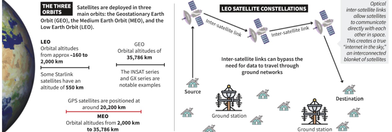
    1. Two Segments: Space segment (satellites) and ground segment (user terminals, gateways).
    2. Service Life: Satellites operate for 5–20 years depending on design.
    3. Orbits:
      1. GEO (35,786 km): Wide coverage, high latency; unsuitable for real-time apps. Example: Viasat GX.
      2. MEO (2,000–35,786 km): Medium latency, requires constellations. Example: O3b.
      3. LEO (<2,000 km): Low latency, small coverage; requires mega-constellations. Example: Starlink’s 7,000+ satellites.

    Key Differences between satellites in GEO, MEO AND LEO:

    Feature Geostationary Earth Orbit (GEO) Medium Earth Orbit (MEO) Low Earth Orbit (LEO)
    Altitude 35,786 km above equator 2,000 – 35,786 km Below 2,000 km
    Relative Motion Stationary relative to a point on Earth Moves relative to Earth Moves quickly relative to Earth
    Coverage ~1/3 of Earth (no polar coverage) Larger than LEO, smaller than GEO; needs constellation for global coverage Small footprint; single satellite covers area like an Indian metro city
    Satellite Size Large Large Smaller, often table-sized
    Cost & Deployment Expensive, long deployment Expensive, smaller constellations Cheaper, quicker to deploy
    Latency High (unsuitable for time-sensitive apps) Medium (lower than GEO but still limits real-time use) Very low (good for real-time use)
    Example Viasat Global Xpress (GX) O3b constellation (20 satellites) Starlink (7,000+ satellites, aiming for 42,000)
    Key Drawback High delay due to distance Still costly, latency not ideal for all uses Needs thousands of satellites for global coverage

    How do LEO mega-constellations maintain connectivity?

    1. On-Board Processing: Improves efficiency and reduces terminal complexity
    2. Optical Inter-Satellite Links: Satellites communicate directly in space for faster routing
    3. Seamless Handoff: Steerable antennas track multiple satellites to maintain uninterrupted service

    What are the key applications of satellite internet?

    1. Civil Connectivity: Rural broadband, IoE (Internet of Everything)
    2. Transportation: Navigation, self-driving cars, logistics optimisation
    3. Public Administration: Smart cities, disaster warnings, rescue coordination
    4. Healthcare: Telemedicine, remote diagnostics
    5. Agriculture: Precision farming, crop health monitoring
    6. Defence & Security: Real-time communication in conflict zones, strategic surveillance

    Conclusion

    Satellite internet represents not just a technological upgrade but a strategic asset in the digital era. For India, it offers a pathway to bridge the digital divide, enhance national resilience, and project influence in the global communications domain. However, its dual-use nature demands strong regulatory frameworks to balance innovation, accessibility, and security.

    Value Addition

    Key Terms & Phrases Explained

    • Satellite Internet: A communication service where internet connectivity is provided through satellites orbiting the Earth, rather than terrestrial cables/towers. It enables access in remote, disaster-hit, or mobile scenarios.
    • Mega-Constellation: A large network of hundreds or thousands of satellites, often in Low Earth Orbit (LEO), working in coordination to provide continuous coverage. Example: Starlink (planned 42,000 satellites).
    • Latency: Time taken for a signal to travel from sender to receiver; critical for real-time applications like video conferencing or online gaming.
    • Optical Inter-Satellite Links (OISL): Laser-based connections between satellites, enabling direct space-to-space data transfer without routing through ground stations, reducing delays and congestion.
    • Dual-Use Technology: A technology with both civilian and military applications. In satellite internet, the same network can support remote learning and healthcare or battlefield communication and drone operations.
    • Digital Divide: The socio-economic gap between those with access to modern digital technologies (internet, computing) and those without.
    • International Telecommunication Union (ITU): A UN agency responsible for coordinating global telecom networks, including orbital slot and spectrum allocation for satellites.
    • On-Board Processing: Satellite’s ability to process data directly in orbit, improving signal quality, speed, and reducing complexity of user terminals.
    • Seamless Handoff: Automatic switching of user connection from one satellite to another as satellites move, ensuring uninterrupted service.
    • Internet of Everything (IoE): An extension of IoT where not only devices, but also data, processes, and people are interconnected via the internet.

    Mapping  Micro Themes

    Paper Macro Theme Micro Themes Sub-Micro / Example
    GS Paper III Types of Orbits GEO (Geostationary) INSAT series, GSAT satellites
    MEO (Medium Earth Orbit) O3b constellation for broadband
    LEO (Low Earth Orbit) Starlink, OneWeb
    GS Paper III Application in Navigation GNSS Variants GPS (USA), GLONASS (Russia), Galileo (EU), IRNSS/NavIC (India)
    LEO & MEO in Navigation Faster signals, better coverage
    GS Paper II Policy & Governance India’s Space Policy 2023 PPP in satellite communication
    International Coordination ITU spectrum allocation

    Practice Mains Question:

    Discuss the potential of satellite internet in bridging the digital divide in India. Examine the associated security and regulatory challenges.

    PYQ Linkage:

    [UPSC 2018] Why is the Indian Regional Navigational Satellite System [IRNSS] needed? How does it help in navigation? 

    Linkage: IRNSS (also called NavIC) is India’s indigenous satellite-based navigation system providing accurate position information over India and surrounding regions.

    Just like IRNSS uses satellites for positioning, satellite internet uses similar orbital infrastructure for data connectivity. Understanding satellite orbits, latency, and ground segments from this topic directly aids in explaining IRNSS’s working, advantages, and strategic value in navigation.


  • Human Outer Planet Exploration (HOPE)

    Why in the News?

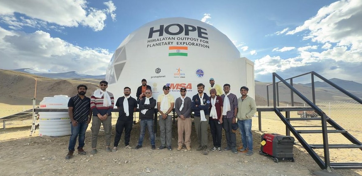
    India has taken a significant step towards interplanetary human missions with the launch of the Human Outer Planet Exploration (HOPE) analogue station at Tso Kar, Ladakh.

    hope

    About HOPE (Human Outer Planet Exploration):

    • Purpose: Simulates Moon and Mars conditions to prepare for future human missions.
    • Developer: Built by Protoplanet (Bengaluru); partially funded by ISRO.
    • Location: Tso Kar, Ladakh (14,500 ft) — chosen for its lunar/Martian-like terrain.
    • Features: Enables isolation research, tech trials, and crew training; 1 of 33 such stations globally.
    • First Mission (2025): Two scientists (Rahul Mogalapalli, Yaman Akot) conducted a 10-day simulation focusing on resilience and mental health.
    • Significance:
      • Boosts India’s human spaceflight readiness.
      • Supports goals like Bharatiya Antariksh Station (2035) and Moon mission (2040).

    India’s Astronomical Assets in Ladakh:

    • Location: Indian Astronomical Observatory (IAO), at Mt. Saraswati (4,500 m), Hanle; run by Indian Institute of Astrophysics.
    • Key Instruments:
      • Himalayan Chandra Telescope (optical/infrared)
      • HAGAR (gamma rays, with Tata Institute of Fundamental Research)
      • MACE (Cherenkov telescope, with Bhabha Atomic Research Centre)
    • Stargazing hubs: Hanle, Nubra Valley, Pangong, Tso Moriri.
    • Advantages & Recognition:
      • 270+ clear nights; low humidity; dark skies.
      • Declared India’s 1st Dark-Sky Reserve (2022) to curb light pollution.
    [UPSC 2012] The world’s highest ground based telescopic observatory is located in

    Options: (a) Colombia (b) India* (c) Nepal (d) Switzerland


  • NASA-ISRO Synthetic Aperture Radar (NISAR)

    Why in the News?

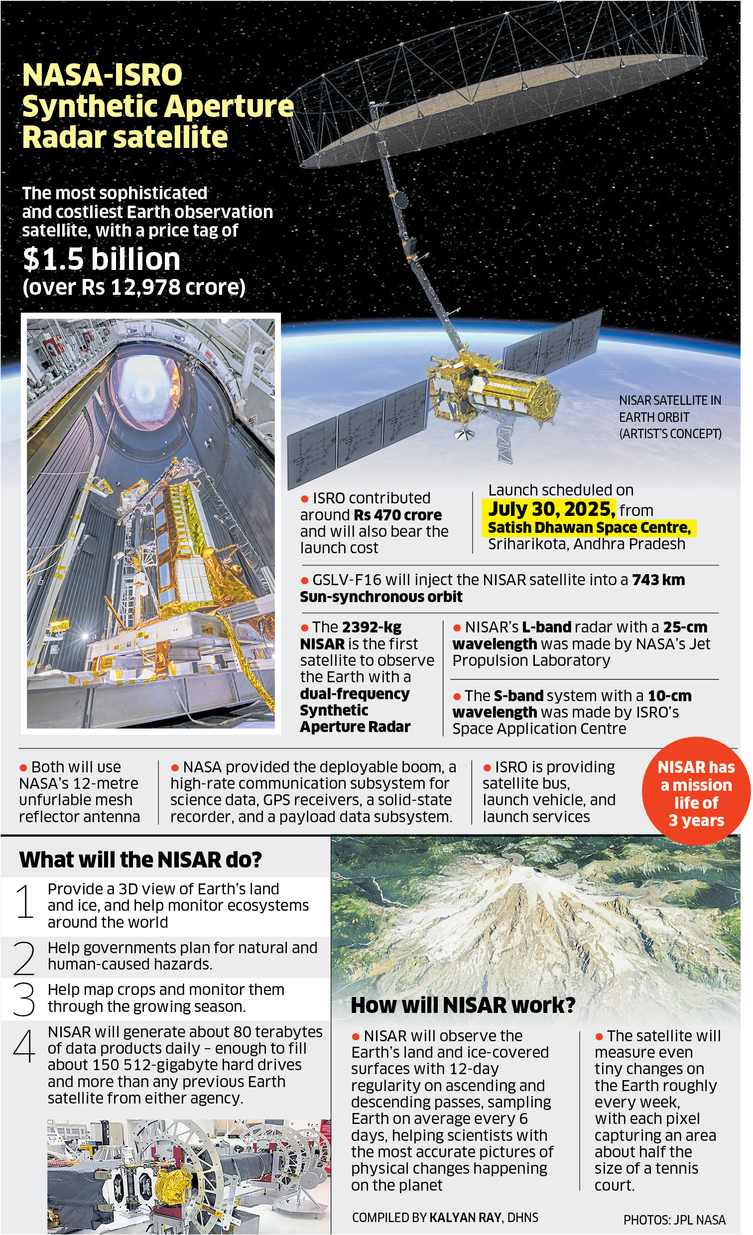
    The NASA-ISRO Synthetic Aperture Radar (NISAR) has been successfully launched from Sriharikota using GSLV Mk-II.

    NASA-ISRO Synthetic Aperture Radar (NISAR)

    About NISAR (NASA–ISRO Synthetic Aperture Radar):

    • Launch Vehicle: GSLV Mk-II | Launch Site: Sriharikota, India
    • Mission Life: 3 years (planned); 5+ years (design)
    • Orbit: Sun-synchronous polar orbit at 747 km with 98.4° inclination
    • Objective: High-precision monitoring of Earth’s surface changes—tectonics, agriculture, ecosystems, ice, floods, and landslides
    • Data Access: Free and near real-time; disaster maps delivered in under 5 hours
    • Hardware Contributions:
      • NASA: L-band SAR, 12m antenna, avionics
      • ISRO: S-band SAR, satellite bus, launch services
    • Development and Collaboration:
      • Initial Concept: 2007 (NASA); ISRO joined in 2012
      • Formal Agreement: 2014
      • Investment: NASA – ~$1.16 billion; ISRO – ~$90 million

    Key Features of NISAR:

    • What is Synthetic Aperture Radar (SAR)?
      • Operates day/night, all-weather
      • Simulates large radar antenna via motion
      • Penetrates clouds, vegetation, and soil
    • Dual-Band SAR:
      • L-band SAR (1.257 GHz):
        • Deeper penetration; ideal for forests, tectonic shifts, permafrost
      • S-band SAR (3.2 GHz):
        • Surface details; supports agriculture, flood mapping, biomass tracking
    • Radar Antenna:
      • 12-meter deployable mesh reflector
      • Resolution: 3–10 m spatial; cm-level vertical
      • Swath Width: 240 km
    • Imaging Frequency:
      • Global land/ice coverage every 12 days
      • Less frequent in polar zones
    • Data Output: Generates 80 TB/day (3x current Earth observatories):
      • Biomass and cropland maps
      • High-resolution flood and infrastructure data

    Applications and Impact:

    • Disaster Relief: Before-and-after imagery for planning
    • Climate Monitoring: Glacier melt, forest degradation
    • Agriculture: Crop health, rotation, food security
    • Infrastructure: Detects land subsidence (dams, cities)
    • Strategic Value:
      • Most powerful Earth-observing radar satellite
      • First with dual SAR payload
      • Strengthens India–US space partnership (Artemis, human spaceflight)
    [UPSC 2010] Question: In the context of space technology, what is Bhuvan, recently in the news ?

    Options: (a) A mini satellite launched by ISRO for promoting the distance education in India (b) The name given to the next Moon Impact Probe, for Chandrayaan-II (c) A geoportal of ISRO with 3D imaging capabilities of India* (d) A space telescope developed by  India


  • Planetary Formation observed around HOPS‑315 Star

    Why in the News?

    A study in Nature has provided the first observational evidence of solid rock forming from vapour in a distant star system HOPS-315, marking early planet formation.

    About HOPS-315:

    • Type: A young star system located in the Orion constellation.
    • Protoplanetary Disc: Surrounded by a flat, rotating disc of gas and dust, where new planets can form.
    • Orientation: The disc’s tilt offers a clear line of sight from Earth, allowing deep observation.
    • Observational Tools:

    Clue on New Planet Formation:

    • Rock Vapour Crystallisation: Scientists captured rock vapour cooling and forming crystals, marking the first direct observation of solid matter forming around a star.
    • Detected Elements:
      • Silicon monoxide gas at 470 Kelvin, close to the star.
      • Crystalline silicates such as forsterite, enstatite, and silica found within 2.2 astronomical units of the star.

    Scientific Significance:

    • Similarity to Earth: The crystallisation mimics processes found in primitive meteorites on Earth.
    • Chemical Confirmation: Suggests universal chemical processes in early planet formation across star systems.
    • Location of Minerals: Crystals were detected in the disc’s atmosphere, not in stellar outflows.
    • Temperature Conditions: Simulations confirmed dust vaporises and re-forms into solids at around 1300 Kelvin.
    • Formation Stage: Marks the earliest stage of rocky planet formation ever observed.
    [UPSC 2015] The term ‘Goldilocks Zone’ is often seen in the news in the context of-

    Options: (a) the limits of habitable zone above the surface of the Earth (b) regions inside the Earth where shale gas is available (c) search for the Earth-like planets in outer space* (d) search for meteorites containing precious metals


  • International Moon Day

    Why in the News?

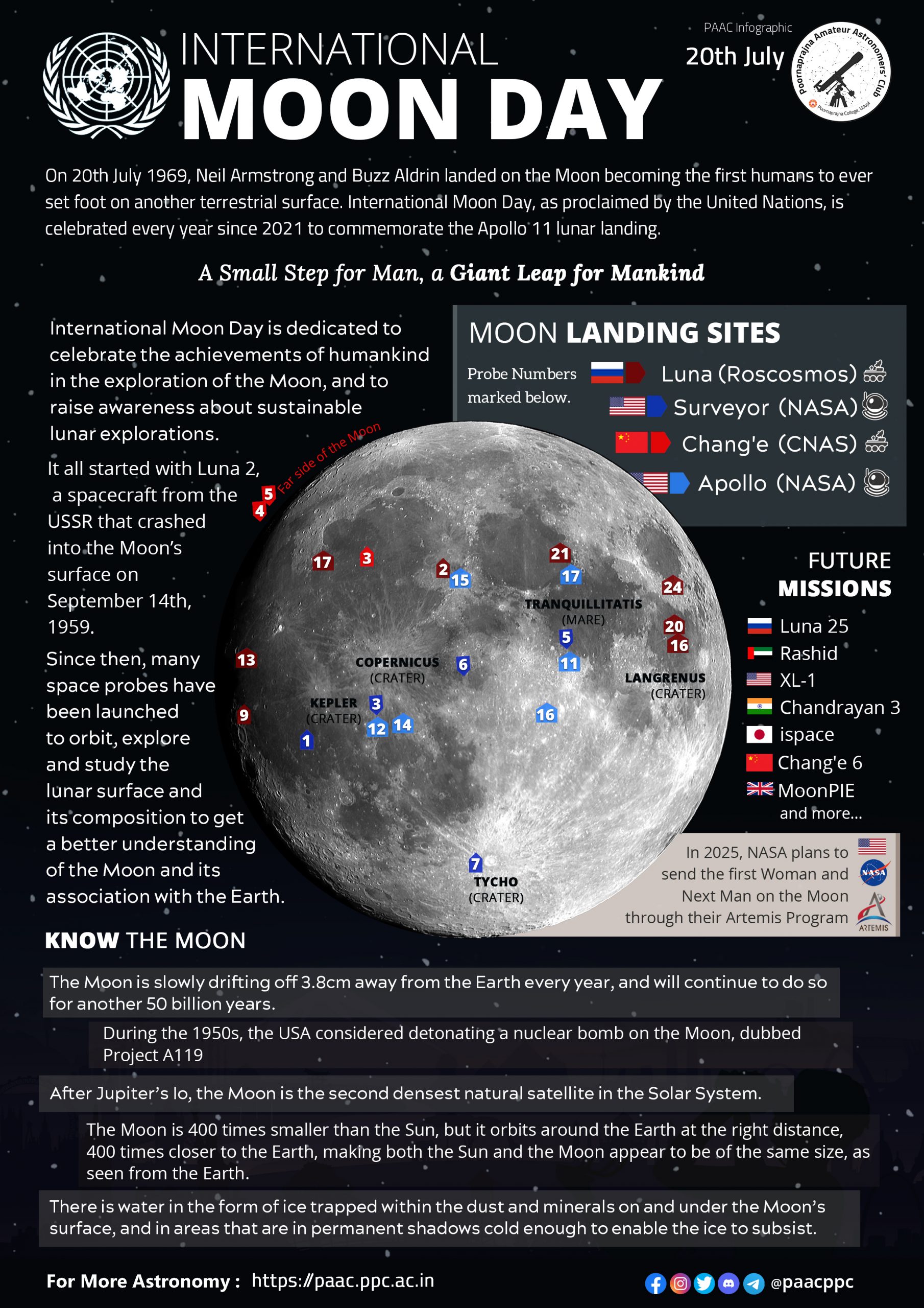
    Observed every year on July 20, the International Moon Day marks the historic first human landing on the Moon by the Apollo 11 mission in 1969.

    moon day

    About International Moon Day:

    • Date & Purpose: Observed annually on July 20 to mark the Apollo 11 Moon landing in 1969.
    • UN Recognition: Declared by the UN General Assembly in 2021 on the recommendation of COPUOS.
    • First Observance: Officially celebrated for the first time on July 20, 2022.
    • Activities: Includes sky-gazing, science outreach, and student competitions to promote space awareness.
    • Date Controversy: While the lunar module landed on July 20, Neil Armstrong stepped onto the Moon at 2:56 UTC on July 21—yet July 20 remains the official date.

    Significance:

    • Historic Milestone: Celebrates Apollo 11 and humanity’s first step on the Moon by Neil Armstrong and Buzz Aldrin.
    • Peaceful Space Use: Promotes the Moon as a shared heritage and fosters international cooperation in outer space.
    • Sustainability Focus: Encourages responsible and eco-friendly exploration of lunar resources.
    • Global Unity: Reflects the UN’s vision of peaceful space collaboration under themes like “One Moon, One Vision, One Future”.
    [UPSC 2009] India has recently landed its Moon Impact Probe on the Moon. Among the following countries, which one landed such probe on the Moon earlier?

    Options: (a) Australia (b) Canada (c) China* (d) Japan