Q.1) N. Srikrishna committee is related to
a) Arbitration
b) Anti-Terrorism
c) Merger of Public Sector Banks
d) Divestment of Public Sector Units
Q.2) Which of the follwoing comprises ‘All India Services’? 1. Indian Administrative Service (IAS) 2. Indian Forest Service (IFoS) 3. Indian Police Service (IPS) 4. Indian Foreign Service(IFS) Select the correct option using the codes given below.
a) 1, 3 and 4 only
b) 1, 2, 3 and 4
c) 1 and 3 only
d) 1, 2 and 3 only
Q.3) Which of the following are the by-products of the Sugar Industry? 1. Molasses, 2. Beet pulp, 3. Bagasse fiber Select the correct option using the codes given below.
a) 1 and 2 only
b) 1, 2 and 3
c) 2 and 3 only
d) 1 and 3 only
Q.4) Which of the following statements regarding the term ‘Demographic dividend’ is correct?
a) It occurs when the proportion of working people in the total population is high.
b) It occurs when the proportion of Above Poverty Line people in the total population is high.
c) It is the division of population on the basis of resources available to them.
d) None of the above
Q.5) Consider the following statements regarding the Mandal Commission and the OBCs: 1. Mandal Commission was established in 1979. 2. There is no mention of OBCs in the Indian Constitution, at the time of its implementation. Which of the statements given above is/are correct?
a) Both are correct
b) 1 only
c) 2 only
d) Neither 1 nor 2
Q.6) The Genetic Engineering Appraisal Committee is constituted under the
a) Food Safety and Standards Act, 2006
b) Geographical Indications of Goods (Registration and Protection) Act, 1999
c) Environment (Protection) Act, 1986
d) Wildlife (Protection) Act, 1972
Q.7) In the Mekong-Ganga Cooperation, an initiative of six countries, which of the following is/are not a participant/ participants? 1. Bangladesh 2. Cambodia 3. China 4. Myanmar 5. Thailand Select the correct answer using the code given below.
a) 1 only
b) 2, 3 and 4
c) 1 and 3
d) 1, 2 and 5
Q.8) ‘Basel III Accord’ or simply ‘Basel III’, often seen in the news, seeks to
a) develop national strategies for the conservation and sustainable use of biological diversity
b) improve banking sector’s ability to deal with financial and economic stress and improve risk management
c) reduce the greenhouse gas emissions but places a heavier burden on developed countries
d) transfer technology from developed countries to poor countries to enable them to replace the use of chlorofluorocarbons in refrigeration with harmless chemicals
IMPORTANT STUFF:
1. Daily newscards have been enriched with back2basics and note2students – Make notes daily
Under cash crops, those commercial crops are included which are produced by farmers mainly to earn money. The cash crop is often not consumed by the farmer himself. Some important cash crops have been discussedbelow in detail:
1. Sugarcane
Geographical Conditions of Growth:
It is a tropical as well as sub-tropical crop.
Sugarcane in North India is of the sub-tropical variety and has low sugar content. Also sugar factories have to remain shut in winter seasons in North India. Also, sugarcane juice begins to dry up because of the long dry season in north India.
Sugarcane in South India is of the tropical variety and high sugar content and high yield.
It grows well in hot and humid climate with a temperature of 21°C to 27°C and an annual rainfall of 75-100cm.
Medium and heavy soils where irrigation facilities are available are ideal for its cultivation.
It can be grown on a variety of soils and needs manual labour from the time of sowing to harvesting.
It is a long maturing crop planted between February and April. Harvesting begins in October and November.
It is a soil-exhausting crop and thus needs regular application of manure or fertilisers.
Important Producing Areas:
India is considered the original homeland of sugarcane and has the largest area under sugarcane in the world.
India is the second largest producer of sugarcane only after Brazil.
The major sugarcane producing states are Uttar Pradesh, Maharashtra, Karnataka, Tamil Nadu, Andhra Pradesh, Bihar, Punjab and Haryana.
2. Cotton
India is believed to be the original home of the cotton plant.
It is also one of the most important industrial crops of India.
Geographical Conditions of Growth:
Cotton grows well in the drier parts of the black cotton soil of the Deccan plateau. It can also be grown on alluvial and red soils.
It requires high temperature (20-35°C), light rainfall (50 to 80cm) or irrigation, 210 frost free days and bright sunshine for its growth. Clear sky during the picking season is ideal.
It is a Kharif crop and requires 6-8 months to mature.
Important Producing Areas:
India is the fourth largest producer of cotton in the world. China, USA and Pakistan grow more cotton than India.
Cotton is cultivated in about 45% of the total sown area in the country.
The major cotton producing states are Maharashtra, Gujarat, Madhya Pradesh, Karnataka, Andhra Pradesh, Tamil Nadu, Punjab, Haryana and Uttar Pradesh.
Important Varieties: India produces both short staple (Indian) cotton and long staple (American) cotton. American Cotton is called ‘Narma’ in the north-western part of the country.
3. Jute
It is also known as the golden fibre and is India’s major cash crop.
Jute fibre is obtained from the inner bark of the jute plant.
It is used in making gunny bags, mats, ropes, yarn, carpets and other artefacts. Jute cultivation in India has recently suffered due to reduced demand as a result of increasing competition with artificial fibre and packaging material.
Geographical Conditions of Growth:
It is a soil-exhausting crop like sugarcane and lowers soil fertility rapidly. It thus grows well on the well drained fertile soils in the flood plains where the soils are renewed every year.
High temperatures (24°C to 35°C), heavy rain (125 – 200cm) and low plain land are favourable conditions for the cultivation of jute.
Important Producing Areas:
West Bengal (largest producer in India), Bihar, Assam, Orissa and Meghalaya.
India is the largest producer of jute in the world.
Important Varieties: Mesta
4. Tobacco
Tobacco was brought to India by the Portuguese.
Uses: Its leaves are used in making cigarettes, cigar, beedi etc. Its stem is used as potash fertilizer and its powder as an insecticide.
Geographical Conditions of Growth:
It requires temperatures of 15°C to 40°C and rainfall of about 50cm or irrigation facilities. More than 100cm of annual rainfall and frost is harmful for the crop.
Fertile soils with good drainage are ideal as it is an exhaustive crop
Important Producing Areas:
Gujarat, Andhra Pradesh, Karnataka, Tamil Nadu and Bihar.
More than 1/3rd tobacco of the country is produced by Andhra Pradesh alone.
Important Varieties: Nicotina Tabacum and Nicotina Rustics. Virginia tobacco used for making cigarettes and Dale Crest varieties are grown in Andhra Pradesh.
5. Oilseeds
Main oilseeds produced in India include groundnut, mustard, coconut, sesasmum (til), soyabean, castor seeds, linseed, and sunflower.
Uses – Most of these are edible and used as cooking mediums. Some of these are also used as a raw material in the production of soaps, ointments and cosmetics.
Geographical Conditions of Growth:
Most oilseeds are grown as dry crops or in association with other crops e.g. mustard is grown with wheat.
Important Producing Areas:
India is the largest producer of oilseeds in the world. About 20% of the world’s oilseed producing area is in India.
Different oilseeds are grown covering approximately 14% of the total cropped area of the country.
Major oilseed producing areas are the plateau of Malwa, Marathwara, Gujarat, dry areas of Rajasthan, Telangana and Rayalseema regions of Andhra Pradesh.
Madhya Pradesh ranks first (31%) in the total oilseeds production and is followed by Rajasthan and Gujarat.
The smaller oilseeds are grown mainly in the north (Gujarat, MP, Rajasthan, Punjab and Haryana) and the larger seeds in the south mainly Kerala, Tamil Nadu, Andhra Pradesh and Karnataka. A list of particular oilseeds and their producing states:
Coconuts – The southern coastal region in the states of Kerala, Tamil Nadu and Andhra Pradesh.
Castor seed – Gujarat
Linseed – Chhattisgarh
Soya beans – Madhya Pradesh
Mustard and rapeseeds – Rajasthan
Sunflower – Karnataka, Maharashtra and Andhra Pradesh
B. Important Plantation Crops
1. Tea
It is an important beverage crop introduced in India initially by the British.
Geographical Conditions of Growth and Production:
The tea plant grows well in tropical humid and subtropical humid climates endowed with deep and fertile well-drained soils, rich in humus and organic matter.
150cm summer rain and 21°C to 27°C daily temperature are needed for its cultivation.
Tea bushes require warm and frost-free climate all through the year.
Frequent showers evenly distributed over the year ensure continuous growth of the tender leaves.
Tea is often cultivated on the hill slopes so that there is no waterlogging in its roots.
Its leaves are to be plucked several times in a year, so availability of abundant and cheap labour is essential for its cultivation.
Important Producing Areas:
Assam, hills of Darjeeling and Jalpaiguri districts, West Bengal, Tamil Nadu and Kerala. Apart from these, Himachal Pradesh, Uttaranchal, Meghalaya, Andhra Pradesh and Tripura are also tea producing states in the country.
India is the leading producer as well as exporter of tea in the world. 28% tea of the world is produced here.
2. Coffee
Geographical Conditions of Growth:
Coffee is a tropical plantation crop.
16° – 28°C temperature, 150-250cm rainfall and well-drained slopes are essential for its growth.
It grows on hilly slopes at the height of 900-1800m.
Low temperature, frost, dry weather for a long time and harsh sunshine are harmful for its plants.
Coffee plants grow better in the laterite soils of Karnataka in India.
Important Producing Areas:
India contributes about 4% of the world’s total coffee production. It ranks 6th in the world in coffee production.
The coffee plant was grown for the first time on the Baba Budan Hills (Karnataka) in India.
At present, more than half of the total coffee production in India is produced by Karnataka alone, followed by Kerala and Tamil Nadu.
Important Varieties: The Arabica variety initially brought from Yemen is produced in the country.
Agriculture plays a vital role in India’s economy. 54.6% of the population is engaged in agriculture and allied activities (census 2011) and it contributes 17.4% to the country’s Gross Value Added. Besides, agriculture is an important source of raw material for industrial production and serves as a huge market for industrial products.
“It is in the agriculture sector that the battle for long term economic development will be won or lost.”- Gunnar Myrdal
Before we study this important sector, let’s look at some basic terms and statistics:
Some Important Terms and Statistics:
Total Geographical Area of India:
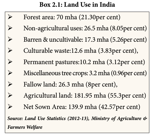
As per the land use statistics 2012-13, the total geographical area of the country is 328.7 million hectares. The latest figures of geographical area of the State/Union Territories are as provided by the Office of the Surveyor General of India.
Total Reporting Area for Land Utilisation Statistics:
The Reporting area stands for the area for which data on land use classification are available. As per the land use statistics 2012-13, the total reporting area is 305.9 million hectares. [Difference between the total geographical area and reporting area is on account of mapping issues due to difficult terrain + disputed land between India-Pak & India- China]
Net Sown Area:
This represents the total area sown with crops and orchards. The area sown more than once in the same year is counted only once.
Net Sown Area in India: 139.9 million hectares (42.57% of the total geographical area)
Gross Cropped Area
This represents the total area sown once and/or more than once in a particular year, i.e. the area is counted as many times as there are sowings in a year. This total area is also known as total cropped area or total area sown.
Gross Cropped Area in India: 194.4 million hectares (59.14% of the total geographical area)
Cropping Intensity
It is the ratio of the Total Cropped Area (or the gross cropped area) to the Net Area Sown.
Cropping Intensity in India = (Gross Cropped Area ÷Net Area Sown) * 100
= (194.4 ÷ 139.9) * 100
= 138.9%.
Therefore, more the use of arable land during a year more is the cropping intensity. Cropping Intensity depends on a number of factors:
Natural factors – More in areas with high temperatures and rainfall, cultivation is not possible in areas of cold climates/frost etc.
Socio-economic factors – Often the lands near towns have more cropping intensity because of higher demand of fruits, vegetables, flowers etc in urban areas.
Institutional Factors – Availability of irrigation facilities, good quality seeds, fertilizers etc also impacts the cropping intensity of a region. Eg. Higher cropping intensity in Punjab because of better infrastructural and institutional facilities.
Fallow land
Fallow land includes the land out of cultivation for one to five years.
Culturable Waste:
It includes the areas which can be brought under cultivation by efforts.
Determinants of Agriculture
The following factors determine the cropping pattern, yield of crops and overall agricultural development:
Physical factors – Topography, Climate and Soil
Institutional factors – Land holding size, land tenure
Agriculture is an age-old economic activity in our country. Over the years, cultivation methods have changed quite significantly depending on the above-mentioned factors. Farming varies from subsistence to commercial type.
Following are the 8 major farming systems practised in India:
Subsistence Farming
Shifting Agriculture
Plantation Agriculture
Intensive Farming
Dry Agriculture
Mixed and Multiple Agriculture
Crop-Rotation
Terrace Cultivation
To read about these farming systems in detail, click here!
Cropping Seasons in India:
India has the following three cropping seasons:
1. Rabi:
Rabi crops are sown in winter (from October to December) and harvested in summer (from April to June).
Major rabi crops are wheat, barley, gram, peas, mustard etc.
Though these crops are grown in large parts of India, states from the north and north-western parts such as Punjab, Haryana, Uttar Pradesh, Himachal Pradesh, Haryana, Jammu and Kashmir are important for the production of wheat and other rabi crops. This can be attributed to:
The availability of precipitation in the winter months due to the western temperate cyclones.
The success of green revolution in these areas.
2. Kharif:
Kharif crops are sown with the onset of monsoon in different parts of the country and are harvested in September to October.
The major Kharif crops are rice, jowar, bajra, maize, jute, groundnut, cotton, arhar, moong, urad, soyabean etc.
3. Zaid:
In between the rabi and Kharif seasons, there is a short season during the summer months known as the Zaid season.
Vegetables, watermelon, musk melon, cucumber, fodder crops etc. which are grown with the help of irrigation fall under this category.
Important Crops:
Variations in the physical environment and preferences for various types of food in India have resulted in a large number of crops being grown. In the next article, we will look at the chief crops grown in India, the geographical conditions required for their growth and their important producing areas.
Note4students:
Pay special attention to the geographical conditions required for the growth of each crop (i.e. soils, temperature conditions, rainfall requirements etc). Correlate these with the climatic regions and soil distribution in India (as discussed in the previous articles). It would help in memorization of the important producing areas and other details.
Irrigation water is generally applied to crops by:
Flooding on the field surface
Applying beneath the soil surface
Spraying under pressure
Applying in drops in the crop root zone
The application method must ensure a uniform distribution of water along the cropped field as well as in the root zone of the crop with high application efficiency. The ratio of water stored in the root zone to that delivered to the field should be maximum. There should be minimum or no wastage of water either through surface run-off or deep percolation below the root zone of a crop.
Several water application methods are practised to suit different soil types, water supply and its quantity, the topography of the land, crops to be irrigated and costs.
Surface Application Methods:
In this method, water is applied to the crop by flooding it on the soil surface.
This method requires proper land grading for the flow of water over the land surface.
More than 95% of the irrigated area in India is under surface irrigation.
Merits:
It is simple in layout and operation.
The amount of manual labour required is minimum.
It does not obstruct the use of machinery for land preparation, cultivation, harvesting, etc.
Demerits:
The overall irrigation efficiency is low. The worldwide average irrigation in canal command areas shows an overall efficiency of as low as 28%.
It may result in water=logging and soil salinization besides the huge amount of water losses.
Surface Irrigation methods may be broadly classified as:
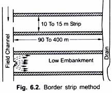
Border Method:
Borders are formed by dividing the field into a number of strips which are separated by ridges.
The strips are generally levelled along the width but may or may not have slope along the length.
An irrigation channel runs along the upper end of the borders.
The water is diverted from the channel into the strips. The water flows slowly towards the lower end, wetting the soil as it advances. Extra water is generally removed from the strip by means of a collecting drain. It is provided at the other end.
This method is suitable in the fields where the soil is sufficiently capable of absorbing the water.
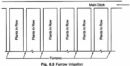
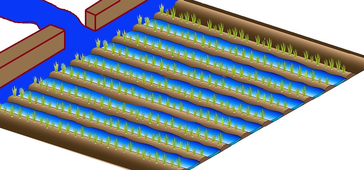
Furrow irrigation is adaptable to a great variation in slope, crops and topography.
When the crops are grown and planted in rows this method is the best suited. In this method, unlike flooding, only a part of the field is wetted. The area wetted varies from 1/2 to 1/5 of total area over which crops are grown.
Close growing crops, on slopes and soils that develop crust after being wet, may be irrigated with small furrows which are called corrugations or rills.
Furrow spacing should be such that the lateral water movement of the moisture wets the ridges by the time irrigation is complete. The lateral movement from the furrows depends on the soil type.
Furrow spacing is determined by agronomic requirements of row-to-row spacing and machinery to be used for planting and cultivation.
Furrow length: Longer furrows = more percolation and less run-off
Benefits of this method:
In this method plants in their early tender age are not damaged by the flow of water.
The land between the rows of plants is utilised to construct furrows, therefore useful irrigable land is not wasted.
As the area wetted is just 1/2 to 1/5 of the cropped area of the field, puddling and crusting of the soil is minimum.
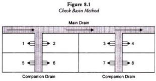
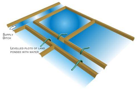
Check basin:
It consists of running water into relatively level plots surrounded by small ridges.
The length of the plot is generally less than 3 times the width.
The main and lateral channels irrigate The main channel is aligned along the upper end of the field and checks are made on the either side of the lateral channels.
The check basins are especially suitable for heavy soils with low infiltration rate or highly permeable sandy soils.
The key to attaining high irrigation efficiency in the design of the check basin is to spread water over the entire basin as rapidly as possible.
Therefore, the use of large inflow stream reduces water spread time over the basin.
Sprinkler and Micro-Sprinkler Application:
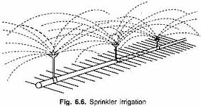
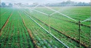
Sprinklers:
This system sprinkles water in a manner similar to rainfall so that run-off and deep percolation losses are avoided and the uniformity of application is quite high.
The system consists of sprinkler heads or nozzles, which are mounted on risers in lateral lines taken from the main line, which is further connected to a pumping unit.
The soil is too porous for good distribution by surface irrigation.
The fields have an uneven surface.
The soil is easily erodable.
The water supply is just sufficient for crop growth.
Merits:
Sprinklers can be used on all soil types of any topography.
It entails increased irrigation frequency which has a positive effect on crop yield.
In this method, a water saving of 30% to 50% is reported in comparison to the surface method of irrigation
Thus by introducing sprinklers, an additional area ~ up to 50% can be brought under irrigation besides increased crop yields
The overall efficiency of the system is above 80% and no land is wasted on making bunds and channels, and about 40-50% of saving in labour as compared to surface irrigation.
Only 2 to 5% water is lost through evaporation.
Demerits:
Expensive
Requires continuous maintenance and skill for installation and operation
The high energy requirement for operation as sprinklers operate at water pressure ranging from 1 to 10 kg/sq cm.
Wind interferes with the distribution pattern. It reduces the spreading rate and in turn the efficiency. Under high temperatures and strong winds heavy evaporation loss takes place thereby offsetting the saving in water.
Micro-sprinklers:
It sprinkles around the root zone with small sprinklers that work under low pressure.
In this method, water is applied only to the root zone area unlike to the entire field as in the case of sprinkler irrigation method.
This method is highly suitable for orchard crops and vegetable crops.
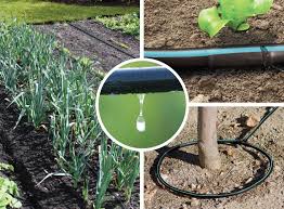
Drip Application
In this method, the application of water is precise but slow as discrete drops, continuous drops, tiny streams or miniature sprays through mechanical devices, called emitters or applicators located at selected points along water delivery lines.
This is useful in areas with water scarcity and salt problems.
Drip irrigation system consists of main pipe, sub-mains, lateral valves, drippers or emitters, a riser valve, vacuum breakers, pressure gauges, water metres, filters, fertiliser tanks etc.
These are designed to supply water at desired rates (1 to 10 litres/hour) directly to the soil.
Low pressures ranging from 0.35 to kg/sq cm are sufficient for drip system
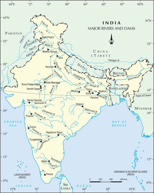
Dams were traditionally built to impound rivers and rainwater that could be used later to irrigate agricultural fields. Today, dams are built not just for irrigation but for:
electricity generation,
water supply for domestic and industrial uses,
flood control,
recreation,
inland navigation,
fish breeding etc.
Hence dams are now referred to as multipurpose projects where the many uses of the impounded water are integrated with one another. For example, in the Satluj-Beas river basin, the Bhakra Nangal project water is being used both for hydel power production and irrigation. Similarly, the Hirakud project in the Mahanadi basin integrates conservation of water with flood control.
Multipurpose projects, launched after independence with their integrated water resources management approach, were thought of as the vehicle that would lead the nation to development and progress. But in the recent years, multipurpose projects and large dams have come under great scrutiny for a variety of reasons:
Regulating and damming of rivers affects their natural flow causing poor sediment flow and excessive sedimentation at the bottom of the reservoir, resulting in rockier stream beds and poorer habitats for the rivers’ aquatic life.
Dams also fragment rivers making it difficult for the aquatic fauna to migrate, especially for spawning.
The reservoirs that are created on floodplains also submerge the existing vegetation and soil leading to its decomposition over a period of time.
In geologically unstable areas, development of large dams can destabilise the land. The 2013 Uttarakhand Floods triggered a debate on whether the hydropower projects operational in Uttarakhand were responsible for the floods that killed more than 1000 people.
Inter-state water disputes are also becoming common with regard to sharing the costs and benefits of the multipurpose projects.
Source
A List of Important River Water Projects in India:
The monsoonal rainfall in India is concentrated only in four months and more than 50% of the net sown area is rainfed only. Irrigation is thus essential to overcome spatial and temporal variation of rainfall.
Archaeological and historical records show that from ancient times we have been constructing sophisticated hydraulic structures like dams built of stone rubble, reservoirs or lakes, embankments and canals for irrigation. Not surprisingly, we have continued this tradition in modern India by building dams in most of our river basins. Before we look at these methods of irrigation in detail, let’s have a look at some of the hydraulic structures used in ancient India!
Some Hydraulic Structures used in Ancient India:
In the first century BC, Sringaverapura near Allahabad had sophisticated water harvesting system channelling the flood water of the river Ganga.
During the time of Chandragupta Maurya, dams, lakes and irrigation systems were extensively built.
Evidences of sophisticated irrigation works have also been found in Kalinga (Orissa), Nagarjunakonda (Andhra Pradesh), Bennur (Karnataka), Kolhapur (Maharashtra), etc.
In the eleventh century, Bhopal Lake, one of the largest artificial lakes of its time was built.
In the 14th century, the tank in Hauz Khas, Delhi was constructed by Iltutmish for supplying water to the Siri Fort Area.
Coming back to irrigation in the present day India, let’s look at some important facts and figures before we move forward:
Some important facts and figures:
The net irrigated area = 66.1 million hectares.
Total/Gross Irrigated Area = 92.6 million hectares.
Irrigation Intensity in India = (Gross Irrigated Area ÷Gross Sown Area) * 100
= (92.6 ÷ 194.4) *100
= 47.6%
More than 50% of the country’s cropped area depends exclusively on rainfall, most of which is concentrated in a few months of the year. Even where the annual overall precipitation is high, the available moisture is not adequate to support multiple cropping.
Ultimate Irrigation Potential:
As seen in the above figures, only about 66mha i.e. 47.6% of the net sown area is estimated to be irrigated. There is a need to bring more cropped area under assured irrigation so as to increase agricultural productivity and production.
The total ultimate irrigation potential of the country has been estimated as 140mha, with about 76 mha from surface water sources and about 64mha from groundwater sources.
Irrigation – Sources and Methods
The main sources of irrigation in India are:
Canals
Wells (and tubewells)
Tanks
The relative importance of these has been changing from time to time. Let’s look at these in detail:
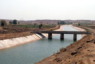
1. Canal Irrigation:
A canal is an artificial watercourse constructed for water supply and irrigation.
Inundation Canals – These are taken out from the rivers without any regulating system like weirs etc at their head. Such canals are useful only during the rainy season
Perennial Canals – These are those which are taken off from perennial rivers by constructing a barrage across the river. Most of the canals at present in India are perennial.
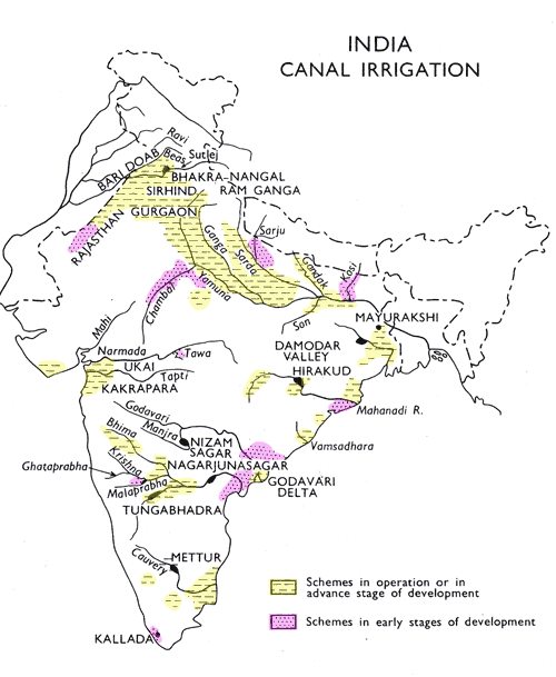
Canals can be an effective source of irrigation in areas of low relief, deep fertile soils, perennial source of water and an extensive command area. Therefore the main concentration of canal irrigation is in the northern plains.
The canals are practically absent from the peninsular plateau region because of rocky terrain. However, the coastal and the delta regions in South India have some canals for irrigation.
The percentage of canal irrigation area to total irrigated area in the country has fallen from about 40% in 1950-51 to less than 25% at present.
The states UP, Punjab, Haryana, Rajasthan and Bihar account for about 60% of the canal irrigated area in the country.
Merits of canal irrigation:
Perennial Source
Provides safety from droughts
Brings fertile sediments to the fields
Economical to serve a large area
Demerits:
Canal water soaks into the ground and leads to water logging, increases salinization, and leads to marshy conditions leading to malaria and flooding
Wastage of water.
2. Wells (and Tube Wells)
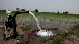
A well is a hole dug in the ground to obtain the subsoil water. An ordinary well is about 3-5 metres deep but deeper wells up to 15 metres are also dug.
This method of irrigation has been used in India from time immemorial. Various methods are used to lift the ground water from the well. Some of the widely used methods are the persian wheel, reht, charas or mot, and dhinghly (lever) etc.
A tube well is a deeper well (generally over 15 metres deep) from which water is lifted with the help of a pumping set operated by an electric motor or a diesel engine.
Well irrigation is gradually giving way to energized tube wells. But there are many wells still in use where electricity is not available or the farmers are too poor t0 afford diesel oil.
This method of irrigation is popular in those areas where sufficient sweet ground water is available.
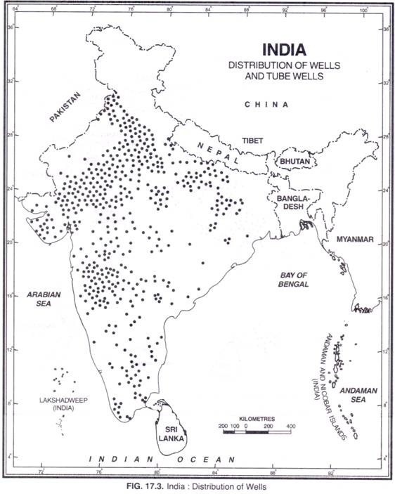
It is particularly suitable in areas with permeable rock structure which allows accumulation of ground water through percolation. Therefore wells are seen more in areas with alluvial soil, regur soil, etc. and less seen in rocky terrain or mountainous regions.
These areas include a large part of the great northern plains, the deltaic regions of the Mahanadi, the Godavari, the Krishna and the Cauvery, parts of the Narmada and the Tapi valleys and the weathered layers of the Deccan trap and crystalline rocks and the sedimentary zones of the peninsula
However, the greater part of peninsular India is not suitable for well irrigation due to rocky structure, uneven surface and lack of underground water.
Large dry tracts of Rajasthan, the adjoining parts of Punjab, Haryana and Gujarat and some parts of Up have brackish ground water which is not fit for irrigation and human consumption and hence unsuitable for well irrigation
At present irrigation from wells and tubewells accounts for more than 60% of the net irrigated area in the country.
UP has the largest area under well irrigation which accounts for 28% of the well irrigated area of the country. U.P., Rajasthan, Punjab, Madhya Pradesh, Gujarat, Bihar and Andhra Pradesh account for about three-fourths of the total well-irrigated area
Well is an independent source of irrigation and can be used as and when the necessity arises. Canal irrigation, on the other hand, is controlled by other agencies and cannot be used at will.
Some ground water salts are useful for crops
Does not lead to salinization and flooding problems
There is a limit to the extent of canal irrigation beyond the tail end of the canal while a well can be dug at any convenient place.
Demerits
Only limited area can be irrigated. Normally, a well can irrigate 1 to 8 hectares of land.
Not suitable for dry regions
Overuse may lead to lowering of water table
3. Tank irrigation
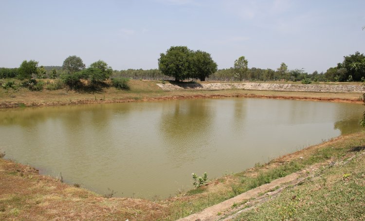
A tank is a reservoir for irrigation, a small lake or pool made by damming the valley of a stream to retain the monsoon rain for later use.
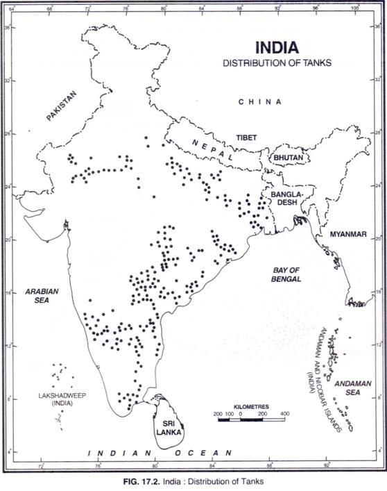
It is practised mainly in the peninsular region due to the following reasons:
The undulating relief and hard rocks make it difficult to dig canals and wells
There is little percolation of water due to hard rock structure and ground water is not available in large quantities.
Most of the rivers are seasonal; there are many streams which become torrential during the rainy season – so the only way to use this water is to impound it by constructing bunds and building tanks. Also, it is easy to collect rainwater in natural or artificial pits because of impermeable rocks.
Scattered nature of agricultural fields
Merits
Most of the tanks are natural and do not involve cost for their construction
Independent source for an individual farmer or a small group of farmers
longer life span
can be used for fishing also
Demerits
Depends on rain and these tanks may dry up during the dry season
Silting of their beds
Require large areas
Evaporation losses
Sometimes there might be a need to lift the water to take it to the field
Knowing a soil’s water, mineral, and organic components and their proportions can help us determine its productivity and what the best use for that soil may be. Several soil properties that can be readily tested or examined are used to describe and differentiate soil types. The most important properties are discussed below:
1. Colour: A soil’s colour is generally related to its physical and chemical characteristics. E.g.
Soils rich in humus tend to be dark because decomposed organic matter is black or brown. Soils with high humus content are usually very fertile, so dark brown or black soils are often referred to as ‘rich’. [Note – Some dark soils may be dark because of other soil forming factors and may have little or no humus]
Red or yellow soils typically indicate the presence of iron.
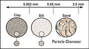
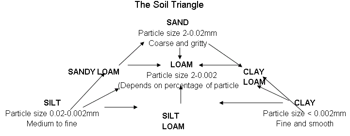
2. Texture: The soil texture refers to the coarseness/fineness of the mineral matter in the soil. It is determined by the proportion of the sand, silt and clay particles:
Clay: Particle Size – diameters less than 0.002 millimetre
Silt: Particle Size – diameters between 0.002 millimetres to 0.05 millimetres.
Sand: Particle Size – diameters between 0.05 and 2 millimetres.
[Rocks larger than 2 millimetres are regarded as pebbles, gravel, or rock fragments and technically are not soil particles.]
Note:
Clay being the finest of all plays the most important role in soil chemistry (offers more surface area).
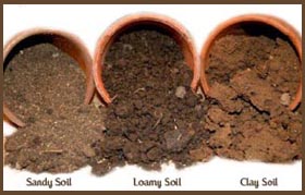
Loamy Soil: Loamy soil is the one in which none of the three (sand/silt/clay) dominates the other two. In particular, loamy soil has about 40% sand, 40%silt, and 20% clay.
Generally speaking, Good Soils = Clay + Humus. The clay-humus complex is essential for a fertile soil as it provides it with a high water and nutrient holding capacity. Humus acts as a cement binding the soil particles together and thus reducing the risk of erosion.
3. Structure :
While the soil texture describes the size of soil particles, soil structure refers to the arrangement of the soil particles. The way in which sand, silt, clay and humus bond together is called soil structure. Structure can partially modify the effects of soil texture.
Some structural characteristics of soil:
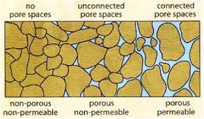
Permeability – The ease with which liquids/gases can pass through rocks or a layer of soil is called permeability. It depends on the size, shape and packing of particles. It is usually greatest in sandy soils and poor in clayey soils.
Porosity – The volume of water which can be held within a soil is called its porosity. It is expressed as a ratio of volume of voids (pores) to the total volume of the material.
Note: Most porous rocks are permeable with the exception of clay in which pore spaces are so small that they are often sealed with groundwater held by surface tension. Another exception – granite is non-porous but permeable. It is a crystalline rock and hence non-porous. Its individual crystals absorb little or no water but the rock may have numerous joints/ cracks through which the water can pass rendering it permeable.
A soil with high organic content also tends to have high porosity.
4. Soil Chemistry – Acidity or Alkalinity:
An important aspect of soil chemistry is acidity, alkalinity (baseness), or neutrality.
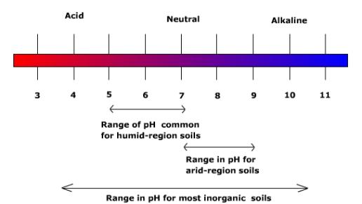
Low pH values indicate an acidic soil, and a high pH indicates alkaline conditions. Most complex plants grow only in the soils with levels between pH 4 and pH 10 but optimum pH varies with the plant species.
In arid and semi-arid regions, soils tend to be alkaline and soils in humid regions tend to be acidic.
To correct soil alkalinity and to make the soil more productive, the soil can be flushed with irrigation water.
Strongly acidic soils are also detrimental to plant growth, but soil acidity can generally be corrected by adding lime to the soil.
Now that we are done with the basics, let’s move on to the soils of India!
Soils of India
India has varied relief features, landforms, climatic realms and vegetation types. These have contributed to the development of various types of soils in India.
Various classifications adopted to study the Indian Soils:
1. In ancient times, soils used to be classified into two main groups:
Urvara (i.e. fertile), and
Usara (i.e. sterile)
2. In the 16th century A.D., soils were classified on the basis of their inherent characteristics and external features such as texture, colour, the slope of land and moisture content in the soil.
Based on texture, main soil types were identified as sandy, clayey, silty and loam, etc.
On the basis of colour, they were red, yellow, black, etc.
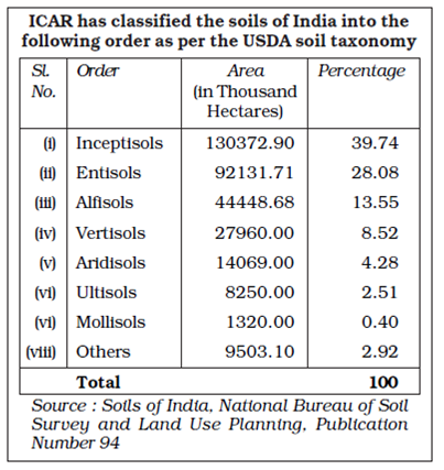
3. The National Bureau of Soil Survey and the Land Use Planning an Institute under the control of the Indian Council of Agricultural Research (ICAR) did a lot of studies on Indian soils. In their effort to study soil and to make it comparable at the international level, the ICAR has classified the Indian soils on the basis of their nature and character as per the United States Department of Agriculture (USDA) Soil Taxonomy.
Chief characteristics of these are:
Entisols – Immature soils that lack the vertical development of horizons. These soils are often associated with recently deposited sediments from wind, water, or ice erosion. Given more time, these soils will develop into another soil type.
Inceptisols – young soils that are more developed than entisols.
Vertisols – heavy clay soils that show significant expansion and contraction due to the presence or absence of moisture. These are common in areas that have shale parent material and heavy precipitation.
Aridisols – soils that develop in very dry environments.
Ultisols – associated with humid temperate to tropical climates. Warm temperatures and the abundant variability of moisture enhance the weathering process and increase the rate of leaching in these soils.
Mollisols – soils common to grassland environments
4. On the basis of genesis, colour, composition and location, the soils of India have been classified into:
(i) Alluvial soils
(ii) Black soils
(iii) Red and Yellow soils
(iv) Laterite soils
(v) Arid soils
(vi) Saline soils
(vii) Peaty soils
(viii) Forest soils.
5. Another way of classifying rocks is on the basis of dominant soil forming factors:
Zonal Soil – These soils occur in broad geographical areas or zones.
They are influenced more by the climate and vegetation of the area rather than the rock-type.
They are mature, as a result of stable conditions over a long period of time.
For example – red soils, black soils, laterite soils, desert soils etc.
Azonal Soil – It is that soil which has been developed by the process of deposition by the agents of erosion.
It means that it has been made by the fine rocky particles transported from the far-off regions.
These are immature soils and lack well-developed soil profiles. This may be due to the non-availability of sufficient time for them to develop fully or due to the location on very steep slopes which prohibits profile development.
For Example – alluvial and loess soils.
Intrazonal Soil – These soils occur within other zonal soils.
It is a well-developed soil reflecting the influence of some local factor of relief, parent material, or age rather than of climate and vegetation.
For example, calcerous soil (soils which develop from limestone), peat soil.
The major factors responsible for the formation of soil:
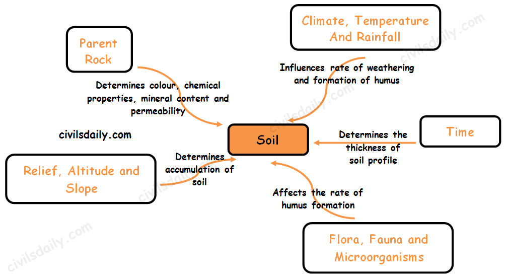
The major factors affecting the formation of soil are relief, parent material, climate, vegetation and other life-forms and time. Besides these, human activities also influence it to a large extent.
1. Parent Material
The parent material of soil may be deposited by streams or derived from in-situ weathering. Soil inherits many properties from the parent material from which it forms, for example, the mineral composition, the colour, the particle size and the chemical elements.
For Example,
The peninsular soils reflect the parent rock very much.
The ancient crystalline and metamorphic rocks which are basically granite, gneiss and schist form red soils on weathering because they contain iron oxide.
Soils derived from lava rocks are black coloured.
Sandy soils are derived from sandstone.
At the same time, the soils of the northern plains are transported and deposited from Himalayan and peninsular blocks, so they have little relation to rock material in-situ.
2. Climate
The role of climate is to vary the inputs of heat and moisture. It affects the rate of weathering of the parent rock. Hot and humid environments, in general, witness the most rapid weathering of parent materials.
Role of precipitation: In areas that experience a lot of rainfall, water percolating down through soil tends to leach nutrients and organic matter out of the upper layers, unless modified by other soil components like plant roots.
E.g. the soils underlying tropical rain forests tend to be nutrient-poor because of intensive leaching due to heavy rains; most of the nutrients are stored in the lush vegetation itself.
Conversely, in arid regions with little annual precipitation, high rates of evaporation encourage the accumulation of salts in the soil.
Role of temperature: Solar energy, usually expressed as temperature, controls the form of water falling onto the soil surface as well as in the soil. Also, it increases the rate of reactions, such as chemical reactions, evapotranspiration and biological processes. Wide fluctuations in temperature, especially in the presence of water cause shrinking and swelling, frost action and general weathering in soils.
E.g. Laterite soils are found in alternate wet and dry climate.
In Rajasthan, both granite and sandstone give birth to sandy soil irrespective of parent rock because of high temperature and wind erosion.
3. Biota (Flora, Fauna and Microorganisms):
Biota, in conjunction with climate, modifies parent material to produce soil.
The kind and amount of plants and animals that exist bring organic matter into the soil system as well as nutrient elements. This has a great effect on the kind of soil that will form.
E.g. Soils formed under trees are greatly different from soils formed under grass even though other soil-forming factors are similar.
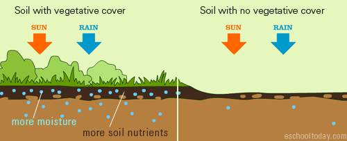
The roots of plants also hold the soils and protect them from wind and water erosion. They shelter the soils from the sun and other environmental conditions, helping the soils to retain the needed moisture for chemical and biological reactions.
Topography is often considered a passive factor modifying the effects of climate.
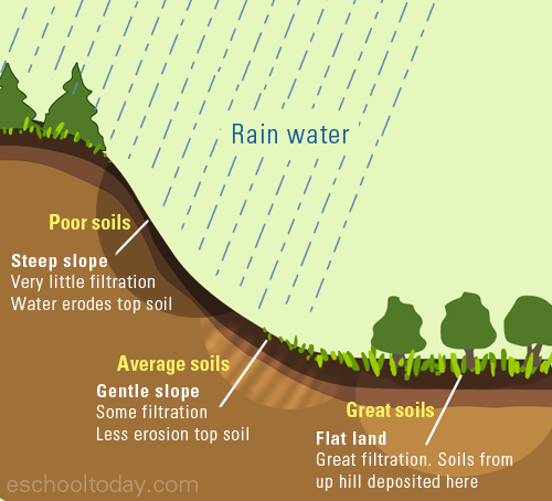
Topography redistributes the water reaching the soil surface. Runoff from uplands creates wetter conditions on the lowlands, in some cases saline sloughs or organic soils. Thus, as a redistributor of the climate features, topography affects soil processes, soil distribution and the type of vegetation at the site.
Soils can take many years to form. Younger soils have some characteristics from their parent material, but as they age, the addition of organic matter, exposure to moisture and other environmental factors may change its features. With time, they settle and are buried deeper below the surface, taking time to transform. Eventually, they may change from one soil type to another.
Look at the following diagram for a quick revision of the above-discussed facts:
Note:
The above factors are not mutually exclusive but interdependent. For example, the kind of vegetation found at any one location on the earth’s surface is dependent on climate, parent material, topography, time and, in fact, soil. It is obvious that numerous combinations of the factors are possible. This leads to many different kinds of soils, each representing a certain combination of the factors of soil formation.
Soil Profile
As we discussed earlier, soil development begins when plants and animals colonize rocks or deposits of rock fragments. Once organic processes start among mineral particles or rock fragments, chemical and physical differences begin to develop from the surface down through the parent material.
Initially, vertical differences result from surface accumulations of organic litter and the removal of fine particles and dissolved minerals by percolating water that deposits these materials at a lower level.
Over time, as climate, vegetation, animal life, and the land surface affect soil development, this vertical differentiation becomes increasingly apparent.
If you could dig a massive trench, about 50-100ft vertically downwards into the ground, you will notice that you would have cut through various layers of soil types. A look at the layers from a distance gives one a cross-section view of the ground (beneath the surface) and the kind of soils and rocks it is made up of. This cross section view of soil from the surface down to the parent material is called a Soil Profile.
The Soil Profile is a product of the balance between the soil system inputs (i.e. additions) and outputs (i.e. losses) and the redistribution of (i.e. translocations), and chemical changes (transformations) in the various soil constituents.
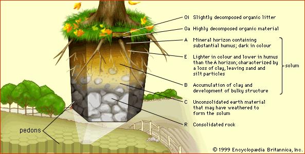
The soil profile is made up of layers, running parallel to the surface, called Soil Horizons. These layers are distinguished by their physical and chemical properties.
Most soils have three major horizons. These are A Horizon, B Horizon and C Horizon. Aside these three, there are also the O, E and R horizons. How are they different? Let’s see!
O-Horizon: The O-horizon is very common to surfaces with lots of vegetative cover. It is the layer made up of organic materials such as dead leaves and surface organisms, twigs and fallen trees. In fact, the ‘O’ designation refers to this horizon’s high content of organic debris and humus. It is often black or dark brown in colour, because of its organic content. It is the layer in which the roots of small grass are found. The A-Horizon: The A horizon, immediately below the O horizon, is usually known as the topsoil. It is the top layer soil for many grasslands and agricultural lands. In general, A horizons are dark because they contain decomposed organic matter. The E-Horizon: The E horizon is usually lighter in colour, often below the O and A horizons. It is often rich in nutrients that are leached from the top A and O horizons. It has a lower clay content and is common in forested lands or areas with high-quality O and A horizons. The B-Horizon: Below the E-horizon is the B-horizon, a zone of accumulation, where much of the nutrients removed from the A and E horizons are deposited. It is the layer in which the roots of big trees end. There is a close relationship between the A and B horizons. Translocations, as well as, many biological and chemical reactions take place between them. The B horizon, however, tends to be more stable than the A for short term differences. The C-Horizon: The C horizon is the weathered parent material from which the soil has developed. This layer is the first stage in the soil formation process and eventually forms the above two layers. The C horizon is also known as saprolite. The R-Horizon: It is the unweathered parent material.
Before we discuss the various soil types and their distribution in India, it is imperative that we first go through the basics. Let’s begin with what soil is and how it is formed:
What is soil?
Soil is the loose material of the earth’s surface in which the terrestrial plants grow. It is usually formed from weathered rock or regolith changed by chemical, physical and biological process.
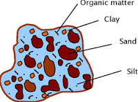
Thus the soil may be considered as an entity, quite apart from the rocks below it. It consists partly of mineral particles and partly, to a varying extent, of organic matter. Let’s look at the composition in detail:
Composition of soils:
Soils have four main constituents:
Mineral matter – It includes all minerals inherited from the parent material as well as those formed by recombination from substances in the soil solution.
Organic matter – It is derived mostly from decaying plant material broken down and decomposed by the actions of animals and microorganisms living in the soil. It is this organic portion that differentiates soil from geological material occurring below the earth’s surface which otherwise may have many of the properties of a soil. (Note: The end product of breakdown of dead organic material is called humus.)
Air
Water
Normally, both air and water fill the voids in soil. Air and water in the soil have a reciprocal relationship since both compete for the same pore spaces.
For example, after a rain or if the soil is poorly drained, the pores are filled with water and air is excluded. Conversely, as water moves out of a moist soil, the pore space is filled with air. Thus the relationship between air and water in soils is continually changing.
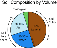
The ratio of the components by volume is generically indicated as:
Note: The exact ratio depends on various factors like geographical location and the historical treatment of soil – by humans, by climate, by time.
Why is soil so important?
Soils are essential for life, in the sense that they provide the medium for plant growth, habitat for many insects and other organisms, act as a filtration system for surface water, carbon store and maintenance of atmospheric gases. They also support buildings and highways and contribute to the economies of our cities.
E.g. the rich, deep fertile soils of the Ganga plain especially its delta and the coastal plains of Kerala support a high density of population through agricultural prosperity. On the other hand, the shallow and coarse-grained soils of Telangana and Rajasthan do not provide a base for prosperous agriculture and thus support only a small population.
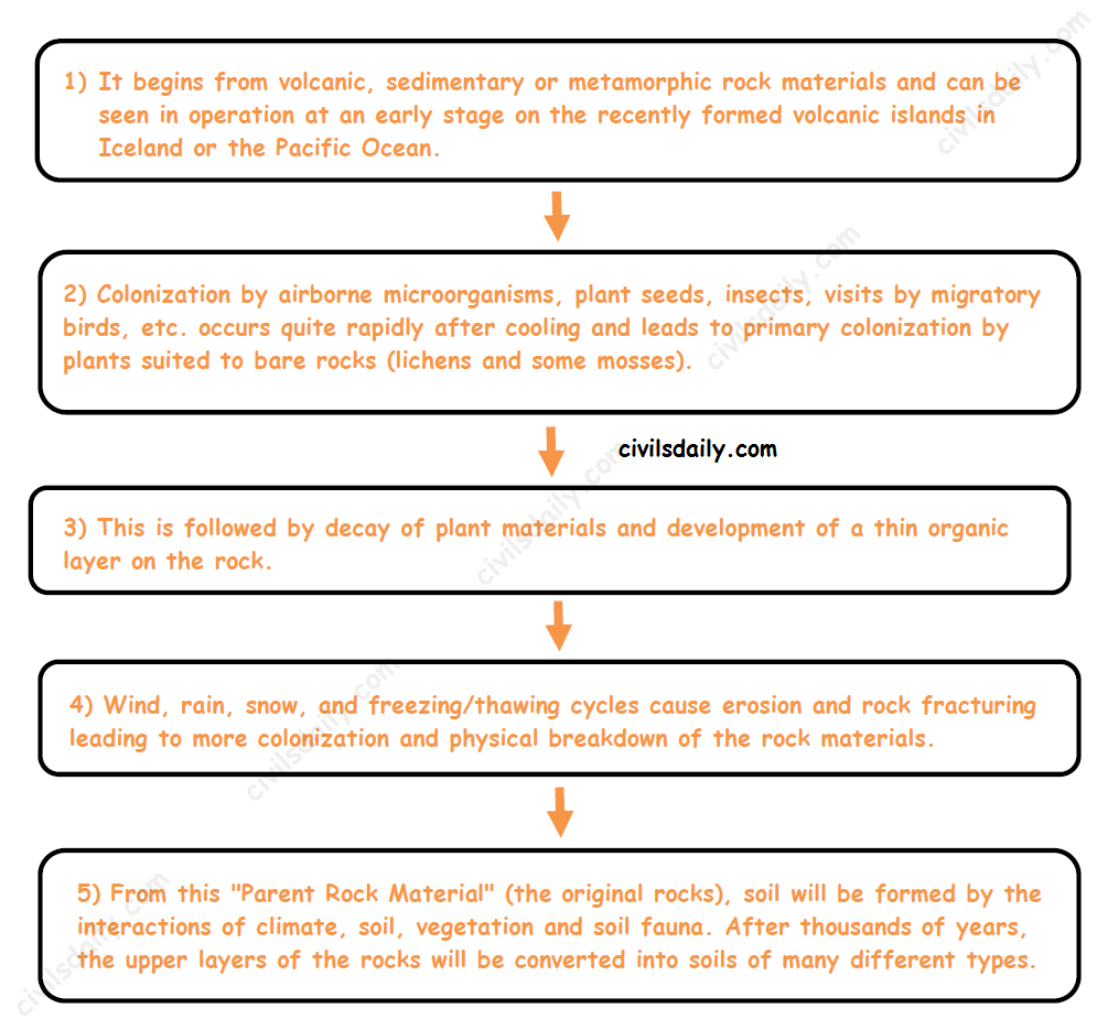
At the same time, the soil must not be regarded as a passive and inert body on the earth’s surface. It is a continually changing system within the total environment. The nature of a soil reflects the ancient environments under which it formed as well as current environmental conditions. The soil forming process, also known as pedogenesis, is described below:
How is soil formed?
Soil formation is a process taking many thousands of years.
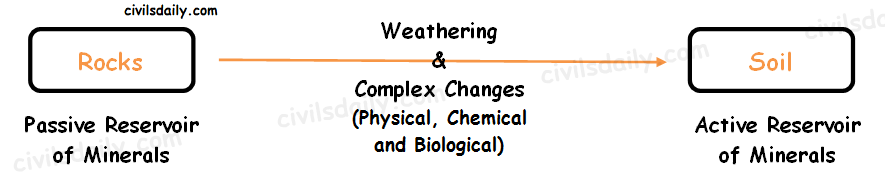
Formation of soil from rocks.
The Pedogenic Processes:
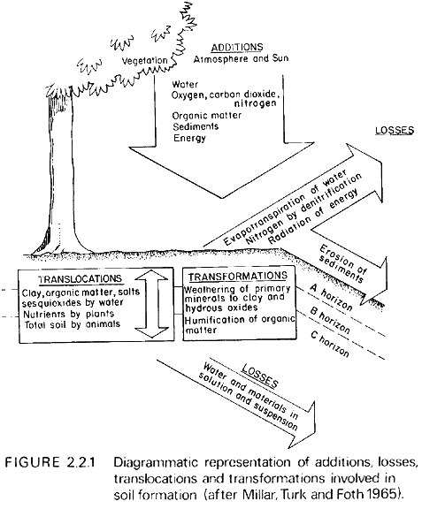
The above-explained conversion from rocks to soils happens via four basic processes:
Additions
Losses
Translocations
Transformations
Let’s look at these soil forming processes in detail:
Additions: Most additions occur at the surface. The most obvious ones include solar energy, water controlled by climate, and organic material derived principally from the vegetation.
Losses: Losses occur both from the surface and from the deep subsoil. For instance, water is lost by evapotranspiration and carbon dioxide by diffusion at the surface and, on a more catastrophic level, large masses of soil can be stripped by erosion. Materials suspended or dissolved in water are the main forms of losses from the subsoil e.g. leaching.
Translocation: It refers to the physical movement of material within the soil. The material can be in the solid, liquid or gaseous form, the movement can be in any direction from and to any horizon. For instance clay, organic matter and iron and aluminium hydrous oxides are commonly moved from the surface horizon to a subsurface horizon. Conversely, in very dry climates salts are moved upwards in solution by capillarity, and in very cold climates solid mineral fragments are moved upwards by frost action.
Transformation: Additions, losses and translocations all involve movement as shown in the above figure. Transformations, on the other hand, involve the change of some soil constituent without any physical displacement. Chemical and physical weathering and the decomposition of organic matter are included here.
All these processes occur to a greater or lesser extent in all soils. The properties that characterise one soil are the result of a particular balance among all the processes. Other soils will be different because they have been formed by groups of processes having different balances.
The two driving forces for these processes are:
climate (temperature and precipitation), and
organisms, (plants and animals).
Passive factors:
Parent material is usually a rather passive factor in affecting soil processes because parent materials are inherited from the geologic world.
Topography (or relief) is also rather passive in affecting soil processes, mainly modifying the climatic influences of temperature and precipitation.
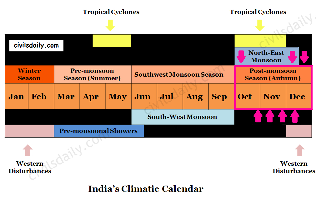
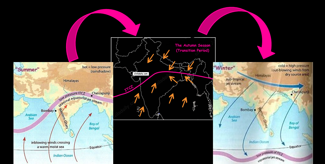
The months of October-November form a period of transition from the hot rainy season to the dry winter conditions.
Surface Air Circulation during the Autumn Period. Source
The withdrawal of the south-west monsoon and the onset of north-east monsoon are both gradual phenomenon. They take place almost at the same time and tend to merge. This explains the popularity of the phrase “Retreating Monsoon”.
A Season of Retreating Monsoon
The retreat takes place due to the weakening of the low-pressure area over the north-western parts of India (and thus a gradual transition of ITCZ towards the south). This happens due to:
The apparent shift of sun towards the equator
Reduction in temperature due to widespread rains.
Consequently, the air pressure starts decreasing. Such changes in the atmospheric pressure cause the south-west monsoons to withdraw.
The Retreat of Monsoons is a process much slower than its arrival. It does not imply a right about turn but a gradual change of comparative pressure positions, thus gradually weakening and reducing the area of coverage and influence.
The retreat:
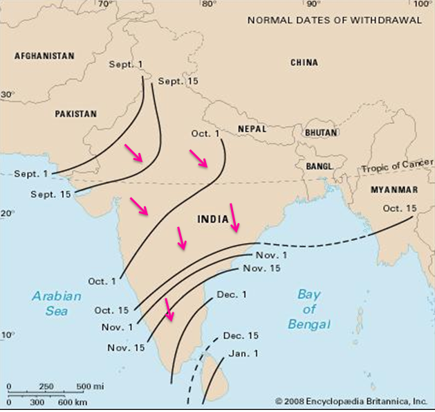
The south-west monsoons start retreating in the first week of September from Pakistan’s border in North-West India. Thus these winds withdraw earlier from the regions they reached the last.
The monsoon retreats from the western Rajasthan by the first week of September. It withdraws from Rajasthan, Gujarat, Western Ganga plain and the Central Highlands by the end of the month. By the beginning of October, the low pressure covers northern parts of the Bay of Bengal and by early November, it moves over Karnataka and Tamil Nadu. By the middle of December, the centre of low pressure is completely removed from the Peninsula.
This season is marked by clear skies and a rise in temperature. The land is still moist. Owing to the conditions of high temperatures (around 25°C) and humidity, the weather becomes rather oppressive and unbearable. This is commonly known as the ‘October heat’ or ‘Kwar ki Umas’.
In the second half of October, the mercury begins to fall rapidly, particularly in northern India. This continuous decrease in temperature after mid-October helps winter to set in by November or Early December.
Surface Winds and Precipitation:
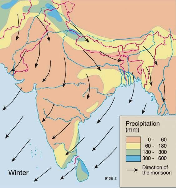
By and large, the topography of the region influences the wind direction:
The winds are westerly or northwesterly down the Ganga Valley.
They become northerly in the Ganga-Brahmaputra delta.
Free from the influence of topography, they are clearly north-easterly over the Bay of Bengal (thus the name North-East monsoon).
Precipitation:
Winter monsoons do not cause rainfall as they move from land to the sea. It is because:
They have little humidity; and
Due to anti-cyclonic circulation on land, the possibility of rainfall from them reduces.
However, there are some exceptions:
These months are the rainiest months of the year in coastal areas of Tamil Nadu. This is because the large indentation made by the Bay of Bengal into India’s eastern coast means that the flows are humidified before reaching Cape Comorin and rest of Tamil Nadu. Parts of West Bengal, Orissa, Andhra Pradesh, Karnataka and North-East India also receive minor precipitation from the northeast monsoons.
Central parts of India and northern parts of southern Peninsula also get winter rainfall occasionally.
Arunachal Pradesh and Assam in the northeastern parts of India also have rains between 25 mm and 50 mm during these winter months.
The low-pressure area lying over north-west India is transferred to the middle of Bay of Bengal by the end of October. As a result of these unstable conditions, severe cyclonic storms originate in this region.
These cyclonic storms strike along the eastern coast of India causing widespread rain in the coastal regions.
These tropical cyclones are very destructive. The thickly populated deltas of the Godavari, Krishna and Kaveri are their preferred targets. Every year cyclones bring disaster here. A few cyclonic storms also strike the coast of West Bengal, Bangladesh and Myanmar.
A bulk of the rainfall of the Coromondal coast is derived from these depressions and cyclones. Such cyclonic storms are less frequent in the Arabian Sea.
Now that we have studied all the seasons in detail, let’s have a look at the annual distribution and variability of rainfall in India:
Rainfall Distribution:
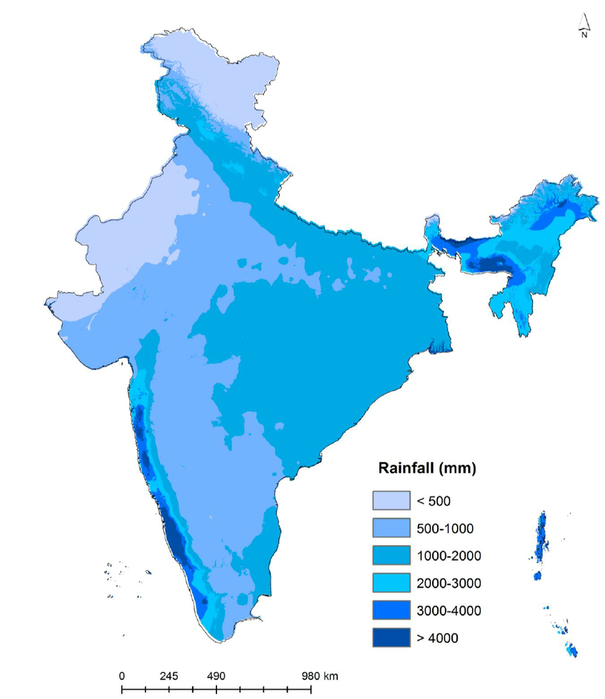
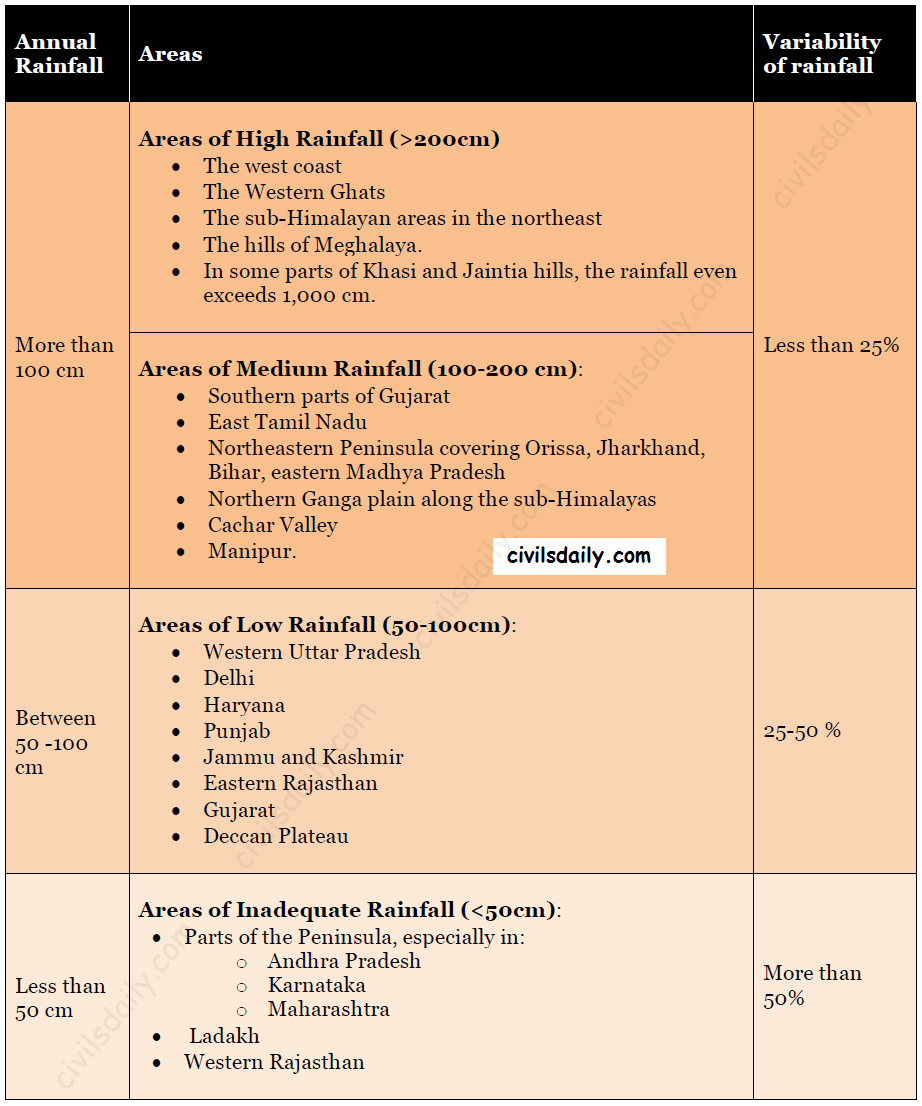
The distribution of rainfall in India is highly uneven. Its distribution is largely controlled by the nearness of the sea and orographic features. The average annual rainfall in India is shown in the following map. Notice that the regional variations in the distribution of rainfall over India are quite pronounced.
The rainfall in India is highly variable. The actual rainfall of a place in a year deviates from the average rainfall by 10-60%.The variability of rainfall is computed with the help of the following formula:
The variability of rainfall is computed with the help of the following formula:
C.V. = (Standard Deviation÷ Mean) × 100
where C.V. is the coefficient of variation.
RainfallVariability in India
Notice that the regions of inadequate rainfall are also the regions with the highest variability of rainfall. The variability of rainfall has a significant role in the agricultural operations and other economic activities of a country. The areas showing high variability of rainfall have a chronic deficiency of water.
Climatic Regions of India
As discussed in the beginning, India has a monsoon type of climate with many regional variations. These variations represent the subtypes of the monsoon climate. It is on this basis that the climatic regions can be identified.
A climatic region has a homogeneous climatic condition which is the result of a combination of factors. Temperature and rainfall are two important elements which are considered to be decisive in all the schemes of climatic classification.
The classification of climate, however, is a complex exercise. There are different schemes of classification of climate. Two important ones are discussed here:
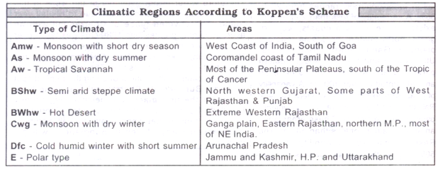
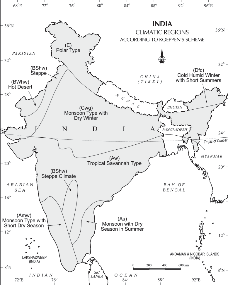
A) Koeppen’s scheme of Climatic classification
It is based on monthly values of temperature and precipitation.
He identified five major climatic types and used letter symbols A, B, C, D and E to denote them:
Tropical climates (A): [where mean monthly temperature throughout the year >18°C]
Dry climates (B): where precipitation is very low in comparison to temperature.
If dryness is less, it is semiarid (S);
If it is more, the climate is arid(W).
Warm temperate climates (C): where mean temperature of the coldest month is between 18°C and minus 3°C.
Cool temperate climates (D): where mean temperature of the warmest month is over 10°C, and mean temperature of the coldest month is under minus 3°C.
Ice climates (E), where mean temperature of the warmest month is under 10°C.
These five types can be further subdivided into sub-types on the basis of seasonal variations in the distribution pattern of rainfall and temperature. Koppen used small letters such as m, w or h to define these sub-types:
f (sufficient precipitation)
m (rain forest despite a dry monsoon season),
w (dry season in winter)
h (dry and hot)
c (less than four months with mean temperature over 10°C)
g (Gangetic plain)
Accordingly, India can be divided into the following eight climatic regions:
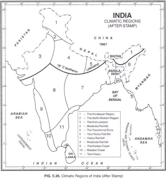
Kendrew and Stamp on the basis of the 18°C isotherm for the month of January (which almost follows the Tropic of Cancer) divided India into two major climatic regions:
Subtropical India (Continental)
Tropical
These two major climatic regions have been further divided into eleven regions as follows: