💥Join UPSC 2027,2028 Mentorship (August Batch) + XFactor Notes & Microthemes PDF

Subject: Conservation & Mitigation

1. Conservation Progs.
2. Worldwide initiatives
3. Mitigation Strategies
4. Conventions and Protocols

  • Agreement  on Cities combating plastic entering the marine environment

    Recently, India and Germany signed Cities combating plastic entering the marine environment’.

    The agreement was signed by the Ministry of Housing and Urban Affairs and the respective ministry of Germany.

    Key Points:

    • The project envisaged under the contours of the Joint Declaration of Intent regarding cooperation in the field of ‘Prevention of Marine Litter’ signed between Republic of India and Federal Republic of Germany in 2019.
    • It aims to prevent plastic entering the marine environment.
    • Focus will be on three cities namely Kanpur, Kochi and Port Blair.
    • Total time for the project is  3.5 years.

    About Marine Litter:

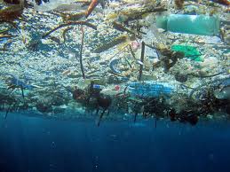
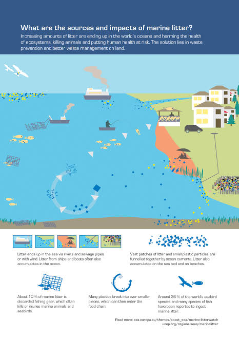
    According to UN Environment, marine litter is any persistent, manufactured or processed solid material discarded, disposed of or abandoned in the marine and coastal environment.

    Sources:

    • Items that have been made or used by people and deliberately discarded into the sea or rivers or on beaches.
    • indirectly brought to the sea by rivers, sewage, storm water or winds.
    • accidentally lost, including material lost at sea in bad weather (fishing gear, cargo)
    • deliberately left by people on beaches and shores.
    Impacts:

    • Marine litter threatens ecosystems and adversely affects fishery and tourism industries around the globe.
    • Affects  public health with increased concerns about micro-plastic and risk of particles entering the food chain.

    Suggestions

    • Port reception facilities
    • Creating a garbage management system
    • Sewage treatment plants designed to capture plastic litter.
    • Strict enforcement of norms preventing human led plastic waste discharge into aquatic and marine environments.
  • Take remedial action against WTE plants: NGT

    National Green Tribunal has directed Central Pollution Control Board (CPCB) and Delhi Pollution Control Committee (DPCC) to take remedial action against the three waste-to-energy plants in Ghazipur, Okhla and Narela-Bawana.

    Waste to Energy:

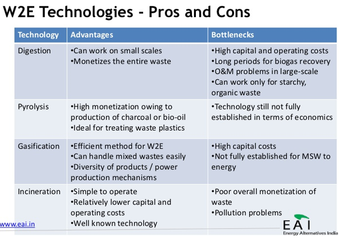
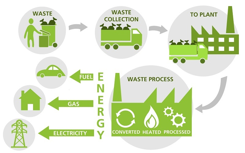
    • Waste to Energy or Waste to Power is the process of generating energy in the form of electricity and heat from the primary treatment of waste.

    Methods for waste to Power generation:

    1. Thermal technologies:

    • Incineration:
      • It is the most common and popular method for waste to energy generation.
      • The organics from the waste collected are burnt at high temperatures.
    • Gasification: Produces combustible gas, hydrogen, synthetic fuels
    • Thermal depolymerization: Produces synthetic crude oil, which can be further refined
    • Pyrolysis: Produces combustible tar/bio-oil and chars
    • Plasma arc gasification or plasma gasification process (PGP): Produces rich syngas including hydrogen and carbon monoxide usable for fuel cells or generating electricity to drive the plasma arch.

    2. Non-thermal technologies:

    • Anaerobic digestion: Biogas rich in methane
    • Fermentation production: Examples are ethanol, lactic acid, hydrogen
    • Mechanical biological treatment: Combines a sorting facility with a form of biological treatment such as composting.

    Advantages of WTE plants:

    • Decreases quantity of waste
    • Efficient waste management
    • Production of heat and power
    • Reduction of pollution
    • Incinerators have filters for trapping pollutants
    • Saves on transportation of waste
    • Provides better control over odour and noise
    • Prevents the production of methane gas

    Challenges for India:

    • Lack of general awareness on waste management
    • Unsegregated waste
    • High moisture content
    • Unorganized sector
    • High wear and tear of equipment due to foreign materials
    • Only electricity demand
    • Cycle Efficiency is low
    • Lack of enforcement of rules / regulations
    • Lack of Transparency in plant management
    • Lack of adequate waste disposal cost
    • Lack of customization of plant and machinery to suit Indian condition
  • Bustard Poaching in Pakistan

    The recent shooting of two Great Indian Bustards (GIBs) in Pakistan’s Cholistan desert has left wildlife activists in Rajasthan shocked and outraged.

    Great Indian Bustards

    • The GIB is one of the heaviest flying birds and can weigh up to 15 kg which grows up to one metre in height.
    • In July 2011, the bird was categorised as “critically endangered” by the International Union for Conservation of Nature (IUCN).
    • It is considered the flagship grassland species, representing the health of the grassland ecology.
    • For a long, conservationists have been demanding to secure this population, warning that the bird might get extinct in the coming decades.
    • It would become the first mega species to disappear from India after Cheetah in recent times.
    • Till the 1980s, about 1,500-2,000 Great Indian Bustards were spread throughout the western half of India, spanning eleven states.
    • However, with rampant hunting and declining grasslands, their population dwindled.

    Why in news?

    • The GIB, which is the state bird of Rajasthan, is considered India’s most critically endangered bird.
    • It is one of the most critically threatened species in India, with less than 150 birds left in the wild.

    Try this PYQ:

    Q.Which one of the following groups of animals belongs to the category of endangered species?

    (a) Great Indian Bustard, Musk Deer, Red Panda, Asiatic Wild Ass

    (b) Kashmir Stag, Cheetah, Blue Bull, Great Indian Bustard.

    (c) Snow Leopard, Swamp Deer, Rhesus Monkey, Saras (Crane)

    (d) Lion Tailed Macaque, Blue Bull, Hanuman Langur, Cheetah

  • Indian Rhino Vision 2020

    The ambitious Indian Rhino Vision 2020 (IRV 2020) came to a close with the release of two rhinos — an adult male and a female — in Assam’s Manas National Park transported from Pobitora Wildlife Sanctuary about 185 km east.

    Try this PYQ:

    Q.Recently there was a proposal to translocate some of the lions from their natural habitat in Gujarat to which one of the following sites?

    (a) Corbett National Park

    (b) Kuno Palpur Wildlife Sanctuary

    (c) Mudumalai Wildlife Sanctuary

    (d) Sariska National Park

    What is IRV 2020?

    • In 2005, conservationists, alongside the Bodoland Territorial Council and the Government of Assam, came together to develop a long-term strategy to manage the species.
    • Their vision was ambitious; to build a 3,000-strong wild population of Greater one-horned rhinos by 2020, spread across seven sites in the state of Assam.
    • Thus the “Indian Rhino Vision 2020” (IRV2020) was born.

    Success of the IRV

    • Designed in 2005, the IRV2020 is believed to have achieved its target of attaining a population of 3,000 rhinos in Assam.
    • But the plan to spread the Rhinoceros unicornis across four protected areas beyond Kaziranga National Park, Orang National Park and Pobitora could not materialise.
    • Assam had at least five rhino-bearing areas till the 1980s.
    • Manas, in focus for the near-extinction of the pygmy hog, lost the World Heritage Site tag it received in 1985 along with Kaziranga from the UNESCO.
    • The translocated rhinos helped Manas National Park get back its World Heritage Site status in 2011.
  • Indus and Ganges river dolphins are two different species

    Detailed analysis of South Asian river dolphins has revealed that the Indus and Ganges River dolphins are not one, but two separate species.

    About Gangetic Dolphin

    • The Gangetic river system is home to a vast variety of aquatic life, including the Gangetic dolphin (Platanista gangetica).
    • It is one of five species of river dolphin found around the world.
    • It is found mainly in the Indian subcontinent, particularly in Ganga-Brahmaputra-Meghna and Karnaphuli-Sangu river systems.
    • An adult dolphin could weigh between 70 kg and 90 kg. The breeding season of the Gangetic dolphin extends from January to June.
    • They feed on several species of fishes, invertebrates etc.

    Indus Dolphin is the divergent specie

    • Currently, they are classified as two subspecies under Platanista gangetica. The study estimates that Indus and Ganges river dolphins may have diverged around 550,000 years ago.
    • The international team studied body growth, skull morphology, tooth counts, colouration and genetic makeup and published the findings last month in Marine Mammal Science.

    Conservation status

    • The Indus and Ganges River dolphins are both classified as ‘Endangered’ species by the International Union for Conservation of Nature (IUCN).
    • It is the national aquatic animal and had been granted non-human personhood status by the government in 2017.
    • It is also protected under Schedule I of the Wildlife Protection Act (1972).
    • Vikramshila Gangetic Dolphin Sanctuary (VGDS) in Bihar is India’s only sanctuary for the Gangetic dolphin.
    • It has been categorised as endangered on the Red List of Threatened Species by the IUCN
    • Physical barriers such as dams and barrages created across the river, the declining river flows reduced the gene flow to a great extent making the species vulnerable.
  • ‘Seechewal Model’ of wastewater management

    A new wastewater treatment plant opened recently in a village in Punjab’s Patiala district uses a unique method devised to treat, recycle and reuse wastewater.

    Seechewal Model

    • The plant in the village of Patiala aims to achieve the following objective using the ‘Seechewal Model’ of wastewater management:
    1. Recycling and reusing the treated wastewater for irrigation
    2. Preventing further contamination of groundwater
    • The model is a pipe-and-pump formula used to remove heavy solid particles, oil and other material from water.
    • It was introduced by Sant Balbir Singh Seechewal and was first used in Seechewal, Punjab.
    • The project aims to implement a combination of processes through four-well systems of wastewater treatment for reuse apart from human consumption.
    • The water wells need to be cleaned regularly; otherwise, they produce extremely poor effluents with high suspended solids, which can be detrimental to the constructed wetland and cause clogging of beds.
    • To ensure continuous and effective operation, the accumulated material must be emptied periodically.

    Benefits  offered

    • The project will reduce the usage of freshwater by providing an option of treated water to farmers. It will aim at water sustainability with appropriate technologies of water recycle-reuse-recharge.”
    • The project has engaged, empowered and evolved community sustained processes for water management and strengthened community collectives.
  • Why forest fires break out in the spring?

    Uttarakhand has witnessed over 1,000 incidents of a forest fire over the last six months, including 45 in the last 24 hours alone.

    Forest fires this year

    • Since the start of 2021, there has been a series of forest fires in the Himachal Pradesh, Nagaland-Manipur border, Odisha, Madhya Pradesh, and Gujarat, including in wildlife sanctuaries.
    • April-May is the season when forest fires take place in various parts of the country.
    • But forest fires have been more frequent than usual in Uttarakhand and have also taken place during winter; dry soil caused by a weak monsoon is being seen as one of the causes.

    As of 2019, about 21.67% of the country’s geographical area is identified as forest, according to the India State of Forest Report 2019 (ISFR) released by the Forest Survey of India (FSI).  Tree cover makes up another 2.89% (95, 027 sq km).

    How vulnerable are forests in Uttarakhand?

    • Uttarakhand and Himachal Pradesh are the two states that witness the most frequent forest fires annually.
    • In Uttarakhand, 24,303 sq km (over 45 per cent of the geographical area) is under forest cover.

    What causes forest fires?

    • Forest fires can be caused by a number of natural causes, but officials say many major fires in India are triggered mainly by human activities.
    • Emerging studies link climate change to rising instances of fires globally, especially the massive fires of the Amazon forests in Brazil and in Australia in the last two years.
    • Fires of longer duration, increasing intensity, higher frequency and highly inflammable nature are all being linked to climate change.
    • In India, forest fires are most commonly reported during March and April, when the ground has large quantities of dry wood, logs, dead leaves, stumps, dry grass and weeds that can make forests easily go up in flames if there is a trigger.
    • Under natural circumstances, extreme heat and dryness, friction created by rubbing of branches with each other also have been known to initiate fire.

    Why Uttarakhand?

    • In Uttarakhand, the lack of soil moisture too is being seen as a key factor. In two consecutive monsoon seasons (2019 and 2020), rainfall has been deficient by 18% and 20% of the seasonal average, respectively.
    • But, forest officials say most fires are man-made, sometimes even deliberately caused.
    • Even a small spark from a cigarette butt, or a carelessly discarded lit matchstick can set the fire going.
    • For example, in Odisha, which saw a major fire last month in Simlipal forest, villagers are known to set dry leaves to fire in order to collect mahua flowers, which go into preparation of a local drink.

    Why are forest fires difficult to control?

    • The locality of the forest and access to it pose hurdles in initiating firefighting efforts.
    • During peak season, shortage of staff is another challenge in dispatching firefighting teams.
    • Timely mobilization of forest staff, fuel and equipment, depending on the type of fire, through the thick forests, remain challenges.
    • As it is impossible to transport heavy vehicles loaded with water into the thick forests, a majority of fire dousing is initiated manually, using blowers and similar devices.
    • But there have been incidents when forest fires were brought under control using helicopter services.
    • Wind speed and direction play a critical role in bringing a forest fire under control. The fire often spreads in the direction of the winds and towards higher elevations.

    What factors make forest fires a concern?

    Forests play an important role in mitigation and adaptation to climate change.

    • Carbon emission: They act as a sink, reservoir and source of carbon.
    • Livelihood loss: In India, with 1.70 lakh villages in close proximity to forests (Census 2011), the livelihood of several crores of people is dependent on fuelwood, bamboo, fodder, and small timber.
    • Destruction of animals’ habitat: Heat generated during the fire destroys animal habitats. Soil quality decreases with the alteration in their compositions.
    • Soil degradation: Soil moisture and fertility, too, is affected. Thus forests can shrink in size. The trees that survive fire often remain stunted and growth is severely affected.

    Various efforts taken

    • Since 2004, the FSI developed the Forest Fire Alert System to monitor forest fires in real-time.
    • In its advanced version launched in January 2019, the system now uses satellite information gathered from NASA and ISRO.
    • Real-time fire information from identified fire hotspots is gathered using MODIS sensors (1km by 1km grid) and electronically transmitted to FSI.
    • This information is then relayed via email at state, district, circle, division, range, beat levels. Users of this system in the locality are issued SMS alerts.
  • Satellites and Light Pollution

    Objects sent to space that orbit the Earth can increase the overall brightness of the night sky by 10 per cent above natural levels, showed a new study.

    Light Pollution

    • Light pollution is the presence of anthropogenic and artificial light in the night environment.
    • It is exacerbated by excessive, misdirected or obtrusive use of light, but even carefully used light fundamentally alters natural conditions.
    • Specific categories of light pollution include light trespass, over-illumination, glare, light clutter, and skyglow.
    • A single offending light source often falls into more than one of these categories.

    How does a satellite contribute?

    • Large fleets of communication satellites that have been unleashed in space not just add to the light pollution but also collide and form more debris.
    • Light from this piling debris cloaks astronomical bodies like ‘the glowing clouds of stars in the Milky Way’ from human sight.
    • While telescopes and sensitive cameras often resolve space objects as discrete points of light, low-resolution detectors of light such as the human eye see only the combined effect of many such objects.
    • Astronomers have complained that the growing number of artificial space objects choke the sky and disturb observations.

    Impacts of light pollution

    • As a major side-effect of urbanization, it is blamed for compromising health, disrupting ecosystems and spoiling aesthetic environments.
    • Health effects of over-illumination or improper spectral composition of light may include increased headache, worker fatigue, medically defined stress and an increase in anxiety.
    • Likewise, animal models have been studied demonstrating unavoidable light to produce adverse effect on mood and anxiety.
    • For those who need to be awake at night, the light at night also has an acute effect on alertness and mood.
  • Sabarmati Riverfront Development Project

    The Ahmedabad Municipal Corporation, in its draft budget for 2021-22, has set aside Rs 1050 crore for the Sabarmati River Front Development phase 2, work on which is to begin soon.

    Rs 1050 crore fund! See how rich even the Municipal Corporations in India are!

    Sabarmati Riverfront Development Project

    • The SRDP is an environmental improvement, social uplift and urban rejuvenation project that will renew Ahmedabad.
    • The project is being developed by the Sabarmati Riverfront Development Corporation Ltd. (SRFDCL), a company wholly owned by the Ahmedabad Municipal Corporation.
    • The project will reclaim approximately 200 hectares of land from the riverbed.
    • To reclaim the land, protect low lying developments from floods, and prevent erosion of the river banks, retaining walls have been built on both sides of the river.
    • Since Sabarmati is a seasonal river, water is channelled into the river from the Narmada canal, which intersects the river upstream from Ahmedabad and is retained in the river using the Vasna Barrage which is located downstream.

    Significance of the project

    • The reclaimed land will make Ahmadabad’s riverfront, a public asset.
    • The project will provide Ahmedabad with 11.5 km long pedestrian promenades at the water’s edge along both the banks of the river.
    • In addition, many new public facilities will be built on the reclaimed land: cultural centres, museums, sports facilities, trade fair grounds and open-air markets.
    • A small portion of the reclaimed land will be sold for private commercial and residential developments.
    • The project has won Prime Minister’s National Award for Excellence in Urban Planning and Design in the year of 2003.

    Also, revise the concept of Water Divide from your NCERTS or refer to this link: https://www.ncert.nic.in/ncerts/l/iess103.pdf


    Back2Basics: Sabarmati River

    • Sabarmati is one of the major west-flowing rivers in India. Being a rain-fed river it runs dry most of the year.
    • It originates in the Aravalli Range of the Udaipur District of Rajasthan and meets the Gulf of Khambhat of the Arabian Sea after travelling 371 km in a south-westerly direction across Rajasthan and Gujarat.
    • 48 km of the river length is in Rajasthan, while 323 km is in Gujarat.
    • There are several reservoirs on Sabarmati and its tributaries. The Dharoi dam is located on the main river. Hathmati dam, Harnav dam and Guhai dam are located on the tributaries.
  • Places in news: Chilika Lake

    The Chilika Lake in Odisha, Asia’s largest brackish water lake, was once part of the Bay of Bengal, a study by the marine archaeology department of the National Institute of Oceanography (NIO), Goa, has found.

    Try this PYQ:

    Q.Consider the following statements:

    1. In India, the Himalayas are spread over five States only.
    2. Western Ghats are spread over five States only.
    3. Pulicat Lake is spread over two States only.

    Which of the statements given above is/are correct?

    (a) 1 and 2 only

    (b) 3 only

    (c) 2 and 3 only

    (d) 1 and 3 only

    Chilika Lake

    • Chilika Lake is a brackish water lagoon, spread over the Puri, Khurda and Ganjam districts of Odisha.
    • It is located at the mouth of the Daya River, flowing into the Bay of Bengal, covering an area of over 1,100 km2.
    • It is the largest coastal lagoon in India and the largest brackish water lagoon in the world after The New Caledonian barrier reef.
    • It has been listed Ramsar Site as well as a tentative UNESCO World Heritage site.

    Its formation

    • The process of the formation of the Chilika might have begun in the latter part of the Pleistocene epoch, around 20,000 years ago.
    • India’s peninsular river Mahanadi carried a heavy load of silt and dumped part of it at its delta.
    • As the sediment-laden river met the Bay of Bengal, sand bars were formed near its mouth.
    • These created a backflow of the seawater into the sluggish fresh water at the estuary, resulting in the huge brackish water lake.
    • Marine archaeological studies on the Odisha coast clearly show that the Chilika once acted as a safe harbour for cargo ships bound for Southeast Asia and other parts of the world.

    Historical accounts on Chilika

    The lake has been a useful centre for maritime activities since the third millennium before the Common Era (CE).

    • Greek geographer Claudius Ptolemy (150 CE) described Palur as an important port of Kalinga and referred to it as ‘Paloura’.
    • This port was situated close to the ‘point of departure’ located outside the southern tip of the lake at Kantiagarh, from where ships used to sail directly for Southeast Asia.
    • Stone anchors and hero stones from Manikapatna, Palur and the adjoining onshore regions of the Chilika suggest that the present brackish water lagoon was in fact a part of the Bay of Bengal.
    • Chinese pilgrim Xuanzang (7th century CE) recorded ‘Che-li-ta-lo-Ching’ as a flourishing port.
    • This port was located at Chhatargarh on the banks of the Chilika.
    • The Brahmanda Purana (10th century CE approximately) says the Chilika was an important centre of trade and commerce, with ships sailing to Java, Malaya and Ceylon.
    • The famous Sanskrit poet Kalidas called the king of Kalinga ‘Madhodhipati’ or ‘Lord of the Ocean’.