💥Join UPSC 2027,2028 Mentorship (July Batch) + XFactor Notes & Microthemes PDF

Subject: Geographical Features

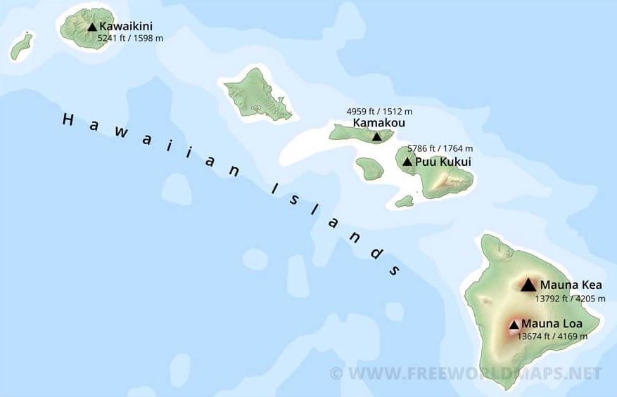
  • Mauna Loa: Hawaii’s biggest Volcano set to erupt

    mauna

    Mauna Loa, the world’s largest active volcano has erupted after 38 years, spewing ash and debris, and covering the sky of Hawaii’s Big Island.

    Where is Mauna Loa?

    mauna

    • Mauna Loa is one of five volcanoes that together make up the Big Island of Hawaii (biggest being the Mauna Kea).
    • It is the southernmost island in the Hawaiian archipelago.
    • It’s not the tallest (that title goes to) but it’s the largest and makes up about half of the island’s land mass.
    • It sits immediately north of Kilauea volcano, which is currently erupting from its summit crater.

    Do you know?

    Any volcano that has erupted within the Holocene period (in the last 11,650 years) is considered to be “active” by scientists. “Dormant” volcanoes are those active volcanoes which are not in the process of erupting currently, but have the potential to do so in the future.

    Why do volcanoes erupt?

    • The deeper one goes under the surface of the Earth towards its core, the hotter it gets.
    • The geothermal gradient, the amount that the Earth’s temperature increases with depth, indicates heat flowing from the Earth’s warm interior to its surface.
    • At a certain depth, the heat is such that it melts rocks and creates what geologists call ‘magma’.
    • Magma is lighter than solid rock and hence it rises, collecting in magma chambers.
    • Chambers that have the potential to cause volcanic eruptions are found at a relatively shallow depth, between six to ten km under the surface.
    • As magma builds up in these chambers, it forces its way up through cracks and fissures in Earth’s crust. This is what we call a volcanic eruption.
    • The magma that surfaces on the Earth’s crust is referred to as lava.

    Why is the eruption of Mauna Loa so explosive?

    • Eruptions vary in intensity and explosiveness, depending on the composition of the magma.
    • In simple terms, runny magma makes for less explosive volcanic eruptions that typically are less dangerous.
    • Since the magma is runny, gasses are able to escape, leading to a steady but relatively gentle flow of lava out of the mouth of the volcano.
    • The eruption at Mauna Loa is of this kind. Since the lava flows out at a slow pace, people typically have enough time to move out of the way
    • . Geologists are also able to predict the flow of the lava depending on the incline and exact consistency it has.

    How is vulcanism measured?

    • The Volcanic Explosivity Index (VEI) is a scale used to measure the explosivity of a volcano.
    • It has a range of 1 to 8 with a higher VEI indicating more explosivity.
    • While the VEI of the current eruption at Mauna Loa is not known yet, the previous eruption in 1984 was deemed to have a VEI of 0.


    Also read about the Pacific Ring of Fire.


    Click and get your FREE Copy of CURRENT AFFAIRS Micro Notes

    (Click) FREE1-to-1 on-call Mentorship by IAS-IPS officers | Discuss doubts, strategy, sources, and more

  • Places in news: Shiveluch Volcano

    shiveluch

    The Shiveluch volcano on the Kamchatka Peninsula in the Russian Far East has increased its activity and is now in danger of erupting violently.

    About Shiveluch

    • Shiveluch is one of the largest and most active volcanoes in Kamchatka, having erupted at least 60 times in the past 10,000 years.
    • Kamchatka is home to 29 active volcanoes, part of a vast belt of Earth known as the “Ring of Fire” which circles the Pacific Ocean and is prone to eruptions and frequent earthquakes.
    • It has two main parts: Old Shiveluch, which tops 3,283 metres (10,771 ft), and Young Shiveluch – a smaller, 2,800-metre peak protruding from its side.
    • Young Shiveluch lies within an ancient caldera – a large crater-like basin that likely formed when the older part underwent a catastrophic eruption at least 10,000 years ago.
    • It is this part that has become extremely active; the lava dome continues to grow and that stronger “fumarole activity” has been observed.


    Click and get your FREE Copy of CURRENT AFFAIRS Micro Notes

    (Click) FREE1-to-1 on-call Mentorship by IAS-IPS officers | Discuss doubts, strategy, sources, and more

  • Places in news: Sahel Region

    sahel

    French President Emmanuel Macron announced the end of the decade-long Operation Barkhane in Africa’s Sahel Region.

    Note the nations falling in Sahel Region.

    Sahel Region

    • The Sahel is the ecoclimatic and biogeographic realm of transition in Africa between the Sahara to the north and the Sudanian savanna to the south.
    • Having a semi-arid climate, it stretches across the south-central latitudes of Northern Africa between the Atlantic Ocean and the Red Sea.
    • The name is derived from the Arabic term for “coast, shore”; this is explained as being used in a figurative sense in reference to the southern edge of the vast Sahara.
    • The Sahel part includes from west to east parts of northern Senegal, southern Mauritania, central Mali, northern Burkina Faso, the extreme south of Algeria, Niger, the extreme north of Nigeria, the extreme north of Cameroon and the Central African Republic, central Chad, central and southern Sudan, the extreme north of South Sudan, Eritrea and the extreme north of Ethiopia.

    What is Operation Barkhane?

    • France began its military operations in Sahel in January 2013.
    • Titled Operation Serval, it was limited to targeting Islamic extremists linked to al-Qaeda who took control of northern Mali.
    • However, in 2014, the mission was scaled up, renamed Operation Barkhane and was aimed at counter-terrorism.
    • The objective was to assist local armed forces to prevent the resurgence of non-state armed groups across the Sahel region.
    • Around 4,500 French personnel were deployed with the local joint counter-terrorism force.


    (Click) FREE1-to-1 on-call Mentorship by IAS-IPS officers | Discuss doubts, strategy, sources, and more

  • Groundwater Extraction Lowest in 18 years

    groundwater

    Groundwater extraction in India saw an 18-year decline, according to an assessment by the Central Ground Water Board (CGWB).

    What is Groundwater?

    groundwater

    • Groundwater is the water found underground in the cracks and spaces in soil, sand and rock.
    • It is stored in and moves slowly through geologic formations of soil, sand and rocks called aquifers.
    • Aquifers are typically made up of gravel, sand, sandstone, or fractured rock, like limestone.
    • Water can move through these materials because they have large connected spaces that make them permeable.
    • Aquifers, hand-dug wells, and artesian wells are different types of sources of groundwater.

    Declining trend of groundwater extraction

    • The total annual groundwater recharge for the entire country is 437.6 billion cubic metres (bcm) in 2022.
    • However the extraction for entire country is only 239.16 bcm, according to the 2022 CGWB report.
    • By comparison, an assessment in 2020 found that the annual groundwater recharge was 436 bcm and extraction 245 bcm.
    • The 2022 assessment suggests that groundwater extraction is the lowest since 2004, when it was 231 bcm.

    Implications of the CGWB report

    • A detailed analysis of the assessment indicates increase in ground water recharge.
    • This is mainly attributed to:
    1. Increase in recharge from canal seepage,
    2. Return flow of irrigation water and
    3. Recharges from water bodies/tanks & water conservation structures.

    Significance of groundwater

    • Groundwater supplies drinking water to a sizeable population in India and almost 99% of the rural population.
    • It helps grow our food. 64% of groundwater is used for irrigation to grow crops.
    • It is an important component in many industrial processes.
    • It is a source of recharge for lakes, rivers, and wetlands.

    Why discuss this?

    • Depletion: People face serious water shortages because groundwater is used faster than it is naturally replenished.
    • Contamination: In other areas groundwater is polluted by human activities.

    Reasons for Depletion

    • Increased demand for water for domestic, industrial and agricultural needs and limited surface water resources lead to the over-exploitation of groundwater resources.
    • Limited storage facilities owing to the hard rock terrain, along with the added disadvantage of lack of rainfall, especially in central Indian states.
    • Green Revolution enabled water-intensive crops to be grown in drought-prone/ water deficit regions, leading to over-extraction of groundwater.
    • Frequent pumping of water from the ground without waiting for its replenishment leads to quick depletion.
    • Subsidies on electricity and high MSP for water-intensive crops is also leading reasons for depletion.
    • Inadequate regulation of groundwater laws encourages the exhaustion of groundwater resources without any penalty.
    • Deforestation, unscientific methods of agriculture, chemical effluents from industries, and lack of sanitation also lead to pollution of groundwater, making it unusable.
    • Natural causes include uneven rainfall and climate change that are hindering the process of groundwater recharge.

    Impact of groundwater depletion

    • Lowering of the water table: Groundwater depletion may lower the water table leading to difficulty in extracting groundwater for usage.
    • Reduction of water in streams and lakes: A substantial amount of the water flowing in rivers comes from seepage of groundwater into the streambed. Depletion of groundwater levels may reduce water flow in such streams.
    • Subsidence of land: Groundwater often provides support to the soil. When this balance is altered by taking out the water, the soil collapses, compacts, and drops leading to subsidence of land.
    • Increased cost for water extraction: As the depleting groundwater levels lower the water table, the user has to delve deep to extract water. This will increase the cost of water extraction.

    Regulation of Groundwater in India

    (1) Central Ground Water Authority (CGWA)

    • It has the mandate of regulating ground water development and management in the country.
    • It is constituted under the Environment (Protection) Act of 1986.
    • CGWA issues advisories, public notices and grant No Objection Certificates (NOC) for ground water withdrawal.

    (2) National Aquifer Mapping and Management Programme (NAQUIM)

    • The NAQUIM is an initiative of the Ministry of Jal Shakti for mapping and managing the entire aquifer systems in the country.
    • It maintains the Hydrological Map of India.

    (3) Atal Bhujal Yojana 

    • It is a Central Sector Scheme, for sustainable management of groundwater resources with community participation in water-stressed blocks.

    Way Forward

    • Routine survey: There should be regular assessment of groundwater levels to ensure that adequate data is available for formulating policies and devising new techniques.
    • Assessment of land use pattern: Studies should be carried out to assess land use and the proportion of agricultural land falling under overt-exploited units.
    • Changes in farming methods: To improve the water table in those areas where it is being overused, on-farm water management techniques and improved irrigation methods should be adopted.
    • Reforms in power supply subsidies: The agricultural power-pricing structure needs to be revamped as the flat rate of electricity adversely affects the use of groundwater.
    • Monitoring extraction: There should be a policy in place to monitor the excessive exploitation of groundwater resources to ensure long-term sustainability.


    Click and get your FREE Copy of CURRENT AFFAIRS Micro Notes

  • What are Eclipses?

    eclipse

    India recently witnessed a partial solar eclipse. Let’s take a look over all dynamics of Eclipses.

    What are Eclipses?

    • An eclipse takes place when one heavenly body such as a moon or planet moves into the shadow of another heavenly body.
    • There are two types of eclipses on Earth: an eclipse of the Moon and an eclipse of the Sun.

    [I] A Lunar Eclipse

    eclipse

    • The moon moves in an orbit around Earth, and at the same time, Earth orbits the sun. Sometimes Earth moves between the sun and the moon.
    • When this happens, Earth blocks the sunlight that normally is reflected by the moon. (This sunlight is what causes the moon to shine.)
    • Instead of light hitting the moon’s surface, Earth’s shadow falls on it. This is an eclipse of the moon — a lunar eclipse.
    • A lunar eclipse can occur only when the moon is full. (But not every full moon is also a lunar eclipse. Can you guess why?)

    Observing a Lunar Eclipse

    • A lunar eclipse can be seen from Earth at night.
    • A lunar eclipse usually lasts for a few hours.
    • At least two partial lunar eclipses happen every year, but total lunar eclipses are rare.

    There are two types of lunar eclipses: total lunar eclipses and partial lunar eclipses.

    • A total lunar eclipse occurs when the moon and the sun are on exact opposite sides of Earth. Although the moon is in Earth’s shadow, some sunlight reaches the moon.  The sunlight passes through Earth’s atmosphere, which causes Earth’s atmosphere to filter out most of the blue light. This makes the moon appear red to people on Earth.
    • A partial lunar eclipse happens when only a part of the moon enters Earth’s shadow. In a partial eclipse, Earth’s shadow appears very dark on the side of the moon facing Earth. What people see from Earth during a partial lunar eclipse depends on how the sun, Earth and moon are lined up.
    • In a penumbral lunar eclipse, only the more diffuse outer shadow of Earth – the penumbra – falls on the moon’s face. This third kind of lunar eclipse is much more subtle, and much more difficult to observe than either a total or partial eclipse of the moon.

    [II] A Solar Eclipse

    eclipse

    • Sometimes when the moon orbits Earth, it moves between the sun and Earth.
    • When this happens, the moon blocks the light of the sun from reaching Earth.
    • This causes an eclipse of the sun or solar eclipse.
    • During a solar eclipse, the moon casts a shadow onto Earth.

    There are three types of solar eclipses.

    The first is a Total Solar Eclipse

    • A total solar eclipse is only visible from a small area on Earth.
    • The people who see the total eclipse are in the centre of the moon’s shadow when it hits Earth.
    • The sky becomes very dark as if it were night. For a total eclipse to take place, the sun, moon and Earth must be in a direct line.

    The second type is a Partial Solar Eclipse

    • This happens when the sun, moon and Earth are not exactly lined up.
    • The sun appears to have a dark shadow on only a small part of its surface.

    The third type is an Annular Solar Eclipse

    • An annular eclipse happens when the moon is farthest from Earth. Because the moon is farther away from Earth, it seems smaller. It does not block the entire view of the sun. The moon in front of the sun looks like a dark disk on top of a larger sun-coloured disk. This creates what looks like a ring around the moon.
    • During a solar eclipse, the moon casts two shadows on Earth. The first shadow is called the Umbra. This shadow gets smaller as it reaches Earth. It is the dark centre of the moon’s shadow.
    • The second shadow is called the Penumbra. The penumbra gets larger as it reaches Earth. People standing in the penumbra will see a partial eclipse. People standing in the umbra will see a total eclipse.

    Observing a Solar Eclipse

    • Solar eclipses happen once every 18 months.
    • Unlike lunar eclipses, solar eclipses only last for a few minutes.

    Why don’t solar eclipses happen at every New Moon?

    • The reason is that the Moon’s orbit tilts 5° to Earth’s orbit around the Sun.
    • Astronomers call the two intersections of these paths nodes.
    • Eclipses only occur when the Sun lies at one node and the Moon is at its New (for solar eclipses) or Full (for lunar eclipses) phase.
    • During most (lunar) months, the Sun lies either above or below one of the nodes, and no eclipse happens.

    [III] Planet Transits

    • When a planet comes between Earth and the Sun, it is called a transit.
    • The only 2 planets that can be seen transiting the Sun from Earth are Venus and Mercury because they are the only planets that orbit inside Earth’s orbit.
    • From 2000–2199, there will be 14 transits of Mercury.
    • However, Venus transits are even rarer with only 2 this century, in 2004 and 2012.


    UPSC 2023 countdown has begun! Get your personal guidance plan now! (Click here)

  • Stressed ecology of Bay of Bengal

    Bay of BengalContext

    • At the fourth BIMSTEC summit, Prime Minister Narendra Modi announced the opening of the Centre for Bay of Bengal Studies (CBS) at Nalanda University. The launch of the CBS has once again demonstrated India’s commitment to advancing constructive agendas by forging connections and setting up platforms for all those with an interest in the of Bay of Benagl.

    Bay of BengalWhy Bay of Bengal is so important?

    • Commerce hub: The Bay has long been a major commerce hub for the Indian Ocean. It created a conduit between the East and the West in terms for trade and culture.
    • Emerging arena of maritime warfare: An Indo-Pacific orientation and the realignment of global economic and military power towards Asia have had a considerable impact on the Bay region.
    • Communication and Energy: The key sea lanes of communication in this area are lifelines for global economic security and are crucial to the energy security that powers the economies of many countries in the region.Further, non-traditional dangers including terrorism and climate change have become more prevalent.
    • Under water resources: The Bay also provides an opportunity for greater regional cooperation in the environmentally friendly exploration of marine and energy resources. The Bay has a biodiverse marine environment.
    • Fresh water resources: It receives the water from some of the world’s largest rivers. It is a partially enclosed sea that has given rise to several geological characteristics.
    • Ecology: It is home to many rare and endangered marine species and mangroves, which are essential to the survival of the ecology and the fishing sector.

    Bay of BengalWhy ecology in the region is under threat?

    The region’s maritime environment has changed as are result of major powers expanding their economic and geopolitical influence.

    • Competition: Political and cultural engagement, together with economic competition, have taken on new dimensions. More crucially, the Bay’s ecosystem is going through an unprecedented crisis brought on by widespread environmental exploitation and geopolitical unrest.
    • Resource exploitation: Species extinction is a result of careless exploitation of the maritime environment, which has severe consequences on biodiversity. Problems such as population growth, altered land use, excessive resource exploitation, salinity, sea level rise, and climate change are exerting significant strain on the Bay’s environment.
    • Water pollution: Operational discharge from small and medium feeder ships, shipping collisions, unintentional oil spills, industrial waste, pollution, and the accumulation of non- biodegradable plastic litter are all contributing to the deterioration of the Bay.
    • Declining ecology: A dead-zone has formed, and the mangrove trees that protect the shore from the fury of nature are under more threat than ever.

    What could be the Solutions?

    For a better knowledge of challenges, and strategies to overcome them for the sustainable development of the region, more focused and inter-disciplinary study is required on these issues.

    • Centre for Bay of Bengal studies: By founding the CBS, Nalanda University has already started its journey and given the nation a unique interdisciplinary research centre devoted to Bay focused teaching, research, and capacity building. Additionally, scholars from many countries and academic streams are already participating in CBS’s first certificate programme on the Bay.
    • Inter-governmental cooperation: It is essential that nautical neighbours develop a partnership and cooperate because of the maritime domain’s interrelated and interdependent nature, transnational character, and cross-jurisdictional engagement of various governments and diverse organisations and enterprises.
    • Maritime connectivity: A few concerns that need immediate attention include expanding cooperation in maritime safety and security, enhancing cooperation on maritime connectivity and the ease of maritime transit, and boosting investment possibilities in the maritime connectivity sector.
    • Illegal activities: The latter subject involves addressing non-traditional threats and fostering group efforts to reduce illicit, unreported, and unregulated fishing.
    • Data sharing: Standardising and harmonising data reporting.
    • Balanced approach: Furthermore regional marine entities should strive to balance opportunities and goals on a national, regional, and international scale.
    • Investment in R&D: Littoral governments need to support and promote skill-building, research, and training.

    Conclusion

    • Countries in the Bay of Bengal need to mobilise investments, manage maritime affairs more effectively. Alternative lifestyle should be explored. The cooperation of all member states, for information gathering, sharing and result oriented actions is crucial in protecting the ecology of Bay of Bengal.

    Mains Question

    Q.Countries in the Indian subcontinent are developing rapidly, putting serious stress on the environment of the Bay of Bengal.Mention the challenges and suggest solutions.

    UPSC 2022 countdown has begun! Get your personal guidance plan now! (Click here)

  • Southwest Monsoon begins early Withdrawal/Retreat

    The southwest monsoon rainfall, 7% more than normal, has started to withdraw.

    What is Monsoon Withdrawal/Retreat?

    • In India, retreating monsoon is the withdrawal of south-west monsoon winds from North India.
    • The withdrawal is gradual and takes about three months.
    • With the retreat of the monsoons, the clouds disappear and the sky becomes clear. The day temperature starts falling steeply.
    • Monsoon rains weaken all over India except few southeastern states.
    • It is helpful in Rabi crop cultivation.

    Factors affecting the retreat

    Two predominant factors cause the phenomenon:

    (1) Land topography

    • First, the low mountain range in each region runs from north to south, shielding it from west-bound winds that trigger summer monsoon.
    • After summer, the range aids in the ‘orographic lift’ or rising of east-bound air mass from a lower to higher elevation, forming clouds and resulting in rain.

    (2) Atmospheric convection

    • The second factor is atmospheric convection or vertical movement of air.
    • As the earth is heated by the sun, different surfaces absorb different amounts of energy and convection may occur where the surface heats up very rapidly.
    • As the surface warms, it heats the overlying air, which gradually becomes less dense than the surrounding air and begins to rise.
    • This condition is more favorable from September to February because of the role played by sea surface temperature or water temperature.

    Immediate factors influencing withdrawal

    • The withdrawal of the monsoon is based on meteorological conditions such as-
    1. Anti-cyclonic circulation (dry air that is the opposite of a cyclone)
    2. Absence of rain in the past five days and
    3. Dry weather conditions over the region

    When does it occur?

    • The monsoon withdrawal is a long-drawn process and extends into mid-October, though the IMD considers September 30 to be the final day of the season over India.
    • The rain after that is categorised as “post-monsoon” rainfall.

    Try this PYQ:

    Q.The seasonal reversal of winds is the typical characteristic of:

    (a) Equatorial climate

    (b) Mediterranean climate

    (c) Monsoon climate

    (d) All of the above climates


    [wpdiscuz-feedback id=”9s1wlwig7j” question=”Please leave a feedback on this” opened=”1″]Post your answers here.[/wpdiscuz-feedback]


    Also read:

    Various terms related to Indian Monsoon


    UPSC 2023 countdown has begun! Get your personal guidance plan now! (Click here)

  • What is Karoo-Ferrar Large Igneous Province?

    karoo

    A new study shows that a decline in continental plate movement likely controlled the onset and duration of many of the major volcanic events throughout Earth’s history.

    Why is the news?

    • Previous studies have linked major volcanic eruptions with past mass extinctions and disturbances in the global climatic, environmental and the carbon cycle.
    • Large igneous province volcanism, formations due to major volcanic eruptions occurring throughout Earth’s history, released large quantities of greenhouse gasses and toxic compounds into the atmosphere.
    • The sea warmed up by 4°C to 10°C, even at low- to mid-latitudes, the study noted.
    • Increased acidic levels and a lack of oxygen drove major ocean extinctions.
    • Large-scale volcanism took place in southern Africa, Antarctica and Australia. This is known as the Karoo-Ferrar Large Igneous Province.

    About Karoo-Ferrar Large Igneous Province

    • The Karoo and Ferrar Large Igneous Provinces (LIPs) are two large igneous provinces in Southern Africa and Antarctica respectively, collectively known as the Karoo-Ferrar, Gondwana, or Southeast African LIP associated with the initial break-up of the Gondwana supercontinent.
    • Its flood basalt mostly covers South Africa and Antarctica but portions extend further into southern Africa and into South America, India, Australia and New Zealand.
    • Karoo-Ferrar formed just prior to the breakup of Gondwana in the Lower Jurassic epoch, about 183 million years ago.
    • This time corresponds to the early Toarcian anoxic event and the Pliensbachian-Toarcian extinction.


    UPSC 2023 countdown has begun! Get your personal guidance plan now! (Click here)

  • In news: Continental Drift Theory

    This newscard is an excerpt from the original article published in TH which talks about the specie Lemurs who are supposed to jump into seas to find India which got drifted away from the Madagascar.

    Study on Lemurs

    • Many life forms in Madagascar have affinities to lineages found in India (3,800 km away) rather than Africa (413 km). This posed a ‘difficult enigma’ to naturalists.
    • One such species is the Lemurs.
    • We most likely see lemurs in a Hollywood animation movie; singing, dancing and playing pranks.
    • Zoologists was perplexed by the presence of lemurs, their relatives, and their fossils in Madagascar and India, but not in nearby Africa or the Middle East.
    • In the 1860s, he proposed that a large island or continent must have once existed between India and Madagascar, serving as a land bridge.
    • Over time, this island had sunk. He called this proposed island Lemuria.

    Existence of such Island in Indian legends

    • Tamil revivalists such as Devaneya Pavanar also took up the idea, in the form of a Tamil civilisation, lost to the sea as described in literature and in Pandyan legends.
    • They called this submerged continent Kumari Kandam.

    Basis of this legend: Continental Drift Theory

    • In the early 20th century, German geologist Alfred Wegener published a paper on his theory called continental drift.
    • It is a hypothesis that Earth’s continents were moving across Earth, and sometimes, even colliding into one another.
    • According to Wegener’s theory, Earth’s continents were once joined as a single, giant landmass, which he called Pangaea.
    • But over time, Pangaea broke apart and formed the continents as we know them today.
    • Wegener couldn’t explain why this phenomenon was happening, so at the time, his theory was heavily criticized by his colleagues.
    • But over the years, technological advances allowed scientists to study the Earth more closely, and geologists started to build on Wegener’s theory.

    Rise over to Plate Tectonics

    • Discoveries like seafloor spreading helped explain the “why” behind continental movement, and eventually, Wegener’s initial continental drift theory morphed into plate tectonic theory.
    • And now, the idea that Earth’s crust is slowly moving beneath our feet is widely accepted.

    The Seven Major Tectonic Plates

    There are seven major plates, and dozens of minor plates, that make up the outer crust of the Earth. The big seven are:

    1. North American plate
    2. Eurasian plate
    3. Pacific plate
    4. South American plate
    5. African plate
    6. Indo-Australian plate
    7. Antarctic plate


    The areas between these plates are known as plate boundaries, and their interactions cause some crazy things to happen on Earth’s surface.

    There are three types of plate boundaries:

    1. Divergent boundary
    • A divergent boundary is when two plates move away from each other, which creates a fracture in the lithosphere.
    • A well-known divergent boundary is the Mid-Atlantic Ridge, which runs approximately 10,000 miles from the Arctic Ocean all the way down to the south of Africa.
    1. Convergent boundary
    • A convergent boundary is when two plates collide with one another.
    • If the collision is between oceanic crust and continental crust, the denser oceanic crust slides underneath the other plate, which is a process known as subduction.
    • When two continental crusts collide, the rock folds and lifts at the boundary, creating mountains like the Himalayas (where the Indian plate meets the Eurasian plate).
    1. Transform Boundary
    • When two plates move parallel to one another, their meeting point is called a transform boundary. The friction causes tension.
    • Eventually, that tension needs to be released, which can cause earthquakes.
    • The San Andreas Fault is a well-known major transform boundary between the North American and Pacific plates—it caused the infamous San Francisco earthquake of 1906.

    How do we apply this theory here?

    • A landmass called Gondwana, split into two 165 million years ago — one containing what is now Africa and South America, the other comprising India, Madagascar, Australia and Antarctica.
    • Around 115 million years ago, Madagascar and India together broke free.
    • Around 88 million years ago, India moved northward, dropping a few parcels of land along the way to form Seychelles.
    • It joined the Eurasian mass 50 million years ago giving rise to the Himalayas and South Asia that we are familiar with.
    • Around 115 million years ago, it was the dinosaurs that ruled. Many life forms had not even evolved.

    Substantiation to this study

    (1) Fossil study

    • Supporting the Gondwana breakup, dinosaur fossils found in India and Madagascar are closely related and do not resemble species found in Africa and Asia.
    • Fragments of Laplatosaurus madagascarensis have been found in both India and Madagascar.

    (2) Molecular clocks

    • A powerful technique, the molecular clock, is used to estimate the time when two forms of life diverged from each other.
    • It is based on the observation that evolutionary changes in the sequence of an RNA or a protein molecule occur at a fairly constant rate.
    • The difference in the amino acids of, say the haemoglobin of two animals can tell you how long ago their lineages diverged.
    • Molecular clocks corroborate well with other evidence, such as the fossil record.
    • South India and Sri Lanka have only two genuses of the cichlid family of freshwater and brackish-water fishes — the Etroplus (a food fish in Kerala, where it is called pallathi) and Pseudetroplus.
    • Molecular comparisons show that the nearest relatives of Etroplus are found in Madagascar, and their common ancestor diverged from African cichlids 160 million years ago.

    India’s pivotal position

    • India occupies a pivotal position in the distribution of life forms in Asia, Madagascar and Africa. Gondwana creatures moved out of India.
    • Others crossed over to stay. For example, Asian freshwater crabs (Gecarcinucidae) are now found all over Southeast Asia but their most recent common ancestor evolved in India.
    • Fossil finds in the Vastan lignite mine in Gujarat by researchers have identified the earliest Indian mammal, a species of bat, and the earliest euprimate, a primitive lemur.
    • These were dated 53 million years ago, around the time (or just before) the India-Eurasian plates collided.

    What about the lemurs?

    • Madagascar is a large island, with a variety of climatic conditions. Evidence favours an ancestor primate crossing over from Africa.
    • No monkey, ape or large predator managed the crossing, so dozens of lemur species proliferated.
    • In India, we have the lorises, which are the closest extant relatives of the lemurs.
    • These are shy, nocturnal forest dwellers, with large, appealing eyes.
    • They are also believed to have survived oceanic rides from Africa.
    • They are mostly found in the Northeastern States (slow loris), and where Karnataka, Kerala and Tamil Nadu meet (slender loris).


    UPSC 2023 countdown has begun! Get your personal guidance plan now! (Click here)
  • Derecho: A storm that turned the sky green in the US

    States of Nebraska, Minnesota and Illinois in the US were hit by a storm system called a Derecho which turned the skies green.

    What is a Derecho?

    • A derecho is a widespread, long-lived, straight-line windstorm that is associated with a band of rapidly moving showers or thunderstorms.
    • The name comes from the Spanish word ‘la derecha’ which means ‘straight’.
    • Straight-line storms are those in which thunderstorm winds have no rotation unlike a tornado.
    • Being a warm-weather phenomenon, a derecho generally – not always – occurs during summertime beginning May, with most hitting in June and July.
    • However, they are a rare occurrence as compared to other storm systems like tornadoes or hurricanes.

    Why does the sky turn green during the derecho?

    • Severe thunderstorms result in a ‘green sky’ due to light interacting with the huge amount of water they hold.
    • The big raindrops and hail scatter away all but the blue wavelengths due to which primarily blue light penetrates below the storm cloud.
    • This blue then combines with the red-yellow of the afternoon or the evening sun to produce green.

    Are there different types of derechos?

    They fall into three categories – progressive, serial and hybrid.

    1. Progressive derecho is associated with a short line of thunderstorms that may travel for hundreds of miles along a relatively narrow path. It is a summer phenomenon.
    2. Serial derecho, on the other hand, has an extensive squall line – wide and long – sweeping across a large area. It usually occurs during spring or fall.
    3. Hybrid derecho are that ones have the features of both progressive and serial derechos.

    Where do derechos usually occur?

    • They mostly occur across central and eastern parts of the United States.
    • Derechos have also been documented elsewhere across the world.
    • In 2010, Russia witnessed its first documented derecho.
    • They have also swept through Germany and Finland, and more recently in Bulgaria and Poland.


    UPSC 2023 countdown has begun! Get your personal guidance plan now! (Click here)