💥Join UPSC 2027,2028 Mentorship (July Batch) + XFactor Notes & Microthemes PDF

Subject: Geographical Features

  • Understanding Summer Solstice: Longest Day of the Year

    summer solstice

    Central Idea

    • The summer solstice, also known as the longest day of the year, occurs on June 21st for those living north of the Equator.
    • This article explores the significance of the summer solstice, the reasons behind its occurrence, and the effects it has on different parts of the world.

    What is Summer Solstice?

    • The summer solstice is the moment when the Earth’s axial tilt is most inclined towards the Sun.
    • It occurs annually on or around June 21st in the Northern Hemisphere.
    • During the summer solstice, the Sun follows its highest and longest path across the sky.
    • This results in an extended duration of daylight hours, making it the longest day of the year.

    Factors Influencing the Summer Solstice

    • Earth’s Axial Tilt: The Earth’s axis is tilted relative to its orbit around the Sun, at an angle of approximately 23.5 degrees.
    • Tropic of Cancer: The summer solstice takes place when the Sun is directly over the Tropic of Cancer, located at 23.5 degrees north latitude.
    • Seasonal Variations: The tilt of the Earth’s axis causes different latitudes to receive varying amounts of sunlight throughout the year.

    Sunlight Distribution in the Hemispheres

    • The Northern Hemisphere receives the maximum amount of sunlight during the summer solstice, typically on June 20, 21, or 22.
    • In contrast, the Southern Hemisphere experiences its peak sunlight during the winter solstice, which occurs on December 21, 22, or 23.

    Cultural Significance and Celebrations

    • The summer solstice holds cultural and religious significance in various civilizations throughout history.
    • Festivals and rituals often commemorate this astronomical event, symbolizing the triumph of light and fertility.
    • People around the world celebrate the summer solstice through festivals, bonfires, music, dancing, and outdoor activities.
    • Notable celebrations include the Summer Solstice Stonehenge Festival in England and the Midnight Sun Festival in Norway.

    Back2Basics: Solstices and Equinoxes

    Summer Solstice Winter Solstice Equinoxes
    Date Around June 21st Around December 21st Around March 20th and September 22nd
    Hemisphere Northern Northern Global (Equal duration of day and night)
    Day Length Longest day and shortest night Shortest day and longest night Equal day and night duration
    Sun’s Path Highest arc in the sky Lowest arc in the sky Intermediate arc in the sky
    Season Summer Winter Spring and Autumn
    Axial Tilt North Pole tilted towards the Sun South Pole tilted towards the Sun No tilt, relative to the Sun
    Daylight Hours Maximum Minimum Approximately equal
    Cultural Significance Celebrated as the triumph of light, festivals, and rituals Celebrated as the return of light, festivals, and rituals Symbolizes balance and transition, celebrated by various cultures


  • Places in news: Brahmani Natural Arch

    brahmani arch

    Central Idea

    • The Geological Survey of India (GSI) plans to declare the ‘Brahmani Natural Arch’ in Kanika range of Sundargarh forest division of Odisha as a Geo Heritage Site.
    • This natural arch is believed to date back to the Jurassic period and would be the largest natural arch in India with the Geo Heritage tag.

    Brahmani Natural Arch

    • The oval-shaped arch has a base length of 30 meters and a height of 12 meters.
    • The alcove of the arch has a maximum height of 7 meters and a width of 15 meters.
    • India currently has two other natural arches, located at Tirumala hills in Tirupati and Andaman and Nicobar, but both are smaller than the one in Sundargarh.

    Its formation

    • The natural arch is composed of ferruginous sandstone from the Upper Kamthi formation.
    • It dates back to the lower to middle Jurassic age, approximately 184 to 160 million years old.
    • Research on the geological significance of the site began in 2017 after its discovery during coal exploration in the district.

    Awareness and Preservation Efforts

    • The GSI state unit and Sundargarh forest division conducted an awareness drive in the district to promote the protection of the natural arch.
    • Steps are being taken to promote the proposed geo-heritage site as a cultural pride and potentially name it ‘Brahmani natural arch.’
    • The site could be promoted and preserved as an eco-tourism destination.

    Back2Basics:

    Geological Heritage Sites in India
    Andhra Pradesh Mangampeta Volcanogenic bedded Barytes (Cuddapah Dist.), Eparchaean Unconformity (Chittor Dist.), Natural Geological Arch in Tirumala Hills (Chittor Dist.), Erra Matti Dibbalu located between Vishakhapatnam and Bhimunipatnam.
    Maharashtra Lonar Lake (Buldana Dist.)
    Kerala Laterite near Angadipuram PWD rest house premises (Malapuram Dist.), Varkala Cliff Section (Thiruvanatapuram Dist.)
    Chattisgarh Lower Permian Marine bed at Manendragarh (Surguja Dist.)
    Tamil Nadu Fossil wood near Tiruvakkarai (South Arcot Dist.), National fossil wood park in Sattanur (Tiruchirapalli Dist.), Charnockite in St. Thomas Mount (Madras), Badlands of Karai Formation with Cretaceous fossils along Karai – Kulakkalnattam Section (Perambalur District)
    Karnataka Columnar Lava in St. Mary Island (Udupi Dist.), Pillow lavas near Mardihalli (Chitradurga Dist.), Peninsular Gneiss in Lalbagh (Bangalore), Pyroclastics & Pillow lavas in Kolar Gold fields (Kolar Dist.)
    Gujarat Sedimentary Structures – Eddy Markings in Kadan Dam (Panch Mahals Dist.)
    Himachal Pradesh Siwalik Fossil Park (Saketi, Sirmur dt.)
    Rajasthan Sendra Granite (Pali Dist.), Barr Conglomerate (Pali Dist.), Stromatolite Fossil Park near Jharmarkotra Rock Phosphate deposit (Udaipur Dist.), Gossan in Rajpura-Dariba Mineralised belt (Udaipur Dist.), Akal Fossil Wood Park (Jaisalmer Dist.)
    Odisha Pillow Lava in iron ore belt at Nomira (Keonjhar dist.)
    Jharkhand Plant Fossil bearing Inter-trappean beds of Rajmahal Formation around Mandro (Sahibganj dist.)
    Nagaland Nagahill Ophiolite Site near Pungro
    Sikkim Stromatolite bearing Dolomite/Limestone of Buxa Formation at Mamley, near Namchi (South district), Stromatolite bearing Dolomite / Limestone of Buxa Formation, Sikkim


    https://www.newindianexpress.com/cities/bhubaneswar/2023/jun/11/gsi-proposes-geo-heritage-tag-for-jurassic-age-natural-arch-in-odisha-2583901.html

  • Monsoon onset in Kerala on June 4

    monsoon

    Central Idea: The monsoon is likely to set in over Kerala with a “slight delay” on June 4, the India Meteorological Department (IMD) said. The usual onset date over Kerala is June 1, within a seven-day window.

    What does the “Onset of Monsoon” mean?

    • The onset of the monsoon over Kerala marks the beginning of the four-month, June to September southwest monsoon season over India.
    • It brings more than 70 per cent of the country’s annual rainfall.
    • It marks a significant transition in the large-scale atmospheric and ocean circulations in the Indo-Pacific region.
    • The IMD announces it only after certain newly defined and measurable parameters, adopted in 2016, are met.
    • The onset is a significant day in India’s economic calendar.

    How does IMD predict the monsoon?

    • Broadly, the IMD checks for the consistency of rainfall over a defined geography, its intensity, and wind speed:
    1. Rainfall: The IMD declares the onset of the monsoon if at least 60% of 14 designated meteorological stations in Kerala and Lakshadweep record at least 2.5 mm of rain for two consecutive days at any time after May 10.
    2. Wind field: The depth of westerlies should be upto 600 hectopascal (1 hPa is equal to 1 millibar of pressure) in the area bound by the equator to 10ºN latitude, and from longitude 55ºE to 80ºE. The zonal wind speed over the area bound by 5-10ºN latitude and 70-80ºE longitude should be of the order of 15-20 knots (28-37 kph) at 925 hPa.
    3. Heat: The INSAT-derived Outgoing Longwave Radiation (OLR) value (a measure of the energy emitted to space by the Earth’s surface, oceans, and atmosphere) should be below 200 watt per sq m (wm2) in the box confined by 5-10ºN latitude and 70-75ºE latitude.
    • The onset is not officially declared until the prescribed conditions (above) are met.

    Factors considered by IMD

    • The IMD uses a specialised model that forecasts the arrival dates within a four-day window.
    • It uses six predictors:
    1. Minimum temperatures over northwest India
    2. Pre-monsoon rainfall peak over south Peninsula
    3. Outgoing long-wave radiation (OLR) over the South China Sea
    4. Lower tropospheric zonal wind over the southeast Indian Ocean
    5. Upper tropospheric zonal wind over the east equatorial Indian Ocean, and
    6. OLR over the southwest Pacific region

    Back2Basics: Long Period Average (LPA)

    • The IMD predicts a “normal”, “below normal”, or “above normal” monsoon in relation to a benchmark “long period average” (LPA).
    • The LPA of rainfall is the rainfall recorded over a particular region for a given interval (like month or season) average over a long period like 30 years, 50 years, etc.
    • LPA refers to the average rainfall recorded from June to September for the entire country, the amount of rain that falls every year varies from region to region and from month to month.
    • The IMD’s prediction of a normal monsoon is based on the LPA of the 1971-2020 period, during which India received 87 cm of rain for the entire country on average.
    • It has in the past calculated the LPA at 88 cm for the 1961-2010 period, and at 89 cm for the period 1951-2000.

    Why LPA is needed?

    • The IMD records rainfall data at more than 2,400 locations and 3,500 rain-gauge stations.
    • Because annual rainfall can vary greatly not just from region to region and from month to month, but also from year to year within a particular region or month.
    • An LPA is needed to smooth out trends so that a reasonably accurate prediction can be made.
    • A 50-year LPA covers for large variations in either direction caused by freak years of unusually high or low rainfall, as well as for the periodic drought years.
    • It also takes into account the increasingly common extreme weather events caused by climate change.

    Range of normal rainfall

    The IMD maintains five rainfall distribution categories on an all-India scale. These are:

    1. Normal or near normal, when the percentage departure of actual rainfall is +/-10% of LPA, that is, between 96-104% of LPA;
    2. Below normal, when departure of actual rainfall is less than 10% of LPA, that is 90-96% of LPA;
    3. Above normal, when actual rainfall is 104-110% of LPA;
    4. Deficient, when departure of actual rainfall is less than 90% of LPA; and
    5. Excess, when the departure of actual rainfall is more than 110% of LPA.


    Get an IAS/IPS ranker as your personal mentor for UPSC 2024 | Schedule your FREE session and get the Prelims prep Toolkit!

  • Palghat Gap: A break in the Western Ghats

    palghat

    Central Idea: The article discusses the Palghat (Palakkad) Gap, a significant corridor in the Western Ghats of India. It provides information about the geological origin of the gap.

    What is Palghat Gap?

    • The Palghat Gap is a 40 km wide corridor in the Western Ghats, known for its steep hills and serving as a gateway to Kerala.
    • It is a crucial passage for roads and railways connecting Coimbatore and Palakkad.
    • The Bharathappuzha River flows through the Palghat Gap.
    • The vegetation in the gap is classified as dry evergreen forest, different from the tropical rainforests of the Western Ghats.
    • The Palghat Gap marks a distinct divide in the flora and fauna of the region.

    Geological origin of the Palghat Gap

    • The Palghat Gap is a geological shear zone running from east to west.
    • Shear zones are weak regions in the Earth’s crust, occasionally causing tremors in the Coimbatore region.
    • The formation of the Palghat Gap occurred when the continental shelves shifted after the separation of Australia and Africa from the Gondwana landmass.
    • India and Madagascar were connected until volcanic activity led to their split, with a similar gap called the Ranotsara Gap in Madagascar.

    Biogeographic distinctions and ancient history

    • The biogeographic distinctions in species north and south of the Palghat Gap may be attributed to an ancient river or an incursion of the sea in the distant past.
    • Elephant populations on the Nilgiris side of the gap have different mitochondrial DNA from elephants in the Anamalai and Periyar sanctuaries.
    • DNA analysis of the White-bellied Shortwing, an endemic bird species, shows divergence between populations in the Nilgiris and the Anamalai regions.

    Biodiversity south of the Palghat Gap

    • The southern region of the Western Ghats, located south of the Palghat Gap, exhibits high species richness and phylogenetic diversity.
    • A recent study reports over 450 tree species, including ancient species like Magnolia champaca, dating back 130 million years.
    • The warm weather and moist air of the southern Western Ghats support a diverse range of life, making it an island refuge during cycles of ice ages and droughts.
    • The southern Western Ghats receive rainfall more evenly throughout the year compared to the northern region.

    Back2Basics: Western Ghats

    • The Western Ghats, also known as the Sahyadri mountain range, is a UNESCO World Heritage Site and one of the 36 biodiversity hotspots in the world.
    • It spans an area of 160,000 sq. km. and stretches for 1,600 km parallel to the western coast of the Indian peninsula, passing through the states of Gujarat, Maharashtra, Goa, Karnataka, Kerala, and Tamil Nadu.
    Description
    Flora and Fauna The Western Ghats are home to a rich diversity of flora and fauna, including over 7,402 species of flowering plants, 1,814 species of non-flowering plants, 139 mammal species, 508 bird species, 227 reptile species, 179 amphibian species, 290 freshwater fish species, and 6,000 insect species.
    Geological Significance The Western Ghats, known as the “Great Escarpment of India,” are older than the Himalayas. They influence India’s monsoon weather patterns by intercepting rain-laden monsoon winds from the southwest during late summer.
    Geographic Features Stretching north to south along the western edge of the Deccan Plateau, the Western Ghats separate the plateau from the narrow coastal plain called the Western Coastal Plains, which lies along the Arabian Sea.
    Catchment Area The Western Ghats cover a vast catchment area for complex riverine drainage systems, contributing to almost 40% of India’s total drainage. The range acts as a barrier, blocking southwest monsoon winds from reaching the Deccan Plateau.

    Get an IAS/IPS ranker as your personal mentor for UPSC 2024 | Schedule your FREE session and get the Prelims prep Toolkit!

  • Over 19,000 Seamounts discovered

    seamount

    Central Idea: Scientists have reported finding 19,325 new seamounts after poring through new high-resolution data. A study had already mapped 24,000 seamounts across the world’s oceans.

    Why study this?

    • The recent discovery of new seamounts was made possible by advancements in altimetry for gravity-field mapping, which improved spatial coverage.
    • The CryoSat-2, Envisat, Jason-1 geodetic missions, and the SARAL satellite developed by India and France contributed to these advancements.

    What are Seamounts?

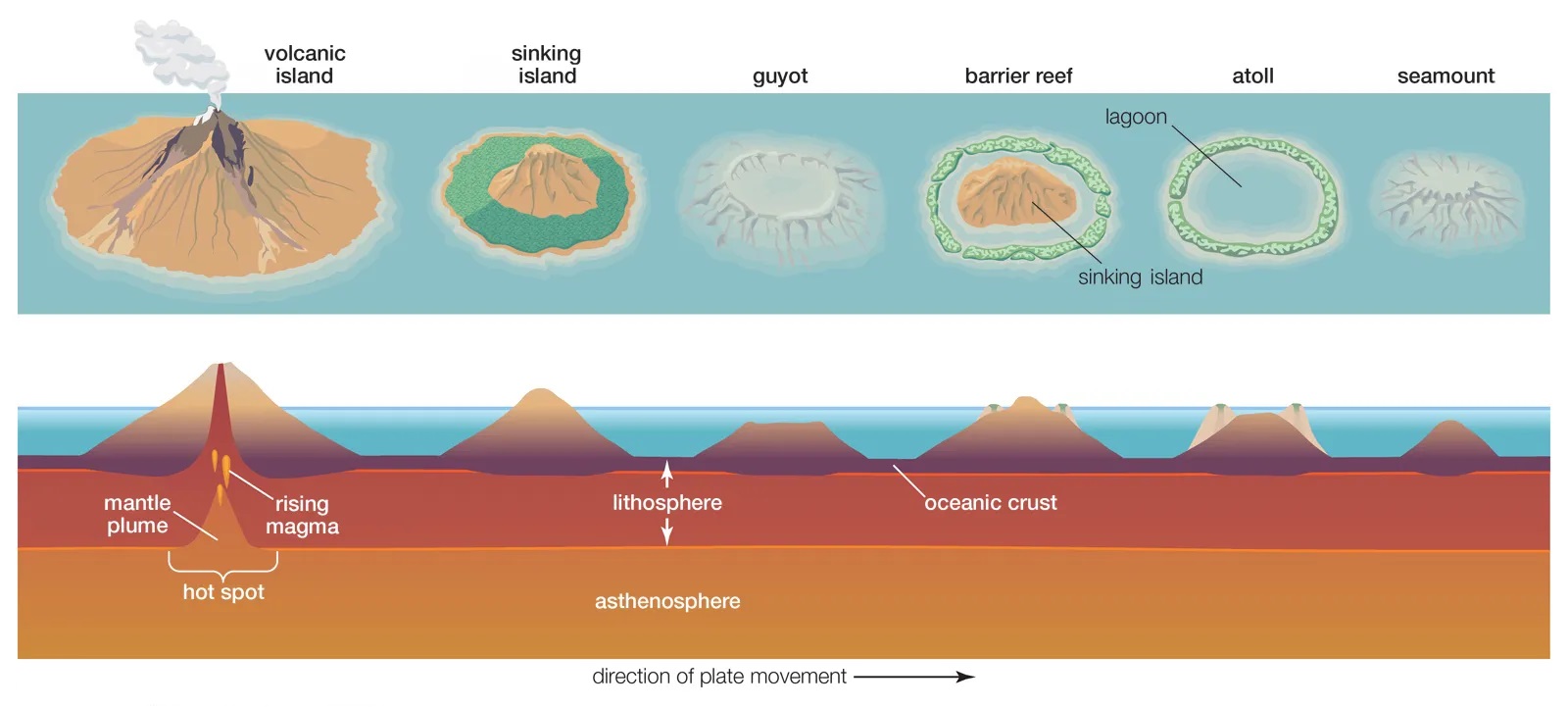
    • Seamounts are underwater mountains formed through volcanic activity.
    • They are recognised as hotspots for marine life.
    • Most seamounts are formed near mid-ocean ridges, intraplate hotspots, and oceanic island chains with volcanic and seismic activity called island arcs.
    • They can be active, extinct or dormant volcanoes.

    Importance of Seamounts

    • Seamounts provide information about the mantle’s composition and how tectonic plates evolve as they are formed when molten rock comes up from below the tectonic plates.
    • Oceanographers study seamounts to understand their influence on how water circulates and absorbs heat and carbon dioxide.
    • Seamounts are home to diverse biological communities as they can cause localised ocean upwelling, which brings nutrient-rich water from deep within the ocean to the surface.

    How were they mapped?

    • Surveyors map seamounts using either echo sounders or multibeam sonar on ships for topographic mapping or using satellite altimetry for gravity-field mapping.
    • The hi-res maps produced by multibeam sonar mapping are often incomplete, whereas the low-res maps produced by satellite altimetry have better coverage.


    Get an IAS/IPS ranker as your personal mentor for UPSC 2024 | Schedule your FREE session and get the Prelims prep Toolkit!

  • What is Ningaloo ‘Hybrid’ Solar Eclipse?

    ningaloo

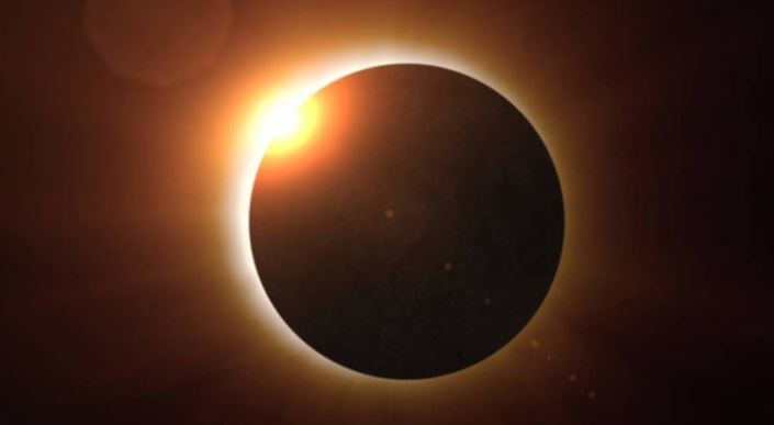
    A ‘hybrid’ solar eclipse called the Ningaloo Eclipse recently happened on April 20, 2023.

    Ningaloo ‘Hybrid’ Solar Eclipse

    • It was a rare astronomical event that occurred on April 20, 2023.
    • The Moon passed directly between the Sun and the Earth, casting a shadow on a narrow strip of land in Western Australia.
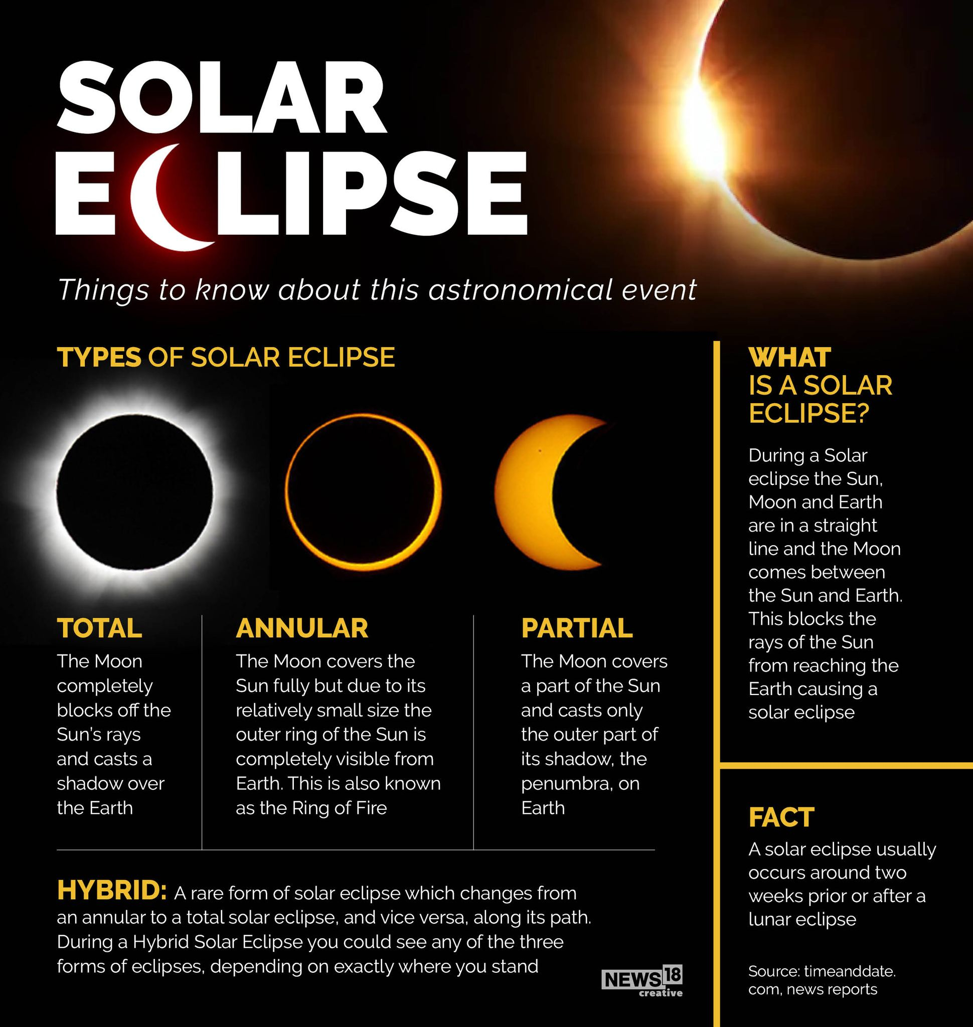
    • It was a “hybrid” eclipse, starting as an annular eclipse and transitioning into a total eclipse.
    • The path of the eclipse crossed over the Ningaloo Reef, a world heritage site in Western Australia.
    • It offered a unique opportunity to view the eclipse against the backdrop of the reef and the Indian Ocean.

    How rare are such events?

    • During a solar eclipse, the Moon passes between the Sun and Earth, casting a shadow on Earth’s surface.
    • However, solar eclipses do not occur every month because the Moon’s orbit is tilted by about 5 degrees relative to Earth’s orbit around the Sun.
    • Therefore, the Moon’s shadow usually misses Earth, but occasionally the alignment is just right for a solar eclipse to occur.
    • In the case of the Ningaloo Hybrid Solar Eclipse, the alignment was such that the Moon was at the right distance from Earth to create both an annular and a total eclipse as it moved across the Sun.
    • This type of eclipse is quite rare, occurring only about once every 400 years.

    Back2Basics:

    ningaloo

    Get an IAS/IPS ranker as your personal mentor for UPSC 2024 | Schedule your FREE session and get the Prelims prep Toolkit!

  • Africa’s splitting plates could give birth to a new Ocean: Study

    africa

    Central idea

    • Scientists predict a new ocean will be created as Africa splits into two separate parts connected to the East African Rift
    • This geological process will inevitably divide the continent resulting in new coastlines and sub-sea internet infrastructure but also will have significant repercussions

    What is Rifting?

    • The Earth’s lithosphere, comprising the crust and upper part of the mantle, is divided into tectonic plates that move in relation to each other at varying speeds.
    • Tectonic forces move the plates and can cause them to rupture, resulting in the formation of a rift and potentially leading to the creation of new plate boundaries.
    • Rifting refers to the geological process in which a single tectonic plate is split into two or more plates separated by divergent plate boundaries.
    • In the present day, the gradual separation of the Somali and Nubian tectonic plates is leading to the formation of a rift that could eventually lead to the creation of a new ocean basin.
    • The movement of tectonic plates is a fascinating geological phenomenon.

    Rifting in African Continent

    • The African continent is located on the African Plate, which is one of the Earth’s major tectonic plates.
    • The continent is characterized by a number of geological features, including rift valleys.

    Most profound feature: The East African Rift System

    • The East African Rift System is the most prominent example of rifting in Africa.
    • It stretches for over 6,000 kilometers from the Red Sea in the north to the Zambezi River in the south.
    • The rift system includes a series of interconnected rift valleys, volcanoes, and lakes.

    Causes of the East African Rift System

    • The rift system is caused by the movement of the African Plate away from the Arabian Plate and the Somalian Plate.
    • This movement creates tension in the Earth’s crust, causing it to pull apart and form a rift.

    Impact: Lakes Formed by Rifting

    • Over time, the rifting process has led to the formation of several large lakes in the region.
    • These lakes include Lake Victoria, Lake Tanganyika, and Lake Malawi.
    • They are believed to have formed as a result of the sinking of the land between the rift valleys.

    Future of Rifting in Africa

    • The rifting process is ongoing and may eventually lead to the splitting of the African continent into two or more separate land masses.
    • However, this process is expected to take millions of years and is not likely to have a significant impact on human populations in the near future.
    • The necessary evacuation of people and potential loss of lives will be an unfortunate cost of this natural phenomenon.
    • The emergence of new coastlines will unlock opportunities for economic growth
    • As the plates continue to split in the future, this phenomenon will result in the displacement of communities, settlements, and various flora and fauna.

    Conclusion

    • The movement of tectonic plates has significant implications for the continent’s future.
    • It is important to study and monitor these changes while remembering the power of the Earth’s natural forces and the impact they can have over time.

    Are you an IAS Worthy Aspirant? Get a reality check with the All India Smash UPSC Scholarship Test

    Get upto 100% Scholarship | 900 Registration till now | Only 100 Slots Left

  • Earth’s inner core rotating slower than surface: Study

    earth

    Earth’s inner core, a hot iron ball the size of Pluto, has stopped spinning faster than the planet’s surface and might now be rotating slower than it, research suggested.

    A quick recap of Earth’s Interior

    earth

    Structure of earth’s interior is fundamentally divided into three layers – crust, mantle and core.

    [A] Crust

    • It is the outermost solid part of the earth, normally about 8-40 kms thick.
    • It is brittle in nature.
    • Nearly 1% of the earth’s volume and 0.5% of earth’s mass are made of the crust.
    • The thickness of the crust under the oceanic and continental areas are different. Oceanic crust is thinner (about 5kms) as compared to the continental crust (about 30kms).
    • Major constituent elements of crust are Silica (Si) and Aluminium (Al) and thus, it is often termed as SIAL(Sometimes SIAL is used to refer Lithosphere, which is the region comprising the crust and uppermost solid mantle, also).
    • The mean density of the materials in the crust is 3g/cm3.
    • The discontinuity between the hydrosphere and crustis termed as the Conrad Discontinuity.

     [B] Mantle

    • The portion of the interior beyond the crust is called as the mantle.
    • The discontinuity between the crust and mantleis called as the Mohorovich Discontinuity or Moho discontinuity.
    • The mantle is about 2900kms in thickness.
    • Nearly 84% of the earth’s volume and 67% of the earth’s mass is occupied by the mantle.
    • The major constituent elements of the mantle are Silicon and Magnesium and hence it is also termed as SIMA.
    • The density of the layer is higher than the crust and varies from 3.3 – 5.4g/cm3.
    • The uppermost solid part of the mantle and the entire crust constitute the Lithosphere.
    • The asthenosphere (in between 80-200km) is a highly viscous, mechanically weak and ductile, deforming region of the upper mantle which lies just below the lithosphere.
    • The asthenosphere is the main source of magma and it is the layer over which the lithospheric plates/ continental plates move (plate tectonics).
    • The discontinuity between the upper mantle and the lower mantleis known as Repetti Discontinuity.
    • The portion of the mantle which is just below the lithosphere and asthenosphere, but above the core is called as Mesosphere.

    [C] Core

    • It is the innermost layer surrounding the earth’s centre.
    • The core is separated from the mantle by Guttenberg’s Discontinuity.
    • It is composed mainly of iron (Fe) and nickel (Ni) and hence it is also called as NIFE.
    • It constitutes nearly 15% of earth’s volume and 32.5% of earth’s mass.
    • It is the densest layer of the earth with its density ranges between 9.5-14.5g/cm3.
    • It spins independently because it floats in the liquid metal outer core. One cycle of the swing is about seven decades approximately.
    • It consists of two sub-layers: the inner core and the outer core.
    • The inner core is in solid state and the outer core is in the liquid state (or semi-liquid).
    • The discontinuity between the upper core and the lower core is called as Lehmann Discontinuity.
    • Barysphere is sometimes used to refer the core of the earth or sometimes the whole interior.

    What should one understand about the interior of the earth?

    • It is not possible to know about the earth’s interior by direct observations because of the huge size and the changing nature of its interior composition.
    • It is an almost impossible distance for the humans to reach till the centre of the earth (The earth’s radius is 6,370 km).
    • The rapid increase in temperature below the earth’s surface is mainly responsible for setting a limit to direct observations inside the earth.

    Sources of Information about the interior of the earth

    Direct Sources:

    1. Rocks from mining area
    2. Volcanic eruptions

    Indirect Sources

    1. By analyzing the rate of change of temperature and pressurefrom the surface towards the interior.
    2. Meteors, as they belong to the same type of materials earth is made of.
    3. Gravitation, which is greater near poles and less at the equator.
    4. Gravity anomaly, which is the change in gravity value according to the mass of material, gives us information about the materials in the earth’s interior.
    5. Magnetic sources.
    6. Seismic Waves: the shadow zones of body waves (Primary and secondary waves) give us information about the state of materials in the interior.

    What is the new study about?

    • Exactly how the inner core rotates has been a matter of debate between scientists— and the latest research is expected to prove controversial.
    • A new research has analyzed seismic waves from repeating earthquakes over the last six decades.
    • It shows that- the inner core started rotating slightly faster than the rest of the planet in the early 1970s, the study said.
    • But it had been slowing down before coming in sync with Earth’s rotation around 2009.

    What made the core spin slower?

    • So far there is little to indicate that what the inner core does has many effects on surface dwellers.
    • The researchers said this rotation timeline roughly lines up with changes in what is called the “length of day”— small variations in the exact time it takes Earth to rotate on its axis.
    • But the researchers said they believed there were physical links between all of Earth’s layers, from the inner core to the surface.


    Crack Prelims 2023! Talk to our Rankers

    (Click) FREE 1-to-1 on-call Mentorship by IAS-IPS officers | Discuss doubts, strategy, sources, and more

  • What is Winter Solstice?

    solstice

    Today, December 21, is Winter Solstice, the shortest day of the year in the Northern Hemisphere. In the Southern Hemisphere, conversely, it was Summer Solstice, the year’s longest day.

    What is Winter Solstice?

    • The winter solstice, also called the hibernal solstice, occurs when either of Earth’s poles reaches its maximum tilt away from the Sun.
    • This happens twice yearly, once in each hemisphere.

    What are Solstices?

    • Solstices occur because Earth’s axis of rotation is tilted about 23.4 degrees relative to Earth’s orbit around the sun.
    • This tilt drives our planet’s seasons, as the Northern and Southern Hemispheres get unequal amounts of sunlight over the course of a year.
    • From March to September, the Northern Hemisphere is tilted more toward the sun, driving its spring and summer.
    • From September to March, the Northern Hemisphere is tilted away, so it feels like autumn and winter.
    • The Southern Hemisphere’s seasons are reversed.
    • On two moments each year—what are called solstices—Earth’s axis is tilted most closely toward the sun.

    Impact on day-time

    • The hemisphere tilted most toward our home star sees its longest day, while the hemisphere tilted away from the sun sees its longest night.
    • During the Northern Hemisphere’s summer solstice—which always falls around June 21—the Southern Hemisphere gets its winter solstice.
    • Likewise, during the Northern Hemisphere’s winter solstice—which always falls around December 22—the Southern Hemisphere gets its summer solstice.

    Impact of the tilted axis

    • The Northern Hemisphere spends half the year tilted in the direction of the Sun, getting direct sunlight during long summer days.
    • During the other half of the year, it tilts away from the Sun, and the days are shorter.
    • Winter Solstice, December 21, is the day when the North Pole is most tilted away from the Sun.
    • The tilt is also responsible for the different seasons that we see on Earth.
    • The side facing the Sun experiences day, which changes to night as Earth continues to spin on its axis.

    Un-impacted regions

    • On the Equator, day and night are equal. The closer one moves towards the poles, the more extreme the variation.
    • During summer in either hemisphere, that pole is tilted towards the Sun and the polar region receives 24 hours of daylight for months.
    • Likewise, during winter, the region is in total darkness for months.

    Celebrations associated with the Winter Solstice

    • For centuries, this day has had a special place in several communities due to its astronomical significance and is celebrated in many ways across the world.
    • Jewish people call the Winter Solstice ‘Tekufat Tevet’, which marks the start of winter.
    • Ancient Egyptians celebrated the birth of Horus, the son of Isis (divine mother goddess) for 12 days during mid-winter.
    • In China, the day is celebrated by families coming together for a special meal.
    • In the Persian region, it is celebrated as Yalda or Shab-e-Yalda. The festival marks the last day of the Persian month of Azar and is seen as the victory of light over darkness.
    • Families celebrate Yalda late into the night with special foods such as ajeel nuts, pomegranates and watermelon, and recite works of the 14th-century Sufi poet Hafiz Shirazi.

    In Vedic tradition

    • In Vedic tradition, the northern movement of the Earth on the celestial sphere is implicitly acknowledged in the Surya Siddhanta.
    • It outlines the Uttarayana (the period between Makar Sankranti and Karka Sankranti). Hence, Winter Solstice is the first day of Uttarayana.


    Try this MCQ:

    Q. On 21st June, the Sun

    (a) Does not set below the horizon at the Arctic Circle

    (b) Does not set below the horizon at Antarctic Circle

    (c) Shines vertically overhead at noon on the Equator

    (d) Shines vertically overhead at the Tropic of Capricorn


    [wpdiscuz-feedback id=”g83sek2y9c” question=”Please leave a feedback on this” opened=”1″]Post your answers here.[/wpdiscuz-feedback]


    Click and get your FREE Copy of CURRENT AFFAIRS Micro Notes

    (Click) FREE 1-to-1 on-call Mentorship by IAS-IPS officers | Discuss doubts, strategy, sources, and more

  • Cyclone Mandous makes landfall in Tamil Nadu

    mandous

    Cyclone Mandous crossed the north Tamil Nadu coast with fierce winds and heavy downpour.

    Cyclone Mandous

    • ‘Mandous’ was a name submitted by WMO member United Arab Emirates and is pronounced as ‘Man-Dous.’
    • It means ‘treasure box’ in Arabic.

    What are Tropical Cyclones?

    • A tropical cyclone is an intense circular storm that originates over warm tropical oceans and is characterized by low atmospheric pressure, high winds, and heavy rain.
    • Cyclones are formed over slightly warm ocean waters. The temperature of the top layer of the sea, up to a depth of about 60 meters, need to be at least 28°C to support the formation of a cyclone.
    • This explains why the April-May and October-December periods are conducive for cyclones.
    • Then, the low level of air above the waters needs to have an ‘anticlockwise’ rotation (in the northern hemisphere; clockwise in the southern hemisphere).
    • During these periods, there is an ITCZ in the Bay of Bengal whose southern boundary experiences winds from west to east, while the northern boundary has winds flowing east to west.
    • Once formed, cyclones in this area usually move northwest. As it travels over the sea, the cyclone gathers more moist air from the warm sea which adds to its heft.

    Requirements for a Cyclone to form

    There are six main requirements for tropical cyclogenesis:

    • Sufficiently warm sea surface temperatures
    • Atmospheric instability
    • High humidity in the lower to middle levels of the troposphere
    • Enough Coriolis force to develop a low-pressure centre
    • A pre-existing low-level focus or disturbance
    • Low vertical wind shear

    How are the cyclones named?

    • In 2000, a group of nations called WMO/ESCAP (World Meteorological Organisation/United Nations Economic and Social Commission for Asia and the Pacific) decided to name cyclones.
    • It comprised Bangladesh, India, the Maldives, Myanmar, Oman, Pakistan, Sri Lanka and Thailand, decided to start naming cyclones in the region.
    • After each country sent in suggestions, the WMO/ESCAP Panel on Tropical Cyclones (PTC) finalized the list.
    • The WMO/ESCAP expanded to include five more countries in 2018 — Iran, Qatar, Saudi Arabia, United Arab Emirates and Yemen.

    Basics

    Cyclones

    • The atmospheric disturbances which involve a closed circulation of air around a low pressure at the center and high pressure at the periphery, rotating anti-clockwise in the northern hemisphere and clockwise in the southern hemisphere (due to the Coriolis force) are called “cyclones”.

    Cyclones are broadly classified into two types based on the latitudes of their origin-

    • Tropical cyclones
    • Temperate/Extra-tropical cyclones

    Tropical Cyclones

    • Tropical cyclones develop in the region between the tropics of Capricorn and Cancer. These are violent storms that originate over oceans in tropical areas and move on to the coastal regions bringing large-scale destruction caused by violent winds, very heavy rainfall and storm surges. These cyclones are one of the most devastating natural calamities.
    • Tropical cyclones mostly move along with the direction of trade winds, so they travel from east to west and make landfall on the eastern coasts of the continents.
    • Tropical cyclones are known by different names depending on the regions of the world. They are known as Hurricanes in the Atlantic, Typhoons in the Western Pacific and South China Sea, Willy-willies in Western Australia and Cyclones in the Indian Ocean.

    Temperate Cyclones/Extra-Tropical Cyclones

    • It occurs between 30°-60° latitude in both hemispheres (in between the Tropic of Cancer and the Arctic circle in the northern hemisphere and in between the Tropic of Capricorn and the Antarctic Circle in the southern hemisphere).
    • These cyclones move with the westerlies and are therefore oriented from west to east.

    Click and get your FREE Copy of CURRENT AFFAIRS Micro Notes

    (Click) FREE 1-to-1 on-call Mentorship by IAS-IPS officers | Discuss doubts, strategy, sources, and more