💥Join UPSC 2027,2028 Mentorship (July Batch) + XFactor Notes & Microthemes PDF

Subject: Geographical Features

  • Earthquake in Afghanistan

    Recently a powerful earthquake of magnitude 5.9 on the Richter scale struck a remote town in Afghanistan, killing over a thousand and injuring many more.

    How do earthquakes happen?

    • According to the theory of plate tectonics, the Earth’s crust and upper mantle are made of large rigid plates that can move relative to one another.
    • Slip on faults near the plate boundaries can result in earthquakes.
    • The point inside the Earth where the earthquake rupture starts is called the focus or hypocentre.
    • The point directly above it on the surface of the Earth is the epicentre.

    What are Seismic Waves?

    • Any elastic material when subjected to stress, stretches in a proportional way, until the elastic limit is reached.
    • When the elastic limit is crossed, it breaks.
    • Similarly, the Earth also has an elastic limit and when the stress is higher than this limit, it breaks.
    • Then there is a generation of heat, and energy is released. Since the material is elastic, the energy is released in the form of elastic waves.
    • These propagate to a distance determined by the extent of the impact. These are known as seismic waves.

    Why Earthquake in Afghanistan?

    • Afghanistan is earthquake-prone because it’s located in the mountainous Hindu Kush region, which is part of the Alpide belt — the second most seismically active region in the world after the Pacific Ring of Fire.
    • The Alpide belt runs about 15,000 kilometers, from the southern part of Eurasia through the Himalayas and into the Atlantic.
    • Along with the Hindu Kush, it includes a number of mountain ranges, such as the Alps, Atlas Mountains and the Caucasus Mountains.
    • Additionally, the Earth’s crust is especially lively in Afghanistan because it is where the Arabian, Indian and Eurasian tectonic plates meet.
    • The boundary between the Indian and Eurasian plates exists near Afghanistan’s border with Pakistan.

    How are earthquakes measured?

    • Earthquakes are measured by seismographic networks, which are made of seismic stations, each of which measures the shaking of the ground beneath it.
    • In India, the National Seismological Network does this work.
    • It has a history of about 120 years and its sensors can now detect an earthquake within five to ten minutes.

    Issues with Earthquake measurement

    • Everywhere, the wave parameters are measured, not the total energy released.
    • There is a direct relationship between the quantum of energy released and the wave amplitude.
    • The amplitude of the wave is a function of the time period of the wave.
    • It is possible to convert the measured wave amplitude into the energy released for that earthquake.
    • This is what seismologists call the magnitude of the earthquake.

    What is the Richter magnitude scale?

    • This is a measure of the magnitude of an earthquake and was first defined by Charles F. Richter of the California Institute of Technology, U.S., in 1935.
    • The magnitude of an earthquake is the logarithm of the amplitude of the waves measured by the seismographs.
    • Richter scale magnitudes are expressed as a whole number and a decimal part, for example 6.3 or 5.2.
    • Since it is a logarithmic scale, an increase of the whole number by one unit signifies a tenfold increase in the amplitude of the wave and a 31-times increase of the energy released.

    How are zones designated?

    • Based on seismicity, intensity of earthquakes experienced, and geological and tectonic qualities of a region, countries are divided into several zones.
    • In India, for example, there are four zones, designated Zone II-Zone V. Among these, Zone V is the most hazardous and Zone II the least hazardous.

    Can we predict Earthquakes?

    • Since parameters of the earthquake are unknown, it is near impossible to predict an earthquake.
    • The problem with earthquakes is that they are heavily dependent on the material property, which varies from place to place.
    • If there are elastic waves propagating through a material, there are two kinds of waves — the primary wave which reaches first, and the second one called the secondary wave, which is more destructive.
    • If it is known that the amount of energy released is extremely high, trains and power grids can be shut down and the damage minimised.
    • This has worked in some locations, but not on a large commercial basis.

    Successful attempts made so far

    • The most successful early warning systems are in Japan.
    • They have several hundreds of thousands recording devices.
    • Responses are sent to a central point where they estimate whether it is large enough to form a tsunami or some other hazard, and precautionary steps are taken.


    UPSC 2023 countdown has begun! Get your personal guidance plan now! (Click here)

  • What is Onset of Monsoon?

    The monsoon is slated to make its earliest arrival in 13 years over Kerala, informs the India Meteorological Department (IMD).

    What does the “Onset of Monsoon” mean?

    • The onset of the monsoon over Kerala marks the beginning of the four-month, June to September southwest monsoon season over India.
    • It brings more than 70 per cent of the country’s annual rainfall.
    • It marks a significant transition in the large-scale atmospheric and ocean circulations in the Indo-Pacific region.
    • The IMD announces it only after certain newly defined and measurable parameters, adopted in 2016, are met.
    • The onset is a significant day in India’s economic calendar.

    How does IMD predict the monsoon?

    • Broadly, the IMD checks for the consistency of rainfall over a defined geography, its intensity, and wind speed:
    1. Rainfall: The IMD declares the onset of the monsoon if at least 60% of 14 designated meteorological stations in Kerala and Lakshadweep record at least 2.5 mm of rain for two consecutive days at any time after May 10.
    2. Wind field: The depth of westerlies should be upto 600 hectopascal (1 hPa is equal to 1 millibar of pressure) in the area bound by the equator to 10ºN latitude, and from longitude 55ºE to 80ºE. The zonal wind speed over the area bound by 5-10ºN latitude and 70-80ºE longitude should be of the order of 15-20 knots (28-37 kph) at 925 hPa.
    3. Heat: The INSAT-derived Outgoing Longwave Radiation (OLR) value (a measure of the energy emitted to space by the Earth’s surface, oceans, and atmosphere) should be below 200 watt per sq m (wm2) in the box confined by 5-10ºN latitude and 70-75ºE latitude.
    • The onset is not officially declared until the prescribed conditions (above) are met.

    Factors considered by IMD

    • The IMD uses a specialised model that forecasts the arrival dates within a four-day window.
    • It uses six predictors:
    1. Minimum temperatures over northwest India
    2. Pre-monsoon rainfall peak over south Peninsula
    3. Outgoing long-wave radiation (OLR) over the South China Sea
    4. Lower tropospheric zonal wind over the southeast Indian Ocean
    5. Upper tropospheric zonal wind over the east equatorial Indian Ocean, and
    6. OLR over the southwest Pacific region

    Where is the early arrival noticed?

    • The monsoon’s arrival over India is marked by rain over south Andaman Sea, which then advances north-westwards across the Bay of Bengal.
    • In general, the Andaman and Nicobar Islands start receiving monsoon rainfall between May 15 and May 20 every year.
    • And it usually starts raining along the Kerala coast in the last week of May.

    Does an early onset foretell a good monsoon?

    • No, it does not — just as a delay does not foretell a poor monsoon.
    • The onset is just an event that happens during the progress of the monsoon over the Indian subcontinent.
    • A delay of a few days, or perhaps the monsoon arriving a few days early, has no bearing on the quality or amount of rainfall, or its regional distribution across the country.

    Back2Basics: Long Period Average (LPA)

    • The IMD predicts a “normal”, “below normal”, or “above normal” monsoon in relation to a benchmark “long period average” (LPA).
    • The LPA of rainfall is the rainfall recorded over a particular region for a given interval (like month or season) average over a long period like 30 years, 50 years, etc.
    • LPA refers to the average rainfall recorded from June to September for the entire country, the amount of rain that falls every year varies from region to region and from month to month.
    • The IMD’s prediction of a normal monsoon is based on the LPA of the 1971-2020 period, during which India received 87 cm of rain for the entire country on average.
    • It has in the past calculated the LPA at 88 cm for the 1961-2010 period, and at 89 cm for the period 1951-2000.

    Why LPA is needed?

    • The IMD records rainfall data at more than 2,400 locations and 3,500 rain-gauge stations.
    • Because annual rainfall can vary greatly not just from region to region and from month to month, but also from year to year within a particular region or month.
    • An LPA is needed to smooth out trends so that a reasonably accurate prediction can be made.
    • A 50-year LPA covers for large variations in either direction caused by freak years of unusually high or low rainfall, as well as for the periodic drought years.
    • It also takes into account the increasingly common extreme weather events caused by climate change.

    Range of normal rainfall

    The IMD maintains five rainfall distribution categories on an all-India scale. These are:

    1. Normal or near normal, when the percentage departure of actual rainfall is +/-10% of LPA, that is, between 96-104% of LPA;
    2. Below normal, when departure of actual rainfall is less than 10% of LPA, that is 90-96% of LPA;
    3. Above normal, when actual rainfall is 104-110% of LPA;
    4. Deficient, when departure of actual rainfall is less than 90% of LPA; and
    5. Excess, when the departure of actual rainfall is more than 110% of LPA.

    Also read

    Various terms related to Indian Monsoon


    UPSC 2023 countdown has begun! Get your personal guidance plan now! (Click here)

  • What is the ‘Long Period Average’, IMD’s benchmark for monsoon prediction?

    India is likely to receive a normal monsoon for the fourth consecutive year, the India Meteorological Department (IMD) said in its first Long Range Forecast (LRF) for this year.

    What is Long Period Average (LPA)?

    • The IMD predicts a “normal”, “below normal”, or “above normal” monsoon in relation to a benchmark “long period average” (LPA).
    • The LPA of rainfall is the rainfall recorded over a particular region for a given interval (like month or season) average over a long period like 30 years, 50 years, etc.
    • LPA refers to the average rainfall recorded from June to September for the entire country, the amount of rain that falls every year varies from region to region and from month to month.
    • The IMD’s prediction of a normal monsoon is based on the LPA of the 1971-2020 period, during which India received 87 cm of rain for the entire country on average.
    • It has in the past calculated the LPA at 88 cm for the 1961-2010 period, and at 89 cm for the period 1951-2000.

    Why LPA is needed?

    • The IMD records rainfall data at more than 2,400 locations and 3,500 rain-gauge stations.
    • Because annual rainfall can vary greatly not just from region to region and from month to month, but also from year to year within a particular region or month.
    • An LPA is needed to smooth out trends so that a reasonably accurate prediction can be made.
    • A 50-year LPA covers for large variations in either direction caused by freak years of unusually high or low rainfall, as well as for the periodic drought years.
    • It also takes into account the increasingly common extreme weather events caused by climate change.

    Range of normal rainfall

    The IMD maintains five rainfall distribution categories on an all-India scale. These are:

    1. Normal or near normal, when the percentage departure of actual rainfall is +/-10% of LPA, that is, between 96-104% of LPA;
    2. Below normal, when departure of actual rainfall is less than 10% of LPA, that is 90-96% of LPA;
    3. Above normal, when actual rainfall is 104-110% of LPA;
    4. Deficient, when departure of actual rainfall is less than 90% of LPA; and
    5. Excess, when the departure of actual rainfall is more than 110% of LPA.

    Also read:

    Various terms related to Indian Monsoon


    UPSC 2022 countdown has begun! Get your personal guidance plan now! (Click here)

  • [pib] International Monsoons Project Office (IMPO)

    Union Minister of Science & Technology has launched the International Monsoons Project Office (IMPO).

    International Monsoons Project Office (IMPO)

    • IMPO will be hosted at the Indian Institute of Tropical Meteorology (IITM), Pune, an institution under the Ministry of Earth Sciences, Govt of India, initially for five years.
    • Setting up the IMPO reiterates the importance of monsoons for the national economy.
    • It would encompass activities and connections related to international monsoon research that would be identified and fostered under the leadership of the World Climate Research Programme.
    • Both the World Climate Research Programme and World Weather Research Programme are international programmes coordinated by the United Nations World Meteorological Organisation (WMO).

    Significance of IMPO

    • Setting up the IMPO in India would mean expanding an integrated scientific approach to solve the seasonal variability of monsoons, enhancing the prediction skill of monsoons and cyclones.
    • It would promote knowledge sharing and capacity building in areas of monsoon research crucial for agriculture, water resources and disaster management, hydropower and climate-sensitive socio-economic sectors.
    • It is a step towards making India a global hub for monsoon research and coordination in a seamless manner for addressing common and region-specific aspects of the monsoons around the world.

    UPSC 2022 countdown has begun! Get your personal guidance plan now! (Click here)


    Back2Basics:

    Various terms related to Indian Monsoon

  • Places in news: Erra Matti Dibbalu

    Citizens join hands to preserve the geological marvel of Erra Matti Dibbalu in Visakhapatnam.

    What is Erra Matti Dibbalu?

    • Located between Visakhapatnam and Bheemunipatnam, the Erra Matti Dibbalu are rare red sand dunes that are a reminder of the million years of geological processes.
    • Its towering red sand dunes with patches of greenery is like a meandering maze.
    • The width of the dunes, which runs for five kilometres along the coast, varies from 200 metres to two kilometres.
    • It is listed among the 34 notified National Geological Heritage Monument Sites of India by the Geological Survey of India.

    (Don’t they resemble to Ravines of Chambal?)

    Its formation

    • Studies indicate that the area was tectonically active between 2.5 million years and 11,000 years ago.
    • The sediments are mainly derived from the Khondalite rocks from the hinterland of the Eastern Ghats.
    • Geologically these red sand dune sediments particularly hold significance.
    • They are the result of the combined effect of numerous factors including global climatic changes, sea-level variations, monsoonal variability and as a result serves as valuable paleo-environment indicators.


    UPSC 2022 countdown has begun! Get your personal guidance plan now! (Click here)

  • What is the Pacific ‘Ring of Fire’?

    The Hunga Tonga-Hunga Ha’apai volcano which massively erupted lies along the Pacific ‘Ring of fire’, and is just over 60 kilometers from the island nation of Tonga.

    What is the Pacific ‘Ring of Fire’?

    • The Pacific ‘Ring of Fire’ or Pacific rim, or the Circum-Pacific Belt, is an area along the Pacific Ocean that is characterized by active volcanoes and frequent earthquakes.
    • Volcanic arcs and oceanic trenches partly encircling the Pacific Basin form the so-called Ring of Fire.
    • It is home to about 75 per cent of the world’s volcanoes – more than 450 volcanoes.
    • Also, about 90 per cent of the world’s earthquakes occur here.

    Its spread

    • Its length is over 40,000 kilometres and traces from New Zealand clockwise in an almost circular arc covering Tonga, Kermadec Islands, Indonesia.
    • It is moving up to the Philippines, Japan, and stretching eastward to the Aleutian Islands, then southward along the western coast of North America and South America.

    Seismic activity of the region

    • The area is along several tectonic plates including the Pacific plate, Philippine Plate, Juan de Fuca plate, Cocos plate, Nazca plate, and North American plate.
    • The movement of these plates or tectonic activity makes the area witness abundant earthquakes and tsunamis every year.
    • Along much of the Ring, tectonic plates move towards each other creating subduction zones.
    • One plate gets pushed down or is subducted by the other plate.
    • This is a very slow process – a movement of just one or two inches per year.
    • As this subduction happens, rocks melt, become magma and move to Earth’s surface and cause volcanic activity.

    What has happened in recent eruption in Tonga?

    • In the case of Tonga, the Pacific Plate was pushed down below the Indo-Australian Plate and Tonga plate, causing the molten rock to rise above and form the chain of volcanoes.
    • Subduction zones are also where most of the violent earthquakes on the planet occur.
    • The December 26, 2004 earthquake occurred along the subduction zone where the Indian Plate was subducted beneath the Burma plate.


    UPSC 2022 countdown has begun! Get your personal guidance plan now! (Click here)
  • Undersea Volcanic Eruption in Hunga Islands, Tonga

    A distant undersea volcano has erupted in spectacular fashion near the Pacific nation of Tonga sending large tsunami waves reaching the shore.

    Hunga Volcano

    • The Hunga-Tonga-Hunga-Ha’apai volcano has erupted regularly over the past few decades.
    • It consists of two small uninhabited islands, Hunga-Ha’apai and Hunga-Tonga, poking about 100m above sea level 65km north of Tonga’s capital Nuku’alofa.
    • But hiding below the waves is a massive volcano, around 1800m high and 20 kilometres wide.
    • During events in 2009 and 2014/15 hot jets of magma and steam exploded through the waves. But these eruptions were small, dwarfed in scale by the January 2022 events.
    • Researchers suggest this is one of the massive explosions the volcano is capable of producing roughly every thousand years.

    Impact of the eruption

    • The ash plume is already about 20km high.
    • Most remarkably, it spread out almost concentrically over a distance of about 130km from the volcano, creating a plume with a 260km diameter, before it was distorted by the wind.
    • The eruption also produced a tsunami throughout Tonga and neighbouring Fiji and Samoa.
    • Shock waves traversed many thousands of kilometres, were seen from space, and recorded in New Zealand some 2000km away.
    • All these signs suggest the large Hunga caldera has awoken.

    Why is it so explosive even after being underwater?

    Answer: Fuel-coolant interaction

    • If magma rises into sea water slowly, even at temperatures of about 1200 degrees Celsius, a thin film of steam forms between the magma and water.
    • This provides a layer of insulation to allow the outer surface of the magma to cool.
    • But this process doesn’t work when magma is blasted out of the ground full of volcanic gas.
    • When magma enters the water rapidly, any steam layers are quickly disrupted, bringing hot magma in direct contact with cold water.
    • Volcano researchers call this ‘fuel-coolant interaction’ and it is akin to weapons-grade chemical explosions.

    A chain reaction

    • Extremely violent blasts tear the magma apart.
    • A chain reaction begins, with new magma fragments exposing fresh hot interior surfaces to water, and the explosions repeat, ultimately jetting out volcanic particles and causing blasts with supersonic speeds.

    How has it emerged out to be so big?

    • The caldera is a crater-like depression around 5km across.
    • Small eruptions (such as in 2009 and 2014/15) occur mainly at the edge of the caldera, but very big ones come from the caldera itself.
    • These big eruptions are so large the top of the erupting magma collapses inward, deepening the caldera.
    • Looking at the chemistry of past eruptions, we now think the small eruptions represent the magma system slowly recharging itself to prepare for a big event.

    What next?

    • This latest eruption has stepped up the scale in terms of violence.
    • Researchers are still in the middle of this major eruptive sequence and many aspects remain unclear, partly because the island is currently obscured by ash clouds.


    UPSC 2022 countdown has begun! Get your personal guidance plan now! (Click here)
  • Places in news: Darvaza Gas Crater

    Turkmenistan President has ordered experts to find a way to extinguish a fire in a huge natural gas crater, the Darvaza gas crater also known as the ‘Gateway to Hell’.

    Darvaza Gas Crater

    • Located in the Karakum desert, 260 kilometres away from Turkmenistan’s capital, Ashgabat, the crater has been burning for the last 50 years.
    • The crater is 69 metres wide and 30 metres deep.
    • While the details of the origin of the crater are contested but it has been said that the crater was created in 1971 during a Soviet drilling operation.
    • In 1971, Soviet geologists were drilling for oil in the Karakum desert when they hit a pocket of natural gas by mistake, which caused the earth to collapse and ended up forming three huge sinkholes.

    Why is it flamed?

    • This pocket of natural gas contained methane, hence to stop that methane from leaking into the atmosphere, the scientists lit it with fire, assuming the gas present in the pit would burn out within a few weeks.
    • The scientists seemed to have misjudged the amount of gas present in the pit, because the crater has been on fire for five decades now.

    A popular tourist attraction

    • The crater has become a significant tourist attraction in Turkmenistan.
    • In 2018, the country’s president officially renamed it as the “Shining of Karakum”.

    Why did Turkmenistan order to extinguish it?

    • Calling it a human-made crater, it has negative effects on both environment and the health of the people living nearby.
    • It also ends up losing valuable natural resources for which could fetch significant profits.

    How harmful are methane leaks?

    • Methane is the primary contributor to the formation of ground-level ozone, a hazardous air pollutant and greenhouse gas, exposure to which causes 1 million premature deaths every year.
    • Methane is also a powerful greenhouse gas. Over a 20-year period, it is 80 times more potent at warming than carbon dioxide.

    Back2Basics: TAPI Gas Pipeline

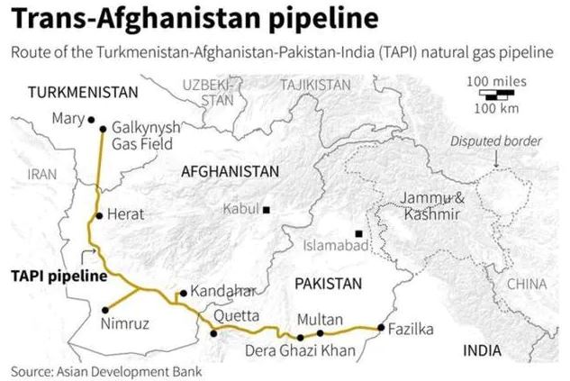
    • The Turkmenistan–Afghanistan–Pakistan–India (TAPI) Pipeline is a natural gas pipeline being developed with the participation of the Asian Development Bank.
    • It will be a 1,814km trans-country natural gas pipeline running across four countries.
    • It will transport natural gas from the Galkynysh Gas Field in Turkmenistan through Afghanistan into Pakistan and then to India.
    • The plan for the TAPI project was originally conceived in the 1990s to generate revenue from Turkmenistan’s gas reserves by exporting natural gas via Afghanistan to Pakistan and India.
    • Construction on the project started in Turkmenistan on 13 December 2015, work on the Afghan section began in February 2018, and work on the Pakistani section was planned to commence in December 2018.
    • Presently, the construction work has been stalled due to terror activities of Taliban in Afghanistan since few years.


    UPSC 2022 countdown has begun! Get your personal guidance plan now! (Click here)

  • India’s first open Rock Museum in Hyderabad

    The Ministry of Science & Technology has inaugurated India’s first open rock museum displaying different types of rocks gathered from different States of ages ranging from 3.3 billion years to around 55 million years.

    Rock System in India

    Based on this complex and varied geological history, the Geological Survey of India has classified rock systems of the country into 4 major divisions:

    1. Archaean Rock System
    2. Dravidian Rock System
    3. Purana Rock System
    4. Aryan Rock System

    [I] Archaean Rock System:

    The Archaean group of rocks consists of two systems-(a) Achaean granites and gneisses, and (b) Dharwarian sedimentary:

    Archaean Gneisses and Schists (pre-2500 million years)

    • The Archean System contains the first formed rocks of the earth.
    • The rocks are primarily gneisses and granites, having no marks of fossils.
    • They often underlie the strata formed subsequently and the system is generally known as the basement complex or fundamental gneisses.
    • The Archaean rocks cover two-thirds of peninsular India. They also occur in the roots of the mountain peaks all along the Greater Himalayas, trans-Himalayan ranges of Zaskar, Ladakh and Karakoram.

    Dharwar System (2500-1800 million years ago)

    • The weathering of the Archaean rocks yielded the earliest sediments and formed the oldest sedimentary strata, the Dharwar system.
    • These are found today in metamorphic forms and do not contain fossils.
    • These rocks occur in scattered patches in parts of Karnataka, Tamil Nadu, central and eastern parts of Chotanagpur plateau, Meghalaya plateau, Aravalis, Himalayan region etc

    Mineral contents:

    • They contain gneisses (which range from granite to gabbro) and schists (crystalline rocks such as mica, talc etc.).
    • These rocks have metallic and non-metallic minerals like copper, tin, graphite, lead, zinc, etc.

    [II] Dravidian Rock System:

    • This is also known as carboniferous rock system and formed during the Paleozoic era, i.e., from 600- 300 million years ago.
    • They are not much abundant in India.
    • They have plentiful fossils and beginning of coal formation can be seen in this period. The quality of carboniferous coal is high.
    • They are found in extra- Peninsular regions of the Himalayas and the Gangetic plains.

    Mineral content

    • This type of rock system comprises of limestones, shale and quartzite and Mount Everest is formed of upper Carboniferous limestones.
    • Most of the coal is not of the Carboniferous period, which is found in India.
    • The meaning of Carboniferous in geology is coal-bearing.

    [III] Purana Rock System:

    The Purana rock system has two divisions: Cuddapah system and Vindhyan system. The word ‘Purana’ was used in place of a Proterozoic era in India.

    Cuddapah Rock system:

    • They are observed in Cuddapah districts of Andhra Pradesh.
    • The non-fossiliferous clay, slates, sandstones and limestones were accumulated in the depression between two-fold mountains which is known as synclinal basins.
    • They also have a large accumulation of building purpose cement grade limestones and quartzites.
    • This type of rock contains ore of iron, cobalt, nickel, manganese etc.

    Vindhya Rock System:

    • This type of rock system is also ancient or old sedimentary rocks which are superimposed on the Archaean rock base and derived its name from Vindhya mountains.
    • The recognition of fossils is negligible, only traces of few animal and plant life were found.
    • This rock system has diamond-bearing regions from which Golconda and Panna diamond mined.

    [IV] Aryan Rock System

    The Aryan rock system in India has the following four subsystems:

    1. Gondwana rock system
    2. Jurassic Rock System
    3. Cretaceous system/ Deccan Trap
    4. Tertiary rock system

    (1) Gondwana Rock System:

    • These are found mainly in Raniganj, Jharia regions of Jharkhand, Damodar valley, Pench valley in Chhattisgarh and Madhya Pradesh.
    • They are called so after the name of Gondwana tribe (indigenous people especially residing in Telangana and Andhra Pradesh region).
    • In this type of rock system, you found metallic minerals like iron, manganese, uranium etc. other than coal.
    • They have low carbon content as it is much younger than Carboniferous coal. These rocks have nearly 98% of India’s coal reserve.

    (2) Jurassic Rock System

    • During the latter part of Jurrasic when sea level rises as compared to land and shoreline moves towards ground or land which result in a flood. In geology, this phenomenon is called marine transgression.
    • This gives rise to a thick series of shallow-water deposits kin Rajasthan and Kutch. Between the Guntur and Rajamundry, another transgression in the east coast of Peninsula.
    • In Kuchchh, coral limestone, shales and conglomerates are found.

    (3) Deccan traps

    • These are formed by the flow of magma over the solidified rock system in layers.
    • Deccan trap gets rise due to volcanic outburst over a major area of Peninsular India from the end of Cretaceous till the beginning of Eocene.
    • The meaning of trap is “stair” or “step” in Swedish and called due to deposition of the volcanic outburst which has a flat top and steep sides.
    • It is mainly found in parts of Kuchchh, Saurashtra, Maharashtra, the Malwa plateau and Northern Karnataka and presently cover near 5 lakh sq. Km.
    • Regur, which is black soil, is formed due to the weathering of these rocks for a long time.

    (4) Tertiary rock system

    • The formation of this type of rock system occurs from 60 to 7 million years ago.
    • It is the most noteworthy period in India’s geological history as the Himalayas were born and recent form came in this period.

    Also read:

    The Geological Structure of India


    UPSC 2022 countdown has begun! Get your personal guidance plan now! (Click here)

  • Western Disturbances to bring rain in New Delhi

    Under the influence of two consecutive western disturbances, New Delhi is in for a wet spell.

    Western Disturbances

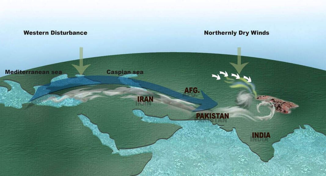
    • A western disturbance is an extratropical storm originating in the Mediterranean region that brings sudden winter rain to the northwestern parts of the Indian subcontinent.
    • It is a non-monsoonal precipitation pattern driven by the westerlies.
    • The moisture in these storms usually originates over the Mediterranean Sea, the Caspian Sea and the Black Sea.
    • Extratropical storms are global phenomena with moisture usually carried in the upper atmosphere, unlike their tropical counterparts where the moisture is carried in the lower atmosphere.
    • In the case of the Indian subcontinent, moisture is sometimes shed as rain when the storm system encounters the Himalayas.
    • Western disturbances are more frequent and strong in the winter season.

    Impact: Winter Rainfall and Extreme Cold

    • Western disturbances, specifically the ones in winter, bring moderate to heavy rain in low-lying areas and heavy snow to mountainous areas of the Indian Subcontinent.
    • They are the cause of most winter and pre-monsoon season rainfall across northwest India.
    • An average of four to five western disturbances forms during the winter season.

    Its significance

    • Precipitation during the winter season has great importance in agriculture, particularly for the rabi crops.
    • Wheat among them is one of the most important crops, which helps to meet India’s food security.

    Try this PYQ:

    Q. Consider the following statements:

    1. The winds which blow between 30°N and 60°S latitudes throughout the year are known as westerlies.
    2. The moist air masses that cause winter rains in the North-Western region of India are part of westerlies.

    Which of the statements given above is/are correct?

    (a) Only 1

    (b) Only 2

    (c) Both 1 and 2

    (d) Neither 1 nor 2


    [wpdiscuz-feedback id=”9y7ae6mirv” question=”Please leave a feedback on this” opened=”1″]Post your answers here.[/wpdiscuz-feedback]


    UPSC 2022 countdown has begun! Get your personal guidance plan now! (Click here)