💥Join UPSC 2027,2028 Mentorship (July Batch) + XFactor Notes & Microthemes PDF

Subject: Conservation & Mitigation

1. Conservation Progs.
2. Worldwide initiatives
3. Mitigation Strategies
4. Conventions and Protocols

  • [8th July 2024] The Hindu Op-ed: A law around low-carbon climate-resilient development


    PYQ Relevance:

    Mains: 

    Q) Climate change’ is a global problem. How India will be affected by climate change? How Himalayan and coastal states of India will be affected by climate change? (UPSC CSE 2017) 

    Q) ‘Clean energy is the order of the day.’ Describe briefly India’s changing policy towards climate change in various international fora in the context of geopolitics. (UPSC CSE 2022) 

    Note4Students: 

    Prelims: Supreme court judgements related to climate change impact,

    Mains:  Role of state and local Government to address the impact of climate change, 

    Mentor comment: Climate change poses grave threats to human rights, including the rights to life, health, food, water, housing, and an adequate standard of living. Extreme weather events, sea-level rise, and environmental degradation disproportionately impact vulnerable populations. Governments have a legal obligation to curb climate change, and corporations must respect human rights by reducing emissions and adapting to climate impacts. Addressing climate change is crucial to upholding human rights and ensuring a sustainable future for all.

    Let’s learn!

    __ __

    Why in the news? 

    In a landmark judgment, the Supreme Court of India recently recognized a right to be “free from the adverse impacts of climate change” in “M.K. Ranjitsinh and Others vs Union of India”, deriving it from the right to life and the right to equality.

    Law to inform development choices 

    • Integrating Climate Objectives into Development: Ensure that low-carbon and climate-resilient futures are prioritized in routine decision-making at all levels of development. Embed climate objectives in the legal framework to guide sustainable development choices.
    • Grounding Climate Action in Social Justice: Design laws to protect vulnerable populations disproportionately affected by climate change. Ensure the energy transition is just and equitable, advancing social justice and inclusive development.
    • Adopting a Comprehensive and Flexible Approach: Move beyond top-down emission targets to address broader developmental choices and their long-term impacts. Establish well-defined legal procedures that promote continuous consideration of low-carbon and climate-resilient futures.
    • Building a Robust Institutional Framework: Create an institutional structure to strategize, prioritize, troubleshoot, and evaluate climate policies. Enhance governance capacity to ensure credible and accountable climate action across all levels of government.
    • Tailoring Framework Climate Laws to the Indian Context: Adapt elements of global framework climate laws to suit India’s specific needs, focusing on maximising development per unit of carbon emitted. Emphasize climate resilience and social equity, ensuring development progresses in a low-carbon direction while building resilience to pervasive climate impacts.

     Need for a Low-Carbon Development Body

    • Rigorous Policy Analysis and Knowledge Generation: Establish a knowledge body in government to rigorously analyze policy options and their potential futures. Enable informed decision-making through a comprehensive understanding of low-carbon development and resilience strategies.
    • Expertise and Technical Guidance: Create an independent ‘low-carbon development commission’ staffed with experts and technical personnel. Provide national and state governments with practical guidance on achieving low-carbon growth and resilience.
    • Deliberative Decision-Making and Stakeholder Consultation: Facilitate a platform for deliberative decision-making involving multiple stakeholders. Systematically consult vulnerable communities and those adversely affected by technological changes to ensure their concerns are heard and integrated, leading to more sustainable and inclusive policy outcomes.
    • Strategic Direction and Whole-of-Government Coordination: Form a high-level strategic body, or ‘climate cabinet,’ comprising key Ministers and representation from State Chief Ministers to drive climate strategy across government. Address the challenge of siloed decision-making by promoting a whole-of-government approach with dedicated coordination mechanisms.
    • Enhanced Governance and Legal Empowerment: Complement the role of the Ministry of Environment, Forest, and Climate Change with higher-level coordination bodies. Reinforce existing structures like the Executive Committee on Climate Change with clearly defined legal powers and duties to ensure effective implementation and accountability in climate governance.

    Role of State and Local Governments in Climate Law

    • Engagement with Federal Structure: Recognize the importance of India’s federal structure in climate governance. Acknowledge that crucial areas for emission reduction and resilience improvement, such as electricity, agriculture, water, health, and soil, are managed by State and local governments.
    • First Responders to Climate Impacts: Understand that climate impacts are felt first and most intensely at local levels. Ensure that any institutional structure or regulatory instrument engages meaningfully with subnational governments.
    • Access to National Scientific Capacity: Establish channels for subnational governments to access national scientific resources and expertise. Utilize the low-carbon development commission as an intermediary to enhance local climate scientific capacity.
    • Financing Local Action: Develop mechanisms for financing local climate actions. Align centrally-sponsored schemes with climate goals and require national departments to climate-tag expenditures to enhance local climate resilience.
    • Coordination Mechanisms and Unified Goals: Create coordination mechanisms for the Centre and States to consult on major climate decisions. Require periodic updates of medium-term climate plans from both Centre and States, built around unified climate goals.
    • State-Specific Solutions and Institutions: Enable States to develop complementary institutions to those at the Centre, providing local knowledge, strategy-setting, deliberation, and coordination functions. Foster the development of State-specific solutions that address unique local climate challenges.

    Steps taken by Government to address the impact of climate change: 

    • International Solar Alliance (ISA): Launched in 2015, this alliance aims to efficiently utilize solar energy and reduce dependence on non-renewable sources like fossil fuels.
    • One Sun, One World, One Grid (OSOWOG) project with the UK: This project aims to build and scale inter-regional energy grids to share solar energy globally.
    • Swachh Bharat Mission: This program emphasized cleaning India’s cities and villages by providing toilets for every household.
    • National Clean Air Programme: Launched in 2019 to reduce particulate matter concentrations in the atmosphere.
    • Green Skill Development Programme: Launched to develop green skills and provide employment in the environment and forest sectors.
    • Commitment to get 50% of energy from renewable sources and reduce total projected carbon emissions by 1 billion tonnes by 2030: The government aims to ensure sustainable development of the environment.
    • Faster Adoption and Manufacturing of Hybrid & Electric Vehicles (FAME) India scheme: Launched in 2015 to promote electric vehicles and decrease coal consumption.

    Way forward: 

    • Strengthen Institutional and Legal Frameworks: Establish robust institutions like an independent low-carbon development commission to provide expert guidance, facilitate stakeholder consultations, and ensure informed decision-making.  
    • Promote Inclusive and Equitable Climate Action: Integrate social equity considerations into climate policies by systematically consulting vulnerable communities and those affected by technological changes.  
  • Reviving Gharials in Kaziranga

    Why in the News?

    In Kaziranga National Park and Tiger Reserve, a lone female gharial has emerged as a significant presence, marking a potential revival for the species in the Brahmaputra River.

    About Kaziranga National Park and Tiger Reserve:

    • Located in the state of Assam, Kaziranga is renowned for its biodiversity and conservation efforts.
    • Established in 1905 as a reserve forest and declared a national park in 1974.
    • Designated as a UNESCO World Heritage Site in 1985 for its unique natural environment and successful conservation of the Great One-Horned Rhinoceros.
    • Kaziranga is home to the highest density of tigers among protected areas in the world.
    • It hosts two-thirds of the world’s Great One-Horned Rhinoceros population, a significant conservation success story.
    • The park spans approximately 430 square kilometers (166 square miles) of grasslands, wetlands, and forests.

    One-Horned Rhinoceros:

    • OneHorned Rhinos: IUCN Red List Status: Vulnerable; CITES: Appendix I ; WPA, 1972: Schedule I.
    • Mainly found in Assam, West Bengal.
    • Assam hosts about 2,640 rhinos across Pobitora WLS, Rajiv Gandhi Orang NP, Kaziranga NP, and Manas NP.

    About Gharial

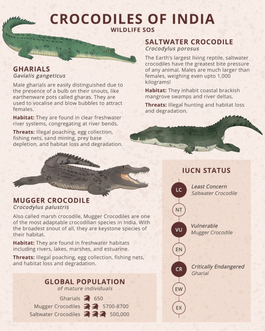
    • The Gharial is a fish-eating crocodile native to the Indian subcontinent.
    • They are a crucial indicator of clean river water.
    • It is also found in the rainforest biome of Mahanadi in Satkosia Gorge Sanctuary, Odisha.
    • Gharials are ‘Critically Endangered’ in the IUCN Red List of Species.
    • The species is also listed under Schedule I of the Wild Life (Protection) Act, 1972.
    • National Chambal Sanctuary along the river Chambal in Madhya Pradesh is the biggest protected area of the species.

    Recent findings of Gharial in Kaziranga

    • Gharials, distinguished by their long, narrow snouts, were believed to have disappeared from the Brahmaputra by the 1950s.
    • The female gharial, initially spotted in 2021, has grown to nearly adult size, providing hope for their reintroduction into the ecosystem.

    PYQ:

    [2013] Consider the following fauna of India :

    1. Gharial

    2. Leatherback turtle

    3. Swamp deer

    Which of the above is/are endangered?

    (a) 1 and 2 only

    (b) 3 only

    (c) 1, 2 and 3

    (d) None

  • Niranjan Panel set up to study Pollution Level in Cauvery

    Why in the News?

    The Karnataka government has formed an expert committee, headed by Niranjan, Chief Environment Officer of Karnataka State Pollution Control Board, to study the pollution level in the Cauvery.

    About Niranjan Panel

    • The panel will review and submit a report within 10 days to ascertain whether the Cauvery River water is polluted due to the inflow of sewage water, solid waste, industrial waste, and other types of pollutants.
    • The Cauvery water has lost its natural quality due to the pollutants and the health of citizens and aquatic animals are being adversely affected.

    About Cauvery River

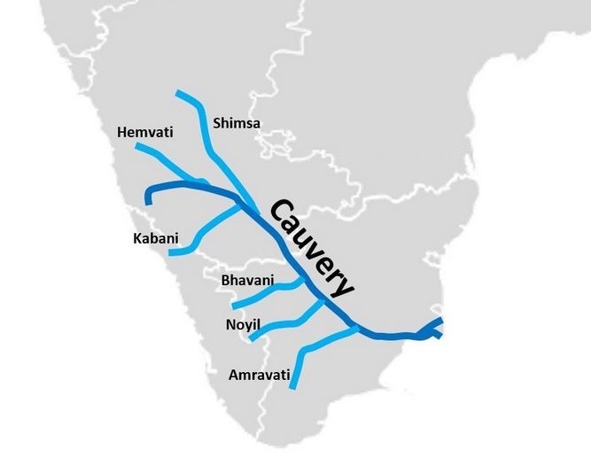
    • The Cauvery River, also spelled as ‘Kaveri’ and known as ‘Ponni’ in Tamil, originates from Talakaveri in the Brahmagiri range located in Karnataka’s Kodagu district.
    • It spans approximately 800 km, traversing through the states of Karnataka and Tamil Nadu, until it eventually reaches the Bay of Bengal.
    • The river’s catchment area covers regions in Tamil Nadu, Kerala, Karnataka, and the Union Territory of Pondicherry.
    • Key tributaries that join the Cauvery include Harangi, Hemavati, Kabini, Suvarnavathi, and Bhavani.
    • It remains perennial due to its dual reliance on both advancing and retreating monsoons for rainfall.
    • Protected areas in its basin: Cauvery WLS,  Biligirirangan Hills WLS,  Pushpagiri WLS,  Muthathi WLS,  Ranganathittu Bird Sanctuary,  Bhimeshwari WLS, Nagarhole NP; Bandipur NP.

    Challenges associated with the Cauvery River:

    • Direct discharge of untreated sewage and domestic waste from towns and cities along the Cauvery contaminates the water, leading to high bacterial loads and nutrient pollution.
    • Industries along the Cauvery, including textiles, dyeing, pharmaceuticals, and others, discharge effluents directly into the river.
    • Pesticides, herbicides, and fertilizers used in agricultural fields adjacent to the river are washed into the Cauvery during rain and irrigation.
    • Unregulated sand mining and dredging activities disrupt riverbeds and banks, altering natural flow patterns and habitat structures.
    • Introduction of non-native species like tilapia and African catfish, initially for aquaculture, has led to their proliferation in the Cauvery.

    Cauvery Water Dispute:

    • Since 1892, tensions existed between British-ruled Madras and Mysore
    • 1924 Agreement aimed to resolve but set the stage for future conflicts. Post-Independence, dam constructions sparked TN appeal
    • Cauvery Water Disputes Tribunal (CWDT) was established
    • Interim orders by the Cauvery River Authority (CRA) in 1998
    • CWDT’s 2013 award allocated water quantities among states
    • Monthly and annual water shares by Karnataka to Tamil Nadu
    • Normal Year, Karnataka must give 177.25 TMC to Tamil Nadu
    • Challenges arise during monsoons due to varying rainfall
    • Article 262 empowers Parliament for inter-state river disputes. The Seventh Schedule defines legislative authority over water resources
    • 2018: Cauvery was termed a “national asset” by SC with river water equality upheld
    • The Cauvery Management Board (CMB) was established by the Court for implementation
    • CWMA and CWRC were established for water regulation and data collection.


    PYQ:

    [2020] Which of the following Protected Areas are located in the Cauvery basin?

    1. Nagarhole National Park
    2. Papikonda National Park
    3. Sathyamangalam Tiger Reserve
    4. Wayanad Wildlife Sanctuary

    Select the correct answer using the code given below:

    (a) 1 and 2 only

    (b) 3 and 4 only

    (c) 1, 3 and 4 only

    (d) 1, 2, 3 and 4

  • Afforestation in Delhi Ridge

    Why in the News?

    The Delhi High Court is set to physically inspect the Central and Southern parts of Delhi Ridge to assess the extent of afforestation and cutting of trees in the area.

    Deforestation in Delhi Ridge:

    Over 308 hectares of the ecologically sensitive Delhi Ridge area has been encroached and another 183 hectares “diverted” for “non-forestry purposes”. ( Data by Central Empowered Committee (CEC) report to the Supreme Court, 2023.)

    About Delhi Ridge

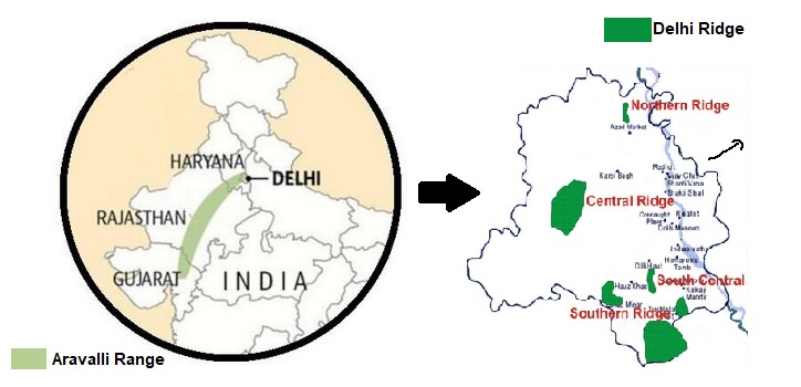
    • Delhi Ridge is located in the National Capital Territory of Delhi, extending as a northern extension of the ancient Aravalli Range.
      • Composed primarily of quartzite rocks, it spans approximately 35 kilometres from Tughlaqabad in the southeast to Wazirabad in the north along the Yamuna River.
    • Ecological Significance:
      • It acts as the “green lungs” of Delhi, providing crucial ecological services such as carbon sequestration and habitat for wildlife.
      • It protects Delhi from the hot desert winds originating from Rajasthan to the west.
      • It supports diverse flora and fauna, making Delhi one of the world’s most bird-rich capital cities.
      • Efforts are ongoing to maintain biodiversity through biodiversity parks and wildlife sanctuaries like the Northern Ridge Biodiversity Park and Asola Bhatti Wildlife Sanctuary.

    Geographical Features

    • The ridge is believed to be over 1.5 billion years old, making it an ancient geological formation compared to the Himalayas (50 million years old).
    • It functions as a watershed, dividing the Indus Plain to the west from the Gangetic Plain to the east within the Indo-Gangetic Plain.

    Administrative Divisions:

    • Divided into four main zones: Northern, Central, South-Central, and Southern Ridge.
    • Each zone has distinct characteristics and faces varying degrees of urban encroachment and conservation efforts.
  • Great Indian Bustard Recovery Plan

    bustard

    Why in the News?

    • The Compensatory Afforestation Fund Management and Planning Authority (CAMPA) approved Rs 56 crore for the next phase of the conservation program for the Great Indian Bustard (GIB) and the Lesser Florican for the 2024-2029 period.

    Note: Both the Bustard and Lesser Florican are critically endangered, with only 140 Bustards and less than 1,000 Lesser Floricans surviving.

    Back2Basics:  Compensatory Afforestation Fund Management and Planning Authority (CAMPA)

    Details
    Establishment
    • Established by the MoEFCC.
    • Legal Basis: Compensatory Afforestation Fund Act, 2016.
    Objective Ensure effective utilization of funds for compensatory afforestation, catchment area treatment, wildlife management, and forest resource development.
    Background Created due to the diversion of forest land for non-forest purposes; aimed at mitigating the loss of forest cover through compensatory afforestation.
    Structure National CAMPA Advisory Council: Provides policy advice and ensures inter-ministerial coordination.

    State CAMPAs: Manage funds and oversee implementation at the state level.

    Fund Utilization Funds are used for afforestation, forest ecosystem regeneration, wildlife protection, forest infrastructure, and conservation activities.
    Key Activities
    • Afforestation and reforestation
    • Wildlife management
    • Forest management
    • Soil and moisture conservation
    Financial Management
    • Managed by CAMPA at national and state levels;
    • Funds are non-lapsable and specifically allocated for forestry and wildlife activities.
    Monitoring and Reporting Includes regular audits and progress reports to ensure transparency and accountability in fund utilization and project implementation.
    Legal Framework Governed by the Compensatory Afforestation Fund Act, 2016

    CAMPA Guidelines.

    Impact and Significance Crucial for mitigating deforestation impacts, supporting ecological balance, biodiversity conservation, and sustainable forest management.

    About Great Indian Bustards

    • GIBs are the largest among the four bustard species found in India, the other three being MacQueen’s bustard, the lesser florican, and the Bengal florican.
    • GIBs’ historic range included much of the Indian sub-continent but it has now shrunken to just 10 percent of it.
      • Among the heaviest birds with flight, GIBs prefer grasslands as their habitats.
    • GIBs are mainly found in Desert National Park, Rajasthan.
    • Bustards face major threats, including habitat changes and collisions with power lines.
    • Protection accorded:
      • Birdlife International: uplisted from Endangered to Critically Endangered (2011)
      • Protection under CITES: Appendix I
      • IUCN status: Critically Endangered
      • Protection under Wildlife (Protection) Act: Schedule I

    What is the GIB Recovery Plan?

    • The proposal was prepared by the Wildlife Institute of India (WII).
    • The proposal includes:
      • Rewilding Bustards bred in ex-situ conservation centres,
      • Conducting detailed population studies, and
      • Developing artificial insemination techniques.

    Back2Basics: Wildlife Institute of India (WII)

    • WII is an autonomous institution under the Ministry of Environment, Forest and Climate Change.
    • It was established in 1982.
    • It is based in Dehradun, Uttarakhand.
      • Functions: It offers training programs, academic courses, and advisory in wildlife research and management.

    Why such a move?

    • Indicator Species: The GIB is a key indicator species of grassland habitat, signalling the health of these environments.
    • Population Decline: The population has declined from around 700 individuals to less than 150 due to habitat loss, predation, and death by overhead power lines.
    • Supreme Court Order: The Supreme Court recognized the threat from power lines and constituted an expert committee to assess the feasibility of overhead and underground electric lines in the bustard’s habitats.

    Conservation Efforts and Achievements

    • Recovery Plan: Initial efforts began between 2012-2013 with a long-term recovery project, which firmed up in 2016 with a Rs 33.85 crore funding outlay.
    • Funding and Agreements: The project was funded by the Compensatory Afforestation Fund, with a tripartite agreement in 2018 involving the Environment Ministry, Rajasthan Forest Department, and WII.
    • In-Situ Breeding: Conservation breeding began in 2019, resulting in a founder population of 40 GIBs at the Ramdevra centre.

    Achievements at Breeding Centres

    • Successful Breeding: Eggs collected from the wild were incubated and chicks were hand-reared. The breeding centres now have a founder population of 40 GIBs.
    • Scientific Reasoning: Creating a founder population prevents extirpation and captures genetic variability. The goal is to have at least 20 adult birds including 15 females.

    Future Plans

    • Next Phase (2024-2033): The immediate next phase will run until 2029, targeting the upgradation of the CBC at Ramdevra and the development of the Lesser Florican CBC at Sorsan.
    • Population Surveys: Surveys will be conducted in Rajasthan and other range states to monitor population status.
    • Release into the Wild: The most important target is releasing captive-bred GIBs into the wild, preceded by soft release in enclosures.

    PYQ:

    [2020] With reference to India’s Desert National Park, which of the following statements are correct?
    1. It is spread over two districts.
    2. There is no human habitation inside the Park.
    3. It is one of the natural habitats of the Great Indian Bustard.
    Select the correct answer using the code given below:
    (a) 1 and 2 only
    (b) 2 and 3 only
    (c) 1 and 3 only
    (d) 1, 2 and 3

    [2019] Consider the following statements:

    1. As per law, the Compensatory Afforestation Fund Management and Planning Authority exists at both National and State levels.
    2. People’s participation is mandatory in the compensatory afforestation programmes carried out under the Compensatory Afforestation Fund Act, 2016.

    Which of the statements given above is/are correct?

    (a) 1 only
    (b) 2 only
    (c) Both 1 and 2
    (d) Neither 1 nor 2

  • [pib] Metal Oxide Nano-composite developed for Environmental Clean-up

    Why in the News?

     A new metal oxide nanocomposite has been developed by The Institute of Advanced Study in Science and Technology (IASST)  that can help photocatalytic degradation of organic pollutants like dyes and pharmaceuticals and hence can be used as sustainable technologies for cleaning up the environment.

    Understanding Photocatalysis and Metal Oxides

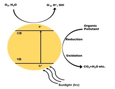
    • Photocatalysis is a process that uses light to accelerate chemical reactions, particularly useful for degrading harmful substances in water and air.
    • They facilitate this reaction without being consumed.
    • Examples: Titanium Dioxide (TiO2), Zinc Oxide (ZnO)  and Tungsten Trioxide (WO3)

    How do they work?

    • When exposed to light, these metal oxides generate electron-hole pairs.
    • These pairs are highly reactive and can break down pollutants into harmless by-products.
      • Work Efficiency: The overall efficiency of this process depends on several factors, including the choice of metal oxide, its crystal structure, light intensity, pollutant concentration, pH level, and the amount of catalyst used.
      • Optimisation: Optimizing these factors is crucial for maximising the degradation rates of pollutants. Adjustments in the type of metal oxide, light parameters, and other conditions can significantly enhance the photocatalytic efficiency.

    Breakthrough by IASST: NiTF Composite

    • The team developed a nanocomposite called NiTF, which stands for Nickel-doped Titanium Dioxide on Fuller’s Earth. 
    • This innovative material combines the photocatalytic properties of titanium dioxide with the adsorption capabilities of Fuller’s earth, a type of natural clay.

    What is Fuller Earth?

    • Fuller’s earth is a term for various clays used as an absorbent, filter, or bleaching agent.
    • Products labeled fuller’s earth typically consist of palygorskite or bentonite.
    • Primary modern uses include as absorbents for oil, grease, and animal waste, and as a carrier for pesticides and fertilizers

    Testing and Results

    • The NiTF nanocomposite was tested for its ability to decolorize methylene blue, a common dye.
      • Methylene blue is a persistent pollutant toxic to aquatic life, harmful to human health, and causes colour pollution in water bodies.
    • The results were impressive, with the composite achieving a 96.15% decolorization of the dye solution at a pH of 9.0 under visible light within 90 minutes.
    • Fuller’s earth enhanced the TiO2’s ability to adsorb pollutants, even in the absence of light.
    • This suggests that the NiTF nanocomposite could be a cost-effective solution for environmental photocatalysis, providing benefits even in low-light conditions.

    Potential Applications

    • Catalysis: The nanocomposite can enhance the efficiency of various chemical reactions.
    • Energy Storage: It has the potential to improve systems for storing energy.
    • Sensors: The material can be used to develop highly sensitive detection devices.
    • Optoelectronics: The nanocomposite can advance technologies that use light for electronic devices.
    • Biomedical Fields: It can be applied in medical treatments and diagnostics.
    • Coatings: The material can be used to create protective and functional surfaces.
    • Renewable Energy: It can facilitate water splitting to produce renewable energy.


    PYQ:

    [2015] With reference to the use of nanotechnology in the health sector, which of the following statements is/are correct?

    1. Targeted drug delivery is made possible by nanotechnology.
    2. Nanotechnology can largely contribute to gene therapy.

    Select the correct answer using the code given below:

    (a) 1 only
    (b) 2 only
    (c) Both 1 and 2
    (d) Neither 1 nor 2

  • Why Denmark has taxed cattle burps and farts?    

    Why in the news?

    Denmark will impose a tax on its livestock farmers for the greenhouse gases (GHGs) emitted by their cows, sheep, and pigs from 2030.

    What is it?

    Denmark plans to impose a tax on livestock farmers for greenhouse gases (GHGs) emitted by their cows, sheep, and pigs starting in 2030.

    • Tax Rates: Farmers would initially pay about $43 per metric ton of carbon dioxide equivalent produced by their livestock, increasing to around $108 by 2035.
    • Actual Cost: Due to a 60% income tax deduction, the actual cost per ton will start at 120 kroner ($17.3) and rise to 300 kroner ($43) by 2035.
    • Use of Tax Collection: The funds collected from the tax between 2030 and 2031 will be returned to the industry to support its green transition. The handling of proceeds will be revisited in 2032. The proposal includes the development of over 600,000 acres of new forest areas.

    How Do Cows and Sheep Produce Methane?

    • Ruminants like cows, sheep, goats, and buffaloes have a specialized digestive system with four stomach compartments, including the rumen. In the rumen, partially digested food ferments, producing methane.
    • Methane is released primarily through burping and farting as the animals regurgitate and chew cud to complete the digestive process. Ruminant digestive systems are responsible for 27% of all methane emissions from human activity.

    Why Are Methane Emissions a Problem?

    • Climate Impact: Methane is a potent greenhouse gas, responsible for 30% of warming since preindustrial times, second only to carbon dioxide. Over a 20-year period, methane is 80 times more potent at warming than carbon dioxide.
    • Ground-Level Ozone: Methane is the primary contributor to ground-level ozone formation, a highly irritating gas just above the Earth’s surface, contributing to 1 million premature deaths annually.
    • Rising Levels: Atmospheric methane levels have dramatically increased in recent years, with the NOAA reporting a record 17 parts per billion increase in 2021, surpassing the previous record set in 2020.

    Way forward: 

    • Dietary Adjustments: Introduce feed additives, such as seaweed or other natural supplements, that can reduce methane emissions during digestion in ruminants. This approach can significantly lower methane production without negatively impacting livestock health or productivity.
    • Improved Manure Management: Utilize advanced manure management practices, such as anaerobic digestion, to capture and convert methane emissions from decomposing animal waste into biogas. This not only reduces methane emissions but also provides a renewable energy source.

    Mains PYQ: 

    Q Describe the major outcomes of the 26th session of the Conference of the Parties (COP) to the United Nations Framework Convention on Climate Change (UNFCCC). What are the commitments made by India in this conference? (UPSC IAS/2021)

  • Himalayan Serow recorded at Assam’s Raimona National Park

    Why in the News?

    • A mainland serow aka. Himalayan Serow (Capricornis sumatraensis thar) was recorded at 96 metres above mean sea level in Raimona National Park, Assam.
      • This is the lowest elevation recorded for the species beyond Bhutan, its natural habitat.

    About Himalayan Serow

    Details
    About Herbivore species.

    Also known as Thar.

    Resembles a cross between a goat, a donkey, a cow, and a pig.

    Recognition Official state animal of Mizoram.
    Distribution
    • Found at altitudes between 2,000 metres and 4,000 metres (6,500 to 13,000 feet).
    • Found across the India-Bhutan border in Phibsoo Wildlife Sanctuary and Royal Manas National Park.
    • Present in eastern, central, and western Himalayas, but not in the Trans Himalayan region.
    Conservation Status
    • IUCN Red List: Vulnerable
    • CITES: Appendix I
    • The Wildlife Protection Act, 1972: Schedule I


    Back2Basics:  Raimona National Park 

    • Raimona National Park is a newly established protected area located in the Bodoland Territorial Region (BTR) of Assam.
    • It was officially declared a national park in June 2021, becoming the sixth national park in the state of Assam.
    • It shares its northern boundary with Bhutan, forming part of the transboundary conservation landscape.
    • It is characterised by dense forests, rivers, and grasslands. The park is part of the greater Manas Biosphere Reserve and serves as an extension of the Manas National Park.
    • The area is interspersed by the Sankosh River which flows through the park.

    Flora and Fauna:

    • Flora: The park boasts a rich biodiversity with various types of vegetation, including semi-evergreen forests, mixed deciduous forests, and patches of grassland.
    • Fauna: Hosts a variety of wildlife, including:
      • Mammals: Asian elephants, tigers, clouded leopards, golden langurs, Indian gaur, and several species of deer.
      • Birds: Home to numerous bird species, including hornbills, great pied hornbills, and various migratory birds.
      • Reptiles and Amphibians: The park also supports a diverse range of reptiles and amphibians, adding to its ecological richness.


    PYQ:

    [2011] The Himalayan Range is very rich in species diversity. Which one among the following is the most appropriate reason for this Phenomenon?

    (a) It has a high rainfall that supports luxuriant vegetative growth

    (b) It is a confluence of different bio-geographical zones.

    (c) Exotic and invasive species have not been introduced in this region.

    (d) It has less human interference.

  • Why the Thar Desert on the borders of India and Pakistan is getting greener?

    Why in the news?

    Rajasthan’s barren Thar Desert may turn green, says a recent study in the journal Earth’s Future.  

    About Thar Desert

    • The Thar Desert is the 18th largest subtropical desert globally and is one of the most densely populated deserts.
    • Approximately 40% of the human population in Rajasthan resides in the Thar Desert.
    • It extends from the Sutlej River and is bounded by the Rann of Kutch, the Aravalli Mountains, and the Indus River.
    • About 85% of the Thar Desert is located in India, with the remainder in Pakistan. 
    • In India, it spans across Rajasthan, Gujarat, Haryana, and Punjab as well.
    • Civilizations are believed to have thrived in the Thar region around 50,000 years ago across the extinct Saraswati River.
    • The Desert National Park (home to the endangered Great Indian Bustard, desert fox, desert cat, blackbuck, and Indian gazelle) is situated in the Thar Desert in the northwest Indian state of Rajasthan.

    Why the thar desert getting greener?

    • Climate Change Effects:
        • Alteration of Weather Patterns: Climate change is causing shifts in rainfall distribution in the thar desert area.
        • Potential for Vegetation Growth: The increased precipitation could provide favorable conditions for vegetation growth, contributing to the greening of the desert.
    • Indian Monsoon Dynamics:
        • Westward Extension of Indian Monsoon: The Indian monsoon, known for bringing heavy rainfall to eastern India, is now extending further westward into regions like the Thar Desert.
        • Impact on Moisture and Rainfall: This change in monsoon dynamics could lead to increased moisture and rainfall in the desert region, facilitating the growth of vegetation.
    • Expansion of Indian Ocean Warm Pool (IOWP):
        • Influence on Monsoon Patterns: The Indian Ocean Warm Pool (IOWP) influences monsoon patterns and rainfall distribution over the Indian subcontinent.
        • Westward Expansion due to Climate Change: Climate change is causing the IOWP to expand westward, potentially resulting in increased rainfall over semi-arid regions like the Thar Desert and promoting greening.
    • Water Management Practices:
        • Contribution to Greening: Effective water management practices, such as rainwater harvesting and irrigation techniques like johad, kuis, and kunds, may be playing a role in the greening of the Thar Desert.
        • Utilization of Water Resources: By harnessing and efficiently utilizing available water resources, local communities and authorities can support vegetation growth and ecosystem restoration efforts in the desert.
    • Introduction of Irrigation  
      • Commercial Cropping: Irrigation was introduced during British colonial rule in the 19th and 20th centuries to convert arid and semi-arid ecosystems into cropland.
      • Restrictions on Grazing: The right to graze animals was restricted to landowners who cultivated crops, leading to the transformation of nomadic pastoralists into sedentary agropastoralists.
    Sustainability of this transformation

    • Recent greening activities, largely on arid scrub savannahs, have threatened species adapted to such climates and have been linked to locust outbreaks.
    • The Indira Gandhi Canal project in the 1980s led to extensive crop cover in the Thar Desert, resulting in areas becoming infertile due to waterlogging and salinity.
    • Planting invasive species, such as prosopis juliflora and acacia tortilis, has led to habitat degradation and biodiversity loss.


    PYQ:

    [2018] Which of the following leaf modifications occur(s) in the desert areas to inhibit water loss?

    1. Hard and waxy leaves
    2. Tiny leaves
    3. Thorns instead of leaves

    Select the correct answer using the code given below:

    (a) 2 and 3 only

    (b) 2 only

    (c) 3 only

    (d) 1, 2 and 3

    [2020] The process of desertification does not have climate boundaries. Justify with examples.

    [2013] Major hot deserts in northern hemisphere are located between 20-30 degree north and on the western side of the continents. Why?  


  • South India’s First and Largest Leopard Safari at Bannerghatta Biological Park

    Why in the News?

    South India’s first and the country’s largest leopard safari was inaugurated at the Bannerghatta Biological Park (BBP).

    About Bannerghatta Biological Park 

    • BBP is located near Bangalore and was established in 2002.
    • It spans an area of approximately 731.88 hectares, situated within the larger Bannerghatta National Park, which covers around 25,000 acres.
    • The park was created to facilitate the conservation of wildlife, promote tourism, and educate the public about wildlife and conservation efforts.
    • River Suvarnamukhi stream, the main source of water for the animals of the park, runs through the centre of the park.

    Leopards in India

    • The Indian Leopard (Panthera pardus fusca) is a leopard subspecies widely distributed on the Indian subcontinent.
    • These are the smallest of the big cats.
    • They are known for their ability to adapt to a variety of habitats.
    • They are strong and agile predators that can climb trees and drag their prey up for safety.
    • Conservation Status:
    1. IUCN Red List: Vulnerable
    2. CITES: Appendix I
    3. Wildlife (Protection) Act, 1972: Schedule I

    Do you know?

    As per, Status of Leopards in India Report, 2022:

    • India’s leopard population is estimated at 13,874 individuals.
    • Madhya Pradesh houses the largest population of leopards in the country – 3907 (2018: 3421), followed by Maharashtra (2022: 1985; 2018: 1,690), Karnataka (2022: 1,879 ; 2018: 1,783) and Tamil Nadu (2022: 1,070; 2018: 868).


    PYQ:

    [2012] Consider the following:

    1. Black-necked crane
    2. Cheetah
    3. Flying squirrel
    4. Snow leopard

    Which of the above are naturally found in India?

    (a) 1, 2 and 3 only
    (b) 1, 3 and 4 only
    (c) 2 and 4 only
    (d) 1, 2, 3 and 4