đŸ’„Join UPSC 2027,2028 Mentorship (July Batch) + XFactor Notes & Microthemes PDF

Subject: Geography

  • The heavy rainfall and the crazy Banglore flood: A case to study

    floodContext

    • The recent events of heavy downpours in short period of time and the recent example of Banglore flood, highlights how cities in India and elsewhere need to adapt to climate change as it brings more extreme rainfall in the future.

    What is heavy downpour?

    • A downpour or cloudburst is a sudden and unexpected heavy fall of rain.
    • It is usually local in nature and of brief duration. Most so-called cloudbursts occur in connection with thunderstorms.
    • Heavy downpour in short period causes flood, damage to buildings and infrastructure can disrupt transport, communications and connectivity, loss of crops and livestock.

    The heavy rainfall and the Banglore flood causes

    • Rise in built up area: Lakes and natural depressions may not always fill up during many monsoons so the people who are unaware of hydrology tempts to build and buy in the catchment areas of water-bodies, which will be disastrous when it rains heavily as there is rise in the quantity.
    • Water-logging: rainwater and sewage water are forced to build up, which results in water-logging. The highway acts as a dam for the water ,Garbage frequently clogs drains, which limits the flow of sewage, and they are too small to support the weight of the expanding population.
    • Physical shrinkage of water-bodies: Destruction of lakes is a major issue .lakes can store the excess water and regulate the flow of water however the pollution of natural water bodies and converting them for development purposes has increased the risks of floods. Unplanned growth, Rise in population, rise in the built up areas along streams, canals, around the lakes, leaving no storage capacity.
    • Compromised runoff potential and health hazards: Choked and encroached drains and lakes, ill designed infrastructure and missing pipes compromising run off potential. Not only the physical quantity of the runoff that poses a hazard. When polluted drains and lakes overflow, the flood can pose a health hazard especially to vulnerable and exposed marginal communities living in informal settlements.
    • Zero or limited ability to allow infiltration of water: Encroachments in and around wetlands and green lands harming the natural way of water infiltration and ground water recharge.
    • Lack of vision in rain water harvesting: Ignorance towards the tradition rain water harvesting techniques and no or limited vision for creating new systems of rain water harvesting. Exceptionally heavy monsoon rains have been exacerbated by poor urban planning in the Indian tech hub, showing the need for improved water systems.

    floodWhat are the reasons behind the frequent floods in urban areas?

    • Meteorological factors: change in the weather patterns, increase in the temperature leading to heavy rainfall, sudden downpour, cloudburst, thunderstorms, hailstorms etc.
    • Hydrological factors: Natural surface infiltration rate, soil moisture level, presence or absence of Overbank flows, Presence of impervious cover, the occurrence of high tides impeding the drainage in coastal cities.
    • Man-Made factors:
      • Unplanned urbanization: Unplanned settlement is one of the main cause of urban flooding. Blocking of natural drainage pathways through construction activity and encroachment on catchment areas, streams, rivers, lakebeds. Reduced infiltration and ground water recharge of water, destruction of lakes, Land-use changes (e.g. surface sealing due to urbanization, deforestation) increase runoff and sedimentation. Inefficiency or non-maintenance of infrastructure etc.
      • Outdated Drainage systems: The old and ill-maintained drainage system is one of the main factor making cities in India vulnerable to flooding
      • Encroachments on and around water-bodies: Illegal Habitations started growing into towns and cities alongside rivers and watercourses. As a result of this, the capacity of the natural drains has decreased, resulting in flooding.
      • Climate Change: Climate change due to various anthropogenic events has led to extreme weather events, increasing temperature which resulting in heavy rainfall in one part while drought and dry spells in other.
      • Poor Solid Waste Management System: Indiscriminate disposal of solid waste, poor waste management system, clogging drains because of accumulation of non-biodegradable wastes are major concerns. Domestic, commercial and industrial waste and dumping of it into the drains also contribute significantly to reducing their capacities.
      • Reduced Seepage: use of hard and non-porous construction material making the soil impervious, reducing the seepage capability in no of cities in India.
      • Weak Implementation and lack of awareness:Even with provisions of rainwater harvesting, sustainable urban drainage systems, etc, in regulatory mechanisms like the Environmental Impact Assessment (EIA), adoption at user end as well as enforcement agencies remains weak.
      • No Community Participation:Flood control measures planned without participation of the affected community are unsustainable as they do not meet the needs of relevant stakeholders.

    What can be done to prevent the urban floods and prevent losses?

    • Developing climate Resilient Infrastructure: using permeable material for roads and pavement, green roofs and harvesting systems in buildings. To reduce the burden of road infrastructure in cities Outer Ring Road should be explored. Innovative approaches like Sponge Cities wetland restoration, flushing systems using collected rooftop water, public spaces as flexible water retention facilities can be applied to Indian urban areas.
    • Use of technology in Early Warning Systems and Communication: Early-warning systems using sensors across waterbodies and drains, and a network of communication for hotspots of emerging flood risk in the wet-season should be put in place. Providing real-time data where traditional systems fail. Tools such as predictive precipitation modelingcan help do that and are also able to link it with the adaptive capacity of urban land use.
    • Proper management and regular upgrade of Urban Drainage System: drains need to be cleaned on a regular basis to permit the free flow of water .Proper management of the drainage system is necessary to ensure that the water does not get stored in one place. Watershed management and emergency drainage plan should be clearly enunciated in policy.
    • Rainwater Harvesting: It will serve the twin purposes of lowering the peak runoff and raising the groundwater table. Many municipal corporations in India have already made rainwater harvesting compulsory. 
    • Conservation of Water Bodies: Urban water bodies like lakes, tanks, and ponds also play a very important role in the management of urban flooding by reducing the flood water run-off by capturing it.
    • Holistic approach: Improved monitoring, forecasting, and decision-support systems. Find out the different method for improving the preparedness for urban flooding.
    • Responsibility on every stakeholder: Locally, citizens, local ward officials and staff will need to work together to minimize dumping of solid waste and garbage in storm-water drains. As this is a socio –political problem, public participation awareness and responsibility of citizen is the need of the hour. To develop a long-lasting solution, all parties must acknowledge the issues and adopt a thorough strategy.

    What we as citizens can do on a personal level to prevent the urban environment?

    • Raising voice at all available forums and platforms
    • Making politicians and bureaucrats accountable
    • Refuse to buy a house in the encroached lands.
    • Applying methods of rain water harvesting on individual level.

    Way ahead

    • Exceptionally heavy monsoon rains have been exacerbated by poor urban planning in the Indian tech hub, showing the need for improved water systems.
    • Urbanization is a global and inevitable process, and with cities as engines of the economy, built-up areas will continue to grow. But we need to draw upon these experiences and the growing perils of climate change and extreme rain events and change course.
    • According to UN projections, by 2050 more than 68% of the world’s population could be concentrated in urban areas.
    • In this context, resilience-based strategies should be adopted to improve the capacity to handle the crisis arising out of climate change.
    • Wetlands are the kidneys of the earth, let’s keep it healthy.


    Mains Question

    Q. What are the factors causing flood in the urban cities? What are the measures to prevent the urban flooding keeping in mind the sustainable development? Discuss.


    UPSC 2023 countdown has begun! Get your personal guidance plan now! (Click here)


  • Southwest Monsoon begins early Withdrawal/Retreat

    The southwest monsoon rainfall, 7% more than normal, has started to withdraw.

    What is Monsoon Withdrawal/Retreat?

    • In India, retreating monsoon is the withdrawal of south-west monsoon winds from North India.
    • The withdrawal is gradual and takes about three months.
    • With the retreat of the monsoons, the clouds disappear and the sky becomes clear. The day temperature starts falling steeply.
    • Monsoon rains weaken all over India except few southeastern states.
    • It is helpful in Rabi crop cultivation.

    Factors affecting the retreat

    Two predominant factors cause the phenomenon:

    (1) Land topography

    • First, the low mountain range in each region runs from north to south, shielding it from west-bound winds that trigger summer monsoon.
    • After summer, the range aids in the ‘orographic lift’ or rising of east-bound air mass from a lower to higher elevation, forming clouds and resulting in rain.

    (2) Atmospheric convection

    • The second factor is atmospheric convection or vertical movement of air.
    • As the earth is heated by the sun, different surfaces absorb different amounts of energy and convection may occur where the surface heats up very rapidly.
    • As the surface warms, it heats the overlying air, which gradually becomes less dense than the surrounding air and begins to rise.
    • This condition is more favorable from September to February because of the role played by sea surface temperature or water temperature.

    Immediate factors influencing withdrawal

    • The withdrawal of the monsoon is based on meteorological conditions such as-
    1. Anti-cyclonic circulation (dry air that is the opposite of a cyclone)
    2. Absence of rain in the past five days and
    3. Dry weather conditions over the region

    When does it occur?

    • The monsoon withdrawal is a long-drawn process and extends into mid-October, though the IMD considers September 30 to be the final day of the season over India.
    • The rain after that is categorised as “post-monsoon” rainfall.

    Try this PYQ:

    Q.The seasonal reversal of winds is the typical characteristic of:

    (a) Equatorial climate

    (b) Mediterranean climate

    (c) Monsoon climate

    (d) All of the above climates


    [wpdiscuz-feedback id=”9s1wlwig7j” question=”Please leave a feedback on this” opened=”1″]Post your answers here.[/wpdiscuz-feedback]


    Also read:

    Various terms related to Indian Monsoon


    UPSC 2023 countdown has begun! Get your personal guidance plan now! (Click here)

  • What is Karoo-Ferrar Large Igneous Province?

    karoo

    A new study shows that a decline in continental plate movement likely controlled the onset and duration of many of the major volcanic events throughout Earth’s history.

    Why is the news?

    • Previous studies have linked major volcanic eruptions with past mass extinctions and disturbances in the global climatic, environmental and the carbon cycle.
    • Large igneous province volcanism, formations due to major volcanic eruptions occurring throughout Earth’s history, released large quantities of greenhouse gasses and toxic compounds into the atmosphere.
    • The sea warmed up by 4°C to 10°C, even at low- to mid-latitudes, the study noted.
    • Increased acidic levels and a lack of oxygen drove major ocean extinctions.
    • Large-scale volcanism took place in southern Africa, Antarctica and Australia. This is known as the Karoo-Ferrar Large Igneous Province.

    About Karoo-Ferrar Large Igneous Province

    • The Karoo and Ferrar Large Igneous Provinces (LIPs) are two large igneous provinces in Southern Africa and Antarctica respectively, collectively known as the Karoo-Ferrar, Gondwana, or Southeast African LIP associated with the initial break-up of the Gondwana supercontinent.
    • Its flood basalt mostly covers South Africa and Antarctica but portions extend further into southern Africa and into South America, India, Australia and New Zealand.
    • Karoo-Ferrar formed just prior to the breakup of Gondwana in the Lower Jurassic epoch, about 183 million years ago.
    • This time corresponds to the early Toarcian anoxic event and the Pliensbachian-Toarcian extinction.


    UPSC 2023 countdown has begun! Get your personal guidance plan now! (Click here)

  • Urban floods mitigation

    floods
    Context

    • Bengaluru floods are alarming us to go for robust disaster management strategies.

    What is flood?

    • Floods are the most frequent type of natural disaster and occur when an overflow of water submerges land that is usually dry. Floods are often caused by heavy rainfall, rapid snowmelt or a storm surge from a tropical cyclone or tsunami in coastal areas.

    Causes of frequent urban floods

    Natural

    • Meteorological Factors:Heavy rainfall, cyclonic storms and thunderstorms causes water to flow quickly through paved urban areas and impound in low lying areas.
    • Hydrological Factors: Overbank flow channel networks, occurrence of high tides impeding the drainage in coastal cities.
    • Climate Change: Climate change due to various anthropogenic events has led to extreme weather events.

    Anthropological

    • Unplanned Urbanization:Unplanned Urbanization is the key cause of urban flooding. A major concern is blocking of natural drainage pathways through construction activity and encroachment on catchment areas, riverbeds and lakebeds.
    • Destruction of lakes: A major issue in India cities. Lakes can store the excess water and regulate the flow of water. However, pollution of natural urban water bodies and converting them for development purposes has increased risk of floods.
    • Unauthorised colonies and excess construction: Reduced infiltration due paving of surfaces which decreases ground absorption and increases the speed and amount of surface flow
    • Poor Solid Waste Management System: Improper waste management system and clogging of storm-water drains because of silting, accumulation of non-biodegradable wastes and construction debris.
    • Drainage System:Old and ill maintained drainage system is another factor making cities in India vulnerable to flooding.
    • Irresponsible steps: Lack of attention to natural hydrological system and lack of flood control measures.

    floodsImpact of the devastation due to floods:

    • On economy: Damage to infrastructure, roads and settlements, industrial production, basic supplies, post disaster rehabilitation difficulties etc.
    • On human population and wildlife:Trauma, loss of life, injuries and disease outbreak, contamination of water etc.
    • On environment:Loss of habitat, tree and forest cover, biodiversity loss and large scale greenery recovery failure.
    • On transport and communication: Increased traffic congestion, disruption in rail services, disruption in communication- on telephone, internet cables causing massive public inconvenience.

    Solutions for effective flood management

    • Improved flood warning systems: effective flood warning systems can help take timely action during natural calamities and can save lives. Pre-planning can significantly reduce the effects of floods, giving people time to migrate to safer locations and stock up essentials.
    • Building flood-resilient housing systems: concreting floors can be very useful during floods. Houses should be water proofed and electric sockets should be placed at higher levels up the walls to reduce the chances of shocks.
    • Constructing buildings above flood levels: buildings should be constructed a metre above from the ground to prevent flood damage and evacuation during floods.
    • Resilience to Climate change: drastic climate changes have increased the frequency of natural disasters in many parts of the world. Governments should bring about environment-friendly policy level changes and eliminate the ones hazardous to the environment to tackle the problem of global warming.
    • Create wetlands and encourage reforestation: creating more and more wetlands can help soak up excessive moisture since wetlands act as sponges. Wooded areas can also slow down heavy water flow, minimizing the effects of floods. Reforesting upstream regions can significantly reduce the effects of flood damage.
    • Improve soil conditions: improper soil management, animal hooves, and machinery can make soil compacted. As a result, instead of holding water in and absorbing moisture, the water runs off immediately. Properly drained soil can absorb large amounts of rainwater and can prevent it from flowing into the rivers.
    • Installing flood barriers: these are flood gates designed to prevent the area behind the barrier from flooding. They can also be kept around buildings to keep floodwaters outside the boundary created.
    • Development of GIS– Geographical Information System (GIS) based National Database: for disaster management. GIS is an effective tool for emergency responders to access information in terms of crucial parameters for disaster-affected areas.
    • Developing a Federal flood management plan: with responsibilities of union and state clearly defined.
    • Creation of 2nd flood commission: (Rashtriya Barh Aayog, created in 1976) to study the flood situation in India under rising challenges of climate change and propose a national-level flood resilience and management plan.

    Way forward

    • Resilience of people: The rapid transformation in rainfall characteristics and flooding patterns demand building people’s resilience.
    • Reconsider projects: Construction projects that impede the movement of water and sediment across the floodplain must be reconsidered.
    • Use of technology: At the same time, climate-imposed exigencies demand new paradigms of early-warning and response systems and securing livelihoods and economies.

    Conclusion

    • We can learn to live with nature, we can regulate human conduct through the state and we can strategically design where we build. We need to urgently rebuild our cities such that they have the sponginess to absorb and release water without causing so much misery and so much damage to the most vulnerable of our citizens.

    Mains question

    Q. We need to urgently rebuild our cities such that they have the sponginess to absorb and release water. Discuss the statement in context of urban flood management strategy in India.

    UPSC 2023 countdown has begun! Get your personal guidance plan now! (Click here)

  • Forest fire management for positive sustainable forest growth

    forest fireContext

    • Forest fires are becoming more common and wildfires are destroying nearly twice as much tree cover globally as they did in 2001.

    Why in news?

    • Climate change is driving more intense and widespread forest fire by fuelling more extreme heat and deepening drought, which dries out forests.

    How to define forest fire?

    • A wildfire, forest fire, bushfire, wildland fire or rural fire is an unplanned, uncontrolled and unpredictable fire in an area of combustible vegetation starting in rural and urban areas.

    What causes forest fires?

    • Human activities: Forest fires can be caused by a number of natural causes, but officials say many major fires in India are triggered mainly by human activities.
    • Climate change: Emerging studies link climate change to rising instances of fires globally, especially the massive fires of the Amazon forests in Brazil and in Australia in the last two years. Fires of longer duration, increasing intensity, higher frequency and highly inflammable nature are all being linked to climate change.
    • Season: In India, wildfires are most commonly reported during March and April, when the ground has large quantities of dry wood, logs, dead leaves, stumps, dry grass and weeds that can make forests easily go up in flames if there is a trigger.
    • Natural reasons: Under natural circumstances, extreme heat and dryness, friction created by rubbing of branches with each other also have been known to initiate fire.

    forest fire

    Key fact

    7.4 million acres of forest are getting burnt annually now an area roughly the size of Belgium.

    What factors make forest fires a concern?

    • Carbon emission: They act as a sink, reservoir and source of carbon.
    • Livelihood loss: In India, with 1.70 lakh villages in close proximity to forests (Census 2011), the livelihood of several crores of people is dependent on fuelwood, bamboo, fodder, and small timber.
    • Destruction of animals’ habitat: Heat generated during the fire destroys animal habitats. Soil quality decreases with the alteration in their compositions.
    • Soil degradation: Soil moisture and fertility, too, is affected. Thus forests can shrink in size. The trees that survive fire often remain stunted and growth is severely affected.

    Measures to curb Forest fires

    1) National Action Plan on wild fires

    • The MoEFCC has prepared a National Action Plan on wild fire in 2018 after several rounds of consultation with all states and UTs.
    • The objective of this plan is to minimize forest fires by informing, enabling and empowering forest fringe communities and incentivizing them to work in tandem with the State Forest Departments.
    • The plan also intends to substantially reduce the vulnerability of forests across diverse forest ecosystems in the country against fire hazards, enhance capabilities of forest personnel and institutions in fighting fires and swift recovery subsequent to fire incidents.

    2) Forest Fire Prevention and Management scheme

    • The MoEFCC provides wildfire prevention and management measures under the Centrally Sponsored Forest Fire Prevention and Management (FPM) scheme.
    • The FPM is the only centrally funded program specifically dedicated to assist the states in dealing with forest fires.
    • The FPM replaced the Intensification of Forest Management Scheme (IFMS) in 2017. By revamping the IFMS, the FPM has increased the amount dedicated for forest fire work.
    • Funds allocated under the FPM are according to the 90:10 ratio of central to state funding in the Northeast and Western Himalayan regions and 60:40 ratio for all other states.
    • Nodal officers for forest fire prevention and control have been appointed in each state.

    forest fireWay forward

    • Awareness should be created among the villagers residing near the forests with respect to the long-term ill effects of forest fires.
    • Measures to prevent wildfires have to be taken before summer season when fires are prevalent.
    • Local people should be given skills to use online portals or mobile apps in order to monitor the forests for fires and inform forest authorities regarding the same.

    Mains question

    Q. Climate change is driving more intense and widespread forest fires by fueling more extreme heat and deepening drought. Why forest fires are cause of concern? Discuss our preparedness level for the same in the above context.

    UPSC 2023 countdown has begun! Get your personal guidance plan now! (Click here)

  • Dam safety bill for sustainable water management

    dam safety billContext

    • Integrated risk assessment of dam safety required to prevent human-made disasters: Experts

    Why in news?

    • The recent floods in the Mahanadi basin in Odisha have brought to the fore, the faulty management of dam safety, which were built to mitigate floods and not be the cause of them.

    What is a dam?

    • A dam is a barrier that stops the flow of water and results in the creation of a reservoir. Dams are mainly built in order to produce electricity by using water. This form of electricity is known as hydroelectricity.
    • Reservoirs created by dams not only suppress floods but also provide water for activities such as irrigation, human consumption, industrial use, aquaculture, and navigability.

    Key facts

    India has 5,745 large dams according to the National Register of Large Dams, 2019, prepared by the Central Water Commission. Some 5,334 of them are operational and the remaining 411 are under construction.

    What is the Dam Safety Act, 2021?

    • The Act comprehensively postulates for surveillance, inspection, operation and maintenance of dams to prevent disasters.

    Features

    • National Committee on Dam Safety (NCDS): It will be constituted and will be chaired by the chairperson, Central Water Commission. Its’ functions will include formulating policies and regulations regarding dam safety standards and prevention of dam failures, analyzing the causes of major dam failures, and suggesting changes in dam safety practices.
    • National Dam Safety Authority (NDSA): It will be headed by an officer, not below the rank of an Additional Secretary, to be appointed by the central government. The main task of this authority includes implementing the policies formulated by the NCD, resolving issues between State Dam Safety Organisations (SDSOs), or between an SDSO and any dam owner in that state, specifying regulations for inspection and investigation of dams.
    • State Dam Safety Organisation (SDSO): Its functions will be to keep perpetual surveillance, inspection, monitoring the operation and maintenance of dams, keeping a database of all dams, and recommending safety measures to owners of dams.
    • Dam Safety Unit: The owners of the specified dams are required to provide a dam safety unit in each dam. This unit will inspect the dams before and after the monsoon session, and during and after any calamity or sign of distress.
    • Emergency Action Plan: Dam owners will be required to prepare an emergency action plan, and carry out risk assessment studies for each dam at specified regular intervals.
    • Certain offences: The act provides for two types of offences – obstructing a person in the discharge of his functions, and refusing to comply with directions issued under the proposed law.

    dam safetyDam rehabilitation and improvement programme DRIP

    • Government of India, with financial assistance from the World Bank initiated Dam Rehabilitation and Improvement Project (DRIP) in April 2012 with an objective to improve the safety and operational performance of selected existing dams along with dam safety institutional strengthening with system wide management approach. It was a State Sector Scheme with Central component.

    Do you know?

    Four dams — Mullaperiyar, Parambikulam, Thunakkadavu and Peruvaripallam — located in Kerala but owned, operated and maintained by the Tamil Nadu Government.

    Conclusion

    • The bill aims to help all States and Union Territories to adopt uniform dam safety procedures which will ensure safety of dams and safeguard benefits from such dams. In order to iron out the differences and issues in the bill, central government should take the state governments into consideration and hold talks with all the stakeholders. This will go a long way in ensuring the safety of dams in India, which ranks third in the world in terms of number of large dams.

    Mains question

    Q. India, which ranks third in the world in terms of number of large dams. Ageing dams poses several challenges for India. In this context discuss the importance of dam safety bill 2021.


    UPSC 2023 countdown has begun! Get your personal guidance plan now! (Click here)

  • In news: Continental Drift Theory

    This newscard is an excerpt from the original article published in TH which talks about the specie Lemurs who are supposed to jump into seas to find India which got drifted away from the Madagascar.

    Study on Lemurs

    • Many life forms in Madagascar have affinities to lineages found in India (3,800 km away) rather than Africa (413 km). This posed a ‘difficult enigma’ to naturalists.
    • One such species is the Lemurs.
    • We most likely see lemurs in a Hollywood animation movie; singing, dancing and playing pranks.
    • Zoologists was perplexed by the presence of lemurs, their relatives, and their fossils in Madagascar and India, but not in nearby Africa or the Middle East.
    • In the 1860s, he proposed that a large island or continent must have once existed between India and Madagascar, serving as a land bridge.
    • Over time, this island had sunk. He called this proposed island Lemuria.

    Existence of such Island in Indian legends

    • Tamil revivalists such as Devaneya Pavanar also took up the idea, in the form of a Tamil civilisation, lost to the sea as described in literature and in Pandyan legends.
    • They called this submerged continent Kumari Kandam.

    Basis of this legend: Continental Drift Theory

    • In the early 20th century, German geologist Alfred Wegener published a paper on his theory called continental drift.
    • It is a hypothesis that Earth’s continents were moving across Earth, and sometimes, even colliding into one another.
    • According to Wegener’s theory, Earth’s continents were once joined as a single, giant landmass, which he called Pangaea.
    • But over time, Pangaea broke apart and formed the continents as we know them today.
    • Wegener couldn’t explain why this phenomenon was happening, so at the time, his theory was heavily criticized by his colleagues.
    • But over the years, technological advances allowed scientists to study the Earth more closely, and geologists started to build on Wegener’s theory.

    Rise over to Plate Tectonics

    • Discoveries like seafloor spreading helped explain the “why” behind continental movement, and eventually, Wegener’s initial continental drift theory morphed into plate tectonic theory.
    • And now, the idea that Earth’s crust is slowly moving beneath our feet is widely accepted.

    The Seven Major Tectonic Plates

    There are seven major plates, and dozens of minor plates, that make up the outer crust of the Earth. The big seven are:

    1. North American plate
    2. Eurasian plate
    3. Pacific plate
    4. South American plate
    5. African plate
    6. Indo-Australian plate
    7. Antarctic plate


    The areas between these plates are known as plate boundaries, and their interactions cause some crazy things to happen on Earth’s surface.

    There are three types of plate boundaries:

    1. Divergent boundary
    • A divergent boundary is when two plates move away from each other, which creates a fracture in the lithosphere.
    • A well-known divergent boundary is the Mid-Atlantic Ridge, which runs approximately 10,000 miles from the Arctic Ocean all the way down to the south of Africa.
    1. Convergent boundary
    • A convergent boundary is when two plates collide with one another.
    • If the collision is between oceanic crust and continental crust, the denser oceanic crust slides underneath the other plate, which is a process known as subduction.
    • When two continental crusts collide, the rock folds and lifts at the boundary, creating mountains like the Himalayas (where the Indian plate meets the Eurasian plate).
    1. Transform Boundary
    • When two plates move parallel to one another, their meeting point is called a transform boundary. The friction causes tension.
    • Eventually, that tension needs to be released, which can cause earthquakes.
    • The San Andreas Fault is a well-known major transform boundary between the North American and Pacific plates—it caused the infamous San Francisco earthquake of 1906.

    How do we apply this theory here?

    • A landmass called Gondwana, split into two 165 million years ago — one containing what is now Africa and South America, the other comprising India, Madagascar, Australia and Antarctica.
    • Around 115 million years ago, Madagascar and India together broke free.
    • Around 88 million years ago, India moved northward, dropping a few parcels of land along the way to form Seychelles.
    • It joined the Eurasian mass 50 million years ago giving rise to the Himalayas and South Asia that we are familiar with.
    • Around 115 million years ago, it was the dinosaurs that ruled. Many life forms had not even evolved.

    Substantiation to this study

    (1) Fossil study

    • Supporting the Gondwana breakup, dinosaur fossils found in India and Madagascar are closely related and do not resemble species found in Africa and Asia.
    • Fragments of Laplatosaurus madagascarensis have been found in both India and Madagascar.

    (2) Molecular clocks

    • A powerful technique, the molecular clock, is used to estimate the time when two forms of life diverged from each other.
    • It is based on the observation that evolutionary changes in the sequence of an RNA or a protein molecule occur at a fairly constant rate.
    • The difference in the amino acids of, say the haemoglobin of two animals can tell you how long ago their lineages diverged.
    • Molecular clocks corroborate well with other evidence, such as the fossil record.
    • South India and Sri Lanka have only two genuses of the cichlid family of freshwater and brackish-water fishes — the Etroplus (a food fish in Kerala, where it is called pallathi) and Pseudetroplus.
    • Molecular comparisons show that the nearest relatives of Etroplus are found in Madagascar, and their common ancestor diverged from African cichlids 160 million years ago.

    India’s pivotal position

    • India occupies a pivotal position in the distribution of life forms in Asia, Madagascar and Africa. Gondwana creatures moved out of India.
    • Others crossed over to stay. For example, Asian freshwater crabs (Gecarcinucidae) are now found all over Southeast Asia but their most recent common ancestor evolved in India.
    • Fossil finds in the Vastan lignite mine in Gujarat by researchers have identified the earliest Indian mammal, a species of bat, and the earliest euprimate, a primitive lemur.
    • These were dated 53 million years ago, around the time (or just before) the India-Eurasian plates collided.

    What about the lemurs?

    • Madagascar is a large island, with a variety of climatic conditions. Evidence favours an ancestor primate crossing over from Africa.
    • No monkey, ape or large predator managed the crossing, so dozens of lemur species proliferated.
    • In India, we have the lorises, which are the closest extant relatives of the lemurs.
    • These are shy, nocturnal forest dwellers, with large, appealing eyes.
    • They are also believed to have survived oceanic rides from Africa.
    • They are mostly found in the Northeastern States (slow loris), and where Karnataka, Kerala and Tamil Nadu meet (slender loris).


    UPSC 2023 countdown has begun! Get your personal guidance plan now! (Click here)

  • What are Tetrapods?

    In Mumbai, the unusual vibrations (like earthquakes), coinciding with high-tide times, were the result of the relocation of tetrapods as part of the ongoing Coastal Road Project (MCRP).

    What are tetrapods?

    • Tetra pod in Greek means four-legged.
    • These are four-legged concrete structures that are placed along coastlines to prevent erosion and water damage.
    • Tetrapods were first used in France in the late 1940s to protect the shore from the sea.
    • They are typically placed together to form an interlocking but porous barrier that dissipates the power of waves and currents.
    • These are large structures, sometimes weighing up to 10 tonnes, and interlocked tetra pods act as a barrier that remains stable against the rocks when buffeted by waves.
    • Tetrapods, each weighing about 2 tonnes, were placed along Marine Drive in the late 1990s to break and dissipate waves and maintain the reclaimed shoreline in South Mumbai.

    How do we know that the removal of the tetrapods was responsible?

    • The BMC has provided vibration monitoring instruments at the site to study the impact of the phenomenon.
    • While the corporation has not officially stated that the removal of the tetrapods caused the vibrations, it has agreed to re-install the structures.
    • They would be put back over the next two-three days during low tide.


    UPSC 2023 countdown has begun! Get your personal guidance plan now! (Click here)

  • Derecho: A storm that turned the sky green in the US

    States of Nebraska, Minnesota and Illinois in the US were hit by a storm system called a Derecho which turned the skies green.

    What is a Derecho?

    • A derecho is a widespread, long-lived, straight-line windstorm that is associated with a band of rapidly moving showers or thunderstorms.
    • The name comes from the Spanish word ‘la derecha’ which means ‘straight’.
    • Straight-line storms are those in which thunderstorm winds have no rotation unlike a tornado.
    • Being a warm-weather phenomenon, a derecho generally – not always – occurs during summertime beginning May, with most hitting in June and July.
    • However, they are a rare occurrence as compared to other storm systems like tornadoes or hurricanes.

    Why does the sky turn green during the derecho?

    • Severe thunderstorms result in a ‘green sky’ due to light interacting with the huge amount of water they hold.
    • The big raindrops and hail scatter away all but the blue wavelengths due to which primarily blue light penetrates below the storm cloud.
    • This blue then combines with the red-yellow of the afternoon or the evening sun to produce green.

    Are there different types of derechos?

    They fall into three categories – progressive, serial and hybrid.

    1. Progressive derecho is associated with a short line of thunderstorms that may travel for hundreds of miles along a relatively narrow path. It is a summer phenomenon.
    2. Serial derecho, on the other hand, has an extensive squall line – wide and long – sweeping across a large area. It usually occurs during spring or fall.
    3. Hybrid derecho are that ones have the features of both progressive and serial derechos.

    Where do derechos usually occur?

    • They mostly occur across central and eastern parts of the United States.
    • Derechos have also been documented elsewhere across the world.
    • In 2010, Russia witnessed its first documented derecho.
    • They have also swept through Germany and Finland, and more recently in Bulgaria and Poland.


    UPSC 2023 countdown has begun! Get your personal guidance plan now! (Click here)

  • Earthquake in Afghanistan

    Recently a powerful earthquake of magnitude 5.9 on the Richter scale struck a remote town in Afghanistan, killing over a thousand and injuring many more.

    How do earthquakes happen?

    • According to the theory of plate tectonics, the Earth’s crust and upper mantle are made of large rigid plates that can move relative to one another.
    • Slip on faults near the plate boundaries can result in earthquakes.
    • The point inside the Earth where the earthquake rupture starts is called the focus or hypocentre.
    • The point directly above it on the surface of the Earth is the epicentre.

    What are Seismic Waves?

    • Any elastic material when subjected to stress, stretches in a proportional way, until the elastic limit is reached.
    • When the elastic limit is crossed, it breaks.
    • Similarly, the Earth also has an elastic limit and when the stress is higher than this limit, it breaks.
    • Then there is a generation of heat, and energy is released. Since the material is elastic, the energy is released in the form of elastic waves.
    • These propagate to a distance determined by the extent of the impact. These are known as seismic waves.

    Why Earthquake in Afghanistan?

    • Afghanistan is earthquake-prone because it’s located in the mountainous Hindu Kush region, which is part of the Alpide belt — the second most seismically active region in the world after the Pacific Ring of Fire.
    • The Alpide belt runs about 15,000 kilometers, from the southern part of Eurasia through the Himalayas and into the Atlantic.
    • Along with the Hindu Kush, it includes a number of mountain ranges, such as the Alps, Atlas Mountains and the Caucasus Mountains.
    • Additionally, the Earth’s crust is especially lively in Afghanistan because it is where the Arabian, Indian and Eurasian tectonic plates meet.
    • The boundary between the Indian and Eurasian plates exists near Afghanistan’s border with Pakistan.

    How are earthquakes measured?

    • Earthquakes are measured by seismographic networks, which are made of seismic stations, each of which measures the shaking of the ground beneath it.
    • In India, the National Seismological Network does this work.
    • It has a history of about 120 years and its sensors can now detect an earthquake within five to ten minutes.

    Issues with Earthquake measurement

    • Everywhere, the wave parameters are measured, not the total energy released.
    • There is a direct relationship between the quantum of energy released and the wave amplitude.
    • The amplitude of the wave is a function of the time period of the wave.
    • It is possible to convert the measured wave amplitude into the energy released for that earthquake.
    • This is what seismologists call the magnitude of the earthquake.

    What is the Richter magnitude scale?

    • This is a measure of the magnitude of an earthquake and was first defined by Charles F. Richter of the California Institute of Technology, U.S., in 1935.
    • The magnitude of an earthquake is the logarithm of the amplitude of the waves measured by the seismographs.
    • Richter scale magnitudes are expressed as a whole number and a decimal part, for example 6.3 or 5.2.
    • Since it is a logarithmic scale, an increase of the whole number by one unit signifies a tenfold increase in the amplitude of the wave and a 31-times increase of the energy released.

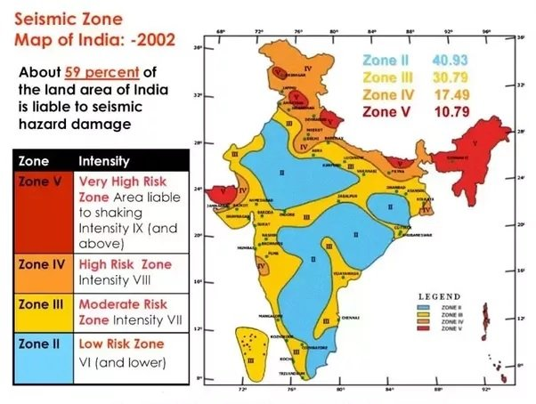
    How are zones designated?

    • Based on seismicity, intensity of earthquakes experienced, and geological and tectonic qualities of a region, countries are divided into several zones.
    • In India, for example, there are four zones, designated Zone II-Zone V. Among these, Zone V is the most hazardous and Zone II the least hazardous.

    Can we predict Earthquakes?

    • Since parameters of the earthquake are unknown, it is near impossible to predict an earthquake.
    • The problem with earthquakes is that they are heavily dependent on the material property, which varies from place to place.
    • If there are elastic waves propagating through a material, there are two kinds of waves — the primary wave which reaches first, and the second one called the secondary wave, which is more destructive.
    • If it is known that the amount of energy released is extremely high, trains and power grids can be shut down and the damage minimised.
    • This has worked in some locations, but not on a large commercial basis.

    Successful attempts made so far

    • The most successful early warning systems are in Japan.
    • They have several hundreds of thousands recording devices.
    • Responses are sent to a central point where they estimate whether it is large enough to form a tsunami or some other hazard, and precautionary steps are taken.


    UPSC 2023 countdown has begun! Get your personal guidance plan now! (Click here)