💥Join UPSC 2027,2028 Mentorship (August Batch) + XFactor Notes & Microthemes PDF

Subject: History

  • Gupta Era Temple uncovered in UP

    Last week, the Archaeological Survey of India (ASI) discovered remains of an ancient temple dating back to the Gupta period (5th century) in a village in Uttar Pradesh’s Etah district.

    Findings of the excavation

    • The Bilsarh site was declared ‘protected’ in 1928.
    • Every year, the ASI undertakes scrubbing work at the protected sites.
    • This year, the team discovered two decorative pillars close to one another, with human figurines resembling an ancient temple.
    • The stairs of the temple had ‘shankhalipi’ inscriptions, which were deciphered by the archaeologists as saying, ‘Sri Mahendraditya’, the title of Kumaragupta I of the Gupta dynasty.

    You will find tons of PYQs on Gupta Period. Try this recent one:

    Q. With reference to the period of Gupta dynasty in ancient India, the towns Ghantasala, Kadura and Chaula were well known as:

    (a) ports handling foreign trade

    (b) capitals of powerful kingdoms

    (c) places of exquisite stone art and architecture

    (d) important Buddhist pilgrimage centres


    [wpdiscuz-feedback id=”1ct5k7tlw1″ question=”Please leave a feedback on this” opened=”1″]Post your answers here.[/wpdiscuz-feedback]

    Who was Kumaragupta I?

    • Kumaragupta I was an emperor of the Gupta Empire of Ancient India.
    • A son of the Gupta emperor Chandragupta II and queen Dhruvadevi, he seems to have maintained control of his inherited territory, which extended from Gujarat in the west to Bengal region in the east.
    • In the 5th century, Kumaragupta I ruled for 40 years over north-central India.
    • Skandagupta, son and successor of Kumaragupta I is generally considered to be the last of the great Gupta rulers.
    • He assumed the titles of Vikramaditya and Kramaditya.

    What is the Shankhalipi script?

    • Shankhalipi or “shell-script” is a term used by scholars to describe ornate spiral characters assumed to be Brahmi derivatives that look like conch shells or shankhas.
    • They are found in inscriptions across north-central India and date to between the 4th and 8th centuries.
    • Both Shankhalipi and Brahmi are stylised scripts used primarily for names and signatures.
    • The inscriptions consist of a small number of characters, suggesting that the shell inscriptions are names or auspicious symbols or a combination of the two.

    Chronology and meaning

    • The script was discovered in 1836 on a brass trident in Uttarakhand’s Barahat by English scholar James Prinsep, who was the founding editor of the Journal of the Asiatic Society of Bengal.
    • A year later, he came across two more similar scripts at Nagarjuna group of caves in the Barabar Hills near Gaya.
    • Prominent sites with shell inscriptions include the Mundeshwari Temple in Bihar, the Udayagiri Caves in Madhya Pradesh, Mansar in Maharashtra and some of the cave sites of Gujarat and Maharashtra.
    • In fact, shell inscriptions are also reported in Indonesia’s Java and Borneo.
    • Scholars have tried to decipher shell script but have not been successful.

    UPSC 2022 countdown has begun! Get your personal guidance plan now! (Click here)


    Back2Basics: Gupta Empire

    • The Gupta Empire was an ancient Indian empire which existed from the early 4th century CE to late 6th century CE.
    • This period is considered as the Golden Age of India by historians.
    • The ruling dynasty of the empire was founded by the king Sri Gupta; the most notable rulers of the dynasty were Chandragupta I, Samudragupta, and Chandragupta II alias Vikramaditya.
    • The 5th-century CE Sanskrit poet Kalidasa credits the Guptas with having conquered about twenty-one kingdoms, both in and outside India, including the kingdoms of Parasikas, the Hunas, the Kambojas, tribes located in the west and east Oxus valleys, the Kinnaras, Kiratas, and others.
    • Many of the literary sources, such as Mahabharata and Ramayana, were canonized during this period.
    • The Gupta period produced scholars such as Kalidasa, Aryabhata, Varahamihira, and Vatsyayana who made great advancements in many academic fields.
  • Thamirabarani Civilization is 3200 years old


    A carbon dating analysis of rice with soil, found in a burial urn at Sivakalai in Thoothukudi district of Tamil Nadu has yielded the date of 1155 BC, indicating that the Thamirabarani civilization dates back to 3,200 years.

    About Thamirabarani River

    • The Thamirabarani or Tamraparni or Porunai is a perennial river that originates from the Agastyarkoodam peak of the Pothigai hills of the Western Ghats.
    • It flows through the Tirunelveli and Thoothukudi districts of the Tamil Nadu state of southern India into the Gulf of Mannar.
    • It was called the Tamraparni River in the pre-classical period, a name it lent to the island of Sri Lanka.
    • The old Tamil name of the river is Porunai.

    Its history

    • Its many name derivations of Tan Porunai include Tampraparani, Tamirabarni, Tamiravaruni.
    • Tan Porunai nathi finds mention by classical Tamil poets in ancient Sangam Tamil literature Purananuru.
    • Recognised as a holy river in Sanskrit literature Puranas, Mahabharata and Ramayana, the river was famed in the Early Pandyan Kingdom for its pearl and conch fisheries and trade.
    • The movement of people, including the faithful, trade merchants and toddy tapers from Tamraparni river to northwestern Sri Lanka led to the shared appellation of the name for the closely connected region.
    • One important historical document on the river is the treatise Tamraparni Mahatmyam.
    • It has many ancient temples along its banks. A hamlet known as Appankoil is located on the northern side of the river.

    Significance of the carbon dating

    • This has provided evidence that there was a city civilisation in south India as long back as 3,200 years ago, the later part of the Indus Valley Civilisation.
    • Vicinity to the ancient port of Muziris, now known as Pattanam, in Kerala add another significance to the trade history of this site.
    • Now, research would be conducted at Quseir al-Qadim and Pernica Anekke in Egypt, which were once part of the Roman empire, as well as in Khor Rori in Oman, to establish the Tamils’ trade relations with these countries.
    • Potsherds bearing Tamil scripts have been found in these countries.
    • Studies would also be conducted in Southeast Asian countries, such as Indonesia, Thailand, Malaysia and Vietnam, where King Rajendra Chola had established supremacy.

    UPSC 2022 countdown has begun! Get your personal guidance plan now! (Click here)

    Also read

    https://www.civilsdaily.com/news/sangam-era-older-than-previously-thought-finds-study/

  • Saroop of the Sikh Holy Book

    A union minister has received one of the Saroops of the holy Guru Granth Sahib flown in from Afghanistan.

    What is Saroop?

    • Saroop is a physical copy of Sri Guru Granth Sahib, also called Bir in Punjabi.
    • Every Bir has 1,430 pages, which are referred to as Ang. The verses on every page remain the same.
    • The Sikhs consider the Saroop of Guru Granth Sahib a living guru and treat it with utmost respect.
    • They believe that all the 10 Gurus were the same spirit in different bodies, and the Guru Granth Sahib is their eternal physical and spiritual form.

    Compilation of Sri Guru Granth Sahib

    • It was the fifth Sikh master, Guru Arjan Dev, who compiled the first Bir of the Guru Granth Sahib in 1604, and installed it at the Golden Temple in Amritsar.
    • Later, the tenth Sikh master, Guru Gobind Singh, added verses penned by the ninth master, his father Guru Tegh Bahadur, and compiled the Bir for the second and last time.
    • It was in 1708 that Guru Gobind Singh declared the Guru Granth Sahib the living Guru of the Sikhs.
    • Guru Granth Sahib is a compendium of hymns written by six Sikh gurus,15 saints, including Bhagat Kabir, Bhagat Ravidas, Sheikh Farid and Bhagat Namdev, 11 Bhatts (balladeers) and four Sikhs.
    • The verses are composed in 31 ragas.

    What does the act of carrying the saroop on one’s head signify?

    • The installation and transportation of Guru Granth Sahib is governed by a strict code of conduct called rehat maryada.
    • As a mark of respect, the Bir of the Guru Granth Sahib is carried on the head, and the person walks barefoot.
    • Whenever a devout sees the Bir of Guru Granth Sahib passing by, s/he removes her shoes and bows.
    • A ceremonial whisk is waved high over the Guru Granth Sahib either on the move or while reading from it.
    • Gurdwaras have a separate resting place for the Saroop, called ‘Sukh Asan Sthan’ or ‘Sachkhand’ where the Guru rests at night.
    • This takes place at the end of the day when the holy book is ceremoniously shut and rested. In the morning, the saroop is again installed in a ceremony called ‘prakash’.
    • Many tourists specially come to watch the prakash and sukha asan ceremony of the Guru Granth Sahib at the Golden Temple.

    Where are copies of the Guru Granth Sahib published?

    • There was a tradition among Punjabis, both Sikhs and Hindus, to copy the Guru Granth Sahib by hand and produce multiple copies.
    • The Udasi and Nirmla sects also played a role in making handwritten copies of the Birs until the British introduced the printing press.
    • Nowadays, the Shiromani Gurdwara Parbandhak Committee (SGPC) has the sole rights to publish the Birs of the Guru Granth Sahib, and this is done at Amritsar.

    UPSC 2022 countdown has begun! Get your personal guidance plan now! (Click here)

    Try answering this PYQ:

    Consider the following Bhakti Saints:

    1. Dadu Dayal
    2. Guru Nanak
    3. Tyagaraja

    Who among the above was/were preaching when the Lodi dynasty fell and Babur took over? (CSP 2018)

    (a) 1 and 3

    (b) 2 only

    (c) 2 and 3

    (d) 1 and 2


    [wpdiscuz-feedback id=”wfybd1zyy2″ question=”Please leave a feedback on this” opened=”1″]Post your answers here:[/wpdiscuz-feedback]

  • Person in news: Sree Narayana Guru

    The Prime Minister has paid tributes to Sree Narayana Guru on his Jayanti.

    Sree Narayana Guru (1856-1928)

    • Narayana Guru was a philosopher, spiritual leader and social reformer in India.
    • He led a reform movement against the injustice in the caste-ridden society of Kerala in order to promote spiritual enlightenment and social equality.

    His legacy:

    Temple Entry

    • He was in the forefront of the movement for universal temple entry and against the societal ills like the social discrimination of untouchables.
    • He gave the famous slogan “One Caste, One Religion, One God for All”.
    • In 1888, he built a temple dedicated to Lord Shiva at Aruvippuram which was against the caste-based restrictions of the time.
    • In one temple he consecrated at Kalavancode, he kept mirrors instead of idols. This symbolised his message that the divine was within each individual.

    Untouchability

    • The social protest of Vaikom Satyagraha (1924-25) was an agitation by the lower caste against untouchability in Hindu society of Travancore.
    • He taught equality but felt the inequalities should not be exploited to carry out conversions and therefore generate strife in society.

    Philosophy

    • Sree Narayana Guru became one of the greatest proponents and re-evaluators of Advaita Vedanta, the principle of non-duality put forward by Adi Shankara.

    Answer this PYQ:

    Q.Which one of the following pairs does not form part of the six systems of Indian Philosophy?

    (a) Mimamsa and Vedanta

    (b) Nyaya and Vaisheshika

    (c) Lokayata and Kapalika

    (d) Sankhya and Yoga


    [wpdiscuz-feedback id=”k8wz5imcou” question=”Please leave a feedback on this” opened=”1″]Post your answers here.[/wpdiscuz-feedback]

    UPSC 2022 countdown has begun! Get your personal guidance plan now! (Click here)

  • Dholavira gets into UNESCO World Heritage list

    The Harappan city of Dholavira, in present-day Gujarat, has been named the 40th Indian site on UNESCO’s World Heritage list.

    Dholavira site

    • The IVC acropolis is located on a hillock near present-day Dholavira village in Kutch district, from which it gets its name.
    • It was discovered in 1968 by archaeologist Jagat Pati Joshi.
    • The site’s excavation between 1990 and 2005 under the supervision of archaeologist Ravindra Singh Bisht uncovered the ancient commercial city.

    Key features

    • It is one of the very few well preserved urban settlements in South Asia dating from the 3rd to mid-2nd millennium BCE.
    • It was located in the island of Khadir which was strategic to harness different mineral and raw material sources (copper, shell, agate-carnelian, steatite, lead, banded limestone, among others).
    • It facilitated internal as well as external trade to the Magan (modern Oman peninsula) and Mesopotamian regions.
    • One finds the origin of the Buddhist Stupas in memorials in Dholavira.

    A gem in the IVC acropolis

    • After Mohen-jo-Daro, Ganweriwala and Harappa in Pakistan and Rakhigarhi in Haryana of India, Dholavira is the fifth largest metropolis of IVC.
    • The site has a fortified citadel, a middle town and a lower town with walls made of sandstone or limestone instead of mud bricks in many other Harappan sites.
    • While unlike graves at other IVC sites, no mortal remains of humans have been discovered at Dholavira.

    Its architecture

    • The city demonstrates its multifaceted achievements in terms of urban planning, construction techniques, water management, social governance and development, art, manufacturing, trading, and belief system.
    • The property comprises two parts:
    1. A walled city: Consists of a fortified Castle with attached fortified Bailey and Ceremonial Ground, and a fortified Middle Town and a Lower Town
    2. A cemetery to the west of the city

    Trade and commercial activities

    • Remains of a copper smelter indicate of Harappans, who lived in Dholavira, knew metallurgy.
    • It is believed that traders of Dholavira used to source copper ore from present-day Rajasthan and Oman and UAE and export finished products.
    • It was also a hub of manufacturing jewellery made of shells and semi-precious stones, like agate and used to export timber.
    • Such beads peculiar to the Harappan workmanship have been found in the royal graves of Mesopotamia, indicating Dholavira used to trade with the Mesopotamians.

    Famous for water conservation

    • The expansive water management system designed to store every drop of water available shows the ingenuity of the people to survive against the rapid geo-climatic transformations.
    • Water diverted from seasonal streams, scanty precipitation and available ground was sourced, stored, in large stone-cut reservoirs which are extant along the eastern and southern fortification.
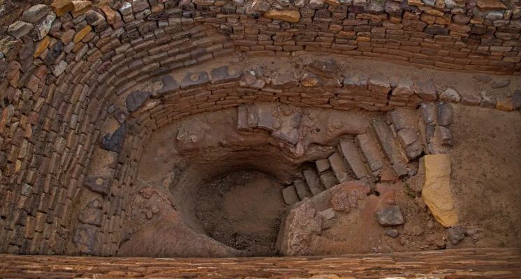
    • To further access water, few rock-cut wells, which date as one of the oldest examples, are evident in different parts of the city, the most impressive one being located in the citadel.
    • Such elaborate water conservation methods of Dholavira is unique and measures as one of the most efficient systems of the ancient world.

    Causes for its decline

    • Harappans, who were maritime people, lost a huge market, affecting the local mining, manufacturing, marketing and export businesses once Mesopotamia fell.
    • From 2000 BC, Dholavira entered a phase of severe aridity due to climate change and rivers like Saraswati drying up.
    • Because of a drought-like situation, people started migrating toward the Ganges valley or towards south Gujarat and further beyond in Maharashtra.
    • In those times the Great Rann of Kutch, which surrounds the Khadir island on which Dholavira is located, used to be navigable, but the sea receded gradually and the Rann became a mudflat.

    Other Harappan sites in Gujarat

    • Before Dholavira was excavated, Lothal, in Saragwala village on the bank of Sabarmati in Dholka taluka of Ahmedabad district, was the most prominent site of IVC in Gujarat.
    • It was excavated between 1955 and 1960 and was discovered to be an important port city of the ancient civilisation, with structures made of mud bricks.
    • From a graveyard in Lothal, 21 human skeletons were found. Foundries for making copperware were also discovered. Ornaments made of semi-precious stones, gold etc. were also found from the site.
    • Besides Lothal, Rangpur on the bank of Bhadar river in Surendranagar district was the first Harappan site in the state to be excavated.
    • Rojdi in Rajkot district, Prabhas near Veraval in Gir Somnath district, Lakhabaval in Jamnagar, and Deshalpar in Bhuj taluka of Kutch are among other Harappan sites in the state.

    Answer this PYQ in the comment box:

    Q.Which one of the following is not a Harappan site? (CSP 2019)

    (a) Chanhudaro

    (b) Kot Diji

    (c) Sohgaura

    (d) Desalpur

    Also read:

    Telangana’s Rudreswara Temple inscribed as a World Heritage Site

  • Telangana’s Rudreswara Temple inscribed as a World Heritage Site

    India’s nomination of Rudreswara Temple, (also known as the Ramappa Temple) at Palampet, Mulugu district, near Warangal in the state of Telangana has been inscribed on UNESCO’s World Heritage list. This would be the 39th site in India.

    Also read:

    [pib] Declaration of World Heritage Sites by UNESCO                 

    Rudreswara Temple

    • The Rudreswara temple was constructed in 1213 AD during the reign of the Kakatiya Empire by Recharla Rudra, a general of Kakatiya king Ganapati Deva.
    • It is also known as the Ramappa temple, after the sculptor who executed the work in the temple for 40 years.
    • The main temple is flanked by the collapsed structures of the Kateshwarayya and Kameshwarayya temples in Palampet, about 220 km from Hyderabad.
    • An inscription dates the temple to 1135 Samvat-Saka on the eighth day of Magha (January 12, 1214).

    Its architecture

    • The temple, known for its exquisite craftsmanship and delicate relief work, is a savvy blend of technical know-how and materials of its time.
    • The foundation is built with the “sandbox technique”, the flooring is granite, and the pillars are basalt.
    • The lower part of the temple is red sandstone while the white gopuram is built with light bricks that reportedly float on water.
    • The temple complexes of Kakatiyas have a distinct style, technology, and decoration exhibiting the influence of the Kakatiyan sculptor.
    • The temple stands on a 6 feet high star-shaped platform with walls, pillars, and ceilings adorned with intricate carvings that attest to the unique skill of the Kakatiyan sculptors.
    • European merchants and travelers were mesmerized by the beauty of the temple and one such traveler had remarked that the temple was the “brightest star in the galaxy of medieval temples of the Deccan”.

    Surviving through ages

    • According to the temple priest, some of the iconography on the temple was damaged during the invasion of Malik Kafur in 1310.
    • Treasure hunters vandalized the rest
    • But the biggest test for the temple was an earthquake in the 17th century (one of the biggest was that of 7.7-8.2-magnitude on June 16, 1819).

    Answer this PYQ in the comment box:

    Q.Which one of the following was a very important seaport in the Kakatiya kingdom? (CSP 2017)

    (a) Kakinada

    (b) Motupalli

    (c) Machilipatnam (Masulipatnam)

    (d) Nelluru


    Back2Basics: UNESCO World Heritage Sites

    • A World Heritage Site is a landmark or area, selected by the UN Educational, Scientific and Cultural Organization (UNESCO) for having cultural, historical, scientific, or other forms of significance, which is legally protected by international treaties.
    • The sites are judged to be important for the collective and preservative interests of humanity.
    • To be selected, a WHS must be an already-classified landmark, unique in some respect as a geographically and historically identifiable place having special cultural or physical significance (such as an ancient ruin or historical structure, building, city, complex, desert, forest, island, lake, monument, mountain, or wilderness area).
    • It may signify a remarkable accomplishment of humanity, and serve as evidence of our intellectual history on the planet.
    • The sites are intended for practical conservation for posterity, which otherwise would be subject to risk from human or animal trespassing, unmonitored/uncontrolled/unrestricted access, or threat from local administrative negligence.
    • The list is maintained by the international World Heritage Program administered by the UNESCO World Heritage Committee, composed of 21 “states parties” that are elected by their General Assembly.

    UNESCO World Heritage Committee

    • The World Heritage Committee selects the sites to be listed as UNESCO World Heritage Sites, including the World Heritage List and the List of World Heritage in Danger.
    • It monitors the state of conservation of the World Heritage properties, defines the use of the World Heritage Fund, and allocates financial assistance upon requests from States Parties.
    • It is composed of 21 states parties that are elected by the General Assembly of States Parties for a four-year term.
    • India is NOT a member of this Committee.
  • Festival in news: Harela Festival

    Villagers across Uttarakhand celebrated Harela, a festival of greenery, peace, prosperity and environmental conservation.

    Harela Festival

    • Harela means ‘day of green’ and is celebrated in the month of Shravan (the fifth month of the Hindu lunar calendar) to worship Lord Shiva and Goddess Parvati.
    • People across Uttarakhand, especially the Kumaun region, associate greenery with prosperity.
    • The seeds of five to seven types of crops —  maize, til (sesame), urad (black gram), mustard, oats —  are sown in donas (bowl made of leaves) or ringalare (hill bamboo baskets) nine days before the festival.
    • They are harvested on the ninth day and distributed to neighbours, friends and relatives.
    • The flourish of the crops symbolizes prosperity in the year ahead.
    • People make clay statues of Lord Shiva and Goddess Parvati, known as Dikare, and worship them a day before the festival.
    • Harela is also linked to the Barahnaza system (12 types of crops), a crop diversification technique followed in the region.

    Answer this PYQ in the comment box:

    Q.Consider the following pairs:
    Tradition: State
    1. Chapchar Kut: festival Mizoram
    2. Khongjom Parba ballad: Manipur
    3. Thang Ta dance: Sikkim
    Which of the pairs given above is/are correct?

    (a) 1 only
    (b) 1 and 2
    (c) 3 only
    (d) 2 and 3

  • Places in news: Kesaria Buddhist Stupa

    The world-famous Kesaria Buddha stupa in east Champaran district of Bihar is waterlogged following floods in some parts of the district after heavy rainfall in the catchment areas of river Gandak in neighbouring Nepal.

    Kesaria Stupa

    • The Kesaria stupa, located about 110 km from the State capital Patna, has a circumference of almost 400 feet and stands at a height of about 104 feet.
    • The first construction of the nationally protected stupa is dated to the 3rd century BCE.
    • It is regarded as the largest Buddhist stupa in the world and has been drawing tourists from across several Buddhist countries.
    • The sputa’s exploration had started in the early 19th century after its discovery led by Colonel Mackenzie in 1814.
    • Later, it was excavated by General Cunningham in 1861-62 and in 1998 an ASI team led by archaeologist K.K. Muhammad had excavated the site properly.
    • The original Kesaria stupa is said to date back to the time of emperor Ashoka (circa 250 BCE) as the remains of an Ashokan pillar was discovered there.

    In the accounts of foreign travellers

    • The stupa mound may even have been inaugurated during the Buddha’s time, as it corresponds in many respects to the description of the stupa erected by the Licchavis of Vaishali to house the alms bowl the Buddha has given them.
    • Interestingly, Chinese travellers Fa-Hien (5th century CE) and Hiuen Tsang (7th century CE), who travelled to India, also mention this stupa and the legend of Buddha and the Licchavis, in their records.
    • While Fa-Hien talks of a pillar erected at the site, Hiuen Tsang mentions the stupa itself.

    Try answering this question from CS Mains 2016:

    Q.Early Buddhist Stupa-art, while depicting folk motifs and narratives successfully expounds Buddhist ideals. Elucidate.

  • National Maritime Heritage Complex

    In order to showcase the maritime heritage and history of India, a National Maritime Heritage Complex (NMHC) will be developed in the Lothal region of Gujarat.

    National Maritime Heritage Complex

    • It is to note that the National Maritime Heritage Complex will be made within the ASI site of Lothal that is located 80 km away from Ahmedabad in Gujarat.
    • The project, once completed, will be made an international tourist destination in India where people from across the countries can take a look at the maritime heritage of India from ancient to modern times.
    • The government is aiming to showcase this via an edutainment approach where the latest technology would be adopted to spread awareness.
    • The development will be done in an area expanding 400 acres.
    • The complex will have many offerings including National Maritime Heritage Museum, Heritage Theme Park, and Light House Museum.

    About Lothal

    • Lothal was one of the southernmost cities of the ancient Indus Valley Civilization located in Gujarat.
    • Construction of the city began around 2200 BCE.
    • According to the ASI, Lothal had the world’s earliest known dock, which connected the city to an ancient course of the Sabarmati river on the trade route between Harappan cities in Sindh and the peninsula of Saurashtra.
    • Lothal was a vital and thriving trade Centre in ancient times, with its trade of beads, gems, and valuable ornaments reaching the far corners of West Asia and Africa.
    • The techniques and tools they pioneered for bead-making and in metallurgy have stood the test of time for over 4000 years.
    • The Lothal site has been nominated as a UNESCO World Heritage Site, and its application is pending on the tentative list of UNESCO.

    Answer this question from CSP 2019 in the comment box:

    Q. Which one of the following is not a Harappan site?

    (a) Chanhudaro

    (b) Kot Diji

    (c) Sohgaura

    (d) Desalpur

  • New geometrical lines discovered in Thar Desert

    Using satellite observations and field visits, two independent researchers from France have identified eight sites around Jaisalmer in the Thar Desert, that show linear features resembling geoglyphs.

    What are geoglyphs?

    • Geoglyphs are large, un-explained geometrical patterns on land usually proposed to be man-made features.
    • The largest concentration of geoglyphs is reported from southern Peru, covering an area of about 1,000 square km.
    • A new paper published notes that the identified geoglyphs in the Thar Desert cover an area of about 6 square km.

    Boha Geoglyphs in Thar

    • The authors’ main area of interest was Boha, a small village 40 km to the north of Jaisalmer where they noticed a series of concentric and linear features.
    • They named these features Boha geoglyphs and suggested that the features could be at least 150 years old.
    • It is however conceivable that they were built at the beginning of the British colonial period, in the middle of the 19th century.

    How are they patterned?

    • The Boha geoglyphs are clearly manmade as the main unit is a giant spiral, but they have been eroded due to the cars running over the lines lately.
    • So, they are clearly not formed by weathering or another natural phenomenon.”
    • The observed features might have been formed naturally, but degraded over time due to both natural and human-related causes.

    Degraded over time

    • The rocky terrain is home to a typical weathering feature, especially over the iron-rich sandstone and shale beds.
    • Here, extreme aridity and high temperature lead to slow geochemical translocation of minerals for centuries, such that the heavier minerals like iron and manganese move away from the lighter minerals.
    • This lead to the gradual formation of alternate bands of harder and softer mineral concentrations.
    • With time the areas with softer materials get slowly eroded, while the harder ones stand out, producing the typical concentric or box-like geometric features.