💥Join UPSC 2027,2028 Mentorship (July Batch) + XFactor Notes & Microthemes PDF

Subject: Geography

  • Dam Safety Act 2021

    hydel dam safety

    Central Idea

    • India boasts nearly 6,000 large dams, but concerns loom over the safety of these structures, with approximately 80% of them being over 25 years old and posing safety risks.
    • With numerous large dams and hydropower projects, the Himalayas play a crucial role in meeting India’s energy needs.
    • However, the recent incident of a Glacial Lake Outburst Flood (GLOF) in North Sikkim has raised alarm bells about the safety of these structures.

    Hydropower boom in the Himalayas

    • As of November 2022, the Himalayan states and Union territories, excluding West Bengal, had 81 large hydropower projects (above 25 MW) in operation, with 26 more under construction.
    • An additional 320 large projects are in the planning stages, according to the Central Electricity Authority under the Union Ministry of Power.

    Discussion: Dam Safety in the Himalayas

    • Vulnerability to Natural Hazards: The Himalayas are highly susceptible to natural hazards such as earthquakes, landslides, and GLOFs due to their complex geological and topographical features. These hazards can jeopardize the integrity of dams and reservoirs.
    • High Population Density: The Himalayan region is densely populated, with communities residing downstream of dams and hydropower projects. A dam failure can have devastating consequences on human lives and property.
    • Ecological Sensitivity: The Himalayas are an ecologically fragile region with unique biodiversity. A dam failure can lead to environmental disasters, impacting delicate ecosystems.

    Repercussions

    • Climate Change: The melting of glaciers due to global warming contributes to the formation of glacial lakes. As these lakes grow, the risk of GLOFs increases, putting downstream infrastructure at risk.
    • Snowball Effects: Landslide dams can lead to impounding of lakes, landslide-induced floods, secondary landslides, channel avulsion, and the formation of flood terraces downstream, impacting communities and infrastructure.
    • Delayed Impacts: Run-of-the-river projects, which often bypass large-scale displacement and forest diversion, have been promoted as environmentally friendly. However, their underground components can disturb geology and geohydrology, leading to indirect displacement and environmental impacts.
    • Aging Infrastructure: Many dams and hydropower projects in the Himalayas are aging, with approximately 80% of them over 25 years old. Proper maintenance and monitoring are essential to ensure their safety.

    Dam Safety Act, 2021 and its Provisions

    • The DSA was introduced in response to dam failures caused by deficient surveillance and maintenance.
    • It establishes key responsibilities and requires the formation of national and state-level bodies for its implementation.
    • The Act outlines the following provisions:
    1. National Committee on Dam Safety: Responsible for overseeing dam safety policies and regulations.
    2. National Dam Safety Authority: Tasked with implementing and resolving state-level disputes.
    3. Chairman of the Central Water Commission (CWC): Heads dam safety protocols at the national level.
    4. State Committee on Dam Safety (SCDS) and State Dam Safety Organisation (SDSO): To be established at the state level.

    Challenges in DSA Implementation

    • Inadequate Risk Assessment: Experts argue that the DSA does not encourage risk-based decision-making and lacks transparency incentives.
    • Transparency Concerns: Dam safety should be a public function, with information readily accessible. However, transparency is impeded when government employees and project engineers dominate national and state bodies, potentially compromising objective decision-making.

    Lessons Learned from Recent Incidents

    • Comprehensive Risk Assessment: Dam safety protocols must include comprehensive risk assessments that consider factors such as climate change, geological stability, and the potential for GLOFs. Periodic reviews yield updated inundation maps and rule curves for reservoir capacity.
    • Hazard Profiling Issues: Hazard risk is influenced by climate change, urbanization, and water usage patterns. Periodic reviews should yield updated inundation maps and rule curves for reservoir capacity. Unfortunately, these reviews are often overlooked or findings are not made publicly available.
    • Standardized Safety Evaluation: The DSA mandates comprehensive dam safety evaluations but lacks standardization in how failures are analyzed and reported.
    • Transparent Reporting: Transparency in dam safety is paramount. The DSA should be implemented rigorously, with an emphasis on transparent reporting of dam failures and safety assessments.
    • Community Involvement: Local communities should be actively engaged in dam safety measures. They can provide valuable insights into the environmental and social impacts of such projects.

    Way Forward

    • Early Warning Systems: Establishing advanced early warning systems that can detect GLOFs and other potential hazards is crucial. These systems can save lives and minimize damage.
    • Regular Maintenance: Aging infrastructure must undergo regular maintenance and upgrades to ensure their continued safety and functionality.
    • International Collaboration: Given the transboundary nature of the Himalayan region, international collaboration on dam safety and disaster management is essential. Neighboring countries should work together to mitigate shared risks.
  • Why are Earthquakes so frequent in Afghanistan?

    Afghanistan

    Central Idea

    • On October 15, Afghanistan was struck by a formidable earthquake with a magnitude of 6.3, adding to the woes of a nation still reeling from a series of devastating quakes just days earlier.
    • This recent seismic activity reflects Afghanistan’s turbulent history of earthquakes, often with catastrophic consequences.

    Understanding Earthquakes

    • Tectonic Plate Movement: The Earth’s lithosphere consists of tectonic plates that move due to internal heat energy. Fault lines are formed along the discontinuities where these plates interact.
    • Earthquake Mechanism: Earthquakes occur when these lithospheric plates suddenly slip past one another, releasing energy that propagates as seismic waves. The point where the slip starts is known as the focus or hypocenter, with the epicenter being its surface projection.

    earthquake

    What exactly causes Earthquakes?

    • As we know, the earth’s outermost surface, crust, is fragmented into tectonic plates.
    • The edges of the plates are called plate boundaries, which are made up of faults.
    • The tectonic plates constantly move at a slow pace, sliding past one another and bumping into each other.
    • As the edges of the plates are quite rough, they get stuck with one another while the rest of the plate keeps moving.
    • Earthquake occurs when the plate has moved far enough and the edges unstick on one of the faults.
    • The location below the earth’s surface where the earthquake starts are called the hypocenter, and the location directly above it on the surface of the earth is called the epicentre.

    Afghanistan’s Seismic Vulnerability

    • Tectonic Plate Intersection: Afghanistan’s location atop the convergence of the Indian and Eurasian tectonic plates results in frequent seismic activity.
    • Eurasian Plate: Afghanistan sits on the Eurasian Plate, with the Arabian Plate subducting northward in the west and the Indian Plate doing the same in the east.
    • Complex Geology: The Hindu Kush mountain range and the Pamir Knot add complexity to this geological region, leading to folding, faulting, and earthquakes.
    • Continual Compression: The northward movement of the Indian Plate toward Eurasia causes compression, uplifting the Himalayas, and transmitting tectonic stress. This leads to crustal deformation, faulting, and seismic activity.
    • Active Fault Systems: Afghanistan is intersected by active fault systems like the Chaman Fault and the Main Pamir Thrust, which are prolific sources of earthquakes.

    History of Earthquake Afghanistan

    • October 11 Quakes: In October 2023, a series of powerful earthquakes, including a magnitude 6.3 tremor, wreaked havoc in Herat province, claiming the lives of at least a thousand people.
    • June 2022 Tragedy: A magnitude 6.1 earthquake in Khost and Paktika provinces in June 2022 left over 1,000 casualties.
    • 2015 Catastrophe: A major earthquake in northeastern Afghanistan in 2015 claimed over 200 lives in Afghanistan and northern Pakistan.
    • 2002 Devastation: A 6.1-magnitude earthquake in 2002 resulted in approximately 1,000 casualties in northern Afghanistan.
    • 1998 Disaster: In 1998, northeast Afghanistan experienced a catastrophic earthquake and subsequent tremors, causing the loss of at least 4,500 lives.
  • Southwest Monsoon begins early Withdrawal/Retreat

    monsoon

    Central Idea

    • India Meteorological Department (IMD) has announced withdrawal of the monsoon.

    What is Monsoon Withdrawal/Retreat?

    • In India, retreating monsoon is the withdrawal of south-west monsoon winds from North India.
    • The withdrawal is gradual and takes about three months.
    • With the retreat of the monsoons, the clouds disappear and the sky becomes clear. The day temperature starts falling steeply.
    • Monsoon rains weaken all over India except few southeastern states.
    • It is helpful in Rabi crop cultivation.

    Factors affecting the retreat

    Two predominant factors cause the phenomenon:

    (1) Land topography

    • First, the low mountain range in each region runs from north to south, shielding it from west-bound winds that trigger summer monsoon.
    • After summer, the range aids in the ‘orographic lift’ or rising of east-bound air mass from a lower to higher elevation, forming clouds and resulting in rain.

    (2) Atmospheric convection

    • The second factor is atmospheric convection or vertical movement of air.
    • As the earth is heated by the sun, different surfaces absorb different amounts of energy and convection may occur where the surface heats up very rapidly.
    • As the surface warms, it heats the overlying air, which gradually becomes less dense than the surrounding air and begins to rise.
    • This condition is more favorable from September to February because of the role played by sea surface temperature or water temperature.

    Immediate factors influencing withdrawal

    • The withdrawal of the monsoon is based on meteorological conditions such as-
    1. Anti-cyclonic circulation (dry air that is the opposite of a cyclone)
    2. Absence of rain in the past five days and
    3. Dry weather conditions over the region

    When does it occur?

    • The monsoon withdrawal is a long-drawn process and extends into mid-October, though the IMD considers September 30 to be the final day of the season over India.
    • The rain after that is categorised as “post-monsoon” rainfall.
  • Places in news: Gurez Valley

    gurez valley

    Central Idea

    • The high-altitude passes within the Gurez valley, located in northern Kashmir, are now linked to the Mushkoh valley in the Drass Sector of Kargil, Ladakh. This region was a significant site during the 1999 war.
    • The newly established 130-kilometer road has been opened to tourists, and one of its highest passes, Kaobal Gali, situated at an elevation of 4,166.9 meters in Gurez, serves as the vital link connecting these two valleys.

    About Gurez Valley

    • Found in the Kashmir valley, Gurez is positioned near the Line of Control, which separates it from Pakistan-administered Kashmir’s Astore and Neelum districts.
    • The local inhabitants are primarily ethnic Dards/Shins who speak the Shina language and share similar dress and cultural traditions with their counterparts in Pakistani-administered Gilgit-Baltistan.
    • The Buduaab village within Gurez valley is known for its Zumba yak, a smaller breed compared to other yaks.
    • Gurez valley played a significant role in the Kargil war.
    • It is closely situated to the Line of Control (LoC), with the Kishanganga river delineating the border in multiple areas.
    • Unique to the Gurez valley is the presence of villages constructed entirely of log houses, devoid of modern urban construction materials.
    • The region boasts diverse fauna and wildlife, including species such as the Himalayan brown bear, snow leopard, ibex, musk deer, and marmots.
    • With approximately 38,000 inhabitants, the Gurez valley has already welcomed an impressive 50,000 tourists this year.

    Back2Basisc: Mushkoh Valley

    • Located in Dras, Ladakh, the Mushkoh valley is also renowned as the “valley of wild tulips.”
    • The valley gained notoriety due to the fierce battle at Tiger Hill during a conflict between India and Pakistan, resulting in numerous casualties on both sides.
    • Mushkoh valley’s meadows are adorned with vibrant wild tulip flowers, and it is home to the endangered Himalayan yew.
  • Assistance to States during Natural Disasters: How It Works

    Central Idea

    • In the wake of natural disasters, states often request assistance from the central government.
    • Himachal Pradesh CM recently requested for a special disaster relief package and urged the designation of the calamity as a ‘national disaster.’

    Natural Disaster Mitigation in States

    • Legal Framework: The 2005 Disaster Management Act provides the legal framework for addressing disasters, whether natural or man-made.
    • Defining disaster: It defines a “disaster” as an event causing substantial loss of life, human suffering, property damage, or environmental degradation beyond the community’s coping capacity.
    • National Disaster Management Authority (NDMA): The Act established the NDMA, headed by the Prime Minister, and State Disaster Management Authorities (SDMAs) led by Chief Ministers. These bodies, along with district-level authorities, form an integrated disaster management setup in India.
    • National Disaster Response Force (NDRF): The Act led to the creation of the NDRF, comprising several battalions or teams responsible for on-ground relief and rescue operations in various states.

    Understanding the National Disaster Relief Fund (NDRF)

    • Mention in the Act: The NDRF is referenced in the 2005 Disaster Management Act and plays a crucial role in providing disaster relief.
    • State Disaster Relief Funds (SDRFs): States have their own SDRFs, which are the primary funds available for responding to notified disasters. The Central Government contributes 75% to SDRFs in general states and 90% in northeastern and Himalayan states.
    • Utilization of SDRFs: SDRFs are allocated for immediate relief efforts following notified calamities, including cyclones, droughts, earthquakes, fires, floods, tsunamis, and more.
    • Central Assistance: In the event of a severe calamity where state SDRF funds are insufficient, additional central assistance can be provided by the National Disaster Response Fund (NDRF).

    Who determines a Severe Calamity?

    • Procedure: States follow a specific procedure to classify a calamity as “severe.” This involves submitting a memorandum detailing sector-wise damage and fund requirements. An inter-ministerial central team assesses the damage on-site.
    • Committee Approval: Specific committees review these assessments and submit reports. A High-Level Committee must approve the immediate relief amount to be released from the NDRF.
    • Criteria: The classification of a calamity as “severe” considers factors such as intensity, magnitude, assistance needs, and more.

    Additional Funds for Disaster Mitigation

    • Funds Allocation: Funds for NDRF and SDRFs, allocated for preparedness, mitigation, and reconstruction, are part of budgetary allocations.
    • Financing mechanism: The 15th Finance Commission introduced a new methodology for state-wise allocations, considering factors like past expenditure, risk exposure, hazard, and vulnerability.
    • Utilization: NDRF and SDRF funds are released in two equal instalments, typically with requirements like Utilization Certificates. However, in urgent situations, these requirements can be waived.
    • State Disaster Mitigation Fund (SDMF): This fund supports activities such as forest restoration and public awareness. It received an allocation of Rs 32,030 crore from the 15th Finance Commission.
    • National Disaster Mitigation Fund (NDMF): The NDMF, amounting to Rs 13,693 crore, is dedicated to national disaster mitigation efforts.
  • Deadly Earthquake strikes Morocco

    morocco earthquake

    Central Idea

    • A devastating earthquake struck Morocco, resulting in significant casualties and damage.

    Details of the Moroccan Earthquake

    • Shallow Epicenter: The quake’s epicentre was near the town of Ighil, approximately 70 km southwest of Marrakech. It was considered fairly shallow, with varying depth estimates.
    • Higher Energy: Shallow earthquakes are typically more dangerous as they carry more energy, making them more destructive compared to deeper quakes.

    Major Causes

    • Tectonic Convergence: The earthquake resulted from the northward convergence of the African plate with the Eurasian plate along a complex plate boundary.
    • Faulting: The USGS attributed the quake to oblique-reverse faulting at a shallow depth within the Moroccan High Atlas Mountain range.
    • Fault Classification: Oblique-slip faults exhibit characteristics of both dip-slip and strike-slip faults, occurring in areas of compression where tectonic plates converge.

    Why discuss this?

    • Low Seismicity: Earthquakes are uncommon in North Africa, with low seismicity rates along the northern margin of the continent.
    • Historic Strength: This earthquake was the strongest ever recorded in the mountainous region, catching Morocco unprepared for such an event.
    • Construction Vulnerabilities: Many Moroccan buildings, especially in rural areas and older cities, are not constructed to withstand strong tremors.

    What is an Earthquake?

    • An earthquake is an intense shaking of the ground caused by movement under the earth’s surface.
    • It happens when two blocks of the earth suddenly slip past one another.
    • This releases stored-up ‘elastic strain’ energy in the form of seismic waves, which spreads through the earth and cause the shaking of the ground.

    morocco earthquake

    What exactly causes Earthquakes?

    • As we know, the earth’s outermost surface, crust, is fragmented into tectonic plates.
    • The edges of the plates are called plate boundaries, which are made up of faults.
    • The tectonic plates constantly move at a slow pace, sliding past one another and bumping into each other.
    • As the edges of the plates are quite rough, they get stuck with one another while the rest of the plate keeps moving.
    • Earthquake occurs when the plate has moved far enough and the edges unstick on one of the faults.
    • The location below the earth’s surface where the earthquake starts are called the hypocenter, and the location directly above it on the surface of the earth is called the epicentre.
  • Why Zoning of Flood Plains is important?

    flood plain

    Central Idea

    • Punjab has been grappling with severe floods for over a month, predominantly affecting villages along rivers like Sutlej, Beas, Ravi, and Ghaggar.
    • These areas, known for their fertile flood plains, have been hit the hardest due to floods exacerbated by encroachments and construction.

    Flood Plains and their Significance

    • Flood plains adjacent to rivers serve as natural defences against inland flooding. Maintained without concrete encroachments, they absorb excess water, safeguarding other regions.
    • Properly managed flood plains also aid in recharging groundwater levels and maintaining the water table.

    What is Zoning of Flood Plains?

    • Zoning of flood plains refers to the practice of categorizing and regulating different areas within flood-prone regions based on their vulnerability to flooding and the intensity of flood events.
    • This aims to manage land use and construction activities in these areas to minimize the risks associated with flooding, protect communities and infrastructure, and maintain the natural functions of flood plains.
    • It involves designating specific zones within flood-prone regions and establishing regulations and guidelines for development, construction, and land use in each zone.

    Current Scenario: No Zoning in Punjab

    • National Green Tribunal (NGT): NGT guidelines state that construction should not occur within 500 meters of a river’s central lining.
    • Punjab’s Lag: Despite NGT’s directives and the need for floodplain zoning, Punjab has yet to initiate the process. Encroachments persist, putting riverside villages at perpetual risk.

    Impact of Inaction: People and Ecosystems Affected

    • Risk to People and Property: Unregulated construction leads to increased flood risks further inland, causing greater harm during floods.
    • Environmental Impact: Concretization of flood plains delays water drainage and affects soil fertility and quality.

    Flood Prone Districts and National Issue

    • Districts at Risk: Many districts including Ropar, Ludhiana, Ferozepur, Patiala, and more fall within flood plains, magnifying the need for preparedness.
    • Nationwide Challenge: While only four states have adopted flood plain zoning in principle, implementation has been insufficient. Even those that adopted zoning have not effectively delineated and demarcated flood plains.

    Activists’ Advocacy

    • Activists’ Concerns: Environmental activists and NGOs in Punjab have been advocating for flood plain zoning to mitigate risks.
    • Urgent Implementation: Immediate initiation and completion of flood plain zoning are crucial to safeguard lives, property, and ecosystems from devastating floods.

    Conclusion

    • The recent floods in Punjab underline the urgency of flood plain zoning to avert catastrophe.
    • By adopting effective zoning measures, the state can shield its citizens and environment from the damaging impacts of unchecked construction and flooding.
    • It is imperative that Punjab takes swift action to implement flood plain zoning and thereby protect its vulnerable regions from the perpetual threat of floods.
  • In news: International Atomic Energy Agency (IAEA)

    Central Idea

    • Japan has begun discharging treated radioactive wastewater from the disabled Fukushima Daiichi Nuclear Power Station into the Pacific Ocean in a plan endorsed by the International Atomic Energy Agency (IAEA).

    International Atomic Energy Agency (IAEA)

    • IAEA is an international organization that plays a pivotal role in promoting the peaceful use of nuclear energy while preventing the proliferation of nuclear weapons.
    • It was established in 1957 as an autonomous agency under the UN is headquartered in Vienna, Austria.
    • It plays a crucial role in safeguarding the principles outlined in the Nuclear Non-Proliferation Treaty (NPT) of 1970.
    • Despite its independent treaty, the IAEA remains accountable to both the UN General Assembly and the United Nations Security Council (UNSC).

    What does it do?

    • Promotion of Peaceful Nuclear Energy: Established amidst the Cold War’s geopolitical tension, the IAEA’s core mission centers on promoting the constructive application of nuclear energy.
    • Prevention of Military Use: The agency’s fundamental role is to prevent the diversion of nuclear programs for military intentions, ensuring compliance with international agreements.

    IAEA’s Tri-fold Missions

    • Peaceful Utilization: Fostering member states’ constructive adoption of nuclear energy for peaceful purposes constitutes a pivotal aspect of IAEA’s mission.
    • Safeguarding Measures: A cornerstone role of the IAEA involves implementing measures to verify the non-military use of nuclear energy, particularly through assessing declared nuclear activities and materials.
    • Nuclear Safety: The IAEA takes an active stance in advocating stringent standards of nuclear safety to prevent accidents and ensure public and environmental protection.

    Significant feature: IAEA’s Safeguards

    • Purpose of Safeguards: IAEA’s safeguards are mechanisms designed to affirm that a nation adheres to its international commitment against exploiting nuclear programs for weaponry purposes.
    • Verification Approach: Safeguards are founded on the meticulous examination of a state’s reported nuclear materials and activities, evaluating their accuracy and completeness.
    • Varied Verification Measures: The agency employs a range of verification tools, including on-site inspections, visits, and ongoing monitoring, ensuring rigorous oversight.

    Dual Dimensions of Safeguards

    • Declared Nuclear Material Verification: Through the inspection of reported nuclear materials and activities, IAEA ensures that a state remains transparent in its nuclear endeavors.
    • Non-Diversion Assurance: A significant facet is the assurance of the absence of undeclared nuclear materials or activities, thereby averting any unauthorized deviation from peaceful usage.
  • Fujiwhara Effect: When cyclones dance

    fujiwhara

    Central Idea

    • In the ever-changing tapestry of Earth’s climate, the Fujiwhara effect has emerged as a captivating and consequential phenomenon.
    • With cyclones intensifying due to global warming, this intricate ‘dance’ between cyclones is garnering attention.

    Why in news?

    • Surprising Weather: Recently, a storm named Hurricane Hilary brought a tropical twist to the US west coast. It’s part of a series of odd weather happenings there.
    • Wet Weather: Earlier this year, California had an unexpected rainy season with lots of wet storms, called ‘atmospheric rivers.’
    • Fujiwhara Show: During one of these storms, something special occurred—an effect named after a scientist. Let’s dive into the details.

    Decoding the Fujiwhara Effect

    • Cyclone Waltz: Imagine two cyclones (or big storms) spinning in the same direction. When they get close, they begin a kind of dance around a common center.
    • Outcome of the Dance: Depending on the strength of the cyclones, they might merge, spin together, or one might absorb the other.
    • Super Cyclone: Rarely, if both cyclones are super strong, they can become one mega cyclone that causes big trouble.

    Historical Context and Impact

    • Origins and Discovery: The Fujiwhara effect got its name from a Japanese scientist who first talked about it in 1921. It was seen happening for real in 1964.
    • Effects Unleashed: This unusual dance can be fierce. It has caused strong winds, broken windows, and power problems in some areas.
    • Guessing Game: The Fujiwhara effect is tricky for weather experts. It’s hard to predict what will happen when two cyclones dance together.

    Climate Change Connection

    • More Frequent Moves: The Fujiwhara effect is showing up more often now. Experts believe it’s because our world is getting hotter and ocean waters are warming up.
    • Hotter Waters: Because of global warming, storms are getting stronger. For instance, in Taiwan, typhoons have become 35% stronger since 1977 due to warmer oceans.

    Implications

    • Nature’s Symphony: The Fujiwhara effect is like a nature’s concert, showing us how everything is connected in our climate.
    • Future Twist: As storms get more powerful, the Fujiwhara effect could become even more important and harder to understand.
    • Planet’s Dance: The Fujiwhara effect teaches us about our planet’s rhythm and how important it is to take care of our home.
  • Himachal Floods: A man-made disaster?

    himachal

    Central Idea

    • Himachal Pradesh has experienced devastating flash floods during the recent monsoon season, resulting in a significant loss of lives and assets.
    • This article explores the factors contributing to the floods, including climate change and anthropogenic actions, and raises questions about the current development model’s sustainability.

    Reasons for amplified Flood Impacts

    [A] Climate Change and Floods

    • IPCC’s Warning: The IPCC VI report predicts that the Himalayas and coastal regions of India will be the hardest hit by climate change. Increased precipitation in shorter periods is evident in the Himalayas, leading to heavy rains and floods.
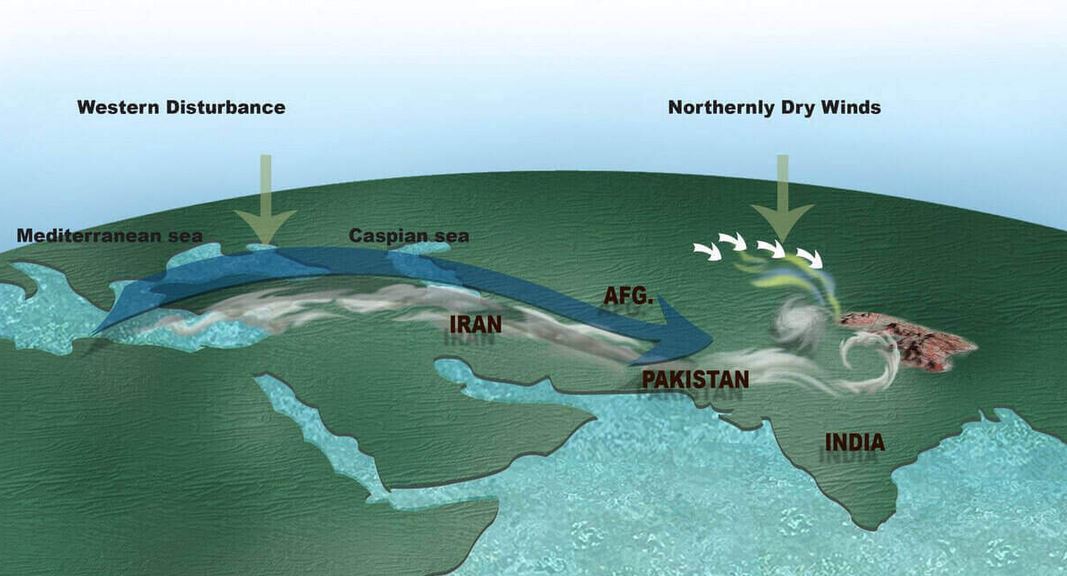
    • Abnormal Rainfall: Normal rainfall is expected to be between 720mm and 750mm, but instances of exceeding 888mm in 2010 and 926.9mm in 2018 have been observed. The current precipitation has been a result of the combined effect of the southwest monsoon and western disturbances.

    [B] Impact of Development Model

    • Dr. Parmar Model: Himachal Pradesh’s development model, initiated in 1971, transformed the state into a model of development for mountain regions. It focused on land reforms, social welfare investments, and human resource development.
    • Shift in Development: Liberalization brought demands for fiscal reforms, forcing the state to generate its own resources. Exploitation of natural resources such as forests, water, tourism, and cement production became the focus of development efforts.
    • Hydropower Projects: Dominant focus on hydropower projects led to uncontrolled construction, transforming mountain rivers into streams, and causing ecological damage.
    • Tourism Expansion: Road expansion for tourism promotion resulted in bypassing geological studies, leading to landslides and destruction during rainfall.
    • Cement Plants: Establishment of massive cement plants altered the landscape, reducing the land’s water absorption capacity and contributing to flash floods.
    • Changing Crop Patterns: Shift from traditional cereal farming to cash crops increased the demand for hastily constructed roads without proper drainage, leading to rapid swelling of rivers during rainfall.

    Way Forward

    • Commission of Inquiry: Instituting a Commission of Inquiry involving major stakeholders can address policy framework failures and project aspects.
    • Empowering Local Communities: A new architecture is needed to empower local communities over their assets. Insuring assets and involving local communities as custodians can expedite rebuilding efforts.
    • Sustainable Infrastructure: With climate change as a reality, infrastructure planning should adapt to avert disasters and mitigate the impacts of heavy rainfall.

    Conclusion

    • The flash floods in Himachal Pradesh demonstrate the consequences of both climate change and human-induced development.
    • It calls for a comprehensive approach that considers sustainable development practices, empowers local communities, and prioritizes environmental conservation to protect lives and assets in the region.