💥Join UPSC 2027,2028 Mentorship (July Batch) + XFactor Notes & Microthemes PDF

Subject: Conservation & Mitigation

1. Conservation Progs.
2. Worldwide initiatives
3. Mitigation Strategies
4. Conventions and Protocols

  • [pib] Schedule IV of the Wild Life (Protection) Act, 1972

    Why in the News?

    • Many individuals, organizations, and zoos in India currently possess living specimens of exotic animal species listed under Schedule IV of the Wild Life (Protection) Act, 1972.
      • These exotic species must be reported and registered as mandated by the Ministry of Environment, Forest and Climate Change in the PARIVESH 2.0 Portal.

    Legal Framework for Reporting of Animals in Possession

    • The Living Animal Species (Reporting and Registration) Rules, 2024, were notified under Section 49 M of the Wild Life (Protection) Act via a Gazette Notification on February 28, 2024.
    • Who Must Register: Any person or entity in possession of a living specimen of species listed in Schedule IV of the Wild Life (Protection) Act, 1972.
      • Failure to report and register these species within the stipulated time frame may result in penal actions.

    About Schedule IV of the WPA

    Details
    Protection Level Provides legal protection to species, prohibiting their hunting, capture, or trade. Protection is less stringent compared to Schedules I & II.
    Offenses and Penalties Violations can lead to fines and imprisonment, but penalties are generally less severe than those for species in higher schedules.
    New Amendment (2022) The Wildlife (Protection) Amendment Act, 2022, inserted a new Schedule IV for specimens listed in the CITES Appendices.
    Examples of Species Flamingos, Hares, Falcons, Kingfishers, Magpie, and Horseshoe Crabs.
    Purpose Ensures legal protection to prevent exploitation and population decline of species that are not critically endangered but still need protection.
    General Protection Role Plays an important role in broader conservation efforts, offering safeguards to a wider range of species in India.


    PYQ:

    [2020] If a particular plant species is placed under Schedule VI of The Wildlife Protection Act, 1972, what is the implication?

    (a) A licence in required to cultivate that plant.

    (b) Such a plant cannot be cultivated under any circumstances.

    (c) It is a Genetically Modified crop plant.

    (d) Such a plant is invasive and harmful to the ecosystem.

  • Yaks from China stray into eastern Ladakh

    Why in the News?

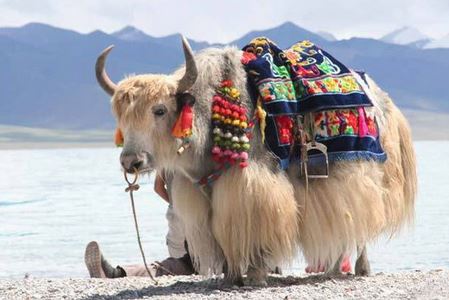
    Around 40 Chinese yaks ventured into Indian Territory in the “Demchok” area of eastern Ladakh and are currently under the control of the local villagers.

    Grazing land issue at LAC:

    • Nomads from both sides traditionally access grazing grounds across the LAC.
    • Indian nomads have been stopped by Chinese soldiers when crossing to the Chinese side.
    • Demchok nomads lost access to Lungkar Valley in 2022 and Nilung Valley in 2017.
    • Loss of these areas has negatively impacted the livelihoods of border residents.
    • China expanded its presence on the Indian side of Charding nala (adjacent to Demchok) since 2020 stand-off.

    About Himalayan Yaks in India:

    Details
    Species Belongs to the Bovini tribe, including bison, buffaloes, and cattle.
    Adaptation Can tolerate extreme cold, down to -40°C; adapted for high altitudes with long, insulating hair.
    Cultural Significance Valued by Himalayan peoples;

    Linked to Tibetan Buddhism legend of Rinpoche.

    Raising Method Traditionally reared under a transhumance system; involves significant hardship.
    Habitat Endemic to the Tibetan Plateau and high-altitude regions.
    Altitude Preference Thrives above 14,000 feet; typically climbs to 20,000 feet and rarely descends below 12,000 feet.
    Yak-Rearing States in India Arunachal Pradesh, Sikkim, Uttarakhand, Himachal Pradesh, Jammu & Kashmir.
    Population Decline 2019 census: 58,000 yaks in India, a 25% drop from 2012; decline due to low remuneration and market.
    Significance Provides crucial nutritional and livelihood security for pastoral nomads in high-altitude regions.
    Threats Climate change causing heat stress; inbreeding due to closed borders limiting genetic diversity.
    Protection Status* – IUCN Red List: Vulnerable
    – CITES: Appendix I
    – Indian Wildlife Act: Schedule I
    Food Status* Approved as a ‘food animal’ by the Food Safety and Standard Authority of India (FSSAI).


    PYQ:

    [2016] What is/are unique about ‘Kharai camel’, a breed found in India?

    1. It is capable of swimming up to three kilometres in seawater.

    2. It survives by grazing on mangroves.

    3. It lives in the wild and cannot be domesticated.

    Select the correct answer using the codes given below:

    (a) 1 and 2 only

    (b) 3 only

    (c) 1 and 3 only

    (d) 1, 2 and 3

  • Banni Grasslands of Kachchh

    Why in the News?

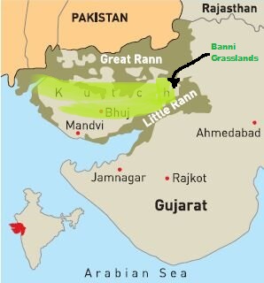
    A study conducted by researchers at Kachchh University assessed the suitability of different areas in Banni for sustainable grassland restoration, with ecological value being the primary criterion.

    Restoration of Banni Grasslands: Highlights of the Study

    Recent Study:

    • Objective: A study conducted by researchers at KSKV Kachchh University assessed the suitability of different areas in Banni for sustainable grassland restoration, with ecological value being the primary criterion.
    • Need for restoration: Originally covering about 3,800 sq. km, the Banni grasslands have shrunk to about 2,600 sq. km.
    • Categories of Restoration Zones: The researchers divided the grassland into five categories based on restoration suitability:
      • Highly Suitable: 937 sq. km (36%)
      • Suitable: 728 sq. km (28%)
      • Moderately Suitable: 714 sq. km (27%)
      • Marginally Suitable: 182 sq. km (7%)
      • Not Suitable: 61 sq. km (2%)
    • Restoration Potential: The “highly suitable” and “suitable” zones, making up nearly two-thirds of the Banni grasslands, can be restored easily by providing adequate water sources.

    About Banni Grasslands:

    • The Banni Grassland is a salt-tolerant ecosystem located in the Kutch district of Gujarat, covering around 3,847 square km.
    • It is said to be Asia’s largest grassland (TOI).
    • The climate is arid and semi-arid, with extremely hot summers (temperatures above 45°C) and mild winters (12°C to 25°C), receiving 300-400 mm of annual rainfall mainly during the monsoon.
    • It is inhabited by pastoral communities like the Maldharis, who rely on livestock grazing (cattle, buffalo, and sheep) for their livelihood.
    • Agriculture is limited due to arid conditions, with some areas used for salt production.
    • Flora: Grasses such as Dichanthium, Sporobolus, and Cenchrus species, with salt-tolerant plants, shrubs, and trees like Acacia and the invasive Prosopis juliflora.
    • Fauna: Indian wolf, hyena, chinkara, Great Indian Bustard, flamingos, and various raptors, reptiles, and invertebrates.

    PYQ:

    [2021] The vegetation of Savannah consists of grassland with scattered small trees, but extensive areas have no trees. The forest development in such areas is generally kept in check by one or more or a combination of some conditions. Which of the following are such conditions?​

    1. Burrowing animals and termites​

    2. Fire​

    3. Grazing herbivores​

    4. Seasonal rainfall​

    5. Soil properties​

    Select the correct answer using the code given below.​

    (a) 1 and 2

    (b) 4 and 5​

    (c) 2, 3 and 4

    (d) 1, 3 and 5​

  • Waggle Dance of Bees

    Why in the News?

    Two scientists have raised concerns about “problematic behaviour” in papers on honeybee communication co-authored by Dr. Mandyam Srinivasan, a highly honoured neuroscientist.

    About Waggle Dance of Bees

    Details
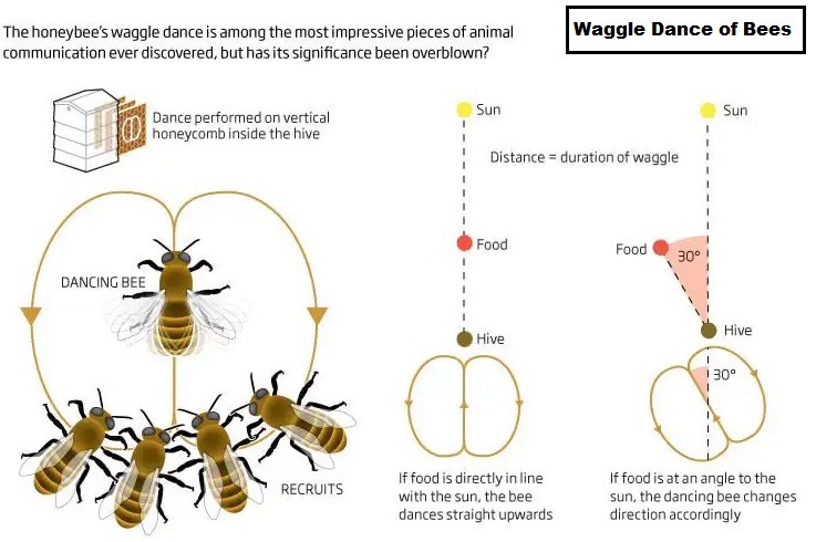
    Purpose Communicates location of food sources to other bees.
    Dance Pattern Figure-eight (8) movement with a waggle run in the middle.
    Direction Indication Angle of waggle run shows direction relative to the sun.
    Distance Indication Duration of waggle run indicates distance to the food source.
    Efficiency Enhances foraging efficiency by guiding bees directly to food sources.
    Environmental Impact Accuracy affected by Sun position, wind, and landscape.
    Scientific Importance Decoded by Nobel laureate Karl von Frisch; an example of advanced insect communication.


    PYQ:

    [2023] Which of the following organisms perform waggle dance for others of their kin to indicate the direction and the distance to a source of their food?

    (a) Butterflies

    (b) Dragonflies

    (c) Honey Bees

    (d) Wasps

  • Illegal mining, encroachments, and deforestation a threat to Aravali as natural green wall   

    Why in the News?

    The Aravalli range is facing severe threats from illegal mining, deforestation, and encroachments which causing environmental degradation.

    About the Aravalli Range:

    • The Aravalli Range is one of the oldest mountain ranges in the world, stretching from Gujarat to Delhi through Rajasthan.
    • It acts as a natural green wall in the northwestern part of India, forming an ecotone zone between the Thar Desert and the Gangetic Plain in a semi-arid environment.
    • The range spans 692 km in length and varies in width from 10 km to 120 km, with over 500 hillocks. The highest peak is Guru Shikhar in Mount Abu, which is 1,722 meters above sea level.
    • Rajasthan contains 80% of the range, while the remaining 20% is shared by Haryana, Delhi, and Gujarat.

    Change in Forest Area and High Rates of Carbon Influx:

    • Reduction of forest cover: The Aravalli range has experienced a significant reduction in forest cover, with a 0.9% decrease from 1999 to 2019. The forest area decreased from 29,915 sq. km in 1999 to 29,210 sq. km in 2019.
    • Increased Human settlement and reduced water bodies: Human settlements in the region increased from 4.5% in 1975 to 13.3% in 2019, while waterbodies initially increased and then began to reduce over time.
    • Expansion of mining activities: Mining activities have expanded, particularly in districts like Jaipur, Sikar, Alwar, Ajmer, Bhilwara, Chittorgarh, and Rajsamand.
    • High rate of carbon influx: The study identified regions in the upper and lower Aravalli range with high positive rates of carbon flux due to high rainfall and protected areas. In contrast, areas near the Thar Desert in the main middle range showed negative rates of carbon flux, indicating a decline in carbon sequestration.

    How Drone Survey Can Help:

    • Use of LiDAR technology:  A comprehensive drone survey using Light Detection and Ranging (LiDAR) technology is recommended to assess the Aravalli region’s surface and objects in 3D dimensions.
      • The LiDAR survey can help identify and mitigate illegal mining activities by providing detailed information on the surface structure which will allow authorities to take prompt enforcement actions.
    • Establishment of Independent Body: The establishment of an independent Aravali Development Authority, including experts from various fields, is suggested to devise and implement strategies for the sustainable preservation of the hill ecosystem.

    Steps taken: 

    • The Indian government has enacted various legal measures to protect the Aravalli Range.
      • In 1992, parts of the hills were designated as Ecologically Sensitive Areas, and in 2003, the central government prohibited mining operations in these regions.
    • The Supreme Court of India further reinforced these protections by banning mining in notified areas of the Aravalli Range in 2004 and extending this ban in 2009 to cover 448 km² across Haryana’s Faridabad, Gurgaon, and Mewat districts.

    Conclusion: Need to engage local communities in conservation efforts and promote sustainable land-use practices. Establish the proposed Aravali Development Authority to coordinate and implement long-term strategies for ecological restoration and biodiversity preservation.

    Mains PYQ:

    Q Briefly mention the alignment of major mountain ranges of the world and explain their impact on local weather conditions, with examples. (UPSC IAS/2021)
  • [pib] Green Tug Transition Program (GTTP)

    Why in the News?

    The Union Minister of Port Shipping and Waterways has launched the standard operating procedures for Green Tug Transition Program (GTTP). 

    What is the Green Tug Transition Program (GTTP)?

    • The GTTP aims to transition conventional fuel-based harbour tugs to greener, more sustainable alternatives. 
    • The program is a part of India’s broader efforts to decarbonize maritime operations and promote environmental sustainability in the maritime sector.
    • The GTTP is also aligned with the ‘Panch Karma Sankalp,’ a strategic framework for enhancing India’s commitment to a greener and more sustainable maritime industry.

    Key Features:

    (1) Decarbonization of Maritime Operations

    • Objective: Replace conventional tugs with green tugs powered by cleaner fuels like battery-electric, hybrid, methanol, and green hydrogen.
    • Impact: Significant reduction in greenhouse gas emissions in Indian ports.

    (2) Phased Implementation

    • Phase 1 (2024-2027): Four Major Ports (Jawaharlal Nehru, Deendayal, Paradip, and V.O. Chidambaranar) will each procure or charter two green tugs.
    • Technology: Initial tugs will be battery-electric with provisions for adopting newer technologies.

    (3) Standardization and Compliance

    • ASTDS-GTTP Standards: By 2040, all tugs in Indian Major Ports will comply with green standards, ensuring an eco-friendly fleet.

    (4) Alignment with National Visions

    • Maritime India Vision 2030: Supports goals like sourcing 60% of port power from renewable energy and reducing carbon emissions by 30% per ton of cargo by 2030.
    • Maritime Amrit Kaal Vision 2047: Aims to reduce greenhouse gas emissions from port vessels by 30% by 2030.

    PYQ:

    [2023] Consider the following pairs:

    Port Well known as
    1. Kamarajar Port First major port in India registered as a company
    2. Mundra Port Largest privately owned port in India
    3. Visakhapatnam Port Largest container port in India

    How many of the above pairs are correctly matched?

    (a) Only one pair
    (b) Only two pairs
    (c) All three pairs
    (d) None of the pairs

  • Why climate change poses an existential threat to Panama Canal?   

    Why in the News?

    The Panama Canal, which links the Atlantic and Pacific Oceans through the Isthmus of Panama, opened to ships 110 years ago. Now, it is facing a serious threat to its existence.

    System of Water Elevators

    • The Panama Canal utilizes a sophisticated lock system that functions as water elevators, allowing ships to navigate the elevation difference between the Atlantic and Pacific Oceans. This system is essential because the two oceans are at different elevations, with the Pacific being slightly higher.

    Operation of the Locks

    1. Ship Enters: A ship approaches the first lock chamber, which is at sea level. The gate opens to allow the ship into the chamber and then closes behind it.
    2. Water Level Adjustment: The valve between the first and second chamber (at a higher elevation) is opened, allowing water to flow into the first chamber from the adjacent higher chamber. This increases the water level in the first chamber.
    3. Transition: Once the water levels between the two chambers are equalized, the gate between them opens, allowing the ship to move into the next chamber. This process is repeated until the ship reaches the desired elevation of 85 feet at Gatun Lake.
    4. Lowering: The reverse process occurs when lowering ships back to sea level at the other end of the canal.

    Note: Each passage requires over 50 million gallons (approximately 200 million liters) of freshwater, primarily sourced from Lake Gatun, which is vital for the canal’s operation.

    Threat of Climate Change

    • Recent droughts have led to significantly lower water levels in Lake Gatun because droughts were exacerbated by climate change and the El Niño phenomenon, which have led to significantly reduced water levels in the lake.
    • In 2023, rainfall was 43% lower than average, making it one of the driest years on record for the region.  which reduced the number of ships able to transit the canal.
    • In December, traffic dropped to as low as 22 ships per day, highlighting the vulnerability of the canal to climatic variations.

    Contentious Solution

    • Proposed Dam: This $1.6 billion project aims to create an additional water source for the canal on the Rio Indio, potentially securing water availability for the next 50 years. However, it has sparked controversy due to its social implications.
      • Displacement Issues: The dam would flood the homes of approximately 2,000 residents, predominantly from lower socio-economic backgrounds, forcing them to relocate and lose their livelihoods. This raises significant ethical concerns regarding the balance between infrastructure needs and the rights of affected communities

    Conclusion:

    Before proceeding with the Rio Indio dam project, engage in thorough consultations with the affected communities, ensuring their voices are heard in the decision-making process. Need to develop a fair compensation and resettlement plan that prioritizes the socio-economic well-being of displaced residents, offering alternative livelihoods and housing options to minimize the negative impact on vulnerable populations.

    Do you know about another elevation-based canal system? 

    1. Kiel Canal (Germany): The Kiel Canal features locks that raise and lower vessels to navigate the elevation differences between the North Sea and the Baltic Sea. It is one of the busiest artificial waterways in the world.
    2. Welland Canal (Canada): This canal connects Lake Ontario and Lake Erie and includes a series of locks that lift ships approximately 43 meters (141 feet) to bypass Niagara Falls. It is an essential part of the Great Lakes shipping route.

    Trade from Panama Canal: 

    • The Panama Canal moves roughly $270 billion worth of cargo annually, which is the trade route taken by 40% of all U.S. container traffic alone. It handles about 5% of all global maritime trade.

    Mains PYQ:

    Mention the significance of straits and isthmus in international trade. (UPSC IAS/2022)

  • How can traffic which causes air pollution be controlled?    

    Why in the News?

    India has 83 of the world’s 100 most polluted cities. Air pollution caused 2.1 million deaths, with 99% breathing air below WHO standards.

    Share of Road Transport in India’s CO2 Emissions as per the International Energy Associates

    • Road transport is responsible for approximately 12% of India’s total CO2 emissions. Within this sector, heavy vehicles are a significant contributor to particulate matter (PM2.5) emissions, which are particularly harmful due to their ability to penetrate deep into the lungs and enter the bloodstream. 
    • Studies indicate that heavy vehicles contribute to about 60-70% of total vehicular PM emissions and 40-50% of total Nitrogen Oxide (NOx) emissions in urban areas. This highlights the critical role that road transport plays in India’s overall air pollution problem.

    Why has the vehicular scrapping policy not been effective in States like Karnataka and Maharashtra?

    • Insufficient Scrapping Facilities: Both states have a limited number of registered vehicle scrapping facilities (RVSFs). For instance, Karnataka has only two authorized RVSFs located in Devanahalli and Koratagere, which are unable to handle the volume of vehicles eligible for scrapping.
    • Voluntary Compliance: The policy’s reliance on voluntary participation has resulted in low engagement from vehicle owners. For example, the policy targets around 20 lakh vehicles for scrapping, but without mandatory compliance, many older, polluting vehicles continue to operate on the roads
    • Lack of Awareness and Less Incentives: There is a lack of awareness regarding the benefits of scrapping old vehicles among the public. Although the policy offers incentives, such as tax relief for scrapping vehicles may not be sufficient to encourage widespread participation.
    • Bureaucratic delays: The implementation of the scrapping policy has faced bureaucratic delays and inconsistencies. In Maharashtra, despite announcing incentives for scrapping old vehicles, the actual impact has been limited due to slow bureaucratic processes and a lack of effective enforcement.

    Steps taken: 

    The Bureau of Energy Efficiency (BEE) has taken several significant steps towards enhancing fuel efficiency and reducing carbon emissions in the transport sector through the implementation of the Corporate Average Fuel Economy (CAFE) norms. 

    • Introduction of CAFE Norms: The BEE has proposed the CAFE III and CAFE IV norms, which aim to set stringent targets for carbon emissions from passenger vehicles.
      • CAFE III, effective from 2027 to 2032, sets a target of 91.7 grams of CO2 per kilometer, while CAFE IV, from 2032 to 2037, aims for 70 grams of CO2 per kilometer. These targets are designed to drive innovation and encourage the adoption of cleaner technologies in the automotive sector.
    • Transition to WLTP Testing: A significant step is the commitment to transition from the Modified Indian Driving Cycle (MIDC) to the World Light Duty Vehicle Testing Procedure (WLTP) by March 31, 2027.
      • The WLTP provides a more accurate and globally harmonized measure of a vehicle’s fuel consumption and emissions, ensuring that the targets reflect real-world driving conditions more effectively.
    • Penalties for Non-Compliance: The BEE has outlined financial penalties for manufacturers that fail to meet the established fuel efficiency standards.
      • For instance, if a manufacturer’s average fuel efficiency exceeds the limit by up to 0.2 liters per 100 km, a penalty of ₹25,000 per vehicle applies. If it exceeds by more than 0.2 liters, the penalty increases to ₹50,000 per vehicle.

    Way forward: 

    • Enhance Infrastructure and Accessibility: Need to increase the number of registered vehicle scrapping facilities (RVSFs) across states like Karnataka and Maharashtra to make the process more accessible.
    • Strengthen Policy Enforcement and Incentives: Transition from voluntary to mandatory compliance for the scrapping of old and polluting vehicles. This can be supported by enhancing public awareness campaigns that highlight the environmental and financial benefits of vehicle scrapping.

    Mains PYQ:

    Q Mumbai, Delhi and Kolkata are the three Megacities of the country but air pollution is a much more serious problem in Delhi as compared to the other two. Why is this so? (UPSC IAS/2015)

  • Corbett Tiger Reserve

    Why in the News?

    The Jim Corbett National Park and Tiger Reserve authorities have recently concluded an awareness campaign to celebrate World Elephant Day (August 12).

    About Corbett Tiger Reserve

    Details
    Location
    • Situated in the foothills of the Himalayas in Uttarakhand.
    • Spread over Pauri, Nainital, and Almora districts.
    Establishment
    • Established in 1936 as Hailey National Park (first National Park of India).
    • Renamed Corbett National Park in 1957 in honor of Jim Corbett.
    • Total area now extends to 1,288.31 sq. km.
    Terrain
    • Several valleys, with rivers Ramganga, Pallaen, and Sonanadi flowing through them.
    Geographical Features
    • Spread over the Bhabar and lower Shivalik regions.
    • Porous tract with boulders and sand deposits, deep water table.
    Flora
    • Sal and mixed forests, with grasslands called ‘Chaur’.
    • Evergreen Sal, Sheesham, and Kanju trees are common.
    • Lantana weed is a widespread irritant in the reserve.
    Fauna
    • Home to tigers and elephants as key species.
    • Also hosts leopards, small carnivores, ungulates like sambar and spotted deer, birds, reptiles (gharials, crocodiles), and fishes.


    PYQ:

    [2020] Among the following Tiger Reserves, which one has the largest area under “Critical Tiger Habitat”?

    (a) Corbett

    (b) Ranthambore

    (c) Nagarjunasagar- Srisailam

    (d) Sunderbans

  • 3 more Ramsar Wetland sites now in India, taking total to 85

    Why in the News?

    • The Environment Ministry announced the designation of three more wetlands: Nanjarayan Bird Sanctuary (TN), Kazhuveli Bird Sanctuary (TN) and Tawa Reservoir (MP) as Ramsar Sites.
      • This makes the total Ramsar sites count in India to 85.

    About the newly designated Ramsar Sites:

    Location Geographical Features Key Species Ecosystem
    Nanjarayan Bird Sanctuary Tiruppur District, Tamil Nadu Located on the banks of Nanjarayan Tank;

    ~125 hectares

    Herons, egrets, pelicans Wetland habitats, surrounded by agricultural lands
    Kazhuveli Bird Sanctuary Villupuram District, Tamil Nadu Brackish water wetland near Bay of Bengal;

    ~5,000 hectares

    Flamingos, pelicans, storks, waterfowl Mix of freshwater and saltwater habitats, includes mangroves
    Tawa Reservoir Hoshangabad District, Madhya Pradesh Part of Narmada River Basin, foothills of Satpura Range;

    ~225 sq. km

    Mahseer fish, surrounded by Satpura forests Aquatic life, forested surroundings


    Important Facts:

    • India became a signatory to the Ramsar Convention in 1982.
      • India is one of the contracting parties to the Ramsar Convention, which was signed in Ramsar, Iran, in 1971.
    • With the inclusion of these 3 new sites, India now has 85 Ramsar sites, covering a total area of 13,58,068 hectares.
    • Tamil Nadu currently has the highest number of Ramsar sites in India, with 18 sites, followed by Uttar Pradesh with 10 sites.
    • India’s Ramsar wetlands constitute about 10% of the total wetland area in the country, spread across 18 states.
    • UK leads globally with 175 sites, followed by Mexico with 142 sites.
      • Bolivia, however, has the largest area under Ramsar protection, spanning 148,000 sq. km.
    • According to the National Wetland Inventory and Assessment by ISRO, India’s wetlands cover approximately 1,52,600 sq. km., which is 4.63% of total geographical area.
    • India has 19 types of wetlands, with Gujarat having the largest area, followed by Andhra Pradesh, Uttar Pradesh, and West Bengal.

    PYQ:

    [2019] Consider the following statements:

    1. Under Ramsar Convention, it is mandatory on the part of the Government of India to protect and conserve all the wetlands in the territory of India.
    2. The Wetlands (Conservation and Management) Rules, 2010 were framed by the Government of India based on the recommendations of the Ramsar Convention.
    3. The Wetlands (Conservation and Management) Rules, 2010 also encompass the drainage area or catchment regions of the wetlands as determined by the authority.

    Which of the statements given above is/are correct?

    (a) 1 and 2 only

    (b) 2 and 3 only

    (c) 3 only

    (d) 1, 3 and 3