💥UPSC 2026, 2027, 2028 UAP Mentorship (March Batch) + Access XFactor Notes & Microthemes PDF

Type: World Mapping

  • Global Geological And Climatic Events

    In news: Dardanelles Strait

    Why in the News?

    The Dardanelles Strait in northwestern Turkey has been temporarily closed to maritime traffic due to forest fires near Canakkale, prompting evacuations and firefighting operations.

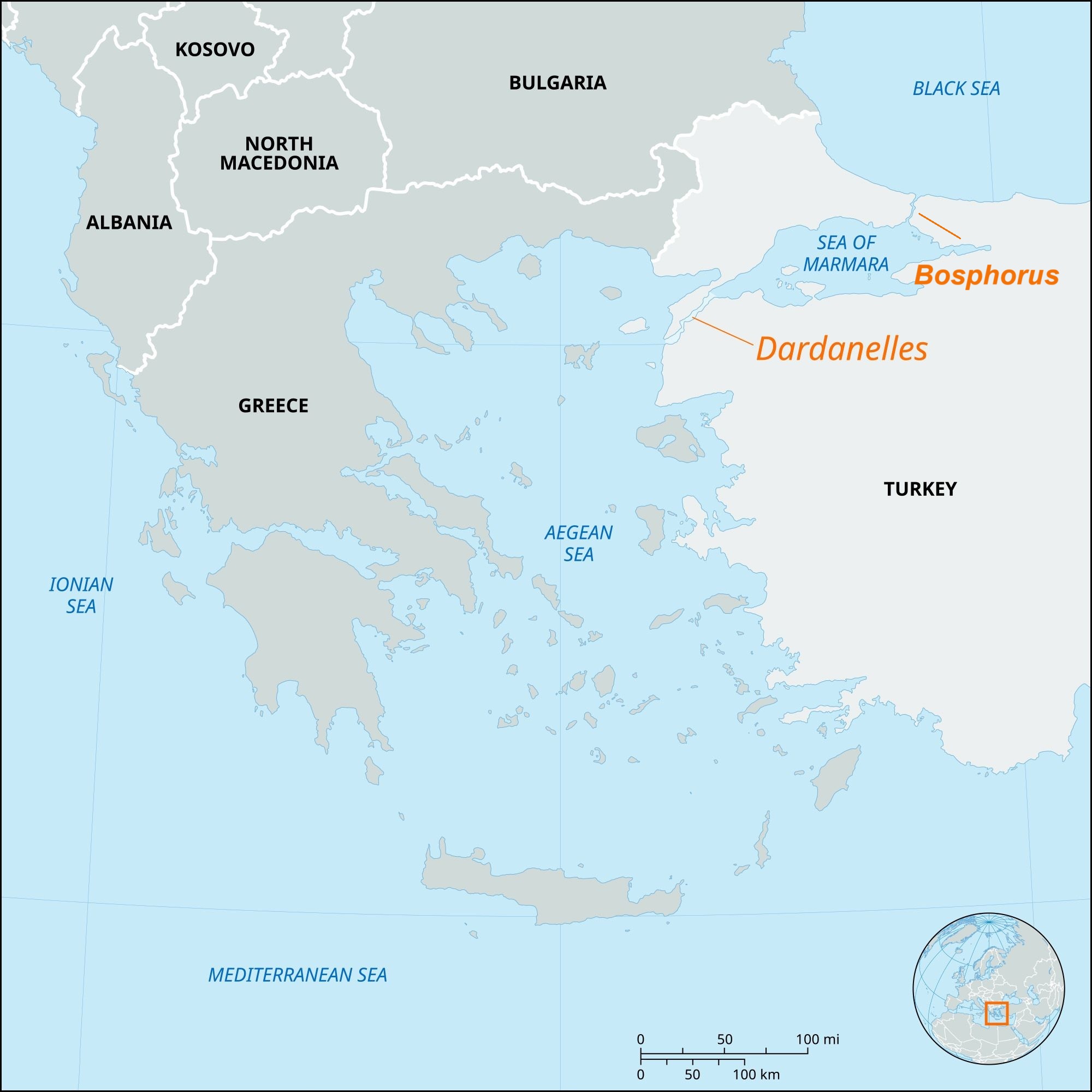
    About Dardanelles Strait:

    • Location: Northwestern Turkey; separates Gallipoli Peninsula (Europe) from Troad/Biga Peninsula (Asia).
    • Connection: Links Aegean Sea → Sea of Marmara → Bosporus → Black Sea.
    • Dimensions: Length 61 km, width 1.2–6.5 km, average depth 55 m, max depth 103 m.
    • Historical Name: Hellespont, named after mythical princess Helle; current name from ancient city of Dardanus.
    • Currents: Surface current flows from Sea of Marmara to Aegean; saline undercurrent in reverse.
    • Ports: Gallipoli, Eceabat, Çanakkale.

    Strategic & Economic Importance:

    • Part of Turkish Straits system with Bosporus; only maritime link between Black Sea and Mediterranean.
    • Critical for Black Sea nations’ trade (Russia, Ukraine, Bulgaria, etc.).
    • Major route for grain, oil, energy shipments from Black Sea region to global markets.
    • Governed by Montreux Convention (1936) for warship passage.
    • Vital for NATO naval strategy and maritime security.
    [UPSC 2008] Through which one of the following Straits does a tunnel connect the United Kingdom and France?

    Options: (a) Davis Strait (b) Denmark Strait (c) Strait of Dover* (d) Strait of Gibraltar


  • The Crisis In The Middle East

    Gaza War Impact on IMEC

    Why in the News?

    India’s National Security Council Secretariat recently hosted envoys from the US, UAE, Saudi Arabia, France, Italy, Germany, Israel, Jordan, and the EU to review progress on the India–Middle East–Europe Economic Corridor (IMEC).

    Gaza War Impact on IMEC

    About IMEC Project:

    • Part of the Partnership for Global Infrastructure and Investment (PGII) for developing connectivity in emerging regions.
    • MoU signed on 10 September 2023 at the G20 New Delhi Summit.
    • Members: India, US, UAE, Saudi Arabia, France, Germany, Italy, European Union.
    • Aim: Integrate Asia, Middle East, and Europe to boost transport efficiency, reduce costs, create jobs, cut greenhouse gas emissions, and strengthen economic unity.
    • Structure:
      • East Corridor: India to Arabian Gulf.
      • Northern Corridor: Gulf region to Europe.
    • Key Ports:
      • India – Mundra, Kandla, Jawaharlal Nehru Port (Mumbai).
      • Middle East – Fujairah, Jebel Ali, Abu Dhabi, Dammam, Ras Al Khair.
      • Israel – Haifa.
      • Europe – Piraeus, Messina, Marseille.
    • Infrastructure includes: Railway links, ship-to-rail hubs, roads, electricity cables, hydrogen pipelines, and high-speed data cables.

    Impact of Gaza War:

    • Derailed work: Conflict from late 2023 halted stakeholder meetings and derailed western leg (Middle East–Europe) progress.
    • Jordan–Israel relations at historic low; Saudi–Israel normalisation stalled.
    • Regional rivalries (e.g., Saudi–UAE trade competition) hinder unified operational planning.

    Significance:

    • Economic: EU is India’s largest trading partner; corridor promises faster, cheaper trade with reduced emissions.
    • Strategic: Strengthens India’s role in West Asia and positions it as a connector between Europe and the Middle East.
    • Energy & Technology: Potential for clean hydrogen pipelines, electricity and data cable links.
    • Resilience: Provides alternative to Red Sea shipping routes vulnerable to disruptions.
    [UPSC 2025] India is one of the founding members of the International North-South Transport Corridor (INSTC), a multimodal transportation corridor, which will connect:

    Options: (a) India to Central Asia to Europe via Iran* (b) India to Central Asia via China (c) India to South-East Asia through Bangladesh and Myanmar (d) India to Europe through Azerbaijan


  • Climate Change Impact on India and World – International Reports, Key Observations, etc.

    In News: Great Barrier Reef

    Why in the News?

    The Great Barrier Reef is facing its sharpest coral decline in 40 years, with the 2024 mass bleaching—driven by climate change, cyclones, and coral predators—severely damaging large reef areas.

    In News: Great Barrier Reef

    About Great Barrier Reef:

    • Location: Coral Sea, off the northeast coast of Queensland, Australia.
    • Length & Area: Extends ~2,300 km; comprises ~3,000 reefs and 900 islands, covering ~350,000 square kilometers (about 10% of global coral reef ecosystems).
    • Biodiversity:
      • Hosts 400 coral species, 1,500 fish species, and 4,000 mollusk species.
      • Habitat for endangered species like the dugong and green turtle.
    • Reef Types: Includes platform reefs, wall reefs, and fringing reefs.
    • Protection Status:
      • Managed by the Great Barrier Reef Marine Park Authority.
      • Declared a United Nations Educational, Scientific and Cultural Organization (UNESCO) World Heritage Site in 1981.
    • Mass Bleaching Years: Notable events occurred in 1998, 2002, 2016, 2017, 2020, 2022, 2024, and 2025.

    Coral Decline and Bleaching Events:

    • Main Cause: Heat stress due to climate change, particularly during marine heatwaves.
    • 2024 Event: Fifth major bleaching since 2016; had the widest spatial impact recorded in the Australian Institute of Marine Science’s 39-year monitoring program.
    • Additional Damage: Cyclones (e.g., Cyclone Jasper) and flood plumes caused physical damage and freshwater stress.
    • Biological Threats: Crown-of-thorns starfish (COTS) outbreaks intensified coral predation, especially in the Swains sector.
    • 2025 Survey Findings:
      • 48% of 124 surveyed reefs showed coral decline.
      • Only 10% recorded an increase in coral cover.
    • Regional Impact: Southern Great Barrier Reef saw a 30.6% drop in hard coral cover—the sharpest annual decline ever recorded in that zone.
    [UPSC 2014] The scientific view is that the increase in global temperature should not exceed 2 0 C above pre-industrial level. If the global temperature increases beyond 30 C above the pre-industrial level, what can be its possible impact/impacts on the world?

    1. Terrestrial biosphere tends toward a net carbon source. 2. Widespread coral mortality will occur. 3. All the global wetlands will permanently disappear.  4. Cultivation of cereals will not be possible anywhere in the world. Select the correct answer using the code given below:

    Options: (a) 1 only (b) 1 and 2 only* (c) 2, 3 and 4 only (d) 1, 2, 3 and 4 only


  • Global Geological And Climatic Events

    Tsunami Waves triggered by quakes in Kamchatka Peninsula

    Why in the News?

    An 8.8 magnitude earthquake hit off Russia’s Kamchatka Peninsula, triggering 16-foot tsunamis that reached Hawaii and northern California in the US.

    About Earthquakes:

    • Overview: Sudden ground shaking caused by release of stored energy in Earth’s crust due to tectonic stress.
    • Cause: Occurs when tectonic plates slip at fault lines where stress had built up due to friction.
    • Seismic Waves: Energy travels as:
      • Primary Waves (P-waves): Fastest, compressional.
      • Secondary Waves (S-waves): Slower, shear motion.
    • Key Terms:
      • Focus (Hypocenter): Underground origin point.
      • Epicenter: Surface point directly above the focus.
    • Measurement:
      • Magnitude: Energy released (Richter Scale, logarithmic).
      • Intensity: Observed ground shaking (varies by location).
      • Seismograph: Records seismic wave activity.

    How Earthquakes Trigger Tsunamis?

    • Underwater Epicenter: Must occur beneath oceans to displace water.
    • Shallow Depth: Quakes at <70 km transfer energy more efficiently to water surface.
    • Reverse Faulting: One tectonic plate pushes over another, vertically shifting the seafloor.
    • Rapid Displacement: Sudden seafloor uplift/downthrust generates massive water waves.
    • High Magnitude: Quakes >7.0 (especially >8.0) likely to trigger tsunamis.

    About the Kamchatka Region:

    • Overview: Russian Far East; borders the North Pacific Ocean.
    • Tectonic Zone: Sits on the Kuril-Kamchatka Trench—Pacific Plate subducting under Okhotsk Plate at ~86 mm/year.
    • Seismic Hotspot: Historical major quakes in 1841, 1923, 1952, 2006, and 2020.
    • Ring of Fire: Part of the 40,000 km Pacific Ring of Fire , known for quakes and volcanoes.
    • 2025 Earthquake:
      • Depth:3 km (shallow)
      • Impact: Triggered tsunami waves up to 16 ft—one of the strongest earthquakes since 1900.
    [UPSC 2004] Consider the following geological phenomena:

    1. Development of a fault 2. Movement along a fault 3. Impact produced by a volcanic eruption 4. Folding of rocks

    Which of the above cause earthquakes?

    Options: (a) 1, 2 and 3 (b) 2 and 4 (c) 1, 3 and 4 (d) 1, 2, 3 and 4*


  • Cuvette Centrale: World’s Largest Tropical Peatland Complex

    Why in the News?

    The Democratic Republic of the Congo (DRC) has launched oil exploration over 124 million hectares of the Cuvette Centrale peatlands raising global ecological risk.

    About the Cuvette Centrale Peatland Complex:

    • Location: Central Congo Basin, spanning the Democratic Republic of the Congo and the Republic of Congo.
    • Size: Covers approximately 145,000–167,600 sq. km—larger than England and about 10% of the Congo Basin.
    • Peat Coverage: Around 40% of the region is underlain by peat—formed over 10,000 years due to flat terrain, rainforest climate, and slow-moving water.
    • Landscape: Features a mosaic of seasonal lakes, floating prairies, swamp forests, rivers, and grasslands.
    • Global Status: The world’s largest near-contiguous tropical peatland complex.

    Ecological Significance:

    • Carbon Storage: Holds about 30–30.6 gigatonnes of carbon—
      • Equal to 3 years of global fossil fuel emissions.
      • Nearly 15 years of U.S. emissions.
      • About 28% of global tropical peat carbon stock.
    • Climate Impact: Acts as a major carbon sink, critical for regulating global temperatures and mitigating climate change.
    • Biodiversity: Habitat for forest elephants, lowland gorillas, and rare plant species.
    • Local Importance: Sustains indigenous livelihoods and maintains regional water cycles.
    • Conservation Status: Recognized as a transnational Ramsar wetland site, highlighting its international ecological value.
    [UPSC 2024] One of the following regions has the world’s largest tropical peatland, which holds about three years’ worth of global carbon emissions from fossil fuels, and the possible destruction of which can exert a detrimental effect on the global climate. Which one of the following denotes that region?

    Options: (a) Amazon Basin (b) Congo Basin* (c) Kikori basin (d) Rio De La Plata Basin


  • Global Geological And Climatic Events

    In news: Kamchatka Peninsula

    Why in the News?

    Five strong offshore earthquakes hit Russia’s Kamchatka Peninsula, the strongest measuring 7.4 in magnitude.

    Kamchatka Peninsula

    About Kamchatka Peninsula:

    • Location: Situated in Far Eastern Russia, bordered by the Sea of Okhotsk (west) and the Pacific Ocean and Bering Sea (east).
    • Size and Shape: Stretches about 1,200 km north to south and 480 km at its widest point.
    • Area: Covers approximately 370,000 square kilometers—comparable in size to New Zealand.
    • Ethnic Composition: Majority are ethnic Russians; around 13,000 belong to the indigenous Koryak community.
    • Climate: Harsh with long, snowy winters and wet, cool summers.
    • Topography: Highest peak is Klyuchevskaya Sopka, an active volcano in the Eastern Mountain Range.
    • Global Recognition: Hosts the “Volcanoes of Kamchatka,” a UNESCO World Heritage Site.

    Tectonic Significance:

    • Geological Setting: Lies on the Pacific Ring of Fire, making it a global hotspot for seismic and volcanic activity.
    • Volcanic Density: Contains over 150 volcanoes, 29 of which are currently active.
    • Kuril–Kamchatka Trench: Located just offshore, reaches depths of about 10,500 meters and drives regional seismicity.
    • Tectonic Cause: Caused by subduction of the Pacific Plate beneath the Eurasian Plate.
    [UPSC 2004] Consider the following geological phenomena:

    1. Development of a fault 2. Movement along a fault

    3. Impact produced by a volcanic eruption 4. Folding of rocks

    Which of the above cause earthquakes?

    Options: (a) 1, 2 and 3 (b) 2 and 4 (c) 1, 3 and 4 (d) 1, 2, 3 and 4*


  • Disputes over Grand Ethiopian Renaissance Dam (GERD)

    Why in the News?

    The completion of Ethiopia’s Grand Ethiopian Renaissance Dam (GERD) has reignited tensions over Nile water rights, with Egypt and Sudan fearing reduced water flows.

    Disputes over Grand Ethiopian Renaissance Dam (GERD)

    About Grand Ethiopian Renaissance Dam (GERD):

    • Overview: Gravity dam on the Blue Nile near Ethiopia–Sudan border.
    • Construction Timeline: Under construction since 2011, led by Ethiopian Electric Power Corporation.
    • Capacity: Set to become Africa’s largest hydropower plant with 6.45 GW output.
    • Reservoir Size: Holds 74 billion cubic metres; filling may take 5–15 years.
    • Key Features: 145 m tall dam, 16 turbines, and a supporting saddle dam.
    • Purpose: Aims to power Ethiopia (65% population lacks electricity) and export surplus to neighbouring countries.
    • Disputes Around GERD:
      • Egypt’s Concern: Fears reduced water flow; Relies 90% on Nile; demands a binding filling agreement.
      • Sudan’s Worry: Concerns over flood risks and water regulation.
      • Ethiopia’s Stand: Asserts sovereign rights; began filling without consensus.
      • Stalled Talks: Tripartite negotiations have failed; Egypt warns of possible conflict.

    Back2Basics: Nile River

    • Overview: North-flowing, longest river in Africa at ~6,650 km.
    • Drainage Basin: Covers 11 countries—Tanzania, Uganda, Rwanda, Burundi, DRC, Kenya, Ethiopia, Eritrea, South Sudan, Sudan, and Egypt.
    • Main Tributaries:
      • White Nile: Recognized as the headstream, its most remote source is the Kagera River in Burundi, flowing through Rwanda into Lake Victoria. It officially begins at Jinja, Uganda, where it exits Lake Victoria.
      • Blue Nile: Originates from Lake Tana in Ethiopia and merges with the White Nile at Khartoum, Sudan.  Supplies over 80% of total Nile flow by the time it reaches Egypt.
    • Lifeline Status: Vital for Egypt and Sudan’s drinking water, irrigation, and energy needs.


    [UPSC 2008] Ogaden region has been a source of conflict between which countries?

    Options: (a) Morocco and Algeria (b) Nigeria and Cameroon (c) Angola and Zambia (d) Ethiopia and Somalia*


  • Global Geological And Climatic Events

    Indonesia’s Mount Lewotobi erupts

    Why in the News?

    Mount Lewotobi Laki Laki in eastern Indonesia has erupted violently, spreading ash up to 18 kilometers into the sky.

    About Mount Lewotobi: Key Features

    • Overview: Mount Lewotobi is a twin volcano located in East Nusa Tenggara province, consisting of Lewotobi Laki Laki (“Male”) and Lewotobi Perempuan (“Female”).
    • Elevation and Activity: Lewotobi Laki Laki stands at 1,584 meters and is more frequently active. Lewotobi Perempuan is taller at 1,703 meters but less active historically.
    • Volcanic Type: Both mountains are stratovolcanoes, formed by successive layers of lava, ash, and volcanic debris.
    • Lava Domes: During the 20th century, both volcanoes developed small lava domes within their summit craters.
    • Magma Composition: The primary eruptive material from both volcanoes is andesite, a type of intermediate volcanic rock.
    • Tectonic Location: The volcanoes lie on the Pacific Ring of Fire, a seismically active belt known for frequent earthquakes and volcanic eruptions.

    Back2Basics: The Pacific Ring of Fire

    • Overview: The Pacific Ring of Fire is a 40,000-km-long horseshoe-shaped zone encircling much of the Pacific Ocean, known for intense geological activity.
    • Volcanic Density: This region contains around 75 percent of the world’s volcanoes—more than 450 in total.
    • Seismic Activity: Approximately 90 percent of the world’s earthquakes occur within this zone.
    • Geographic Spread: It extends from New Zealand through Indonesia, the Philippines, and Japan, across to the Aleutian Islands, and then down the western coasts of North and South America.
    • Tectonic Plates Involved: Several major tectonic plates intersect here, including the Pacific, Philippine, Juan de Fuca, Cocos, Nazca, and North American plates.
    • Subduction Zones: Much of the Ring features subduction zones, where one tectonic plate slides beneath another, generating magma and leading to volcanic eruptions.
    • Plate Movement: The movement of these plates is slow—typically just one to two inches per year—but it results in significant geological events over time.


    [UPSC 2018] Consider the following statements:

    1. The Barren Island volcano is an active volcano located in the Indian territory.

    2. Barren Island lies about 140 km east of Great Nicobar.

    3. The last time the Barren Island volcano erupted was in 1991 and it has remained inactive since then. Which of the statements given above is/are correct?

    Options: (a) 1 only (b) 2 and 3 (c) 3 only (d) 1 and 3


  • Global Geological And Climatic Events

    1000 quakes rattle Japan’s Tokara Islands

    Why in the News?

    Japan has recorded over 1,000 tremors in two weeks near the Tokara Islands, signalling a surge in seismic activity.

    Why is Japan so prone to earthquakes?

    • Tectonic Plate Convergence: Japan lies at the junction of four major tectonic plates—the Pacific, Philippine Sea, Eurasian, and North American—which constantly collide and shift.
    • Subduction Zones: Oceanic plates (Pacific and Philippine Sea) are being pushed under continental plates, creating intense geological stress that is released as earthquakes.
    • Pacific Ring of Fire: Japan is part of this highly active seismic zone that surrounds the Pacific Ocean and accounts for about 90% of the world’s earthquakes.
    • Volcanic and Fault Line Density: The country has about 10% of the world’s active volcanoes and numerous fault lines, increasing its seismic vulnerability.

    About Tokara Islands:

    • Overview: They are a small volcanic island chain in the Ryukyu archipelago, forming part of Kagoshima Prefecture in southern Japan:
    • Geographical Location: Between Kyushu and the Amami Islands, in the East China Sea.
    • Composition: Includes 12 islands, of which 7 are inhabited, such as Nakanoshima, Takarajima, and Kodakarajima.
    • Volcanic Origin: Part of the Ryukyu Arc, a highly seismically active zone. Mount Otake, an active volcano, is located on Nakanoshima.
    • Geopolitical Relevance: The islands are gaining strategic significance due to rising tensions in the East China Sea, particularly involving China and Taiwan. Recent defense policies have called for fortification of the Tokara and Nansei Islands to enhance surveillance.
    [UPSC 2008] In the year 2007, an earthquake led to massive radioactive water leakage in the largest nuclear plant in the world. In which country did it occur?

    Options: (a) Germany (b) Canada (c) Japan* (d) USA


  • Iran’s Nuclear Program & Western Sanctions

    Places in news: Strait of Hormuz

    Why in the News?

    Iran’s Parliament has approved a motion to block the Strait of Hormuz, raising concerns worldwide.

    Strait of Hormuz

    About the Strait of Hormuz:

    • Geographic Location: The Strait of Hormuz is a narrow waterway that connects the Persian Gulf to the Gulf of Oman and eventually to the Arabian Sea.
    • Dimensions: It is about 167 km long and 33 km wide at its narrowest, making it one of the world’s most strategic maritime chokepoints.
    • Bordering Countries: The strait lies between Iran (north) and Oman (south), with nearby cities such as Bandar Abbas, Khasab, and Dubai.
    • Shipping Lanes: It contains designated lanes just 3 km wide in each direction to manage heavy oil tanker traffic.
    • Key Islands: Important islands include Qeshm, Hormuz, and Hengam (controlled by Iran) and disputed ones like Abu Musa and the Tunbs, claimed by both Iran and the UAE.
    • Naval Depth Advantage: Waters near the Musandam Peninsula reach depths over 650 feet, ideal for deep-draft oil tankers.
    • Security Risks: Due to its narrowness, the strait is vulnerable to disruption from mining, military action, or cyber interference.
    • Historical Tensions: It has witnessed frequent maritime tensions, especially during Iran–West conflicts but has never been fully blocked.

    Its significance:

    • Global Oil Flow: Over 20 million barrels of crude oil per day pass through the strait, accounting for 25% of seaborne oil trade and 20% of global consumption.
    • Gas Exports: It is vital for LNG exports, especially from Qatar, reaching markets across the globe.
    • Asian Dependence: Countries like India, China, Japan, and South Korea import 69% of the oil that flows through the strait.
    • Market Sensitivity: Any disruption can spike global oil prices, increasing fuel and commodity costs worldwide.
    • Limited Alternatives: Overland pipelines like Saudi Arabia’s East-West (5 million bpd) and UAE’s Habshan-Fujairah (1.8 million bpd) offer only partial alternatives.

    Implications of Blockade:

    • Shipping Costs: During geopolitical tensions, insurance and freight charges for using the strait surge significantly.
    • India’s Vulnerability: India relies heavily on the region for oil imports, so instability could raise inflation, disrupt energy supplies, and impact the trade balance.
    • Strategic Response: A full blockade could trigger direct military action, particularly from the US 5th Fleet based in Bahrain.
    • Mutual Economic Impact: Disruption would affect both exporters and importers, including Iran and its major customer, China.
    [UPSC 2010] Which one of the following can one come across if one travels through the Strait of Malacca?

    Options: (a) Bali (b) Brunei (c) Java (d) Singapore*