Why in the News?
The Democratic Republic of the Congo (DRC) has launched oil exploration over 124 million hectares of the Cuvette Centrale peatlands raising global ecological risk.
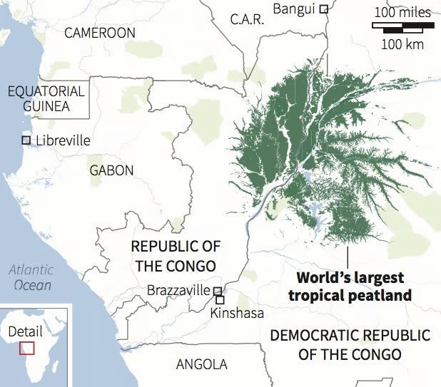
About the Cuvette Centrale Peatland Complex:
- Location: Central Congo Basin, spanning the Democratic Republic of the Congo and the Republic of Congo.
- Size: Covers approximately 145,000–167,600 sq. km—larger than England and about 10% of the Congo Basin.
- Peat Coverage: Around 40% of the region is underlain by peat—formed over 10,000 years due to flat terrain, rainforest climate, and slow-moving water.
- Landscape: Features a mosaic of seasonal lakes, floating prairies, swamp forests, rivers, and grasslands.
- Global Status: The world’s largest near-contiguous tropical peatland complex.
Ecological Significance:
- Carbon Storage: Holds about 30–30.6 gigatonnes of carbon—
- Equal to 3 years of global fossil fuel emissions.
- Nearly 15 years of U.S. emissions.
- About 28% of global tropical peat carbon stock.
- Climate Impact: Acts as a major carbon sink, critical for regulating global temperatures and mitigating climate change.
- Biodiversity: Habitat for forest elephants, lowland gorillas, and rare plant species.
- Local Importance: Sustains indigenous livelihoods and maintains regional water cycles.
- Conservation Status: Recognized as a transnational Ramsar wetland site, highlighting its international ecological value.
| [UPSC 2024] One of the following regions has the world’s largest tropical peatland, which holds about three years’ worth of global carbon emissions from fossil fuels, and the possible destruction of which can exert a detrimental effect on the global climate. Which one of the following denotes that region?
Options: (a) Amazon Basin (b) Congo Basin* (c) Kikori basin (d) Rio De La Plata Basin |