Why in the News?
A landslide in Sudan’s western Darfur region reportedly wiped out a village, killing an estimated 1,000 people.
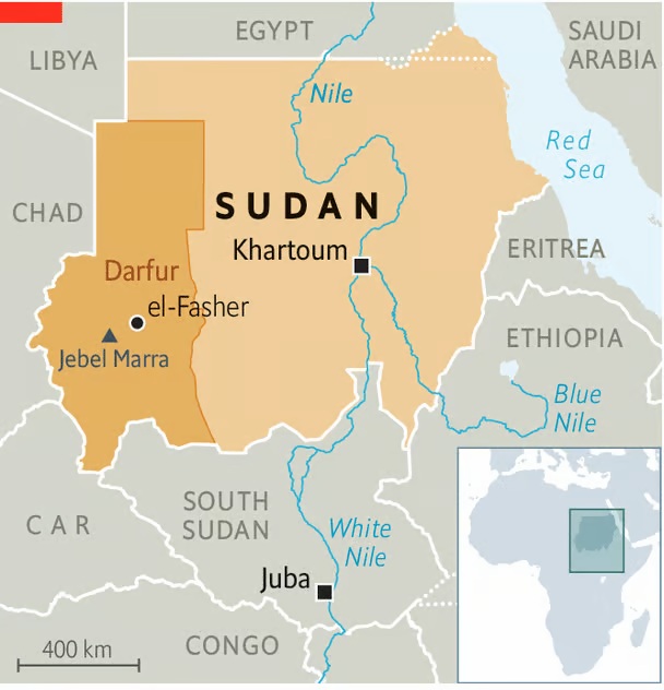
About Darfur Region:
- Location & Size: Western Sudan; borders Chad, Libya, CAR; spans about 493,000 sq. km (nearly France-sized).
- Geography: Predominantly arid/semi-arid; desert north, fertile south. Highly vulnerable to drought, desertification, and climate change.
- Administrative Units: Divided into five states — North, South, West, Central, East Darfur.
- Demographics: Mixed ethnic groups — Arab pastoralists and non-Arab farming communities.
- Capital: El Fasher, main hub for administration, economy, and humanitarian operations.
Ongoing Conflict & Crisis:
- Origins of Uprising: Armed rebellion began in 2003 (SLM, JEM) against political and economic marginalization.
- Janjaweed & RSF: Janjaweed militias, accused of genocide and ethnic cleansing, later evolved into Rapid Support Forces (RSF), now central to instability.
- Humanitarian Crisis: Since 2003, region has seen mass killings, displacement, refugee flows, ranked among the worst global humanitarian crises.
- Current Instability: Renewed 2023 violence between RSF and rival groups worsened agriculture, aid, and governance.
- Regional Impact: Conflict spills into Chad and CAR, destabilizing the Sahel region.
- Natural Disasters: Alongside conflict, disasters like the 2025 Darfur landslide (~1,000 deaths) add to human suffering.
| [UPSC 2024] Consider the following statements:
Statement-I: There is instability and worsening security situation in the Sahel region. Statement-II: There have been military takeovers/coups d’état in several countries of the Sahel region in the recent past. Which one of the following is correct in respect of the above statement? a) Both Statement-I and Statement-II are correct and Statement-II explains Statement-I b) Bothe Statement-I and Statement-II are correct, but Statement-II does not explain Statement-I c) Statement-I is correct, but Statement-II is incorrect d) Statement-I is incorrect, but Statement-II is correct |