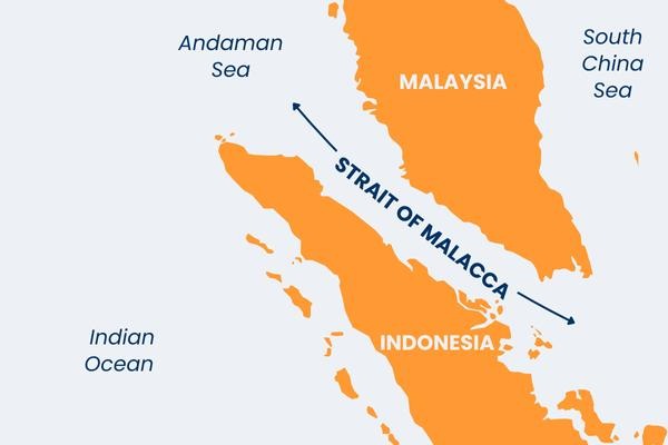
A boat carrying Rohingya refugees capsized in the Andaman Sea, highlighting its strategic and humanitarian importance.
About the Andaman Sea
What it is
A marginal sea of the northeastern Indian Ocean
Acts as a maritime link between:
South Asia
Southeast Asia
Location
Lies between:
4°N to 20°N latitude
92°E to 100°E longitude
Connected Water Bodies
West: Bay of Bengal
East: South China Sea (via Strait of Malacca)
Boundaries
North: Irrawaddy delta (Myanmar)
East: Myanmar, Thailand, Malaysia
South: Indonesia (Sumatra)
West: Andaman & Nicobar Islands (India)
Origin of Name
Derived from “Handuman” (Malay form of Hanuman)
Linked to ancient maritime trade and cultural exchanges
[2020] Consider the following pairs: River – Flows into 1. Mekong — Andaman Sea 2. Thames — Irish Sea 3. Volga — Caspian Sea 4. Zambezi — Indian Ocean Which of the pairs given above is/are correctly matched? a) 1 and 2 only b) 3 only c) 3 and 4 only d) 1, 2 and 4 only
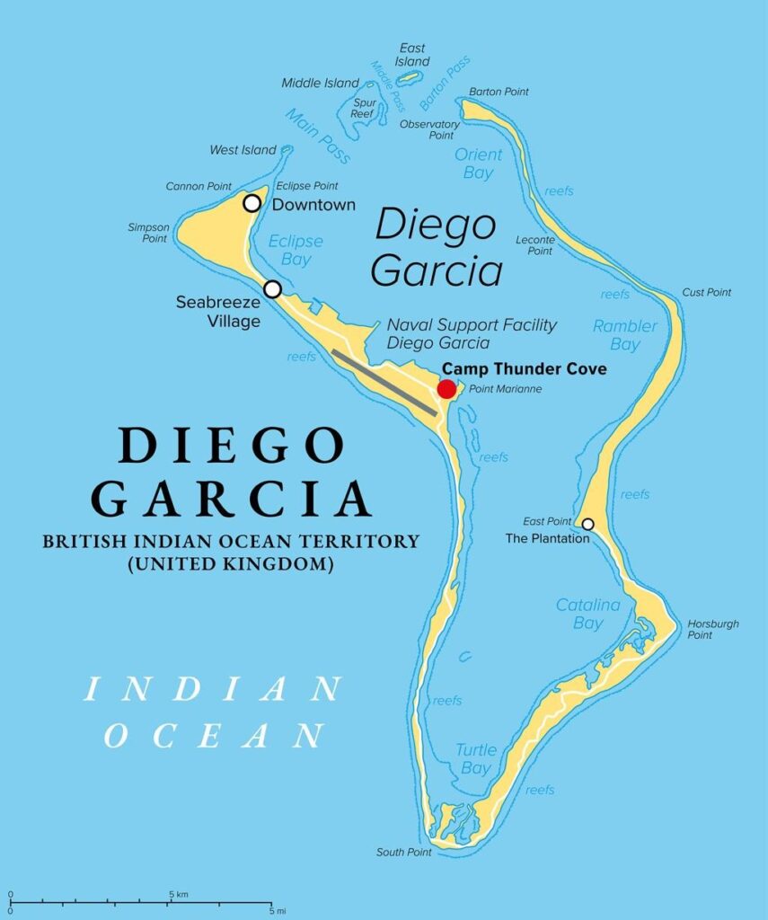
The United Kingdom has put on hold the deal to cede sovereignty of the Chagos Islands, keeping the long-running UK–Mauritius sovereignty dispute unresolved.
About the Chagos Islands
Location: Central Indian Ocean
Distance: About 1,600 km south of India
Type: Archipelago (group of islands)
Status:British Overseas Territory
Established:1965 (British Indian Ocean Territory)
Major Islands in Chagos Archipelago
Diego Garcia (Largest island)
Peros Banhos Atoll
Solomon Islands
Egmont Islands
Eagle Islands
Nelsons Island
Three Brothers Islands
Danger Island
[2022] Which one of the following statements best reflects the issue with Senkaku Islands, sometimes mentioned in the news? a) It is generally believed that they are artificial islands made by a country around South China Sea. b) China and Japan engage in maritime disputes over these islands in East China Sea. c) A permanent American military base has been set up there to help Taiwan to increase its defence capabilities. d) Though International Court, of Justice declared them as no man’s land, some South-East Asian countries claim them.
The Philippines opened a new Coast Guard base on Thitu Island (Pag-asa Island) in the South China Sea, strengthening its presence in a disputed maritime region claimed by China.
Key Highlights
Location: Thitu Island (Pag-asa Island)
Region: South China Sea
Purpose: Strengthen sovereignty and maritime security
The base will include:
Patrol ships
Aircraft
Surveillance systems
Search and rescue operations
The base will also support:
Fishermen protection
Environmental monitoring
Law enforcement
Why the South China Sea is Important
Major global trade route
Rich in:
Fisheries
Oil and gas reserves
Strategic military importance
Dispute in the South China Sea
China claims almost the entire South China Sea, including areas claimed by:
Philippines
Vietnam
Malaysia
Brunei
Taiwan
China’s claim is based on the Nine-Dash Line, which was:
Rejected by 2016 International Arbitration Tribunal
Based on UNCLOS (1982)
China rejected the ruling and continues to assert control.
About Thitu Island (Pag-asa Island)
Located in Spratly Islands
Controlled by Philippines since 1970s
About 400 residents
Strategic location near Chinese military bases
China has built artificial islands and military infrastructure nearby, including Subi Reef.
[2022] With reference to the United Nations Convention on the Law of Sea, consider the following statements: 1 A coastal state has the right to establish the breadth of its territorial sea up to a limit not exceeding 12 nautical miles, measured from baseline determined in accordance with the convention. 2 Ships of all states, whether coastal or land-locked, enjoy the right of innocent passage through the territorial sea. 3 The Exclusive Economic Zone shall not extend beyond 200 nautical miles from the baseline from which the breadth of the territorial sea is measured. Which of the statements given above are correct? (a) 1 and 2 only (b) 2 and 3 only (c) 1 and 3 only (d) 1, 2 and 3
The Supreme Court refused to interfere with environmental clearance granted to the Kozhikode Wayanad twin tube tunnel project in Kerala’s Western Ghats.
Supreme Court Observation
Project appears of national importance
Kerala faces:
Land scarcity
Road congestion
Transport bottlenecks
Court noted:
Tunnels common worldwide
Experts will handle safety concerns
About Kozhikode Wayanad Tunnel Project
Twin tube tunnel corridor
Connects:
Kozhikode district
Wayanad district
Located in Western Ghats
Landslide prone region
Concerns Raised
Petitioner NGO argued:
Near Nilgiri Biosphere Reserve
Ecologically fragile Western Ghats
Landslide prone area
Risk from blasting and vibrations
Should receive Category A environmental clearance
[2016] ‘Gadgil Committee Report’ and ‘Kasturirangan Committee Report’, sometimes seen in the news, are related to (a) constitutional reforms (b) Ganga Action Plan (c) linking of rivers (d) protection of Western Ghats
Gabon is negotiating with the International Monetary Fund for a new loan programme to stabilise its finances after political instability and economic challenges.
Background of the Crisis
Gabon has faced political instability including: A military coup, A contentious election and Four Finance Ministers in three years
This instability has weakened fiscal management and reduced investor confidence.
Purpose of IMF Assistance
Gabon wants an IMF programme to:
Stabilise public finances
Improve transparency and fiscal discipline
Unlock international funding and investor capital
An IMF programme often acts as a signal of credibility for global investors.
Regional Impact
Gabon is part of the Central African Economic and Monetary Community.
Several CEMAC countries are also considering IMF assistance due to a regional funding crunch.
Therefore, Gabon’s IMF programme could influence financial stability across the region.
Challenges to Securing the Loan
Experts highlight several concerns:
Debt transparency issues
Weak availability of economic data
Need for difficult fiscal reforms
Government’s expansionary fiscal policies
Gabon’s previous IMF programme (approved in 2021) went off-track after one year, increasing scepticism.
[2022] “Rapid Financing Instrument” and “Rapid Credit Facility” are related to the provisions of lending by which one of the following? (a) Asian Development Bank (b) International Monetary Fund (c) United Nations Environment Programme Finance Initiative (d) World Bank
India and Finland have elevated their bilateral relations to a “Strategic Partnership in Digitalization and Sustainability” after talks between Narendra Modi and Finnish President Alexander Stubb in New Delhi.
Key Outcomes of the Visit
Strategic Partnership Focus
Cooperation will expand in high-technology sectors such as:
Artificial Intelligence
6G telecommunications
Clean energy
Quantum computing
Digital infrastructure
Agreements Signed
Three agreements were signed in the fields of:
Mobility cooperation
Environment and sustainability
Statistics and data sharing
New Institutional Mechanisms
The two countries will establish:
Joint Working Group on Digitalization
Joint Task Force on 6G technology
Consular Dialogue mechanism
Greater connectivity between startup ecosystems
Economic Cooperation
India and Finland aim to double bilateral trade by 2030.
The countries will co-host the World Circular Economy Forum in India.
Cooperation expected in sectors such as: Defence, Space, Semiconductors and Critical minerals
Existing India–Finland Cooperation
Examples highlighted during the meeting include:
Finnish company Nokia helping build telecom networks in India.
Finnish architectural collaboration in constructing the Chenab Railway Bridge.
Finland’s partnership in establishing the world’s largest bamboo-to-bioethanol refinery at Numaligarh in Assam.
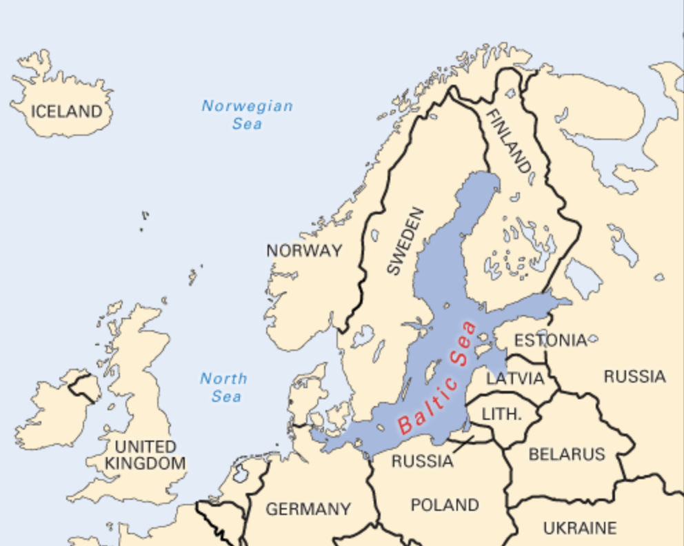
Consider the following countries: 1. Finland 2. Germany 3. Norway 4. Russia How many of the above countries have a border with the North Sea? (a) Only one (b) Only two (c) Only three (d) All four
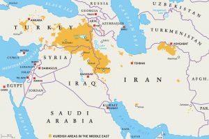
Renewed fighting has erupted in Syria between government forces led by interim leader Ahmed al-Sharaa and the Kurdish-led Syrian Democratic Forces (SDF), threatening to roll back Kurdish autonomy that has existed since the 2011 civil war.
Background Context
The regime of Bashar al-Assad collapsed in December 2024
Ahmed al-Sharaa promised an inclusive administration but pushed for a centralised Syrian state
Ethnic and religious minorities, including Kurds, resisted centralisation
Sectarian violence resurfaced against Alawites and Druze, followed by clashes with Kurds
Who Are the Syrian Kurds?
Kurds form about 10 percent of Syria’s population
Concentrated in north and northeast Syria
Long standing demand for autonomy, not secession
In 2012, Assad withdrew troops from the northeast
Kurds filled the vacuum and declared autonomous regions called cantons
These areas together formed the Democratic Autonomous Administration of North and East Syria (DAANES), also called Rojava
[2016] Consider the following pairs: Community sometimes mentioned in the news : In the affairs of
1. Kurd : Bangladesh
2. Madhesi : Nepal
3. Rohingya : Myanmar
Which of the pairs given above is/are correctly matched?
A controlled avalanche was artificially triggered on Mount Elbrus in Russia to safely release accumulated snow following heavy snowfall, reducing the risk of natural avalanches.
About
Highest mountain in Europe
An ancient, extinct volcano with two distinct peaks
Part of the Caucasus mountain system
Major hub for mountaineering and alpine tourism
Location
Situated in southwestern Russia
Lies in the Caucasus Mountains, just north of the Georgia border
Located between the Black Sea and Caspian Sea mountain corridor
Key geological features
Twin coned stratovolcano formed over 2.5 million years ago
Highest peak at 5,642 metres
Second peak at 5,595 metres
Covered by 22 glaciers
Feeds major rivers such as Kuban and Terek
Though dormant for nearly 2,000 years, still shows sulphurous gas emissions and mineral springs
Significance
Officially recognised as Europe’s highest peak
Included among the Seven Summits for global climbers
Important site for glaciological research and climate change studies
Observed by scientific missions including the International Space Station
Economically vital for tourism and adventure sports in the Caucasus region
UPSC Prelims Pointers
Mount Elbrus is higher than Mont Blanc
It is an extinct stratovolcano, not a fold mountain
Located in the Caucasus, between the Black Sea and Caspian Sea
Hosts extensive glaciation despite being dormant
Controlled avalanches are used for disaster risk reduction in high mountain regions
Recently, Israel formally recognised the self declared Republic of Somaliland as an independent and sovereign state.
About Somaliland
Located in the Horn of Africa • Borders Djibouti, Ethiopia, Somalia, and the Puntland region • Has a strategic coastline along the Gulf of Aden • Capital city Hargeisa
Economy and Infrastructure
Economy primarily livestock based • Major exports of livestock to Gulf countries • Berbera Port is being developed as a regional trade and logistics hub • Port plays a key role in providing access to sea trade for landlocked Ethiopia
Prelims Pointers
Somaliland is not a UN recognised state despite functioning independently • Located along a strategic maritime route near the Bab el Mandeb region • Unique political system combining customary institutions and democracy • Berbera Port enhances regional connectivity in the Horn of Africa
Which of the following countries has been suffering from decades of civil strife and food shortages and was in news in the recent past for its very severe famine? [2023]